Publicerad den Lämna en kommentar

Engcon stödjer nu Trimbles nya grävsystem

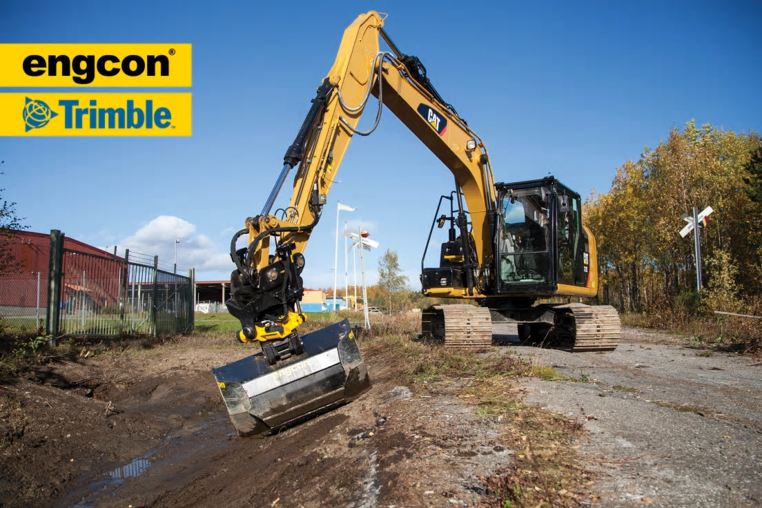
Världsledande tiltrotatortillverkaren Engcon samarbetar med de flesta etablerade tillverkarna av maskinstyrningar och grävsystem, för att ge kunderna största möjliga nytta. Maskin- och grävsystemstillverkaren Trimble uppdaterade nyligen sina system till den nya generationen ”Earthworks”. Engcon kan nu meddela att man redan anpassat sina produkter för nya ”Earthworks”.

Med anledning av att Trimble uppdaterat sitt grävsystem har Engcon anpassat sitt populära ePS (engcon Positioning System), som nu är fullständigt kompatibelt med Trimble Earthworks. Tack vare Engcons snabba anpassning är det fullt möjligt att följa roteringsplanet i Trimbles uppgraderade grävsystem.

– Vi har väldigt bra samarbete med de flesta tillverkarna av grävsystem och tack vare det blir det kortare ledtider på våra anpassningar för att synkronisera våra produkter med tillverkarnas, säger Roberth Jonsson, platschef på Microprop, som bygger Engcons styrsystem och anpassningar för grävsystem.

Engcon hänvisar frågor om Trimble Earthworks till Trimbles återförsäljare. Eventuella frågor om ePS besvaras av Engcon.

engcon är världsledande tillverkare av tiltrotatorer (grävmaskinens handled) och tillhörande redskap som ökar grävmaskiners flexibilitet, precision och säkerhet. Med kunskap, engagemang och hög servicenivå skapar vi framgång för våra kunder.

engcon är en större koncern bestående av moderbolaget engcon Holding AB med säte i Strömsund, Sverige och utöver det ansvarar 8 säljbolag för försäljningen i sina respektive marknader Sverige, Norge, Finland, Danmark, England, Tyskland, Frankrike och Nederländerna och för övriga marknader ansvarar engcon International. engcon-gruppen omsatte 2016 ca 870 Msek med ca: 200 anställda. www.engcon.com

Content retrieved from: http://www.mynewsdesk.com/se/engcon/pressreleases/engcon-stoedjer-nu-trimbles-nya-graevsystem-2321563.

Publicerad den Lämna en kommentar

SBG Geo 2018

splash_prof_2018

Geo 2018

Generellt

Ny årsmodell och några mindre uppdateringar på viktiga funktioner och ett par riktigt efterlängtade nyheter. Först en mindre uppdatering av LandXML-import, från denna version kan man läsa lat/long i form av cgpoints. En väldigt efterlängtad utökning för alla som inte har förmånen att mäta med GeoPad i fält.
Standardintällningen för koordinataxlar i koordinatsystem är nu uppdaterad för att följa standarden i t.ex Sweref, vi byter helt enkelt XYZ mot NEH. Förhoppningsvis blir det mindre förvirring om vad som är norr i fortsättningen. Vi har även uppdaterat volymberäkningen av MBS så att vi kan använda dwg-filer med ytor som terrängmodeller för t.ex jord och berg.
Det kommer som sagt även lite större nyheter som vi går igenom lite mera här nedan.

Omlottmätning

En helt ny och länge saknad funktion i Geo som framför allt hjälper våra järnvägsbyggare en hel del i vardagen. Vi har infört omlottmätning enligt SIS TS med regeltolkning enligt järnväg, vi gjorde dock funktionen lite mera flexibel så att vi kan använda den vid de flesta typer av omlottmätningar för kontroll av noggrannhet. Funktionen hittar vi under menyn ”funktion”, omlottmätning. Kontroll kan ske vinkelrätt mot mätt/skapad linje, vinkelrätt mot en referenslinje (spårlinje eller väglinje) eller radiellt. Vid vinkelrät kontroll av omlottmätning krävs att varje mätning (stationsuppställning) är mätt som polylinje eller att referenslinje används.

Vid beräkning skapas nya medelvärdespunketer baserat på de godkända omlottmätningarna enligt bild nedan:

Nedan kommer ett exempel på rapporter vid olika kontroller på samma data:

Förhandsvisning av tvärsektion från multipla ytor

Vi trm_pre2har infört ett nytt grafiskt verktyg där du kan förhandsvisa ett tvärsnitt genom en eller flera ytor som kan vara terängmodell (*.trm) eller AutoCad fil (*dxf, *dwg). Verktyget kan antingen användas tillsammans med en linjefil (*.l3d, *.lin) eller utan detta. Med aktiv linje kan tvärsektioner vinkelrätt vald linje visas i den nya grafiska panelen, utan linje kan man istället peka ut två punkter som tvärsnittet ska visas mellan. Tvåpunktsmetoden fungerar även när man har en linje aktiv.


Volymberäkning av terrängmodeller

Vid volymberäkning mellan två terrängmodeller kan vi nu skapa skärningen mellan dessa modeller som en höjdsatt polylinje i geo-format. En funktion som vi tror minskar antalet moment i det dagliga arbetet med modeller.

Punktmoln från Leica MS50/60

Vid flera skanningar från samma stationsuppställning med Leicas Multistation-instrument har vi tidigare alltid importerat samtliga skanningar. Nu har vi infört ett val där man kan välja bort felaktiga eller icke önskade skanningar direkt vid import.

Content retrieved from: http://sbg.se/2017/11/geo-2018/.

Publicerad den Lämna en kommentar

2017-2022 Global GPS & GNSS Receivers Market Analysis : Trimble, Topcon, Navipedia, SOKKIA, Geo

Global GPS & GNSS Receivers Market

The GPS & GNSS Receivers Market 2017 Research Report investigates a thorough and complete study on GPS & GNSS Receivers industry volume, market Share, market Trends, GPS & GNSS Receivers Growth aspects, wide range of applications, Utilization ratio, Supply and demand analysis, manufacturing capacity and GPS & GNSS Receivers industry Price during Forecast period from 2017 to 2022

The research report labeled Global GPS & GNSS Receivers Market 2017 presents the penetrating study of GPS & GNSS Receivers market globally, concentrating on complete analysis of the present and past historical details of GPS & GNSS Receivers market. The competitive landscape view of the GPS & GNSS Receivers industry is also covered in this research document.

Request Report Sample Here: bit.ly/2vjWVPd

Competitive Study of Global GPS & GNSS Receivers Market 2017 Based on Key Vendors:

1 Trimble
2 Topcon
3 Navipedia
4 SOKKIA
5 Geo
6 NavtechGPS
7 JAVAD GNSS
8 CHC Navigation
9 SOUTH
10 ComNav Technology
11 Hemisphere GNSS
12 NovAtel
13 NavCom Technology
14 Leica-geosystems
15 Eos Positioning Systems
16 NVS Technologies
17 Suzhou FOIF
18 Pulse Engineering
19 CSR
20 BroadCom
21 Garmin

The report organizes the GPS & GNSS Receivers market across the globe into distinct portion based on industry standards. It also distinguishes the market based on geographical regions. The GPS & GNSS Receivers report mainly throws light on dominant players in the regions of (United States, EU, China, and Japan). Other regions can be added accordingly.

Discrete aspects of the GPS & GNSS Receivers industry like value chain analysis, GPS & GNSS Receivers industry rules and policies, the factors driving the growth of the market and the constraints hampering the growth are explained.

In next section, the GPS & GNSS Receivers report mentions the products that are currently available in the market along with their cost structures, manufacturing volume, requirement and supply analysis, import/export scenario and their overall contribution to the GPS & GNSS Receivers market revenue globally.

Buy Complete Report Here (To Get Instant access): market.biz/report/global-gps-gnss-receivers-market-2017-2…

Further, the report global GPS & GNSS Receivers market 2017 analyzes the feasibility of investment, investment return analysis and shows a complete picture of market development scope and business strategies followed by leading GPS & GNSS Receivers industry players along with their company profile, market share and contact information.

Lastly, the GPS & GNSS Receivers report enlists the vital conclusions that will assist all individuals who have a keen interest in GPS & GNSS Receivers Market.

About Us:

Market.Biz is designed to provide the best and most penetrating research required to all commercial, industrial and profit-making ventures in any sector of online business. We take pride in our ability to satisfy the market research needs of both domestic and international businesses.

Contact Us:

James Johnson
S no. 51/14 First Floor,
Office Number 4, Vishwa Arcade,
Near Navale Lawns, Pune
Maharashtra, India 411041

Tel: +1(857)2390696
Web: market.biz/
Email: inquiry@market.biz

Browse Latest News- firstnewshawk.com/

This release was published on openPR.


Content retrieved from: http://www.openpr.com/news/625341/2017-2022-Global-GPS-GNSS-Receivers-Market-Analysis-Trimble-Topcon-Navipedia-SOKKIA-Geo.html.

Publicerad den Lämna en kommentar

Trimble S5 Ti-M Monitoring Total Station

Trimble S5 Ti-M Monitoring Total Station

Trimble S5 Ti-M
S5
S5

Features

  • The S5 Ti-M Total Station is a scalable and cost effective solution for a variety of monitoring applications.  It’s performance is ideal for construction projects of any size, from short-term jobs to multi-year construction operations that require monitoring for site safety including:

  • Trimble FineLock technology delivers a point precision of less than 1 millimeter at a distance of 300 meters

  • Trimble DR Plus EDM technology ensures accurate data with fewer instruments, a cost saving on large and small project sites

  • The Trimble S5 Ti-M detects targets without interference from surrounding prisms, ensuring target lock over long distances

  • The Trimble 4D control Software makes it easy to set real time notifications when structural or environmental movements occur, resulting in timely safety decisions

Product Resources

  • Datasheet

  • Video

  • Support

  • Overview

  • Software

  • Compatible Products

The Trimble S5 Ti-M Monitoring Total Station will meet the monitoring requirements on any construction job site. This accurate and reliable total station helps you to work more efficiently with less equipment.

Keep the Site Safe

The S5 Ti-M Total Station generates 3D position information at millimeter level for monitoring buildings and other structures.  When used with the Trimble 4D Control software, the S5 Ti-M total station will handle the most complex monitoring applications including monitoring of buildings above tunnel construction and close to excavation sites, as well as for the accurate monitoring of the subsidence of road surfaces and embankments.  With user set parameters, the Trimble 4D Control software will report any magnitude of movement on the site so you can use the data to make timely and informed decisions about the structural health and integrity of the surrounding land and structures.

Manage Your Assets 24/7

Know where your total stations are 24 hours a day with Trimble Locate2Protect technology.

See where your equipment is at any given time, and get alerts if your instrument leaves a jobsite or experiences unexpected equipment shock or abuse.

Trimble 4D Control Software provides analysis and management tools to help you start small and grow. As your expertise in monitoring increases, you can easily expand from post-processed deformation monitoring campaigns to real-time systems that manage your projects and alert the operator of significant motion events.

Content retrieved from: http://www.trimble.com/Infrastructure/S5Ti-M.aspx.

Publicerad den Lämna en kommentar

Trimble SX10 Scanning Total Station

The Trimble® SX10 scanning total station redefines the capabilities of everyday survey equipment by providing the world’s most innovative solution for surveying, engineering, and scanning professionals. The Trimble SX10 will change the way you work. This new, versatile solution is capable of collecting any combination of high-density 3D scan data, enhanced Trimble VISION imaging, and high-accuracy total station data, allowing you to capture exactly what you need, saving you time and money on every job.

Trimble’s new Lightning 3DM enables the SX10 to capture both high-accuracy total station measurements and true high-speed 3D scans together in a single instrument providing a higher level of accuracy and measurement performance than ever before. The system is built on the stability of Trimble’s trusted MagDrive™ and Autolock® technologies and is designed from the ground up to deliver maximum accuracy, efficiency and detail. The complete integration of the SX10 with Trimble Access™ and Trimble Business Center software enable familiar and efficient survey workflows to get your crews up and running fast.

Features
  • Combines surveying, imaging and high speed 3D scanning in one revolutionary solution
  • Trimble’s high accuracy Lightning 3DM technology provides scanning range up to 600 m and the smallest spot size in the industry—a mere 14 mm at 100 m
  • Utilizes Trimble Lightning scanning technology to scan up to 26,600 points per second captures a full dome scan in as little as 12 minutes
  • Improved Trimble VISION™ technology allows for fast and easy capture of high resolution site imagery
  • Complete integration with familiar workflows of Trimble Access and Trimble Business Center Software