Publicerad den Lämna en kommentar

Specialbyggd vr-station hjälper NCC att planera smartare

Specialbyggd vr-station hjälper NCC att planera smartare

2017-11-28 16:00

Kalle Wiklund


Virtuella världar och en vr-station på hjul hjälper NCC att projektera smartare inför det stundande bygget av Centralen i Västlänken.

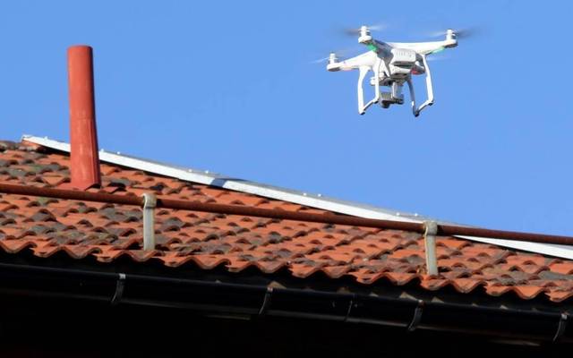
Ny och mer användarvänlig hårdvara Oculus Rift, HTC Vive och Microsoft Hololens har fått den svenska byggbranschen att hoppa på trenden med virtual reality och augmented reality, vr och ar.

Ny Teknik har tidigare berättat om hur exempelvis Skanska har utrustat vissa av sina byggnadsarbetare med Microsofts ar-glasögon i ESS-bygget i Lund.

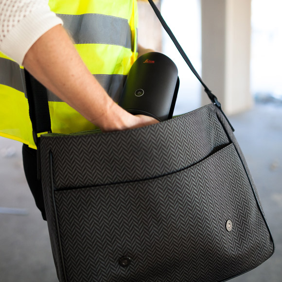
Även NCC har fått upp ögonen för tekniken, och har bland annat använt vr-glasögonen Oculus under uppförandet av SCA-huset i Mölndal.

Genom att koppla upp glasögonen till den tredimensionella datormodellen av bygget (BIM) kan personen som bär glasögonen virtuellt gå in i modellen.

Nu fördjupar NCC sin satsning på virtual reality. En särskild kompetensgrupp har tillsatts för att sprida erfarenheter, och titta på hur byggbolaget kan vidareutveckla användningen av vr.

Läs mer: 63 svenska vr/ar-bolag att ha koll på

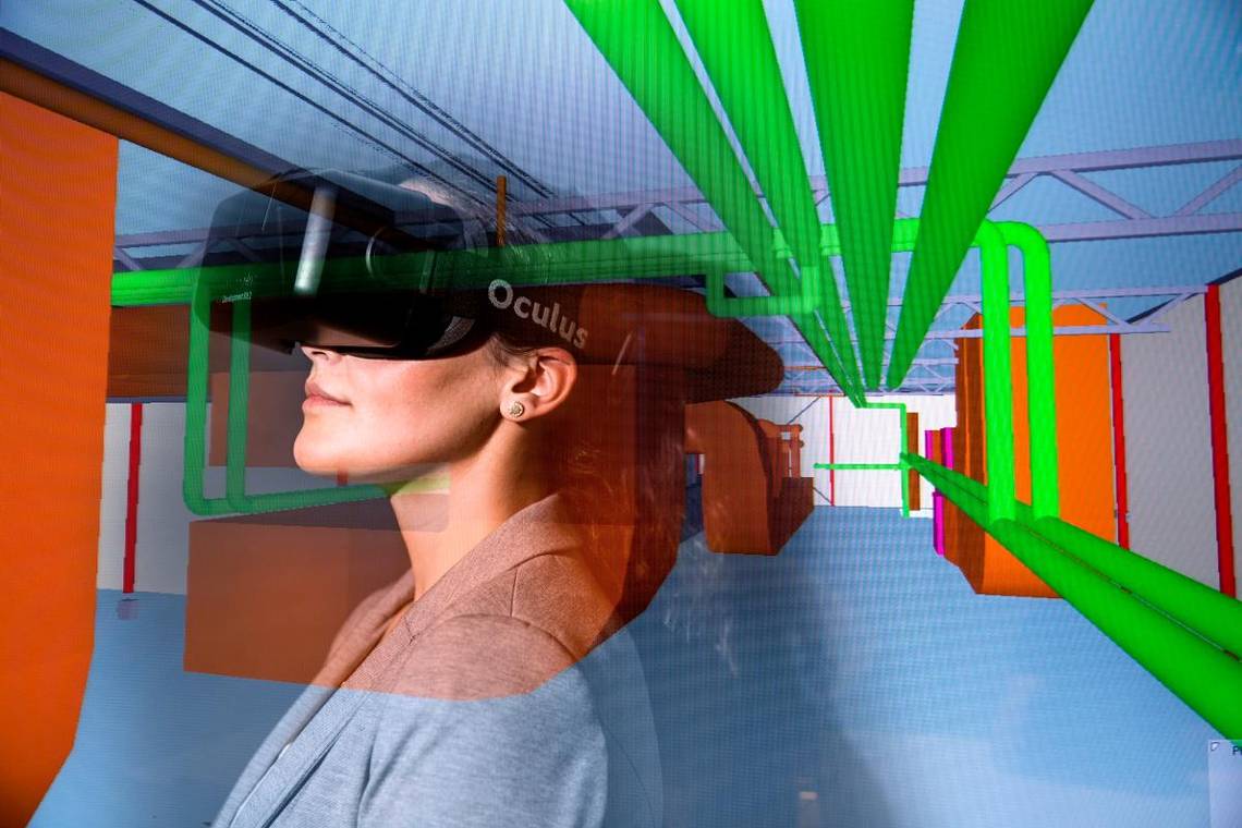
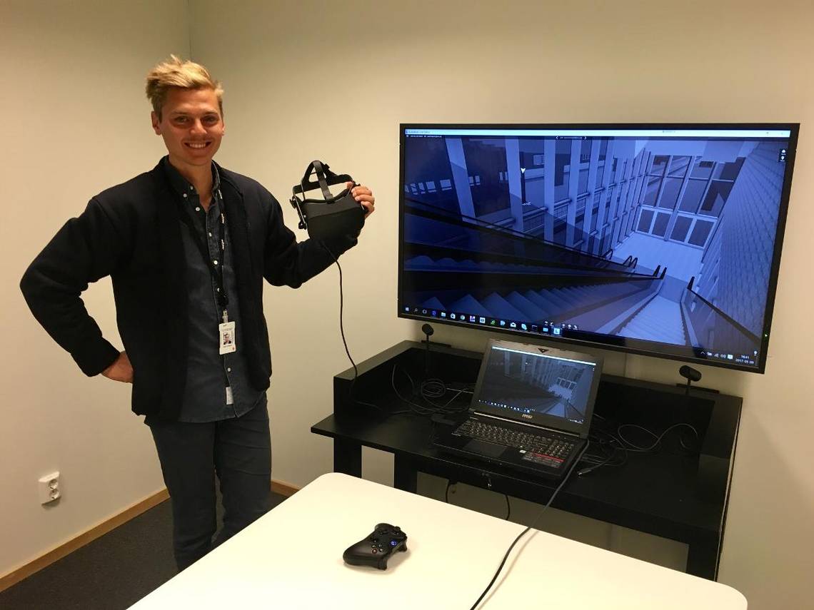
Ett färskt exempel på den utvecklingen är en vr-station på hjul som har specialbyggts inför projekteringen av Centralen, en viktig etapp av det stundande Västlänken-bygget.

Den rullande vr-stationen, utrustad med en dator och Oculus-glasögonen, har använts för att alla projektmedlemmar ska få tillgång till virtuella 3d-modeller som visar olika delar av projektet – till exempel den underjordiska pendelstation som ska byggas strax norr om Göteborgs central.

På så sätt har NCC kunnat skapa en djupare upplevelse och förståelse av vad som ska byggas.

3d-modellen av bygget uppdateras kontinuerligt, och med hjälp av vr-stationen har NCC också kunnat korta tiden som tar för nya projektmedlemmar att få en inblick i projektet.

– Det har skapat stor nytta för oss i projekteringsarbetet. Bland annat har konstnärer och arkitekter i projektet använt vr-stationen för att få en bättre rumsupplevelse. Det har hjälpt oss att kunna fatta beslut om den nya pendelstationens utformning och utseende, säger Josef Habbe, ansvarig hos NCC för VDC-arbetet i Centralen-projektet.

Bygget av SCA-huset och Centralen är högprofilerade projekt. Planerar ni att börja använda vr även i mindre byggen?

– Det är framför allt i de större projekten som vr har fått mest utrymme, men konceptet och tekniken kan också användas i mindre projekt. När vi blir bättre på att utarbeta processen för att hantera tekniken så spelar storleken på projekten mindre roll.

Vr-tekniken är dock i sin linda. Därför krävs det fortfarande en hel del arbete för att anpassa de tredimensionella BIM-modellerna till vr-programvaran.

– En utmaning är att det behövs en del handpåläggning för att få till en bra användarupplevelse. Men i takt med att tekniken går framåt och konverteringen till vr-miljöer blir enklare kommer det att krävas mindre jobb för att granska våra aktuella BIM-modeller i vr.

Läs mer: Hollywood köar för att få använda Årebolaget vr-teknik

Allt efter att tekniken optimeras kommer virtual reality också att få ett betydligt bredare användningsområde hos NCC, förutspår Josef Habbe.

– I och med att allt mer av vår framdrift och produktionsplanering utförs i 3d så blir även vr-modellen allt mer lik verkligheten. Vi ser fram emot att tekniken får allt mer produktionsfokus, och att den ger oss bättre möjlighet att bygga säkert. Det som jag tänker på då är granskning och arbetsmiljörisker, drift och underhållsaspekter.

Det här är vr och ar

Vr står för virtual reality. Då krävs glasögon eller en hjälm som fästs runt huvudet. Ar står för augmented reality, på svenska förstärkt verklighet. Det innebär att ett lager av digital information placeras över den verkliga världen. Det kan ske via särskilda glasögon eller via en skärm på en mobiltelefon.

Så arbetar NCC med VDC

VDC står för ”virtual design and construction”, och är ett NCC-koncept för att jobba med projekt som stöds av Building Information Modeling (BIM).

Kortfattat handlar VDC om att använda digitala medel – exempelvis vr-glasögon – för att det enklare att samarbeta över ämnesgränser, samt att planera och fatta beslut om pågående eller kommande projekt.

Content retrieved from: https://www.nyteknik.se/digitalisering/specialbyggd-vr-station-hjalper-ncc-att-planera-smartare-6886235.

Publicerad den Lämna en kommentar

Nya fynd från mayatiden tack vare laserteknik

Nya fynd från mayatiden tack vare laserteknik

Logotyp för TT NyhetsbyrånTT Nyhetsbyrån 2018-02-02

Experter har med hjälp av en högteknologisk laserskanner upptäckt tiotusentals gamla mayakonstruktioner som ligger dolda under tät växtlighet i djungeln i norra Guatemala.

Nya fynd från mayatiden tack vare laserteknik. © Foto: TT Nya fynd från mayatiden tack vare laserteknik.

Omkring 60 000 historiska fynd har under de senaste två åren upptäckts när den norra regionen Petén, som gränsar till Mexiko och Belize, har skannats med hjälp av laserteknik, enligt projektledaren Marcello Canuto, arkeolog vid Tulane University i USA.

Canuto beskriver fynden som en ”revolution i mayaarkeologin”.

De nya upptäckterna i det centralamerikanska landet inkluderar stadscentrum med trottoarer, bostäder, ceremoniella samlingsplatser, bevattningskanaler och fästningar.

Bland fynden finns en 30 meter hög pyramid som man tidigare trott var en kulle i Tikal, det största fyndområdet i Guatemala från den gamla mayacivilisationen. I Tikal har arkeologerna även upptäckt flera gropar och en 14 kilometer lång mur.

Mayakulturen blomstrade under åren 250-950 efter Kristus i det som nu är södra Mexiko, Guatemala och delar av Belize, El Salvador och Honduras.

Forskare tror att Mayariket hade en befolkning på omkring tio miljoner, vilket är ”många fler” än tidigare uppskattningar, enligt Canuto.

Projektet har tagit hjälp av luftburen laserteknik där ett instrument kallat Lidar fästes på undersidan av flygplan som flög fram och tillbaka över djungelområdet och skapade tredimensionella kartor, med hjälp av ljus i form av pulserande laser kopplad till ett gps-system.

Tekniken har hjälpt forskare att hitta nya platser mycket snabbare än när traditionella arkeologiska metoder används.

– Nu är det inte längre nödvändigt att hugga sig genom djungeln för att se vad som är under den, säger Canuto.

Content retrieved from: https://www.msn.com/sv-se/nyheter/vetenskap/nya-fynd-från-mayatiden-tack-vare-laserteknik/ar-BBIAOmp.

Publicerad den Lämna en kommentar

ABRIS DG Drones Capture Mapping Data in Extreme Conditions

ABRIS DG Drones Capture Mapping Data in Extreme Conditions

In anticipation of Commercial UAV Europe, we’re connecting with some of the organizations that are operating across the continent to explore how drones are being utilized for commercial purposes throughout Europe and beyond. Drone technology continues to make a major difference in terms of how professionals can and are approaching their work in this area of the world.

ABRIS Design Group, out of Ukraine, has been providing products and services in light and ultra-light aviation, aerial mapping, and land monitoring for over twenty years. We talked with ABRIS DG Lead engineer Vadim Kolesnichenko to learn more about their offerings, what makes the FLIRT different from other tools for aerial mapping, how they’ve helped their customers overcome a variety of challenges and plenty more.


Jeremiah Karpowicz: What can you tell us about ABRIS Design group? Do you focus on both products and services?

Vadim Kolesnichenko: ABRIS DG is a company that unites experienced professionals from different fields of knowledge: aircraft design and aerodynamics, control systems, technology, programming, geodesy. This is a group of professionals who are fascinated with a common goal – the creation of effective unmanned systems for aerial photography.

ABRIS DG supplies unmanned systems around the world. At the same time, we provide services of aerial photography and agricultural photography in Ukraine. Actually, during the process of providing various aerial photography services, our unmanned systems were being designed and developed. We are constantly improving our technologies, because we know our customers’ needs.


How have you been able to create value for your customers in the aerial mapping space?

ABRIS DG solutions allow users to obtain high-quality photographic material, which can be used for mapping or precision agriculture. The additional advantages are high standards of shooting quality, high productivity of our systems, minimal costs and simple preparation.

We are not limited to working with clients remotely, as we also delegate our specialists to work on-site. It allows us to provide direct support to our customers and to easily receive useful feedbacks.


Tell us about your products. What makes FLIRT different from some of the other aerial mapping tools that are currently available?

ABRIS DG products are used for different survey and aerial photography applications. The FLIRT Cetus is used for carriage of a full frame camera for a long time missions up to 3 hours each. The FLIRT Arrow is a lighter version of the FLIRT Cetus with narrowed fuselage, making it capable for hand launch. The FLIRT Iron is a metal version of the Flirt Cetus and was designed for agricultural applications.

The main idea of the FLIRT system is to bring the quality and performance of classic manned aerial photography systems to unmanned aerial systems. The FLIRT Cetus is aimed to obtain initially high-quality and well-oriented images.

The FLIRT planes can be easily adapted or supplemented by the user to solve a new task. Despite the complexity of the FLIRT design, its modularity allows to be repaired by the user.


What are some of the features and advantages of the system as a whole?

FLIRT operates the way it does because of FlightPlanner software. It interactively takes into account the features of the airplane, the camera, the lens, the actual weather in the region of the flight and the terrain. It allows users to plan a mission easily and optimally right before the flight.

As part of that system, the LuckyLaunch catapult system guarantees 100% successful aircraft take off in winter and summer conditions, and in valleys and highlands. The LuckyLaunch catapult is scalable and suitable for launching with other aircrafts as Skywalker X-8, Trimble/Delair UX-5. The LuckyBeak parachute system will ensure a safe landing even if any critical situation occurs.

The LuckyBeak is a regular reusable parachute landing system for all FLIRT aircrafts, also it serves as an emergency system on planes. In addition, it can be used as an alarm system on a wide variety of multi-rotor and fixed wing aircraft systems. The LuckyBeak’s main feature is an extremely fast canopy deployment. There were cases when the system managed to rescue an aircraft at altitude even less than 10 meters. The patented design of the LuckyBeak ensures triggering at full loss of power supply.

Another important feature of the FLIRT planes is the ability to capture a large area during one flight. This is possible because of the powerful batteries and good aerodynamics of the aircraft. A wide range of operating flight speeds (from 60 to 100 km / h) allows the system to operate even in a strong wind. The aircraft can also optimize speed by itself for these conditions.


What sorts of professionals are utilizing Skylink? How is it making a difference for them?

One of the typical applications for SkyLink is in forest monitoring during a drought. Another use is a monitoring and operational management at farming. It’s also been used quite frequently as a radio repeater.


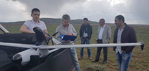
What are some of the biggest challenges you’ve helped your customers and users overcome?

It was a big challenge to start using FLIRT systems in the mountainous regions of Turkey, which we carried out with our good partners from Turkey – MapAir.

We had to simultaneously deal with rarefied air in high-altitude conditions (over 2000m), extremely high temperatures (up to 45 degrees C in the shade), extremely difficult terrain for launching and shooting, and unpropitious conditions for landing, because of plenty rocks and stones. A separate challenge was to overcome the language barrier in dealing with customers, who spoke only in Turkish. It was a test both for the technicians and for the personnel of our company.

However, as a result of this experience, ABRIS DG team has created a special custom version of aircraft for mountainous hot regions. It also allowed us to make many improvements both in the design of the aircraft and in the software.


How have you helped your customers quantify their investment in your technology?

We are constantly in contact with our customers directly or through our partners in the regions. We’re able to support customers in missions planning or even manage the aircraft that is in flight many thousands kilometers far from us.

A close dialogue with end-users is typical, which allows us to improve our solutions. We combine the trainings of our clients with the realization of their commercial tasks. We can provide our equipment and specialists. In addition, we also provide engineering services to buyers of our solutions on preferential terms. That can mean, for example, post-processing of aerial photography.


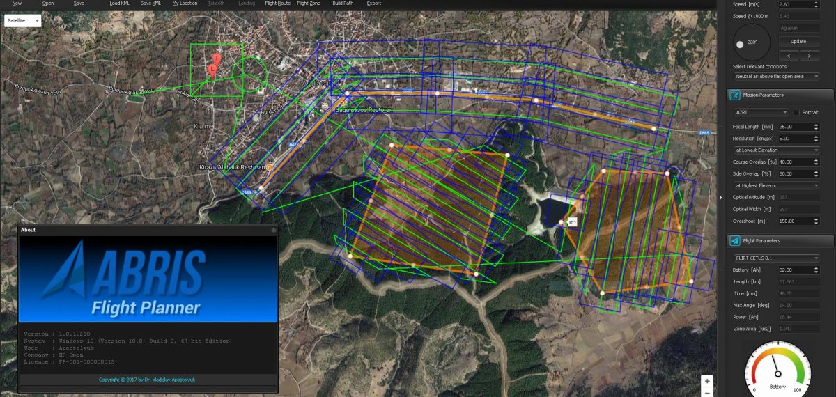
What’s the best way for someone to figure out whether or not your solutions are the right fit for their organization or project?

The most effective option is to find the solution on a practical task. ABRIS DG is always open to meet new clients needs. If the application is new, our team will be ready to test our solution in practice to show that this is a right fit for customers project.


Content retrieved from: https://www.expouav.com/news/latest/abris-dg-drones-data-in-extreme-conditions/.

Publicerad den Lämna en kommentar

Riksbyggen börjar 3d-skanna hus med drönare

Riksbyggen börjar 3d-skanna hus med drönare

Drönarteknik och 3d-kartor ska göra det lättare för Riksbyggens kunderratt planera underhål. Foto: Riksbyggen


3d-modeller från drönare ska göra det lättare för bostadsföreningar att planera exempelvis ombyggnationer, hoppas Riksbyggen. Bakom tekniken står nystartade Spotscale.

I somras kunde nyfikna Skövdebor se hur drönare hovrade över flera av stadens bostadshus. Flygningarna var en del i ett försöksprojekt som Riksbyggen genomförde tillsammans med det unga Linköpingsbolaget Spotscale.

Riksbyggen har använt drönare inom fastighetsförvaltning i flera år, bland annat för att inspektera fasader och tak. Nu har ett nytt användningsområde testats: Genom att samla in högupplösta bilder med drönare Riksbyggen och Spotscale kunnat ta fram 3d-modeller av bostadsrättföreningar.

3d-modellerna är skalenliga och visar exakt hur gårdar och fastigheter ser ut ur olika vinklar. Tanken är att modellerna bland annat ska göra det enklare för bostadsrättsföreningar att planera ombyggnationer.

De tredimensionella modellerna skapas i Spotscales molnbaserade programvara och hamnar i appen Spotinspection. I programmet kan bostadsföreningarna sedan bland annat lägga till eller ta bort föremål på bilderna.

– Det gör att man på ett mycket naturtroget sätt kan få svar på frågan om hur husen skulle se ut om man till exempel lägger till balkonger, säger Göran Danling, processansvarig Teknisk Förvaltning på Riksbyggen.

Spotscales teknik används redan av flera byggbolag, mäklare och arkitekter, bland annat. Samarbetet med Riksbyggen innebär att Spotscale tar ett steg mot ett helt nytt område: fastighetsförvaltning.

– Vi är övertygade om att det kommer att kunna bli ett viktigt segment för oss. Många är tveksamma till 3d-modeller från början, men inser sedan hur effektiv tekniken är när man bland annat ska planera för underhåll, säger Katarina Nylander på Spotscale.

Tillsammans med Riksbyggen ska Spotscale nu titta på hur man kan utveckla sin 3d-bildteknik för att göra den mer anpassad för fastighetsförvaltning.

Genom att sätta exempelvis ir-kameror på drönarna skulle det gå att skapa modeller som snabbt kan visa om hustaken har blivit skadade under vinterns snöröjning. Eller att utifrån 3d-bilderna beräkna exakt hur många tegelpannor som behövs bytas ut på ett hus.

– Det finns massor att göra framöver till exempel med fler sensorer ombord på drönaren och bildanalys. Därför är det väldigt värdefullt för oss med en stor partner som Riksbyggen. De kan fastighetsförvaltning, och deras gedigna branschkunskaper kommer att vara till stor hjälp i vidareutvecklingen av tekniken, säger Katarina Nylander.

Content retrieved from: https://www.nyteknik.se/innovation/riksbyggen-borjar-3d-skanna-hus-med-dronare-6878228.

Publicerad den Lämna en kommentar

Nya regler för drönarbilder över skog

Den 1 november kom nya regler som gör det möjligt för skogsägare att publicera drönarbilder från den egna skogen utan att söka tillstånd.

I vanliga fall krävs tillstånd från Lantmäteriet för att sprida bilder och filmer från luftfarkoster som drönare. Men det finns undantag då inget tillstånd krävs.

Det senaste undantaget från tillståndsplikten gäller bilder och filmer som tagits över skogsmark, förutsatt att de uppfyller dessa villkor:

  • Markägaren ska själv ha beställt materialet eller agerat fotograf.
  • Bildmaterialet får inte innehålla fordon, byggnader, anläggningar, verksamheter eller andra mänskliga aktiviteter, förutom sådant som tillhör skogsbruket.


Alla undantag från tillståndsplikten finns beskrivna i Lantmäteriets föreskrifter om spridningstillstånd för sammanställningar av geografisk information. Undantaget för skogsmark trädde i kraft den 1 november 2017 och ligger som en föreskriftsändring i LMFS 2017:2.

Läs mer om spridningstillstånd

Content retrieved from: https://www.lantmateriet.se/sv/Nyheter-pa-Lantmateriet/nya-regler-for-dronarbilder-over-skog/.

Publicerad den Lämna en kommentar

Terrestrial Laser Scanning in Archaeology and Cultural Heritage Management

by Carey L. Baxter, Stephen E. Jankiewicz, and Dr. George W. Calfas, U.S. Army Corps of Engineers Construction Engineering Research Laboratory
Image 1: Leica ScanStation P40 3D Laser Scanner at Mount Moriah Cemetery, Philadelphia PA. Photo by ERDC-CERL for US Department of Veterans Affairs, National Cemetery Administration.

The use of terrestrial laser scanning (TLS) for archaeological applications has escalated in recent years and this relatively new technology is altering how archaeologists are approaching the past’s material record. At the most fundamental level TLS provides extraordinarily precise three-dimensional (3D) digital surface models of moveable artifacts, buildings, site terrains, and even entire landscapes. TLS’s ability to cost effectively provide accurate and highly detailed documentary data in minimal amounts of time has largely contributed to its rising popularity (Image 1).

TLS is an automated technique that uses patterned laser light to measure surfaces and does not require physical contact with the object or feature. Once the area of acquisition and laser light density (ranging between a data point every millimeter to several centimeters) are selected, the positioning and travel time of the laser light is measured, calculated, and placed into a point cloud – an analyzed set of measured 3D points that are representative of a surface. Millions of points can be detected, accurately recorded, and processed within a short amount of time. The point clouds from multiple scans are typically stitched together into a single unified point cloud through a process called registration, which captures every aspect of the subject from all sides and angles. TLS can be directly georeferenced to known control positions and is already replacing traditional surveying instruments used to obtain geospatial measurements at archaeological field sites.

After the point cloud data is processed, it is often combined with other acquisition methods such as photogrammetry to produce realistic ultra-high resolution textured 3D digital surface models.  Additionally, some laser scanners have the built-in ability to capture digital photographs and seamlessly blend these images with the point cloud. Within the fields of archaeology and cultural heritage management, these generated 3D models are often used for basic recording of topographic conditions, documentation of artifacts, spatial analyses, monitoring and detecting damage to artifacts and buildings, and public exhibition.

TLS’s capability to greatly enhance surficial data acquisition with added time and cost benefits attracted the interest of archaeologists at the United States Army Corps of Engineers (USACE) Engineer Research and Development Center, Construction Engineering Research Laboratory (ERDC-CERL). ERDC-CERL perceive the application of this technology as an ideal opportunity to increase the United States (US) Army’s ability to properly maintain and manage its cultural resources located within military installations and are currently demonstrating the utility of TLS to inform various resource management plans.

An example of the benefits that TLS data brings over traditional site recordation is demonstrated through a project undertaken for the US Department of Veterans Affairs, National Cemetery Administration of a military section of the Mt. Moriah Cemetery in Philadelphia, Pennsylvania. A defining visual characteristic of military cemeteries that distinguish them from private or public cemeteries is the uniform appearance of the stone grave markers. Historically, military grave markers were carved and hand engraved by local stone masons, resulting in slight regional variations in stone and letter font style. Over time the style of the grave markers and lettering fonts have also evolved to the extent that a knowledgeable observer can quickly identify a stone to broad historical periods based on stylistic cues alone. Many of the military tombstones at the Mt. Moriah Cemetery, some dating back to the early 1840s, have become so degraded and weathered that they are no longer legible. The VA National Cemetery Administration plans to replace damaged stone grave markers with ones that match the original font, profile and dimension, thus maintaining the visual integrity of the cemetery sections. TLS was deployed to scan the best preserved grave markers for each historical period in order to recreate 3D fonts for replacement markers. The newly produced stone grave markers will perfectly match surrounding markers in every detail (Image 2).

Image 2: Point cloud data of a grave marker located within Mount Moriah Cemetery, Philadelphia PA. In this example the point cloud data has been enhanced with color information derived from digital photographs. Scan by ERDC-CERL for US Department of Veterans Affairs, National Cemetery Administration

TLS was also recently used to record the interior and exterior of a mid-19th century structure located within Carlisle Barracks, Pennsylvania as part of the Historic American Buildings Survey. These specific types of surveys are often conducted prior to modification of historic structures – such as refurbishing or remodeling. The building in question initially functioned as a residential farmhouse, was then modified for use as a school, and eventually served as US Army officer’s quarters. The installation managers are in the process of determining if the building should undergo renovation to serve future needs, or if the structure should be relocated and instead utilized for education, recreation, or public outreach purposes. TLS was conducted alongside more traditional surveying methods such as hand measurements and drawings. TLS data were collected in less than one-third the time and able to demonstrate that the structure is twisting as the foundation continues to settle. This detail, which was not identified by the hand measurements, is critical information needed for judging the structural stability of the building and determining the feasibility of continued use of the site.

Finally, TLS was similarly used to record and analyze engineering characteristics of World War II era structures located within Fort Campbell, Kentucky. These types of structures are fairly common on military installations across the US and are creating widespread concerns for installation managers. As with many older structures, they tend to be deemed energy inefficient when compared to modern building standards. Their wall structure, however, is not robust enough to allow for the adequate addition of traditional insulation to increase the R-value (a measure of thermal resistance) of the building. To help the US Army meet current green initiatives, ERDC-CERL is testing a new insulation technique to retroactively increase the insulating property of a building requiring minimal structural modifications. In this instance, TLS data were overlaid with thermal camera images to create before and after comparative data sets. The generated 3D models will be used to evaluate the performance of the prototype insulation (Image 3).

ERDC-CERL plans to continue to develop and apply TLS to assist the US Army with more efficiently operating, maintaining and managing its cultural resources located within military installations. The applications for this technology appear endless and only time can reveal the true value of this technology.

Image 3: Point cloud data of WWII era structure located within Fort Campbell, KY. Scan by ERDC-CERL for US Army, Fort Campbell Department of Public Works.

About the Authors 

Carey L. Baxter has worked as an archaeologist for the United States Army Corps of Engineer’s Engineer Research and Development Center, Construction Engineering Research Laboratory (ERDC-CERL) in Champaign, Illinois since 2004.  She specializes in geospatial and geophysical data collection and analysis.

Stephen E. Jankiewicz, RPA is a doctoral student at the University of Illinois at Urbana-Champaign (UIUC), and a Graduate Research Fellow at the United States Army Corps of Engineer’s Engineer Research and Development Center, Construction Engineering Research Laboratory (ERDC-CERL) in Champaign, Illinois.

Dr. George W. Calfas, RPA is the Senior Archaeologist and Program Manager at the United States Army Corps of Engineer’s Engineer Research and Development Center, Construction Engineering Research Laboratory (ERDC-CERL) in Champaign, IL and adjunct professor at the University of Illinois at Urbana-Champaign (UIUC)


Content retrieved from: https://www.rdmag.com/article/2017/08/terrestrial-laser-scanning-archaeology-and-cultural-heritage-management.

Publicerad den Lämna en kommentar

NEW Leica BLK360

Leica BLK360 Laser Scanner

The revolutionary Leica BLK360 laser scanner has been announced by Leica Geosystems.

This amazing laser scanner is small enough to fit in your hand but powerful enough to deliver full 360° reality capture in under 3 minutes.

Leica have developed the BLK360 to bridge the gap between scientific-grade 3D laser scanners and emerging camera and handheld technologies.

This is the next generation of laser scanner. It empowers every AEC professional to realize the benefits gained by incorporating high resolution 360° imagery and 3D laser scan data in their daily work.

FEATURES & SPECS:

  • Smaller and lighter than any other laser scanner
  • Unit measures: 101mm wide by 152mm high and weighs under 1Kg
  • Full 360° reality capture in under 3 minutes
  • 360,000 pts / second laser scan
  • 15 Mpixel 3-camera system
  • HDR, LED flash support
  • Longwave Infrared panorama image
  • Thermal image overlay, thermal sensitivity <50mK
  • Measuring pre-sets point density @7.5m
  • Distance range 0.5 – 60 metres
  • Range precision <4mm @ 15 metres
  • Angular accuracy <0.2 mrad
  • 64 GB internal memory (equivalent to approx 70 full dome recordings)
  • Built in IMU with auto tilt and position tracking
  • LED light guide with 360° visible status indication
  • GEB112 Battery (up to 50 full domes recordings)
  • Compatible with Autodesk design software

MEASUREMENT WORKFLOW:

Options to transfer data from tablet to the office:

  • WLAN with 360° connectivity to iPad Pro
  • Flash Drive
  • Cloud storage services

The Leica BLK360 will be released worldwide in Autumn 2017 at an estimated price of $15,990 USD. (release date TBC)

Content retrieved from: http://globalsurvey.co.nz/shop/solutions/surveying-gis/laser-scanner/leica-blk360/.