Publicerad den Lämna en kommentar

UKspace ‘manifesto’ recommends post-Brexit UK GNSS

UK and EU referendum

GPS World graphic

A new post-Brexit GNSS “must be secured,” according to the UKspace trade association. UKspace on Nov. 21 published its manifesto for a future British government to consider, actions that will enable Britain to compete in
the “new space race.”

Among the recommendations is a satellite system to provide navigation services.
“The UK’s post-Brexit participation in a new global satellite navigation system must be secured, whether through ESA or a sovereign capability,” the manifesto said.

“The 2019 Spending Review committed to continuing to provide £191M of funding to support Brexit-related activities ‘including the development of a UK Global Navigation Satellite System option and delivering business stability for company law and audit.’

“Following this initial design phase, the estimated cost of the programme is £5B. This needs to be reflected in long-term budget lines to sustain key precision, navigation and timing skills in the industry.”

Other topics in the manifesto include increased funding for the European Space Agency (ESA), establishment of a national space program, continuing to partner on Copernicus, and funding for the new National Space Council.

Publicerad den Lämna en kommentar

US efforts pointing to coherent, resilient PNT architecture

DoT remarks follow China announcement on “comprehensive PNT”

The U.S. Department of Transportation “…is seeking the best solutions to ensure that America has a combination of  PNT [positioning, navigation and timing] systems which, when used together, will be difficult to disrupt” according to remarks made at a recently concluded conference.

Diana Furchtgott-Roth (Photo: USDOT)

Diana Furchtgott-Roth

Diana Furchtgott-Roth is the department’s Deputy Assistant Secretary for Research and Technology. She made the comments during a keynote address at the Royal Institute of Navigation’s annual conference in Edinburgh mid-November.

Trained as an economist, Furchtgott-Roth noted that Edinburgh was the home of Adam Smith who in the 1700s referred to the efficiency of free markets as an “invisible hand” guiding economies. She regularly referred to GPS as “the invisible hand” guiding individuals, transportation, and technologies across the globe.

Citing GPS as a “one of the great and heroic systems of our times,” she also acknowledged wide and generally unconscious reliance on GPS signals, and its vulnerabilities. “A lot of the work in research and technology at the Transportation Department…assumes the existence of GPS. It assumes that GPS will continue to work, sight unseen, without interference.”


A dedicated GPS-only receiver “sounds as outdated as a pager.”


While PNT is essential now, she said, it will be even more important in the future as it becomes essential for even more safety applications.

“Public confidence in these will be critical. People will not be comfortable getting into an automated vehicle or with platooning driverless trucks heading down the highway if they think that their invisible hand is not reliable and that their GPS might be spoofed.”

As part of this, development and adoption of a wide variety of space-based, terrestrial, and self-contained navigation sensors must be deployed and widely adopted. A dedicated GPS-only receiver, she said, “sounds as outdated as a pager.”

She also echoed the theme of protecting frequencies, toughening receivers, and augmenting GPS signals as a way of achieving greater PNT resilience.

The department let a contract in November for demonstration of 11 technologies that could serve as a GPS augmentation/backup system. Furchtgott-Roth said, “This effort will inform implementation of a system that by law is required to be terrestrial, wireless, have wide area coverage, be difficult to disrupt, and be capable of expansion to provide positioning and navigation services.”

Departing from her prepared script, she added, “The Department of Transportation hopes to come to a decision by next May. Then we will get together with the Defense Department and the Department of Homeland Security and chose a technology or combination of technologies… And then we hope that our Congress will allocate funds to purchase this equipment. Our top priorities are national and economic security. We cannot have GPS be a single point of failure for transport and other critical infrastructure.”

The United States published its National PNT Architecture Study in 2008 citing the need for an integrated and resilient approach. Despite its call for use of multiple phenomenologies and an implementation plan signed several years later little has been done as of yet now.

Furchtgott-Roth’s comments came roughly a month after a Chinese representative to a Stanford symposium that here nation was developing a national “comprehensive PNT” after the fashion of what was called for in the U.S.’s 2008 study.

Her prepared remarks are available here.

Publicerad den Lämna en kommentar

Geodata.se – Nyhetsbrev nr 8 -2019

Nationella geodatastrategin och digitaliseringen av samhällsbyggnadsprocessen

Fredag den 13 december, kl. 12.00-13.00, bjuder Lantmäteriet in till webbsänt lunchseminarium för att informera om arbetet med den Nationella geodatastrategin och pågående aktiviteter i Geodatarådets handlingsplan 2019-20, samt hur långt vi har kommit i arbetet med smartare samhällsbyggnadsprocess. Du deltar i webbsändningen via denna länk (öppnas i nytt fönster).

Inspire – fortsatt stort fokus på prioriterade datamängder

EU-kommissionen har under de senaste åren varit tydliga med att medlemsstaterna måste förbättra genomförandet av Inspire för att undvika ett överträdelseärende. För Sveriges del rör det sig i ett första skede om ca 100 prioriterade datamängder som var och en ska redovisas med metadata, en visningstjänst samt en nedladdningstjänst. De datamängder som omfattas är framför allt datamängder som redovisas vid uppföljning av olika miljödirektiv, exempelvis data om buller, luftkvalitet eller data om skyddade områden.

Arbetet med de prioriterade datamängderna har redovisats vid ett antal uppföljningsmöten under året och framdriften i arbetet har varit bra. Den 30 oktober var dock utfallet i INSPIRE Geoportal gällande de prioriterade datamängderna sämre än planerat. Metadata om 68 prioriterade datamängder, 10 nedladdningstjänster och 58 visningstjänster fanns publicerade. Målsättningen var att ha närmare 100 datamängder publicerade och endast ett fåtal prioriterade datamängder kvar att åtgärda under november och december.

I Geodataportalen var utfallet betydligt bättre än i INSPIRE Geoportal och där var metadata om 83 prioriterade datamängder, 78 nedladdningstjänster och 79 visningstjänster publicerade.

En stor bidragande orsak till det sämre utfallet i INSPIRE Geoportal är problem med validering av datamängderna inför publicering. Nya valideringsverktyg är under framtagande och under pågående utveckling av EU. Förändringar har skett kontinuerligt vilket medfört stora svårigheter för medlemsstaterna att kvalitetssäkra metadata och tjänster inför publicering.

Lantmäteriet och de elva berörda informationsansvariga myndigheterna arbetar för närvarande med att lösa dessa problem och det förs även en dialog med ansvariga för INSPIRE Geoportal på EU-nivå. De prioriterade datamängderna ska vara tillgängliga i december 2019. Under 2020 ska övriga datamängder som omfattas av Inspire vara tillgängliga och därefter tar fortsatt förvaltning vid.

Mer om INSPIRE går att läsa på EU:s hemsida om INSPIRE (öppnas i nytt fönster) och på geodata.se (öppnas i nytt fönster).

Under 2019 har det varit ett extra stort fokus på arbetet med de prioriterade datamängderna. Lantmäteriet har samordnat arbetet och följande elva informationsansvariga myndigheter har medverkat.

  • Havs- och vattenmyndigheten
  • Jordbruksverk
  • Lantmäteriet
  • LFV
  • Länsstyrelsen
  • Myndigheten för samhällsskydd och beredskap, MSB
  • Naturvårdsverket
  • Statistikmyndigheten SCB
  • Sveriges geologiska undersökning, SGU

Nyhet från geodata.se, orginal inlägg

Publicerad den Lämna en kommentar

Ericsson verifies 5G coverage with Rohde & Schwarz drone

Photo: Rohde & Schwarz

Photo: Rohde & Schwarz

Test and measurement specialist Rohde & Schwarz has supplied mobile network testing tools used in drone-based network coverage, performance and operation tests managed by Ericsson, a global leader in network infrastructure.

Testing mobile coverage. A project team based in Jorvas, Finland, and led by Ericsson’s 5G Readiness Program RAN Technical Lead Richard Wirén, has developed— together with Centria University of Applied Sciences — a novel system for testing cellular mobile network coverage.

The new system uses mobile network-testing scanners and smartphones from Rohde & Schwarz mounted on a drone that can be programmed to execute automatic tests with considerable flexibility, for example for precise route selection and drone speed control.

This solution is especially valuable for industrial use cases. It also has the advantages over traditional walk and drive tests by providing unprecedented repeatability and positional accuracy with the ability to verify beamforming and map coverage in 3D.

Drone-mounted scanner. The R&S TSMA6 network scanner is mounted on a drone and is able to simultaneously verify important LTE and 5G NR coverage metrics such as reference signal received power (RSRP) and signal-to-interference-plus-noise ratio (SINR) in accordance with 3GPP standards.

When combined with the R&S QualiPoc Android smartphone-based optimizer, IP trace, application quality of service (QoS) metrics such as serving cell parameters are possible. The solution currently uses LTE user equipment (UE) but will soon be further developed to include 5G UEs such as the Samsung S10 5G.

The drone can be programmed to follow an exact three-dimensional route.

Repeatable tests. More than 20 successful measurement flights conducted so far have shown the solution procedure and results to be extremely repeatable. The drone flights were of various duration, altitudes and routes, depending on the test case.

Control, authentication and air traffic control are considerable challenges to the development of robust drone-based solutions. In this new system they are conducted over cellular networks, eliminating the requirement for line-of-sight connection between the drone and its pilot.

The unique procedure enables unprecedented 3D accessibility, positional accuracy and repeatability of the testing.

It also opens up new possibilities to ensure end-user QoS for demanding 5G use cases such as industry 4.0, automotive and public safety, Rohde & Scwarz said.

5G New Radio. The deployment of 5G New Radio (NR) brings new applications of cellular networks for subscribers, government and industry. It also makes the verification of the correct coverage, performance and operation of networks more critical, increasing the demand for accuracy and accessibility in traditional field network tests.

“For 5G to realize its promise, field verification of operation and quality is essential, and this development is a pioneering way to ensure our customers receive the network performance they require,” said Richard Wirén, 5G Readiness Program RAN Technical Lead from Ericsson. “We are delighted to utilize test solutions from Rohde & Schwarz that have proven themselves very reliable and are excited that we now have access to solutions based on commercially available 5G NR UEs such as the Samsung S10 5G.”

“We are delighted to combine our industry-leading mobile network testing know-how with Ericsson’s long tradition of network innovations to ensure the delivery of end-user Quality of Experience as 5G NR becomes a reality,” said Hanspeter Bobst, vice president of mobile network testing for Rohde & Schwarz.

Ericsson and Rohde & Schwarz are collaborating with Tampere University and Centria University of Applied Sciences, and the project forms part of the Business Finland 5G FORCE program.

Future developments will focus on testing critical 5G applications such as public safety and machine-type communications for Industry 4.0, extending the frequency to extremely high frequencies of the mmWave bands and testing in an urban environment.

Publicerad den Lämna en kommentar

Royal Gardens get precise imagery with Spectra Precision

Photo: Spectra Precision

Photo: Spectra Precision

Verified photomontages for UNESCO World Heritage sites achieves accuracy with Spectra Geospatial SP80

Verified photomontage is an important planning tool to envision how proposed surrounding development plans would affect UNESCO World Heritage sites. Verified photomontage demands the best accuracy for the best visualization to determine what a development may look like to a person standing at the photographic viewpoint.

For MS Environmental (MSE), selected to provide verified photomontage for multiple UNESCO World Heritage sites, including in the UK Royal Botanical Gardens at Kew and the City of Bath, the Spectra Geospatial SP80 GNSS receiver enabled the highest quality visualization.

“The one-centimeter accuracy delivered by the SP80 is essential,” said Mike Spence, a verified photomontage specialist and founder of MSE. “The highest level of accuracy in the relationship between the actual camera location and the 3D model camera gives confidence in the visualization. In addition, The SP80 offers both simplicity and a robust design though it’s taken a few knocks over the years, it gives us the confidence we can use the equipment anywhere in the world and get the best results.”

At Kew Gardens, MSE was commissioned to produce accurate visualizations of views from within the UNESCO World Heritage Site. There was concern about development proposals for tall tower blocks in west London and how these might affect historic views from Kew Gardens.

The work culminated in a public inquiry, where evidence was presented that showed how views would change as a result of the proposed development. “Without the level of accuracy provided by the SP80 together with a transparent technical methodology it would have been unclear precisely how these historic views would change,” Mike Spence said.

At the UNESCO World Heritage City of Bath, the Bath and North East Somerset Council commissioned MSE to produce technical photography from strategic views around the World Heritage City to show how development proposals would affect strategic views across the city.

Publicerad den Lämna en kommentar

High-endurance VTOL UAV the aim of GE, Hybrid Project

GE Aviation and Hybrid Project team to provide commercial high-endurance vertical takeoff and landing (VTOL) UAV, with Auterion and GE Aviation providing comprehensive integration of ground, cloud and airborne components

GE Aviation has teamed with Hybrid Project to provide a VTOL UAV designed for high-endurance commercial applications at scale. Flight testing is underway, with commercial availability targeted for the first quarter of 2020.

The agreement enables Hybrid Project’s 35-pound hybrid-powered SuperVolo VTOL UAV with a full stack airborne computing hardware platform, flight and safety management, and integration from GE Aviation and Auterion.

GE Aviation’s computing platform enables flight control and airborne computing power at the edge while maintaining an independent and authoritative safety controller. Auterion’s Enterprise PX4 operating system resides on the vehicle, in the cloud, and the ground station.

The integration is the result of an agreement announced earlier this year between GE Aviation and Auterion to provide all-in-one hardware and software platform for commercial drones.

The SuperVolo UAV. (Photo: Ben Herndon/Hybrid Project)

The SuperVolo UAV. (Photo: Ben Herndon/Hybrid Project)

“The combination of Hybrid Project’s SuperVolo airframe, GE Aviation’s computing platform, and Auterion’s software stack enables an all-in-one solution that readily scales for commercial applications,” said Matt Vacanti, product leader, Avionics Systems for GE Aviation. “A highly integrated system is critical to achieving scalable commercial UAV operations.”

Hybrid Project’s SuperVolo has been designed from the ground up with an emphasis on endurance flight, ease of maintenance, and modularity. The combined system is comprised of technologies and services which have the capability to enable commercial operations in complex environments while meeting regulatory and mission outcomes.

“This collaboration, and the combined solution, will increase commercial operator flexibility, efficiency, and overall performance to a level not previously available in its class,” said Ryan Pope, co-founder of Hybrid Project.

Auterion’s Enterprise PX4 software is built on top of open software standards that are supported by a global developer community. Auterion’s enterprise software also provides the infrastructure enabling online workflows, compliance monitoring, and enterprise fleet management. “With Auterion software, the Hybrid Project SuperVolo flies farther, safer, and more efficiently, unlocking new BVLOS capabilities and missions that were previously not possible before commercial drones of this class were available,” said Kevin Sartori, co-founder of Auterion.

Publicerad den Lämna en kommentar

QGIS Server is ready for the new OGC API for Features protocol.

The new OGC API for Features (OAPIF) (also formerly known as WFS3) is one of the first protocols of the new generation of OGC web services and we are happy to announce that QGIS Server is ready to serve data following the specifications of this new protocol.

A lot of work has been going on during last summer to make sure QGIS Server was ready to support the new family of REST APIs, the underlying architecture allows in fact to expand QGIS Server API capabilities with any kind of new API that will be available in the future.

The new API is very similar to the well known WFS, but it also comes with a distinct set of features like content negotiations, REST actions, HTML templates, JSON as a first class citizen, self-documentation of the API (following OpenAPI specifications) and a preliminary implementation (the specifications are not yet finalized) of the simple transactions.

The new API is already in the QGIS Server documentation, it only misses the transaction part because the specifications are not yet final and we don’t want people start relying on an API that is probably going to change quite soon.

The vast majority of this new development has been possible thanks to the volunteer work of our core developers but we also wish to thank OSGeo and QGIS sustaining members and donors for funding a substantial part of the following activities:

OPENAPI validation (completed)
Online demo (TODO)
CI validation/ OGC CITE (started)
Expose Schema (completed)
Simple Transactions (completed)
Returned fields filter (completed)
Documentation (completed except for transactions)
JSON performance comparison with WFS (TODO)
Time filter support (completed)

Enjoy the new API and beware that this is only the first of a brand new series of OGC APIs that will make much easier for users to interact with data and for developers to create applications that consume those data.

Text provided by Alessandro Pasotti (QGIS core developer)

Nyhet från QGIS, orginal inlägg

Publicerad den Lämna en kommentar

World-renowned PNT expert David Last presumed lost at sea

Professor Emeritus David Last.

Professor Emeritus David Last.

Just before 13:00 GMT on Monday, a private plane piloted by David Last, former president of the Royal Institute of Navigation, disappeared from radar and hit the sea approximately two miles off the coast of Wales.

On-going search and rescue efforts have recovered pieces of wreckage and personal effects.

“Last was one of the most respected and well-loved figures in the worldwide positioning, navigation, and timing community. His loss creates a hole that cannot be filled,” said Dana Goward, president of the Resilient Navigation and Timing Foundation. “David was a close personal friend. Our grieving will not be brief.”

According to BBC News, the search for the missing plane and its pilot off the Welsh coast resumed on Tuesday. North Wales Police said the light aircraft was flying from Caernarfon Airport to the Great Orme, Llandudno, and back on Monday when it disappeared. There were no other passengers and officers were supporting the missing pilot’s family.

The Maritime and Coastguard Agency said the search has resumed around Puffin Island, near Penmon, Anglesey. A plane carrying a sonar technology camera is searching the area as well as a lifeboat, helicopter and coastguard teams on foot.

David Last was a UK consultant engineer specializing in radio navigation and communications systems, professor emeritus at the University of Bangor, Wales, and past president of the Royal Institute of Navigation.

He also was a member of the expert panel and co-author of the January 2018 Blackett Report.

Publicerad den Lämna en kommentar

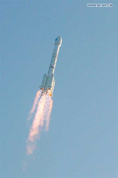
China launches two MEO BeiDou-3 satellites

China sends two BeiDou satellites into space a Nov. 23. (Photo: Guo Wenbin/Xinhua)

China sends two BeiDou satellites into space a Nov. 23. (Photo: Guo Wenbin/Xinhua)

China launched two satellites of the BeiDou Navigation Satellite System (BDS) into space from the Xichang Satellite Launch Center in Sichuan Province at 8:55 a.m. Saturday, Nov. 23.

Launched on a Long March-3B carrier rocket and the Yuanzheng-1 (Expedition-1) upper stage attached to the carrier rocket, the two satellites have entered their planned orbits. They are the 50th and 51st satellites of the BDS satellite family.

The two medium earth orbit (MEO) satellites are also network satellites of the BeiDou-3 system.

The two new satellites, the carrier rocket and Yuanzheng-1 were all developed by the Innovation Academy for Microsatellites of the Chinese Academy of Sciences and the China Academy of Launch Vehicle Technology under the China Aerospace Science and Technology Corporation.

The launch was the 319th mission for the Long March series carrier rockets.

Publicerad den Lämna en kommentar

C-V2X module powers smart truck project at Shanghai Port

Quectel Wireless Solutions has partnered with SAIC Motor, Shanghai International Port and China Mobile to install its C-V2X modules on trucks to conduct smart truck trials for the shipping industry.

Developed by SAIC Motor, the heavy smart trucks are powered by advanced technologies, including 5G, V2X and AI, to achieve 5G L4-level intelligent driving at the port. Each truck has been equipped with “senses” to detect the external environment and cope with unexpected situations such as crosswinds, obstacles in the road or pedestrian traffic. After arriving at the destination, the vehicles can also dock in target locations.

Photo: Quectel

Photo: Quectel

Quectel C-V2X modules AG15 were integrated in the trucks to help identify and communicate with roadside units such as gates and traffic lights, greatly improving driving safety and efficiency.

According to McKinsey and Company, the automation of ports has proved safer, more cost-effective and efficient than conventional ones. However, the adoption of automation remains slow compared to other sectors. One reason is the high upfront costs associated with automation and difficulties in ensuring effective operations.

The introduction of 5G provides port owners with an unprecedented opportunity to embrace automation to reduce costs by 25-55% and raise productivity by up to 10-35%, according to the same report.

Modules, such as the Quectel C-V2X portfolio, offer even more significant cost-effectiveness and flexibility than conventional forms of investment in automation as they can be custom-installed to meet automakers’ or port authorities’ requirements.

Additionally, Quectel’s AG520R module integrating LTE+C-V2X technologies has supported over 30 automotive customers in product design. The 5G+C-V2X module AG550Q is currently under development and compatible with AG520R in both HW/SW, ensuring a smoother migration from LTE to 5G, which means that the future of automation is now just a module away.