Publicerad den Lämna en kommentar

Aceinna drives to CES 2020 with tiny GNSS/INS module

Module designed for developers creating guidance and navigation systems for autonomous vehicles, robots, drones, industrial, construction and agricultural machinery

Aceinna launched its OpenRTK330L at CES 2020, the massive annual consumer electronics show taking place Jan. 7-10 in Las Vegas. The company is located at Booth 6738, CES North Hall, Automotive Pavilion.

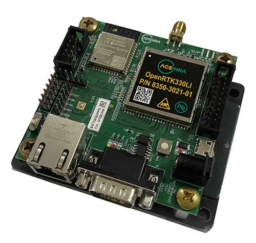
OpenRTK330L is a low-cost,high-performance triple-band RTK/GNSS receiver with built-in triple redundant inertial sensors. Designed to replace the expensive and bulky precision RTK/INS systems used in today’s autonomous systems, the compact navigation solution meets the challenging performance, reliability and cost requirements of the automotive market along with the needs of robot, drone, construction and agriculture systems, Aceinna said.

Image: Aceinna

Image: Aceinna

Demonstration Drive

Aceinna is demonstrating its GNSS/INS-based autonomous vehicle localization technologies on its test vehicle, which drove from Silicon Valley to Las Vegas.

The company is recording live drive-test data that demonstrates how its precision positioning solutions provide high accuracy and reliability. Precision location capability is critical for all levels of autonomous driving.

OpenRTK330L includes a triple-band RTK/GNSS receiver coupled with redundant inertial sensor arrays to provide cm-level accuracy, enhanced reliability, and superior performance during GNSS outages.

The OpenRTK330L integrates a precise 2 Degree/Hour IMU to offer ten to 30 seconds of high accuracy localization during full GNSS denial. This enables autonomous system developers to safely deliver highly accurate localization and position capabilities in their vehicles at prices that meet their budgets.

Image: Aceinna

Image: Aceinna

OpenRTK330L’s embedded Ethernet interface allows easy and direct connection to GNSS correction networks around the world. OpenRTK330L’s CAN bus interface allows simple integration into existing vehicle architectures.

The multi-band GNSS receiver can monitor all global constellations (GPS, GLONASS, BeiDou, Galileo, QZSS, NAVIC, SBAS) and simultaneously track up to 80 channels. The module has RF and baseband support for the L1, L2 and L5 GPS bands and their international constellation signal equivalents.

The inertial measurement unit and dead reckoning function contains a total of 9 accelerometer and 9 rate gyro channels based on Aceinna’s unique triple redundant six-axis IMU array. By integrating a triple-redundant IMU array, the OpenRTK330L is able to recognize and utilize only valid sensor data, ensuring high-accuracy protection limits and certifiability under ISO26262 standards.

Open Navigation Platform

Image: Aceinna

Image: Aceinna

“The combination of a triple-band GNSS receiver and a high-precision IMU has enabled us to make a remarkably accurate, small, reliable and cost-effective GNSS/INS solution,” said Mike Horton, CTO of Aceinna. “The OpenRTK Precise Positioning Engine optimizes satellite tracking and high RTK fixes rates while integrating seamlessly with Aceinna’s open-source, developer-friendly Open Navigation Platform.”

The Open Navigation Platform allows custom embedded application development on top of Aceinna’s positioning engine and dead-reckoning algorithms. Autonomous solution developers have full access to all resources on the OpenRTK330L module including the GNSS receiver measurement data, IMU measurement data and all interfaces.

The OpenRTK330L GNSS receiver supports GPS (L1 C/A, L2C and L5), GLONASS (L1OF, L2OF), BeiDou (B1I, B2I), GALILEO (E1, E5a, E5b, E6) QZSS (L1 C/A), and NAVIC. The IMU sensor array includes a triple-redundant, 3-axis MEMS angular rate sensor, and a triple-redundant, 3-axis MEMS accelerometer.

Hardware also includes, Ethernet, UART, SPI and CAN interfaces for versatile integration into a host system. Additional specifications include operating temperature range of -40C to +85C, and qualification to standard automotive shock and vibration levels.

Detailed information and data sheets are available.

Publicerad den Lämna en kommentar

Geodata.se – Nyhetsbrev nr 1 – 2020

Inbjudan till Geodataseminarium

Lantmäteriet och Geodatarådet välkomnar till seminarium torsdag den 30 januari kl. 10-15 på Norra Latin i Stockholm.
Seminariet fokuserar på samverkan och samhällsnyttor med geodata. Under dagen får du bland annat ta dela av:

Status i Geodatarådets handlingsplan och information om uppdatering av den Nationella geodatastrategin.

Hur läget är i Lantmäteriets regeringsuppdrag – Smartare samhällsbyggnadsprocess och den pilot som genomförts under hösten, hur ser tidplanen ut?

Du får också ta del av vad slutrapporterna – Grunddata samt Säker och effektivt informationsutbyte, säger och Myndigheten för Digital Förvaltning:s erfarenheter och tankar kring förmågan att utför uppdrag i samverkan.

Program

09.30-10.00

Registrering och kaffe

10.00-10.15

Med samverkan och geodata skapar vi samhällsnyttor

10.15-10.45

Status i Geodatarådets handlingsplan 2019-2020 och arbetet med att uppdatera den Nationella geodatastrategin

10.45-11.15

Vad säger slutrapporten i regeringsuppdragen – Säker och effektiv tillgång till grunddata samt ett säkert och effektivt elektroniskt informationsutbyte inom den offentliga sektorn?

11.15-11.40

Lantmäteriets regeringsuppdrag Digitalt först– En smartare samhällsbyggnadsprocess, vart befinner vi oss?

11.40-12.00

Samverkan en vinnande framdriftsfaktor?

12.00-13.00 

Lunch

13.00-13.30

Geodata som räddar liv

13.30-14.00

Örebros digitala tvilling proppfull med geodata

14.00-14.20 

kaffe

14.20-14.45

Gruppdiskussioner

14.45-15.00

Summering och avslut av dagen

Vi avslutar dagen med inspirerade föredrag samt en gruppdiskussion med frågor som du ger ditt svar på via din mobil. Läs mer och anmäl dig här (öppnas i nytt fönster).

Positiv stämning på Inspire arbetsgruppsmöte

Den 17 december genomfördes ett Inspire arbetsgruppsmöte i Sveriges Kommuner och Regioners mycket fina möteslokaler i Stockholm. Syfte med mötet var att sammanfatta arbetet med de prioriterade datamängderna och genomföra en uppstart inför arbetet med Inspire under 2020.

Två representanter från Miljödepartementet var på plats på mötet och 18 av de 24 informationsansvariga myndigheterna deltog. Dessutom bidrog två av de sex myndigheter som inte var på plats med material till mötet och från Sveriges Kommuner och Regioner deltog en person.

Lantmäteriets divisionschef för Geodata, Anders Sandin, och Gunilla Blomquist från Miljödepartementet inledde mötet och båda gav en positiv syn på hur arbetet med prioriterade datamängder genomförts. Båda framhöll vikten av fortsatt bra samarbete mellan inblandade aktörer. Inspire ska enligt gällande tidplan vara genomfört till oktober 2020 och Gunilla passade på att påminna om att Inspire därefter ska fortsätta förvaltas på ett bra sätt.

Under dagen presenterade respektive informationsansvarig myndighet status och planer gällande sitt genomförande av Inspire. Mötet avslutades med att Hannes Reuter från Eurostat, via Skype från Luxemburg, informerade om nyttjande av data på europeisk nivå.

17dec2019_Inspire_AG_deltagarna_lyssnar-500x300.jpg
17dec2019_Jordbruksverket_Inspire_AG_stockholm-600x500.jpg 17dec2019_SMHI_Inspire_AG_stockholm-600x500.jpg
Nyfikna deltagare på Inspire arbetsgruppsmöte. Bastian Berlin, Jordbruksverket, presenterar planer för 2020. Tomas Funquist, SMHI, presenterar status.

Mer om fokus på de prioriterade datamängderna går att läsa om i 2019 års Geodata.se – Nyhetsbrev 3 och 8.

Nyhet från geodata.se, orginal inlägg

Publicerad den Lämna en kommentar

Some airlines miss ADS-B Jan. 1 deadline

Photo: icholakov/iStock Editorial/Getty Images Plus

Photo: icholakov/iStock Editorial/Getty Images Plus

BahamasAir has missed the U.S. deadline for the new ADS-B mandate and is now forbidden from flying certain three of its four jets in United States airspace. The airline said it has adjusted its aircraft deployment accordingly, reports Forbes.

The U.S. Federal Aviation Administration mandated in 2010 that aircraft be equipped with hardware to use NextGen, a satellite-based air traffic control management system, to replace traditional ground radar technology. This step of the transition requires aircraft to have Automatic Dependent Surveillance-Broadcast Out (ADS-B) capability either at time of manufacture or retrofitted with a kit.

BahamasAir was unable to equip three of its Boeing 737-500s with ADS-B before the Jan. 1 deadline, so those aircraft have been taken off the routes it flies to Florida. It has one 737-700 and five ATR regional airliners that have ADS-B, and is using those aircraft for Florida. It also leased some planes to meet holiday season demands.

The airline says it’s maintaining its full schedule with no changes and the old 737s should be fixed in the next few months. Meanwhile, the agency has granted an exemption to the government of Canada for two of its old airframes.

Canadian  Changes

The Royal Canadian Air Force operates four Challenger 601 business jets to take government and military officials on shorter flights in the U.S. and Canada. Two of those jets are too old to receive the ADS-B upgrade, so the FAA has said it will be allowed into U.S. airspace but may not get the most convenient routing from air traffic control, according to AVWeb. The FAA does have a process to waive the ADS-B requirement, but it has warned that the exemptions will be issued only under exceptional circumstances.

On Jan. 2, an Air Canada flight leaving Saint John was forced to avoid United States airspace on Thursday and take a longer path to Toronto, avoiding flying over Maine because of the mandate, reports the New Brunswick Telegraph-Journal. The change in flight pattern added roughly 20 minutes to the trip. Air Canada won’t speculate if the longer flight path and extended travel time will happen again.

Publicerad den Lämna en kommentar

Quectel automotive modules support auto industry in 5G era

Quectel Wireless Solutions, a global supplier of cellular and GNSS modules, debuted at CES 2020 a series of communication modules targeting the 5G connected car sector.

CES 2020, the massive annual consumer electronics show, is taking place Jan. 7-10 in Las Vegas. The three new modules are showcased at Quectel’s booth No. 2601.

Quectel’s new automotive-grade modules include the AG550Q, a new 5G New Radio (5G NR) Sub-6GHz module, the AG215S automotive EAP module, dedicated for C-V2X scenarios, and the AF50T Wi-Fi module.

All three modules are based on the Qualcomm Automotive Wireless Solutions from Qualcomm Technologies, Inc., a subsidiary of Qualcomm Incorporated. They are designed to provide multi-gigabit cloud connectivity, improved location services, and enhanced security to support the increasing requirements of connected car and autonomous driving use cases.

Image: Quectel

Image: Quectel

The AG550Q 5G NR module, supporting both NSA and SA modes, is based on the AEC-Q100 qualified Qualcomm Snapdragon Automotive 5G Platform. The module is compliant with IATF 16949 requirements, and follows automotive quality processes such as APQP and PPAP to address the demanding requirements of automotive devices.

Adopting the 3GPP Rel. 15 technology, the AG550Q supports high speeds and ultra-low latency to facilitate better security and quality-of-service for mission-critical services. The multimode 5G NR module is backward compatible with existing 4G, 3G and 2G technologies. This ensures that cars will remain connected regardless of where they travel within the network.

Supporting optional C-V2X PC5 direct communications, AG550Q provides superior performance in vehicle-to-vehicle (V2V) and vehicle-to-roadside infrastructure (V2I) communications for improved traffic efficiency and safety. Furthermore, the module supports optional Dual SIM Dual Activation (DSDA), which allows car and driver each to choose their own independent network operator subscription in order to support a variety of emerging mobility service models.

Additionally, the highly-integrated AG550Q module supports multi-constellation and multi-frequency GNSS (L1/L2/L5), as well as optional Qualcomm Dead Reckoning (QDR) 3.0 technology which provides quick and highly accurate location positioning. The module will be commonly found in telematics boxes (T-Box), telematics control units (TCU), advanced driver-assistance systems (ADAS), C-V2X (V2V, V2I, V2P) systems, on-board units (OBU), roadside units (RSU), and other automotive/traffic systems.

Quectel AG550Q module offers powerful cyber-security features, which include firmware secure boot, Trusted Execution Environment (TEE), network firewall, SELinux strong access control, TLS/SSL security protocols and more.

“We are proud to deliver global OEMs and Tier 1 suppliers the most advanced wireless connectivity available, which allow them to integrate the latest 5G technology into their next-generation car designs,” said Min Wang, vice general manager of Quectel. “Leveraging our relationship with Qualcomm Technologies and its cutting-edge chipsets, we have been able to offer auto customers secure and reliable connected car solutions. Our complete automotive portfolio ranging from LTE, C-V2X to 5G and Wi-Fi can satisfy the continuity of automakers’ future product planning.”

“As the automotive industry accelerates its adoption of cellular-based communications technology, our priority is to work with innovative partners like Quectel Wireless Solutions to meet the needs of the automotive industry as it delivers on the promises of automated mobility,” said Matt Eichenberger, senior director, business development, Qualcomm Technologies. “The hallmark of our work with partners is to engineer highly scalable cellular technology-based platform that enable automakers to reimagine the speed of innovation. This translates to more connected experiences and improved vehicle safety, as more cars are capable of communicating not only with the cloud but also with other vehicles, pedestrians and transportation infrastructure.”

Besides AG550Q, Quectel also unveiled an automotive EAP module AG215S at the show, which is dedicated to C-V2X applications, and features the Qualcomm Snapdragon 2150 platform. The module integrates powerful application processor to host an ITS stack and applications. Along with having a hardware crypto engine embedded to fulfill powerful ECDSA verification capability (with support for up to 2500 verifications/sec). AG215S supports the global, U.S., EU and China National Security Algorithm, which can greatly boost security in vehicle communications. Quectel will also provide the reference design platform with full functionality (Application Processor + Modem + Connectivity + GNSS + SW SDKs), for customers and application developers.

The Quectel AF50T Wi-Fi module targets the connected car sector and supports Wi-Fi 2.4GHz + 5GHz & BT 5.1, and 802.11a/b/g/n/ac/ax standards.

The AG550Q module is in the engineering sample stage, with the evaluation board available to reduce development time for OEMs and Tier 1 suppliers. The AG215S module will be sampling starting January 2020.

Publicerad den Lämna en kommentar

Hexagon features smart autonomous solutions at CES 2020

Hexagon AB, a global leader in sensor, software and autonomous solutions, introduced its Smart Autonomous Mobility solutions portfolio today at CES 2020, bringing together all the necessary sensors, software and services to make autonomous driving possible.

CES 2020, the massive annual consumer electronics show, is taking place Jan. 7-10 in Las Vegas. Hexagon’s Smart Autonomous Mobility solutions portfolio will be demonstrated in Hexagon’s pavilion CP-15.

Hexagon said it is on a mission to enable all customers to accelerate and deploy a bold autonomous mobility vision — from research and development to advanced machine learning and simulation, to full integration and production into industry ecosystems.

“Through our Smart Autonomous Mobility solutions portfolio, Hexagon is empowering an autonomous future that can transform ecosystems, protecting millions of lives and dramatically lowering carbon emissions,” said Ola Rollén, Hexagon president and CEO. “We are committed to providing complete technology solutions that enable our customers to build, test and put fully autonomous fleets to work safely.”

The Smart Autonomous Mobility portfolio includes three solution sets: Enable, Accelerate and Deploy.

Enable. Hexagon enables customers to fast-track R&D with hardware, software, and services to quickly enable autonomous driving systems across a variety of vehicle platforms and applications. From providing a turn-key automated driving research vehicle platform for field testing, integrating a customisable and assured positioning engine with reliable correction services, and offering baseline simulation tools and high-accuracy ground truth, Hexagon has already enabled thousands of customers worldwide with these technologies.

Accelerate. Hexagon enables customers to create Smart Digital Realities — seamless workflows between real-world and simulated environments. To drive even 20% better than a human driver requires 11 billion miles of validation, which is equivalent to 500 years of non-stop driving in the real world with a fleet of 100 cars.

Hexagon's Smart Solutions portfolio. (Image: Hexagon)

Hexagon’s Smart Solutions portfolio. (Image: Hexagon)

With machine learning, simulation and testing for entire system performance and engineering and integration services, and high-definition digital reality capture, visualization and on-demand feature extraction, Hexagon allows customers to optimise, verify and validate the necessary billions of miles of driving required to safely deploy autonomous vehicles to the road.

Deploy. Hexagon allows customers to quickly scale from prototype and R&D phases to production for any autonomous application. The automotive-grade hardware solutions, autonomy software technologies, and functionally safe positioning solutions and services available in Hexagon’s Smart Autonomous Mobility portfolio are ready to deploy at scale for:

  • Mass production of passenger vehicles
  • Neighborhood electric vehicles (NEV)
  • Tractor trailers (class 8)
  • Off-road vehicles for mining, agriculture and defense
  • Robotics, aviation, marine and space travel.
Publicerad den Lämna en kommentar

DeepRoute debuts autonomous vehicle tech at CES 2020

Screenshot: DeepRoute

Screenshot: DeepRoute

Technology includes vehicle-grade computing platform solution, high-dynamic range camera and ADS synchronization controller

DeepRoute, an international self-driving startup and CES 2020 Innovation Award Honoree, will be debuting three innovative technologies at CES 2020 including a vehicle-grade computing platform solution, DeepRoute-Tite, high-dynamic-range camera and ADS synchronization controller.

CES 2020, the massive annual consumer electronics show, is taking place Jan. 7-10 in Las Vegas. The company will be located at Booth no. 25647 at South Hall 2 LVCC throughout the show.

“It is an honor to be joining international innovators at CES 2020,” said Shuang Gao, Chief Operating Officer of DeepRoute. “We’ve worked hard over the last year to perfect our technologies and reinforce the safety of autonomous vehicles. We are excited to unveil the fruits of our team’s hard work, creativity and talent to the world at the prestigious and highly anticipated global technology show.”

DeepRoute-Tite, the company’s computing platform solution that migrates the algorithm required for L4 level autonomous driving to the vehicle-level computing platform, Nvidia Xavier, significantly reducing the cost, size and power consumption down to 45 watts. DeepRoute’s computing platform solution uses Nvidia’s vehicle-specific computing platform Xavier to process L4 level autonomous driving modules such as perception, prediction, decision-making, planning and control, along with navigation.

Along with the debut of the computing platform, DeepRoute will be launching its first-generation vehicle camera, DeepRoute-Vision. The vehicle camera has a higher dynamic range than other products on the market, allowing optimal performance even under bright sunlight or from within a dark tunnel. Designed to handle LED bulb flicker, the camera can also accurately capture information displayed on LED screens. The vehicle camera will be on display and demonstrated by DeepRoute representatives at the show.

DeepRoute also plans to unveil its second-generation ADS Synchronization Controller, DeepRoute-Syntric. The ADS controller can synchronize information from different types of sensors, enabling the perception algorithm to process sensor data aligned in the same standard. In the event that the sensors malfunction, the ADS controller can take control of the vehicle and perform emergency tasks such as braking.

The company recently announced the availability of DeepRoute Sense, their driving sensing solution technology which will be on display at the show alongside their Level 4 full-stack self-driving technology using a demo vehicle with an independently designed roof box equipped with 8 vehicle cameras, 3 lidars, GNSS and a series of other sensors.

Publicerad den Lämna en kommentar

A new era begins with geospatially based aviation

At any given moment, more than 5,000 airplanes are flying over the United States. In a single year, nearly 778 million passengers will take to the skies — more than twice the population of the U.S., and the number increases each year. Aviation is the safest form of transportation. It is 100 times safer than driving. For every 100 traffic deaths, only one aviation related fatality occurs; and the Federal Aviation Administration (FAA) is working hard to make aviation even safer.

The U.S. Air Traffic Control system in action. (Images: FAA)

The U.S. Air Traffic Control system in action. (Images: FAA)

Safety is the FAA’s primary focus. The FAA Strategic Plan FY 2019– 2022 states its mission is to provide the safest, most efficient aviation system in the world. To achieve this goal, the FAA is implementing several initiatives. The technical aspects of these efforts fall under a framework called NextGen designed to modernize the nation’s air traffic control system. NextGen began in 2003 in the VISION 100 – Century of Aviation Reauthorization Act. At its core, NextGen is a geospatial framework with satellite navigation as its backbone.

The Geospatial Data Act (GDA) became law when President Trump signed the FAA Reauthorization on Oct. 5, 2018. You might have wondered how the GDA came to be included in the bill. It makes sense in the context of technology advancements towards a smart transportation network, specifically in aviation.

The smart transportation concept integrates all forms of transportation to provide economic and environmental benefits as well as increase safety and reduce wait times and congestion. A large part of smart transportation is based on geographic information technology. The aviation component of this smart transportation initiative falls within the FAA’s authority under the overarching framework named NextGen.

NextGen is an integrated concept improving the efficiency and safety of flight operations both on the ground and in the air. The use of geospatial technology enables precision time-management for controlling air traffic. The system allows each airplane to digitally coordinate with other aircraft in the area, taking into account such things as terrain and other known hazards to safely reroute air traffic as necessary. The FAA refers to this as trajectory-based operations. Those with a knowledge of GIS will recognize it as four dimensional: it calculates direction, speed, distance and time relative to position in x-y-z, and coordinates that information with other known data. Additionally, the system uses historical flight data and predictive analytics to maximize airspace for routing air traffic such as what is experienced during the holidays.

NextGen also uses a system called Optimal Profile Descents (OPD), which allows an airplane to trim its engines and descend along a glide slope from flight level into the airport. The point at which a plane begins its descent is a geospatial calculation to determine the precise point in space for the airplane based upon its altitude, weight, glide slope and distance to the airport. The benefits of OPD are reduced engine noise, fuel savings, less carbon emissions and a positive economic impact. NextGen is an across-the-board win for the airline industry, airline passengers, the economy and the environment.

According to an interview with Michael Whitaker, former deputy administrator of the FAA who was the Chief NextGen Officer, NextGen revolutionizes aviation by enabling digital data communication. It replaces radar-based navigation and tracking with satellite-based air traffic control. The cornerstone of NextGen is the Automated Dependent Surveillance Broadcast (ADS-B) system.

ADS-B is an aviator’s version of Waze, but with a lot more information. ADS-B(out) broadcasts an airplane’s Flight ID, ICAO Code, speed and location in three-dimensional space to air traffic controllers and to everyone who is equipped with ADS-B(in). The combination of ADS-B(out) and ADS-B(in) greatly increases situational awareness for aviators. On Jan. 1, 2020, all airplanes operating in controlled airspace needed to have ADS-B(out) installed. ADS-B transforms the entire National Airspace System into a satellite-based geospatial network. It integrates multiple sources of real-time data, such as weather, pilot reports, aircraft positions, 3D airspace information, and other sources of data, which can be overlaid on top of various basemaps and terrain elevation models, allowing pilots to make more informed and safer decisions.

Switching to ADS-B opens up more capacity in already crowded skies by decreasing the required vertical and horizontal separation distances between aircraft. At Hartsfield-Jackson International Airport, the busiest airport in the world, changing to performance-based operations allowed 8 to 12 more departures per hour; and in Memphis International Airport, one of the busiest airports for cargo operations, arrivals increased by 20%.

Central to the roll-out of ADS-B was a satellite navigation system independent of GPS; GPS belongs to the Department of Defense, and for purposes of National Security, GPS is intentionally degraded — unacceptable for aviation safety. The FAA has its own constellation of navigation satellites called the Wide Area Augmentation System (WAAS), which has accuracies within 1 to 2 meters horizontally and vertically. When a localizer at the airport is connected to the WAAS system, accuracies can be reduced to less than 1 meter, enabling approaches and landings in zero visibility such as at night in dense fog.

Rune Duke, senior director of government affairs, Airspace, Air Traffic and Aviation Security for the Aircraft Owners and Pilots Association (AOPA), said that ADS-B will allow much faster update rates for air traffic controllers on the order of once every second, compared to legacy radar systems that report positions every 8 to 12 seconds. For an airplane traveling at 350 knots, that is about 1 mile. A lot can change in a mile in densely packed airspace.

If you are reading this because of your love of maps and aviation, then I highly recommend the FlightAware and ForeFlight smartphone apps. FlightAware turns the phone into an ADS-B(in) receiver showing the location and flightpath of each aircraft in the immediate area on a basemap. I sit on my back deck and watch airplanes coming and going because I live under the flightpaths for Dulles International Airport, Reagan International Airport, Leesburg Executive Airport, the Montgomery County Airpark and the TERPZ waypoint. On occasion I see helicopters flying to Camp David because I am under that flight path as well.

So, I get to see a variety of aircraft. You can select the airplane icon to see information such as aircraft type, airline, Flight ID, departing and arrival airports, altitude, and groundspeed. Even more information is available by selecting the pop-up window. This is ADS-B information. ForeFlight, on the other hand, is a pilot’s flight bag on a tablet.

In the future, ADS-B will integrate Aircraft Hazardous Areas (AHA): temporary no-fly zones due to commercial space launches. Because of ADS-B, planes will automatically reroute around the AHA, and when the AHA expires, airplanes will be routed back through the area.

A remote tower center. (Photo: SAAB)

A remote tower center. (Photo: SAAB)

ADS-B supports evolving technologies such as remote towers, another significant change to air traffic control. Remote towers allow air traffic controllers to be at a location other than the actual airfield. Remote towers use a suite of sensors mounted at the airfield, including high-definition video, thermal and night vision that can be combined with the digital information provided by ADS-B, all of which is displayed on widescreen panels in a room duplicating the experience of being at the airport and directing aircraft. This allows smaller airports that cannot afford the huge expense of building and staffing an air traffic control tower to be part of a remote tower network. One remote tower center will be able to support several airfields. Leesburg Executive Airpark recently finished successful testing of one of the first remote tower operations in the United States.

“Over the next 10 years, we are going to see logistics and transportation open up, from being limited by currently rigid road infrastructure to operating on fully flexible and responsive aerial transportation networks,” said Patrick Watson, director of business development for Animal Dynamics.

The envisioned Platform Unmanned Cargo Aircraft. (Photo: PUCA

The envisioned Platform Unmanned Cargo Aircraft. (Photo: PUCA)

ADS-B will also support the integration of unmanned aerial systems (UAS) into the airspace, specifically unmanned cargo aircraft (UCA). In the not too distant future, carrier air fleets without pilots or aircrew will be taking to the skies. UCAs do not require crews, so there will be no need for water, toilets, sewage containment, kitchens or a cockpit (in the traditional sense). Taking those out will allow for more space in the plane to carry cargo and fuel. Plus, without crews on board, there will be no time restrictions on crew hours — planes will be able stay aloft longer and travel further. ADS-B greatly enables the success of this technology.

Publicerad den Lämna en kommentar

Reports from the winning grant proposals 2018

With the QGIS Grant Programme 2018, we were able to support seven proposals that were aimed to improve the QGIS project, including software, infrastructure, and documentation. These are the reports on the work that has been done within the individual projects:

  1. Increased stability for Processing GUI and External Providers (Nyall Dawson)
    Many bugs in 3rd party providers have been fixed and lots of new unit tests added. The GUI includes new C++ classes and a  new framework that landed in QGIS 3.4. For more details see Nyall’s report on the mailing list.
  2. OSGeo4W updates (Jürgen Fischer)
    The updates performed in this project were essential to bring QGIS 3.x to Windows.
  3. Resurrect Processing “R” Provider (Nyall Dawson)
    The R provider has been implemented as a provider plugin. The plugin’s beta phase was first announced in Nov 2018 and the plugin is now available for general use.
  4. OpenCL support for processing core algs (Alessandro Pasotti)
    The following processing algorithms have been ported: slope, aspect, hillshade, and ruggedness. Even if was not in scope for this QEP, the hillshade renderer has also been optimized. For more details see qgis/QGIS#7451.
  5. QGIS server OGC compliant and certified for WFS (Régis Haubourg)
    This project fixed numerous issues to get closer to the goal of getting QGIS Server WFS certified. However, the project ran out of resources before the goal could be achieved. For details see the current WFS tests status page.
  6. Charts and drawings on attribute forms (Matthias Kuhn)
    For details read “The new QML widgets in QGIS” and see qgis/QGIS#7801.
  7. Update of QGIS Training Manual (Matteo Ghetta)
    This project hasn’t been completed yet.

Thank you to everyone who participated and made this round of grants a great success and thank you to all our sponsor and donors who make this initiative possible!

Nyhet från QGIS, orginal inlägg

Publicerad den Lämna en kommentar

Septentrio partners with NXP, Analog Devices for high-precision

Septentrio’s GNSS devices are being used for high-accuracy positioning solutions by two companies.

  • Compact multi-frequency GPS/GNSS receiver module provides robust centimeter-level positioning for advanced driver assistance systems (ADAS) provided by NXP.
  • Septentrio and Analog Devices collaborate on high-performance GNSS/INS solutions.
Photo: Septentrio

Photo: Septentrio

NXP V2X Integration

NXP, a leader in communication technology for embedded applications, is integrating Septentrio GNSS technology into its V2X (vehicle-to-everything) reference design and development boards.

Septentrio, a leading high-accuracy GNSS positioning company, is providing to NXP its mosaic module. Mosaic is a multi-frequency, multi-constellation GNSS receiver that delivers accurate and reliable global localization even in harsh environments.

V2X technology enables cars to communicate with infrastructure as well as other vehicles, making driving safer and more efficient. It enables cars to “see” what’s around the corner or through the dense urban environment warning the driver about road works, traffic congestion and emergency vehicles.

Precise GNSS-assisted localization combined with V2X communication enables a wide array of ADAS functionality such as automatic braking if slowing traffic is detected ahead or truck platooning.

Septentrio’s mosaic is a compact high-accuracy GNSS receiver module which is integrated into NXP’s V2X development boards. True multi-frequency multi-constellation technology gives mosaic access to every possible signal from all available GNSS constellations including the U.S. GPS, European Galileo, Russian GLONASS, Chinese BeiDou and Japanese QZSS satellites.

Septentrio’s advanced, field-proven algorithms exploit this signal diversity to deliver maximum positioning availability even in difficult environments such as under foliage or in urban areas.

“Reliable lane-accurate positioning is vital for many road-safety applications of V2X, such as queue and emergency stop warnings or blind spot warning,” said Andrew Turley, NXP’s senior director of innovation and V2X business development. “Septentrio’s unique easy-to-integrate GNSS module provides field-proven, reliable and robust positioning. Integration of mosaic into our reference design gives our customers a direct solution for developing these and other advanced V2X services.”

”We are excited that NXP selected our GNSS solution for their V2X reference design,” said Jan Van Hees, business development director at Septentrio. “NXP is a world-leader in complete solutions for V2X communications for active safety systems and intelligent transport system (ITS) management. Working with NXP gives us an excellent opportunity to bring the best of V2X and reliable GNSS to our customers.”

Inside a car GPS signals can become “jammed” by nearby electronics or illegal devices called “jammers” which are used by some drivers to avoid road tolling. mosaic uses jamming-resistant signal processing making it robust against interference. Its design is centered around continuous, reliable high-accuracy positioning making mosaic suitable for safety-critical applications such as ADAS and autonomous navigation.

Consumer Electronics Show. The Septentrio mosaic GNSS module will be showcased at CES in Las Vegas, January 7-10. Visitors are welcome to see mosaic and talk to Septentrio GPS experts about V2X, ADAS, INS and other automotive positioning solutions in booth 1135 at the Paradise West Center. A personal meeting can be booked in the Septentrio Suite at the Westgate Las Vegas Resort & Casino.

Combining with Analog Devices on INS

In December, Septentrio announced a collaboration with Analog Devices. The two companies are combining Analog Devices’ high-quality inertial measurement units (IMUs) with Septentrio’s multi-frequency, multi-constellation GNSS receivers.

The resulting high-performance GNSS/inertial navigation systems (GNSS/INS) deliver centimeter-accurate positioning together with 3D orientation (heading, pitch and roll), suitable for applications such as automotive ADAS and industrial automation.

“We are excited to work with Septentrio,” said Tony Zarola, general manager of inertial sensors, Analog Devices. ”Septentrio’s GNSS technology provides a unique combination of accuracy and robustness which is aligned well with the capabilities of our sensors. The company’s deep know-how of GNSS and focus on providing reliable solutions even in harsh environments complements Analog Devices’ focus to solve the toughest engineering challenges for our customers.”

“ADI’s high-end industrial IMU systems are a reference in the industry and we are very pleased to be working together with them,” said Danilo Sabbatini, product manager at Septentrio. “Combining ADI’s IMU experience with our GNSS expertise enables creation of high-performance, easy-to-integrate systems that allow our customers to tackle demanding applications. As a result, customers can expect a faster go-to-market due to the interoperability between the GNSS and INS components.”

Septentrio will incorporate Analog Devices’ advanced industrial-grade IMUs into a selection of its GNSS/INS products. Working directly with Analog Devices allows Septentrio to provide faster and more efficient GNSS/INS integration solutions for high-volume customers. This collaboration promises a solid foundation for design and production of top-performance integrated positioning and inertial solutions, with first products available in spring 2020.

Publicerad den Lämna en kommentar

FAA issues proposed rule on remote identification for drones

Photo by: aerogondo/iStock/Getty Images Plus/Getty Images

Photo by: aerogondo/iStock/Getty Images Plus/Getty Images

The U.S. Department of Transportation’s Federal Aviation Administration issued a proposed rule that would require unmanned aircraft systems (UAS) to be identifiable remotely.

The rule, deemed the “Notice of Proposed Rulemaking for Remote Identification,” would apply to all drones that are required to register with the FAA (recreational drones weighing under 0.55 pounds are not required to register), as well as to persons operating foreign civil UAS in the U.S.

“Remote ID technologies will enhance safety and security by allowing the FAA, law enforcement and federal security agencies to identify drones flying in their jurisdiction,” said U.S. Transportation Secretary Elaine Chao.

According to the FAA, nearly 1.5 million drones and 160,000 remote pilots are registered with the administration. Equipping drones with remote identification technologies would build on previous steps taken by the FAA and the UAS industry to safely integrate operations, including the small UAS rule, which covers drones weighing less than 55 pounds, and the Low Altitude Authorization and Notification Capability, which automates the application and approval process for most UAS operators to obtain airspace authorizations, the FAA added.

“As a pilot, my eye is always on safety first,” said FAA Administrator Steve Dickson. “Safety is a joint responsibility between government, pilots, the drone community, the general public and many others who make our nation so creative and innovative.”

The proposed rule will be accompanied by a 60-day comment period to receive public feedback and help the FAA develop a final rule to enhance safety in the skies over the U.S.