UAVs are finding places in the lives of many more people — farmers employing crop-spraying drones to counter a locus infestation in Pakistan, finding the way towards useful inspection tasks at an operating airport in the U.K., large airborne vehicles providing joy-rides around the U.S., and unfortunately showing up where they are not wanted so security staff using protection systems to deal with them.
Crop Spraying
New unmanned air vehicle (UAV) applications keep showing up, and then these new UAV applications start to spread locally and even around the world. Crop management using UAVs has now progressed significantly.
The US has used crop spraying to promote higher crop yield for many years — primarily defending against insect infestation and plant diseases. GNSS guidance systems for crop-spraying aircraft was one of the early satnav equipment applications that eventually became a standard for any flyers contacted by farmers to apply pesticides to protect their crops. Then companies began offering turn-key spraying which was highly efficient and effective.
Now UAV’s are entering this segment as they become capable of carrying higher capacity tanks and autonomous/semi-autonomous navigation is enabling spraying with minimum supervision. This option is beginning to be more readily available to the farmer and is lower cost than using manned aircraft.
Both Japan and China have used extensively UAVs for crop spraying, as well as in Africa, in the U.S., in India and elsewhere around the world. In China, over a hundred different types of UAV have been reported to be in use in agricultural applications.
Farms around the “mega-city” of Karachi, Pakistan have been recently infested by locusts, but the local government is short of the helicopters and ground applicators normally used for spraying pesticides. A recent graduate returning from his doctorate course in China, has brought with him knowledge of unmanned vehicle use in agricultural and is urging rapid local adoption of UAV technologies to combat the locust infestation in Pakistan.
Dr Shahzad Nahiyoon claims that UAVs are better suited to crop protection for the small farms located within difficult contours of the surrounding region. They are less expensive to operate than manned fixed wing and rotary aircraft, may be operated locally from outside spray contamination zones, and they can spray in confined areas when necessary. Equipped with a 20 liter tank, spraying one or two 20 meter wide swaths, six to ten hectares per hour can be treated.
Drones at the airport
Growing a little weary of drone incidents around airports, I was pleased to see a report I had overlooked from a year ago which indicated that trials at Manchester airport in UK had demonstrated airport and drone compatibility. This basically happed because an Air Traffic Control (ATC) system for unmanned aircraft or Unmanned Traffic Management (UTM) was shown to keep drones flying around the airport under full control while integrated with regular airport and drone operations.
The trial — referred to as ‘Operation Zenith’ — sponsored by the National Air Traffic Systems (NATS), made us of the GuardianUTM airspace management system, supplied by Altitude Angel, as the control system for eight trial drone missions at the airport. The drone UTM system was connected to the real-time Air Traffic Management (ATM) system which manages ground and air traffic at the airport, to ensure the control and safe separation of drones and aircraft. The UTM system also provided controllers with a real-time view of all operating drones.
The trial demonstrated the efficient regulation of drone traffic within and around the extremely sensitive airport region. Everyone engaged in the trial made use of real-time electronic map displays driven by the UTM system, showing everything flying in and around the airport; aircraft and drones. Drone pilots used this information to ensure their operations remained safe while operating so close to commercial aircraft in the air and on the ground.
NATS has now formed a strategic partnership with Altitude Angel to deliver this integrated UTM system at airports in the United Kingdom. The UTM system has successfully completed initial pilot trial and evaluation and now NATS intends to further demonstrate UAV management control at six U.K. airports later this year.
Thousands sign for ride with Lift
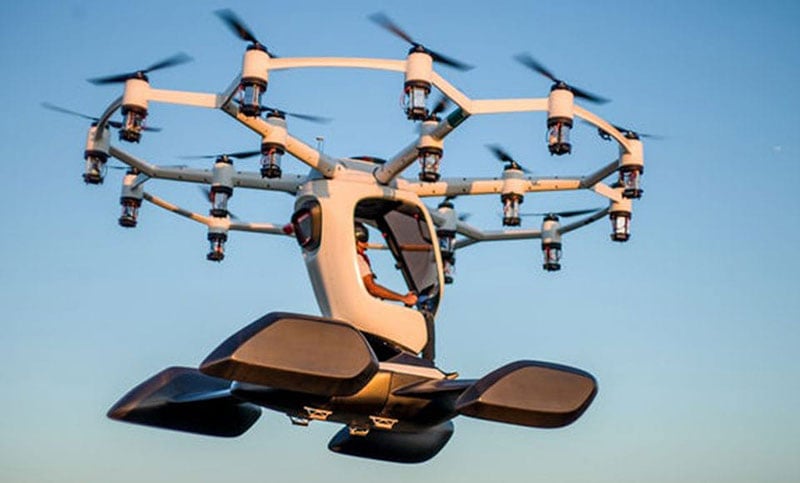
Hexa in flight (Photo: Lift)
Lift unveiled its eighteen rotor “Hexa” unmanned/manned aircraft over a year ago – what’s new now is that over 13,000 people have signed up to take one for a ride. The large drone weighs in at 432 lb and can fly for 10-15 minutes with a single passenger.
The Hexa has a single joystick with which the UAV is flown, and an on-board iPad provides route guidance and manages take-off and landing. Classed as a ‘Powered Ultralight’ air-vehicle, it can be flown without a pilot’s license – so Lift announced that it will offer Hexa flights to anyone wanting to fly (in 25 selected US cities) provided they physically fit into it and weigh less than 250lb. Lift apparently intends to map each recreational flight area in 3D, and plug this map into the vehicle control system. Currently the13,000 people who are signed up can expect to pay around $125-250 for each joy ride. Lift has yet to announce the first location where the fun rides will take place.
Counter UAC System downs drones in Philippines
The Southeast Asian Games were recently held in the Philippines with thousands of participants from eleven countries of Southeast Asia — the event was spread across 23 cities around the country. However, a number of uninvited drones showed up during the opening ceremonies on November 30th to take a look, but fortunately all were quickly dispatched.
The DroneShield counter-UAS system had been deployed in advance for protection of the event, and the local security forces used the system to detect and disable the invaders. According to the company, security personnel found the drones using body worn RF detection devices, and the Dronegun was then used to disable them.
Jamming the control link and GNSS L1 and L2 frequencies, UAVs are generally stopped in mid-flight when illuminated by the rifle-like device. DroneNode jammer in a suitcase was also used to provide blanket protection over a 1km circular area when the alarm was raised.
In all, seven unauthorized drones were disabled, some of which were apparently flying near the intended flight path of the helicopter bringing President Rodrigo Duterte to the opening ceremony.
Summary
It might seem a little ridiculous that we’ve had to come up with systems to counter uninvited or malicious drones (C-UAS). Making provisions for protection is probably something most sensitive facilities will have to do. Its possible that governments may already be investing in such technology to protect many facilities. More drones available for useful, productive and even recreational applications means some can end up in the wrong hands.
Nevertheless, good stuff comes out of drone applications, and the benefits seem to by far outweigh the need to protect ourselves against bad actors.