Publicerad den Lämna en kommentar

Septentrio strengthens inertial GNSS portfolio with AsteRx-i D UAS

A new high-performance compact GPS/GNSS receiver with an on-board IMU sensor, tailored to the needs of UAV applications

Septentrio, a world leader in high-precision GNSS positioning solutions, has announced a new GNSS/INS receiver, AsteRx-i D UAS. This multi-frequency receiver combines reliable centimeter-level positioning with 3D orientation, enabling automated navigation of aerial drones and robots.

GNSS signals received include the American GPS, European Galileo, Russian GLONASS, Chinese BeiDou, Japan’s QZSS and India’s NavIC.

With a high-performance IMU (inertial measurement unit) from Analog Devices integrated directly into the receiver board, AsteRx-i D UAS is compact and lightweight. Aboard the drone, its small form-factor combined with exceptionally low power consumption results in extended battery life and longer flight times.

“With this product we introduce into our inertial-GNSS portfolio an IMU which allows us to reduce the weight and power consumption of our UAS boards while making them easier to integrate. These are all key elements for a successful UAV platform.”

AsteRx-i D UAS is the first commercial product resulting from Septentrio’s collaboration with Analog Devices, delivering robust positioning and attitude (heading, pitch and roll) in demanding industrial environments. Both single-antenna and dual-antenna versions are available.

The single-antenna version provides a lightweight solution optimizing the system SWaP (size, weight and power). The dual-antenna version is designed for machines that need reliable heading directly from the start.

AsteRx-i D UAS comes with Septentrio’s Advanced Interference Mitigation (AIM+) technology. In aerial drones, where many electronics are crammed into a small space, neighboring devices can emit electromagnetic radiation, interfering with GNSS signals. AIM+ offers protection against such interference resulting in faster set-up times and robust continuous operation.

The on-board IMU from Analog Devices is exceptionally robust against mechanical vibrations. This IMU combined with Septentrio’s anti-shock LOCK+ technology makes AsteRx-i D UAS resilient against impact during takeoff and landing.

The AsteRx-i D UAS evaluation kit is now available in Septentrio’s online shop, which offers direct access to the company’s latest GNSS technology. For more information, contact sales@septentrio.com.

Related insight articles: Revolutionizing Precision Ag: drones with high-performance GPS+INS


Feature image: Septentrio

Publicerad den Lämna en kommentar

Geodata.se – Nyhetsbrev nr 3 – 2020

Översyn av kompetensläget inom geodataområdet

Under hösten 2019 påbörjades en utredning avseende kompetensläget inom geodataområdet. Uppdraget som utförs inom ramen för Geodatarådes nationella godatastrategi för åren 2016-2020 syftar till att:

  • Få fram en aktuell beskrivning över situationen med befintliga professurer, doktorander och utbildningsplatser inom geodataområdet, här avgränsat av områdena geodesi, fotogrammetri/laserscanning, GIS, geografisk informationsteknik, fjärranalys, tekniskt lantmäteri.
  • Ta fram en jämförelse med våra skandinaviska grannländer samt Nederländerna och Österrike.
  • Göra en undersökning som innefattar behovet av professurer, doktorander och ny-utexaminerade inom arbetsområdet inom en tidshorisont om fem år.
  • Dra nytta av erfarenheter från tidigare utförda undersökningar.
  • Ställa frågan: är dagens utbildningar relevanta eller behövs det nya med tanke på efterfrågan på kompetens?

Dom som ingår i arbetsgruppen är Linda Sabel Lantmäteriet (sammankallande), Lars Harrie Lunds Universitet, Håkan Olsson Sveriges LantbruksUniversitet, Steffen Holger Lantmäteriet, Jesper Paasch Lantmäteriet/Högskolan i Gävle, Milan Horemuz Kungliga Tekniska Högskolan, Maria Nässert Ericsson Lantmäteriet, Magnus Forsberg Lantmäteriet (beställare geodatarådet).

Gruppen har arbetat intensivt för att få fram utgångsmaterial för att kunna dra slutsatser till rapporten. Bl.a har enkätundersökningar genomförts hos Geodatarådets medlemmar, företag inom branschen, lärosäten och kommuner. Dialog har förts med representanter från olika länder, det har gjorts en inventering av forskningsmedel som går till geodataområdet. En analys av utbildningsutbudet har genomförts vid olika lärosäten, inklusive hur stort elevintaget är och hur många som avslutar sin utbildning. Även tidigare utredningar och aktiviteter som har genomförts i Geodatarådets regi har studerats. Gruppen som jobbar med utredningen siktar på att få rapporten klar till juni månad 2020.

Webbplatsen www.geodata.se avvecklas

Enligt tillgänglighetsdirektivet så ser vi att webbplatsen www.geodata.se inte uppfyller de uppställda kraven. Senast den 23/9 måste alla webbplatser, e-tjänster och digitalt publicerade dokument ha anpassats till de nya kraven. Att uppfylla tillgänglighetskraven innebär ett omfattande jobb med anpassning för  www.geodata.se och med det material som finns publicerade där. Med bakgrund av det så kommer www.geodata.se att upphöra som självständig domänadress och flyttar in på domänen www.lantmateriet.se (öppnas i nytt fönster) med all medföljande funktionalitet tex geodataportalen.

I och med att www.geodata.se upphör så upphör även detta nyhetsbrev. Vi återkommer framledes med mer information om den framtida utformningen.

Nyhet från geodata.se, orginal inlägg

Publicerad den Lämna en kommentar

Microchip offers phase noise analyzer for precision oscillator characterization

Next-generation phase noise instrument combines timing technologies in a smaller, higher performance measurement instrument

Photo: Microchip Technology

Photo: Microchip Technology

To help research and manufacturing engineers make precise and accurate measurement of frequency signals, including those generated by atomic clocks and other high-performance frequency reference modules and subsystems, Microchip Technology Inc. has announced the availability of the new 53100A Phase Noise Analyzer, a next-generation phase noise test instrument.

The 53100A Phase Noise Analyzer is designed for engineers and scientists who rely on precise and accurate measurement of frequency signals generated for 5G networks, data centers, commercial and military aircraft systems, space vehicles, communication satellites and metrology applications.

Capable of measuring radio frequency (RF) signals up to 200 MHz, the new test instrument rapidly acquires frequency signals and characterizes the phase noise, jitter, Allan deviation (ADEV) and time deviation (TDEV) quickly and precisely. All attributes of a frequency reference can be completely characterized with a single instrument within minutes.

The 53100A Phase Noise Analyzer enables a variety of configurations by allowing up to three separate devices to be tested simultaneously using a single reference, enabling higher capacity for stability measurements. At 344 x 215 x 91mm (13.5 x 8.5 x 3.6 inches), the phase noise test instrument is small enough for integration into manufacturing automated test equipment (ATE) systems, yet powerful enough for laboratory-grade metrology. Its interface provides backward compatibility with Microchip’s 51xxA test sets’ command and data stream, reducing the need to redesign existing ATE infrastructure.

The 53100A Phase Noise Analyzer provides flexibility by allowing an input reference device to be connected through the front panel at a different nominal frequency than the device under test — allowing a single reference to characterize a variety of oscillator products. Rubidium frequency standards such as Microchip’s 8040C-LN or a quartz oscillator such as Microchip’s 1000C Ovenized Crystal Oscillator (OCXO) could be used as a reference as well as other manufacturers’ precise oscillators.

The 53100A Phase Noise Analyzer is available now. Microchip supports the 53100A Phase Noise Analyzer with technical support services as well as an extended warranty.

Publicerad den Lämna en kommentar

Garmin offers insights on active lifestyles during COVID-19

Photo: playb/E+/Getty Images

Photo: playb/E+/Getty Images

Garmin has released data that highlights activity trends throughout the COVID-19 pandemic.

According to the company, the week President Donald Trump declared a national state of emergency marked a major shift in human activity.

Garmin data pointed to a massive decline in the overall number of steps taken during the second two weeks of March in the U.S. This trend is consistent with the company’s global trend data in China, Italy and other countries where the coronavirus pandemic struck first.

“We’re observing a remarkable shift in the types of activities people are doing, reflecting an unprecedented about-face when it comes to typical springtime exercise and activity,” Garmin said in a blog post.

To paint a clear picture of the initial trends, Garmin engineers and data analysts looked at the percent change in activity levels in the United States for specific sports and exercises and compared the first half of March with the second half of March to determine increases and decreases. The results also are baselined against the same time period in 2019.

Here’s an overview of how activity has changed.

  • Skiing and snowboarding: These activities are down 96%. This aligns with resorts closing because of the pandemic.
  • Cycling: Virtual cycling activity was up 64% in the second half of the month, a shift that appears even more atypical when comparing it to the same time period last year. March 2019 saw a 20% decline in the activity as cyclists naturally began to take their rides outside to enjoy the warmer weather, Garmin said.
  • Indoor/treadmill running: Indoor/treadmill running is down 44%. According to Garmin, this doesn’t mean this activity has come to a halt. Because gyms across the country are closed, a number of treadmills aren’t being used. In fact, virtual running saw a steep increase in the second half of March, and despite gym closures, overall indoor cardio is holding strong over 2019 levels and showing an 18% week-over-week increase from March 16 to March 30. This suggests more people are exercising, and they’re finding ways to do it from home, with and without their own equipment, Garmin said.
  • Lap swimming: Lap swimming is down 88%.
  • Walking: Walking is up 36% when comparing the front half of March to the back half of March. This surge is double the 18% increase observed over the same time period last year, Garmin reported.
  • Yoga: Garmin wearable device data shows an 11% increase in yoga activity, when comparing the front and back halves of the month. This is an increase in 2019 data, as well.
  • Golf: Golf has seen a 20% decline in activity for the second half of March. When comparing the same two time periods last year, golfing activity increased by 53%.
Publicerad den Lämna en kommentar

Trimble Dimensions 2020 canceled because of COVID-19

Logo: Trimble Dimensions 2020

The 2020 Trimble Dimensions conference has been canceled because of COVID-19.

According to the company, Trimble Dimensions is the signature event for Trimble’s global user community spanning agriculture, construction, geospatial, transportation, utilities and more. The show highlights technology and how it transforms the way professionals work to achieve success.

“Unfortunately, the overwhelming concerns and ongoing impact of COVID-19 inhibit our ability to deliver a conference that meets the high standards of safety and excellence our attendees expect and deserve,” Trimble said in a press release.

The event was scheduled to take place Nov. 2-4 at the Gaylord Opryland Resort and Convention Center in Nashville, Tennessee. Trimble Dimensions is a biennial event.

Publicerad den Lämna en kommentar

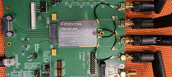
Fibocom module completes first data call on China’s 5G standalone network

Fibocom’s 5G modules FG150 and FM150 have completed the first data call and end-to-end data transmission services under China Mobile’s Standalone-Structured 5G network. The download rate exceeds 100 Mbps.

Fibocom is a leading provider of cellular embedded wireless module solutions for the internet of things (IoT).

Fibocom FG150 and FM150 5G modules are the first 5G modules based on the Qualcomm SDX55 platform to offer the data-transmission services under the SA-structured 5G network in China, Fibocom said. Its IoT wireless modules incorporate GNSS receivers that receive GPS, GLONASS, Galileo and Beidou signals.

See a test video here:

“Wireless modules are essential for communication between IoT terminals and the base stations. As the world’s leading IoT wireless module solution provider, we are proud that our 5G modules have achieved another R&D milestone in the industry,” said Tiger Ying, CEO of Fibocom. “The completion of the first data call under SA-Structured 5G network is a significant step towards realization of all the three 5G features (eMBB, uRLLC, mMTC) in IoT industry and helps our customers to accelerate the large-scale deployment of 5G industry applications.”

The test was run on the Fibocom FM150 5G module with China Mobile’s 5G SIM card under the n41 network frequency band in the Shenzhen Mobile 5G Joint Innovation Center.

The Fibocom FM150 5G module has been successfully registered on the 5G SA network and established the PDU session. In the 5G SA communication process, the establishment of the PDU session is a symbolic link for successful dialing.

Photo: Fibocom

Photo: Fibocom

Fibocom FG150 and FM150 5G modules support both 5G SA and NSA network architectures, providing an integrated multi-network solution that is compatible with the global 5G Sub 6 and millimeter-wave bands. Fibocom 5G modules are compatible with both LTE and WCDMA standards, reducing customers’ investment in the early stages of 5G deployment and helping customers to switch their older product lines to 5G product lines quickly.

Fibocom’s 5G modules have global coverage, accelerating scale deployment of the 5G IoT applications. Applications include: 4K/8K video live broadcast, cloud office (ACPC), drone, robot, AR/VR, 5G virtual dress mirror, 5G cloud game, 5G digital signature, 5G wireless gateway, 5G CPE, 5G SD-WAN, smart grid, telemedicine, connected cars, intelligent transportation system, autonomous driving, smart homes and smart cities.

Publicerad den Lämna en kommentar

UAVOS parachute system for UAS proved effective

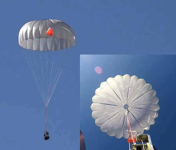
UAVOS has successfully tested its new two-stage parachute system. The new parachute system provides slow descent of a UAS at high speed. It includes two parachutes — the pilot chute and a main chute used to slow and stabilize the UAS.

The decrease in the load speed on the UAS occurs due to the main chute opening delay function, when the pilot chute opens first. The parachute system is designed for UAS with speeds of up to 280 mph (450 kph) and weight of up to 110 lb (50 kg).

Watch the parachute in action:

The pilot chute allows safe, slow descent of the UAV during the main parachute deployment, as well as to open up the main chute at a minimum altitude.

After landing, the group of the main parachute lines is automatically unfastened to collapse the canopy of the main chute and releases after touchdown to avoid dragging the aircraft along the ground. Unfastening is carried out by the lock of a three-step release:

Stage 1: Opening the pilot chute
Stage 2: Opening the main chute
Stage 3: Release of the group of lines of the main parachute

“In the aircraft safety developments, saving an entire aircraft through a deployable parachute system is a crucial thing,” said Aliaksei Stratsilatau, CEO and lead developer of UAVOS. These trials have generated an amount of data that allows us to quantify the performance of parachute system for future missions. Computer modeling cannot capture all the complexities. Parachutes encounter turbulent and dynamic airflow, which is almost impossible to replicate with computers. The only way to get a handle on all the possibilities is test.”

Photo: UAVOS

Photo: UAVOS

Publicerad den Lämna en kommentar

GPS, inertial technology support defense missions

2 SOPS never stops

There’s no question that GPS is an essential service. The Second Space Operations Squadron (2 SOPS) is continuing to provide a global utility during the COVID-19 pandemic.

“No matter what, we need to ensure this mission continues so the American people and the world know they can depend on us to be the gold standard in precision navigation and timing,” said Lt. Col Stephen Toth, 2 SOPS commander. Services that use GPS include ambulances, hospitals, police departments and fire departments.

“It would make a global pandemic that much worse if we were to go down,” Toth said. “It could prevent a lot of the day-to-day things we rely on from happening, it could be catastrophic.”

GPS supports 14 of 16 essential industries in the United States. “We’ll remain reliable no matter what the condition the world is in,” Toth said. “Whether it be a pandemic, hurricane, tornado or any other type of crisis, we have plans and training for whatever threat we may face so the mission doesn’t stop.”

Unlike other jobs across the Department of Defense, those directly conducting operations can’t telework. They need to be in a sensitive compartmented information facility or restricted area in a secured area to access specific terminals and networks.

“The American people can count on space and they can count on our military to continue to provide the level of capability that’s expected no matter what’s going on in the world,” Toth said. “In times of crisis, people shouldn’t have to question whether we’ll be here or not, because we will and the mission won’t stop.”

Welcome to the Space Force

The official Space Force emblem was unveiled on Jan. 24. (Logo: United States Space Force)

The official Space Force emblem was unveiled on Jan. 24.

Organized as a military service branch within the U.S. Department of the Air Force, the newly created Space Force has taken the reins of the GPS program.

Established on Dec. 20, 2019, under the Fiscal Year 2020 National Defense Authorization Act, the Space Force will be set up over the following 18 months. Commander of U.S. Space Command, Gen. John “Jay” Raymond, was sworn in Jan. 14 as the first chief of space operations of the U.S. Space Force, and is stationed at the Pentagon.

The same staff who have operated satellites and conducted space activities in the Air Force are continuing under the Space Force. Under the Space Force are the Space and Missile Systems Center at Los Angeles Air Force Base and the GPS Master Control Station, operated by the 50th Space Wing’s 2nd Space Operations Squadron (2 SOPS) at Schriever Air Force Base, Colorado. The 50th Space Wing is under Space Operations Command, located at Vandenberg Air Force Base, California.

25 years. The U.S. Space Force celebrated the 25th Anniversary of GPS reaching Full Operational Capability (FOC) on April 27, 2019. Over the past 25 years, GPS has become an integral technology that affects the lives of billions of people across the world.


Check out more case studies where GPS and inertial technology are supporting defense missions.

Publicerad den Lämna en kommentar

Developing systems to automate moving groups of trucks

In the United States, trucking companies and the Army are both developing systems to automate moving groups of trucks. While trucking companies are mostly interested in “platoons” of trucks drafting off of each other to save fuel, the Army wants its “convoyed” trucks to be hundreds of meters apart to improve their chances of surviving an enemy attack.

Battlefield challenges

While the biggest danger for platoons of commercial trucks is crashing, military convoys can be threatened by attacks with improvised explosive devices (IEDs) or rocket-propelled grenades.

Civilian truck drivers also benefit from a robust infrastructure, said Bernard Theisen, division chief for Ground Vehicle Robotics at the U.S. Army’s Ground Vehicles Systems Center (GVSC). For example, nearly all platooning trucks are limited to using roads and highways that have been mapped at centimeter-level resolution with lidar, can communicate over 3G or 4G networks, and have excellent GNSS signals. “I would love to have all that information,” Theisen said, “every time I send a robotic convoy vehicle out there.”

By contrast, the military must design a system that assumes “no comms, no prior data, and no infrastructure,” Theisen explained. “Sometimes a bridge that used to be there has been blown up or we may have put a new bridge across the water overnight. A building that was there yesterday got blown up and is now blocking the road. You cannot pre-plan that in the map and expect it not to change.”

Nevertheless, the civilian and military efforts share some challenges, Theisen acknowledged, including “perceiving the world, understanding it, processing the data, and making the right decisions.” Unlike robots, humans are very good at coping with the unexpected. “You can only train a robot so much, there will always be situations that it does not know how to handle.”

In a military convoy, every fourth or fifth truck may have a mounted gun to protect the convoy. The convoy will typically include one or more ambulances, wreckers and fuel tankers. “It is a different application than for Amazon or FedEx to send a couple of trucks down the highway,” Theisen said.

Leader-follower

In leader-follower applications, GVSC installs the same hardware on all its trucks. “This facilitates software maintenance, because you don’t need to have different versions,” Theisen said. If the convoy’s leader is disabled from a mechanical or battlefield issue, it is easy for a soldier on the next truck to authorize his truck to take over as the convoy’s new leader. “We have also created cases where the leader takes that road months ahead of the followers,” said Alberto Lacaze, co-founder and president of Robotic Research. “So, the leader does not need to be a part of the convoy.”

Rough terrain doesn’t affect navigation, except that in hilly terrain trucks might have more side-to-side drift than in a flat area. “We often use a three-axis IMU [inertial measurement unit] instead of a two-axis IMU, which might be all you need for a commercial application on flat roads,” Theisen said.

“The commercial problem is almost like carrying a group of trailers that are not mechanically connected,” Lacaze said. It is crucial to be able to tie in the vehicles’ low-level controls so that they maintain a very short separation. If those vehicles were trying too hard to maintain those very close distances by frequently accelerating and decelerating, the fuel-savings advantages from drafting would go away. By contrast, for military applications the exact distance between the trucks doesn’t matter much, but their side-to-side error does. “You would like all vehicles to be driving within one tire width of the lead vehicle’s tracks,” Lacaze said. “That has many advantages — for example, if that road has been demined.”

While commercial and military software largely overlap, their sensor requirements are fundamentally different. “Most commercial vehicles are not checking to see whether there is a crater in the middle of the road,” Lacaze said. Military vehicles need to detect such damage to the infrastructure and respond quickly.

Still, the military is interested in “the gigantic amount of mapping of the available infrastructure” being done by private companies, Lacaze said, because most military convoys are not in war-torn areas, but delivering materiel to bases in areas with some infrastructure.

Robotic modes

GVSC purchases commercial off-the-shelf (COTS) systems and integrates them into its trucks, Theisen explained, producing five robotic modes:

  • Warning, which consists of “idiot lights” and buzzers alerting human drivers that, for example, they are straying out of a lane or are about to hit something
  • Driver assist mode, which helps drivers brake, accelerate and steer
  • Teleoperation, which consists of driving the truck from a remote location
  • Waypoint navigation, which uses a GNSS waypoint path that can either be pre-programmed or pre-driven and then replayed
  • Leader-follower, in which the first vehicle leads and potentially any number of vehicles follow.

Regarding the driver assist mode, Theisen pointed out that “all these features are very common in high-end cars and you are seeing them coming into many Class 8 trucks. We don’t do any development in the Army from that standpoint.” Regarding the leader-follower mode, the first truck can be driven in any of the other four modes.

GVSC is the lead system integrator for 30 robotic palletized loading systems (PLSs) that the Army has at Fort Polk, Louisiana, and another 30 at Fort Sill, Oklahoma. Nevertheless, a human driver usually leads the robotic convoy. The driver determines the best route, assesses the situation, and is normally followed by three unmanned systems. “That is why we call our system semi-autonomous,” Theisen said.

The role of GNSS

The Olli shuttle, equipped with Robotic Research’s AutoDrive kit, is deployed on busy boardwalks, campuses and public roads. (Photo: Robotic Research)

The Olli shuttle, equipped with Robotic Research’s AutoDrive kit, is deployed on busy boardwalks, campuses and public roads. (Photo: Robotic Research)

For both commercial platooning and military convoying, GNSS signals are used for redundancy but not as the primary source of measurement of the distance between the trucks. “None of the systems that we have deployed on the commercial side — for example, with Local Motors vehicles (the Olli shuttle) — rely on GNSS,” Lacaze said, though they will use those signals if available. The high accuracy of their inertial systems make it hard to spoof or jam GNSS receivers, because the system would detect any changes in the GNSS solution and the vehicles would continue running on inertial navigation if the GNSS signal were jammed.

“We assume that we will not have GNSS information because sometimes we are jamming ourselves or are being jammed or the enemy could be spoofing us,” Theisen said. Most of GVSC’s systems use “nav boxes” sold by multiple vendors that enable vehicles to navigate for long periods without GNSS signals. They typically combine one or two GNSS receivers, an IMU or several smaller ones, a combination of wheel encoders or ground sensors to determine ground speed, and a digital compass.

GVSC’s trucks also use lidar to generate voxel maps of their current surroundings, and then share them with the other trucks in the convoy. Each vehicle tracks the vehicle in front of it and can just follow it, if it has insufficient position information or good visual cues.

GVSC looks for the highest possible GNSS accuracy, whether using civilian GNSS receivers or military Selective Availability Anti-Spoofing Module (SAASM) units. “We also take advantage of the future M-code,” Theisen said. “We do have capabilities that the civilian marketplace does not have.”

Remaining obstacles

The remaining bottleneck in the development and implementation of convoys of autonomous military vehicles is the approval process, Lacaze said. “Currently, if we make changes to the autonomy systems, the testing parts of the government are asking us to drive hundreds of thousands of miles before providing approvals. It is still a challenge to figure out at what point these vehicles are safe enough to provide to the soldiers and what the cost of doing so is.”

For these systems to take off, better processors, sensors (cameras, radars and lidars) and algorithms are required, Theisen said. “There is way more sensor data that you can collect and process in real time.”


Featured photo, provided by Robotic Research: Army convoys can stretch for miles. The U.S. Army’s Autonomous Ground Resupply trucks shown here are connected with Robotic Research’s autonomous technology. 

Publicerad den Lämna en kommentar

Emcore provides defense-ready IMUs

The SDI500 Tactical Grade IMU (Photo: Emcore)

The SDI500 Tactical Grade IMU (Photo: Emcore)

Emcore is offering two inertial measurement units (IMUs) suitable for the defense market.

SDI500 Tactical Grade IMU. Emcore’s Systron Donner Inertial SDI500 is a high-performance MEMS-based IMU that demonstrates true tactical grade performance with 1°/hour gyro bias and 1-mg accelerometer bias stability with very low 0.02°/hr angle random walk. Its performance is based on Emcore’s quartz MEMS inertial sensor technology. The SDI500 is designed to achieve the demanding performance levels required in sophisticated systems applications. Packaged in a highly miniaturized, cylindrical configuration with a volume of 19 cubic inches, it is suitable for use by integrators and OEMs.

The SDI500 is a compact IMU constructed with SDI’s next generation quartz gyros, quartz accelerometers, and high-speed signal processing that achieves tactical grade performance. The SDI500 IMU is rated for rugged military environments.

EN-300 Precision Fiber Optic IMU/INS (Photo: Emcore)

EN-300 Precision Fiber Optic IMU/INS (Photo: Emcore)

EN-300 Precision Fiber Optic IMU/INS. The EN-300 inertial system is designed to be compatible in form, fit and function with a legacy equivalent, but with the higher accuracy and performance needed for GPS-denied navigation, precise targeting and line-of-sight stabilization.

It features navigational-grade performance with 0.04°/hr gyro bias and 0.1-mg accelerometer bias stability with ultra-low 0.007°/hr angle random walk.

Internal signal processing provides full stand-alone or aided navigation, and as an option can provide standard IMU delta velocity and delta theta.