Publicerad den Lämna en kommentar

Mapping air quality from Canada’s wildfire smoke

Smoke from the Canadian wildfires continues to pollute the air across the United States, mainly affecting cities in the northeast, including Pittsburgh, Chicago, Cleveland, Detroit and Buffalo.

According to the New York Times, in early June, the level of particulate matter in the air from smoke became so unhealthy that many U.S. cities set records. Visibility decreased in many cities as well, with the smoke creating an orange haze.

Most of the smoke can be attributed to several fires burning across Canada. Many of these fires were caused by lightning; however, with above-average temperatures and dry conditions, wildfires have been breaking out since May.

Photo:

A storm system off the coast of Nova Scotia forced smoke from the fires southeast into the United States. (Image: NOAA)

Based on data from the Canadian Interagency Forest Fire Centre, there are 480 active fires in Canada: 252 are out of control, 77 are being held in place, and 151 are under control.

The fires are mapped in the image below.

Photo:

The red dots represent the out-of-control fires, the green dots are fires being held in place, and the yellow dots are fires that are under control. (Image: Screenshot of CIFFC wildfire map)

Understanding air quality importance

The Air Quality Index (AQI) measures the density of five pollutants: ground-level ozone, particulates, carbon monoxide, nitrogen dioxide, and sulfur dioxide. It was originally established by the Environmental Protection Agency to communicate the cleanliness of the air Americans are breathing every day.

The index runs from zero to 500 — the higher the number the more polluted the air is.

Effects of air pollution can range from mild symptoms, such as eye and throat irritation, to serious ones such as heart and respiratory issues. Pollution can cause inflammation of the lung tissue and increase the vulnerability to infections.

During wildfires, fine particles in the soot, ash and dust can fill the air.

The AQI identifies the concentration of particles smaller in diameter than 2.5 μM. When these particles are inhaled, the tiny specks can increase the risk of heart attacks, cancer, and respiratory infections — especially in children and older adults.

Below is an updated map of air quality from the U.S. AQI as of June 28.

Photo:

The colors on the map range from yellow — which is unhealthy air quality — to purple, meaning the air quality is hazardous. (Image: AirNow.gov)

Publicerad den Lämna en kommentar

uAvionix receives FCC/FAA approval for C-band BVLOS operations

Image: uAvionix

Image: uAvionix

uAvionix has received Federal Communications Commission (FCC) approval, coordinated with the Federal Aviation Administration (FAA), to operate its SkyLink C-band command and control (C2) radios for beyond visual line of sight (BVLOS) operations at the Choctaw Nation of Oklahoma Emerging Technology test site.

The radios — operating on aviation-protected C-band frequencies — will be controlled by uAvionix’s SkyLine cloud-based C2 network solution that supports fleet management, network health monitoring, detect and avoid, and roaming between multiple radio networks and ground stations.

According to uAvionix, with the BVLOS Waiver, businesses looking to use aviation-protected C-band and other radio networks for assured control and non-payload communications can now develop, test and implement solutions for business initiatives such as package delivery and medical resupply.

With over 200,000 tribal members and more than 11,000 employees, the Choctaw Nation is the third largest Indian nation in the United States. It is developing an aviation test facility in southeastern Oklahoma that utilizes more than 44,600 acres of remote land it tribally owns to support the innovative research, development, test and evaluation of emerging manned and unmanned aerial system technologies in a safe and low-risk environment.

Interested businesses should contact the Choctaw Nation and uAvionix to support implementation and scaling of uncrewed aerial system operations with multiple C2 links including aviation protected C-band.

Publicerad den Lämna en kommentar

GMV secures contract with ESA for G2G ground segment

Contract ceremony in Madrid, Spain, on June 22. (Image: GMV)

Contract ceremony in Madrid, Spain, on June 22. (Image: GMV)

GMV has been awarded a major contract by the European Space Agency (ESA) to develop the ground control segment for the in-orbit validation (IOV) system of the Galileo Second Generation (G2G). The primary objectives of G2G are to introduce new services and technologies; improve existing services and technology; increase the accuracy and robustness of the system; strengthen security; and reduce the system’s maintenance costs.

The ground segment will be responsible for controlling the two new second-generation satellite platforms, which are currently in the design and production phase. A total of 12 satellites are expected to be launched over the next three years. The new ground control system is scheduled to come into operation in 2

025, coinciding with the launch of the first satellite of this second generation.

The new contract signed between GMV and ESA is worth over €200 million. This includes the contracting of core G2G activities, for a value of around €155 million. These activities will be carried out over a period of 42 months, from mid-2023 until the end of 2026, with options for extension until 2028.

Galileo currently serves more than four billion users worldwide, delivering global positioning, navigation, and clock synchronization services with a positioning accuracy of up to 20 cm.

Publicerad den Lämna en kommentar

GPS World takes flight: XPONENTIAL 2023

Photo:

Photo: Maddie Saines

On May 8-11, GPS World staff attended the AUVSI XPONENTIAL show at the Colorado Convention Center in downtown Denver. There were more than 600 booths in the exhibit hall, and the staff was able to visit several of the exhibitors, including Tualcom, SBG Systems, Inertial Labs and Honeywell. They also attended educational sessions lead by industry leaders and participated in insightful discussions about the future of UAVs and overall autonomy. For highlights from XPONENTIAL, click here.

Publicerad den Lämna en kommentar

ComNav releases T20 palm RTK

Image: ComNav Technology

Image: ComNav Technology

ComNav Technology has released the T20 palm real-time kinematic (RTK). The GNSS receiver with advanced technology is designed for surveying and mapping, GIS, marine, precision agriculture and machine control.

T20 is light, weighing in at 0.68 kg, and has low power consumption with 12 hours of battery life. It integrates functions such as a GNSS module, datalink module, 4G, 5.0 dual-mode Bluetooth, data memory system and more.

Powered by the SinoGNSS K8 high precision module, the T20 has 1,590 channels and can track all running and planned constellations including GPS, BDS, GLONASS, Galileo, QZSS and satellite-based augmentation systems. Additionally, the anti-interference algorithm enables the T20 to maintain accurate positioning and perform well in complex environments, providing surveyors with high-quality measurements.

The T20 is equipped with a third-generation inertial measurement unit from ComNav, which can be tilted and measured at an angle up to 60°. The T20 is also equipped with a U50 datalink module, which enables it to switch between base and rover.

The T20 is compatible with mainstream RTK receivers on the market.

Publicerad den Lämna en kommentar

NavIC ninth navigation satellite launched

The Indian geosynchronous satellite launch vehicle (GSLV) launched on May 29, carrying the first of the Navigation with Indian Constellation (NavIC) second-generation navigation satellites. This brings the NavIC satellite total to nine.

The GSLV, dubbed NVS-01, has a mission life of 12 years and features an indigenous rubidium atomic clock developed by the Indian Space Research Organisation’s Space Applications Centre.

The NVS series satellites will sustain and augment the NavIC with enhanced features, including payloads that operate on L1, L5, and S-bands.

There are eight first-generation NavIC satellites on orbit: IRNSS-1A, IRNSS-1B, IRNSS-1C, IRNSS-1D, IRNSS-1E, IRNSS-1F, IRNSS-1G and IRNSS-1I. NVS-01 will become the ninth if the mission is successful.

Publicerad den Lämna en kommentar

QGIS Grant Programme 2023 Results

We are extremely pleased to announce the 4 winning proposals for our 2023 QGIS.ORG grant programme:

Funding for the programme was sourced by you, our project donors and sponsorsNote: For more context surrounding our grant programme, please see: QGIS Grants #8: Call for Grant Proposals 2023.

The QGIS.ORG Grant Programme aims to support work from our community that would typically not be funded by client/contractor agreements. This means that we did not accept proposals for the development of new features. Instead proposals focus on infrastructure improvements and polishing of existing features.

Voting to select the successful projects was carried out by our QGIS Voting Members. Each voting member was allowed to select up to 6 proposals. The full list of votes are available here (on the first sheet). The following sheets contain the calculations used to determine the winner (for full transparency). The table below summarizes the voting tallies for the proposals:

A couple of extra notes about the voting process:

  • Voting was carried out based on the technical merits of the proposals and the competency of the applicants to execute on these proposals.
  • No restrictions were in place in terms of how many proposals could be submitted per person / organization, or how many proposals could be awarded to each proposing person / organization.
  • Voting was ‘blind’ (voters could not see the existing votes that had been placed).

We received 35 votes from 20 community representatives and 15 user group representatives.

On behalf of the QGIS.ORG project, I would like to thank everyone who submitted proposals for this call!

Nyhet från QGIS, orginal inlägg

Publicerad den Lämna en kommentar

U-blox releases two GNSS positioning modules

NEO-F9P.png

Image: u-blox

U-blox has released two modules based on the u-blox F9 high-precision GNSS platform. The low-power NEO-F9P supports precise navigation and automation of moving industrial machinery, and the ZED-F9P-15B provides customers in the mobile robotics market with an L1/L5 option in addition to the L1/L2 bands.

The NEO-F9P and the ZED-F9P-15B GNSS modules feature concurrent reception of GPS, Galileo, and BeiDou; multi-band L1/L5 real-time kinematic; short convergence times; and reliable performance. The modules deliver centimeter-level accuracy in seconds and comes in small, high-precision module form factors.

ZED-F9P.png 

Image: u-blox

This small size, coupled with very low power consumption and ANN-MB1 antenna compatibility, makes the NEO-F9P suitable for a wide range of uses. Offering reliable and efficient positioning, the module supports open as well as standards-based correction services for enhanced performance, such as the u-blox PointPerfect GNSS augmentation service.

Publicerad den Lämna en kommentar

Launchpad: New antennas, scanners and survey applications

A roundup of recent products in the GNSS and inertial positioning industry from the May 2023 issue of GPS World magazine.


SURVEYING
OxTS Georeferencer 2.5

Survey Software
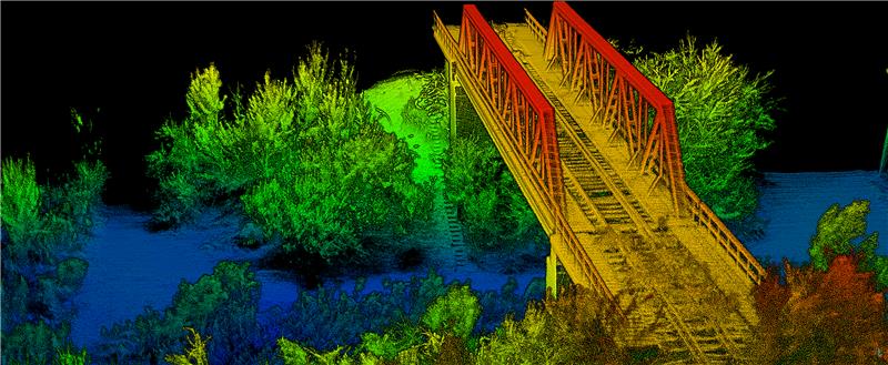
Georeference raw lidar data

Georeferencer 2.5 featuring anyNAV software is suitable for survey applications. Users of Georeferencer 2.5 with the anyNAV feature enabled can boresight payloads and georeference lidar data using the user’s navigation data. The anyNAV software enables lidar surveyors to create accurate point clouds quickly. Georeferencer 2.5 now takes navigation data from third-party inertial navigation systems, which enables users to use that data to georeference raw lidar data from multiple sensor families. The resulting data can then be viewed in many point cloud viewer software packages.
OxTS, oxts.com

Photo:

Inertial Navigation Solution
Designed to deliver accuracy in challenging environments

Ekinox Micro combines a high-performance MEMS tactical inertial sensor with a quad-constellation, dual-antenna GNSS receiver, making it suitable for mission-critical applications. The device includes pre-configured motion profiles for land, air and marine applications, enabling the sensor and algorithms to be tuned for maximum performance in any condition. The device is designed for ease of use and integration, with simple connectors, a web configuration interface, datalogger, Ethernet connectivity, a PTP server, a REST API for configuration, and multiple input and output formats. Ekinox Micro is compatible with real-time kinematic (RTK) solutions and based on a tactical 0.8°/h class inertial measurement unit calibrated across the entire operating temperature range. It features accuracy roll/pitch of 0.015°, accuracy heading of 0.035°, and accuracy position of 1.2 m without any corrections or 1 cm in RTK. The device also meets the MIL-STD-461, MIL-STD-1275, and MIL-STD-810 standards.
SBG Systems, sbg-systems.com

Image: Hexagon

Lidar Sensor
High-performance airborne bathymetric solution for deep water surveying

The HawkEye-5 increases survey efficiency by up to 25% compared to previous generations. The technology expands the capabilities of the Chiroptera-5 bathymetric lidar system, enhancing the productivity of applications such as nautical charting, environmental monitoring, and maritime surveillance in deep waters. The technology is designed to fit the Leica PAV100 gyro-stabilized mount, which isolates the sensor from unwanted aircraft movements — resulting in consistent data density and more efficient area coverage. The HawkEye-5 combined with the Chiroptera-5 features three lidar sensors, one four-band camera, and a QC camera to collect data from the seabed to land.
Leica Geosystems, leica-geosystems.com

Image: SingularXYZ

GNSS Receiver
Complete with network RTK rover

The Sfaira One GNSS receiver is small and centimeter accurate. It provides users with an entry-level network real time kinematic (RTK) rover. Sfaira One is equipped with a GNSS module with 1,408 channels for GPS, BDS, GLONASS, Galileo and QZSS tracking — providing centimeter positioning in harsh environments. It also features advanced RTK and an anti-interference algorithm. The GNSS receiver connects via Bluetooth and can be configured to conduct surveying tasks on a smartphone. Additionally, Sfaira One supports SingularPad and SingularSurv software and is also compatible with mainstream field survey or GIS software. Sfaira One is IP65 dustproof and waterproof, which makes the receiver suitable for all weather conditions. It has a 4,800 mAh battery life with 16 hours working time and type-C interface that can be charged on-the-go with a power bank.
SingularXYZ, singularxyz.com


MAPPING

Photo:

Mobile Mapping Solution
Built for large-scale infrastructure measurement and digital twin creation

The Pegasus TRK100 is small and light, making it easy to mount on any vehicle. The mobile mapping system features the same modular hardware approach that enables users to add more cameras to expand the range of use cases. With its advanced mapping capabilities, the Pegasus TRK100 enables GIS professionals to visualize and understand the location of assets to help make the right decisions, improve asset management, and support infrastructure building and maintenance. The Pegasus TRK100 combines artificial intelligence and a learning algorithm to enhance and optimize the clarity of points in post-processing for improved accuracy. The versatility of the Pegasus TRK100 suits a variety of applications in diverse industries, including telecommunications, utilities and road maintenance.
Leica Geosystems, leica-geosystems.com


OEM

Photo:

Photo:

Helix Antenna Series
Suitable for unmanned system applications

HX-CUX012A is designed with an extremely low profile, making it suitable for integration into UAVs, surveying and monitoring devices. It reduces the overall weight of applications, enables multipath mitigation and more. HX-CUX005A is a solution for integrated helix antenna applications. It is designed with the integration of a GNSS antenna and Bluetooth/Wi-Fi antenna, enabling communication and navigation without mutual interference. HX-CH7609A is a low profile and small size housed helix antenna. It has comprehensive GNSS support including GPS, GLONASS, Galileo, BeiDou, as well as L-band correction services. HX-CH7609A features centimeter phase center repeatability and high gain at a low elevation. With signal filtering and multipath rejection, it provides reliable and stable GNSS signals. HX-CHX600A is a high-performance helix antenna that receives GPS, Galileo, BeiDou, GLONASS, as well as L-band signals. With 4.2 dBi high gain, it provides suitable tracking performance at a low elevation angle. Its low noise figure design reduces transmission interference and improves signal quality.
Harxon, en.harxon.com

Credit: Tallysman Wireless

Helical Antenna
Suitable for UAV applications

The HC990XF helical antenna is designed for precise positioning, covering the GPS/QZSS L1/L2/L5, QZSS L6, GLONASS G1/G2/G3, Galileo E1/E5a/E5b/E6, BeiDou B1/B2a/B2b/B3, and NavIC L5 frequency bands. This includes the satellite-based augmentation system (SBAS) available in the region of operation as well as L-band correction services. The HC990XF has a base diameter of 64 mm, is 37 mm tall and weighs 45 g. Its precision-tuned helical element provides full GNSS band coverage, suitable gain and axial ratio, and a tight phase center. The antenna base has an SMA (male) connector, three screw holes for secure attachment and an O-ring to waterproof the antenna connector. The HC990XF helical design does not require a ground plane, making it a suitable antenna for UAV applications.
Tallysman Wireless, tallysman.com

STMicroelectronics

Inertial Module
For automotive uses

The ASM330LHB automotive-qualified MEMS inertial-sensing module provides accurate measurements for a wide variety of vehicle functions. With the dedicated software provided, ASM330LHB also addresses functional-safety applications up to ASIL B1. ASM330LHB contains a 3-axis digital accelerometer and 3-axis digital gyroscope that provides a six-channel synchronized output. The module’s high-accuracy inertial measurements are used to improve the precise positioning of a vehicle. The accelerometer and gyroscope maintain high stability over time and temperature, and have very low noise for an overall bias instability of 3°/hour. Specified over the extended temperature range, -40°C to 105°C, the ASM330LHB has multiple operating modes that let designers optimize the data-update rate and power consumption.

ASM330LHB can support advanced driver assistance systems or vehicle-to-everything communication, as well as help stabilize sensing systems such as radar, lidar and visual cameras, and assist semi-automated driving applications up to L2+. Additionally, ASM330LHB can be used to enable a variety of functionalities in the body of a vehicle. ASM330LHB was developed with the automotive functional-safety standard ISO 26262 — the ASIL B compatible software library has been certified independently by TÜV SÜD. By implementing dedicated safety mechanisms, including data integrity and accuracy, the library ensures compliance with ASIL B automotive systems.

With the companion software engine, the ASM330LHB supports the growing adoption of automotive systems that require safety integrity up to level B. The combination of two ASM330LHB sensor modules for fail-safe redundancy delivers resilient contextual data for driver-assistance applications such as lane centering, emergency braking, cruise assistance and semi-automated driving. ASM330LHB is AEC-Q100 qualified and in production now in a 2.5 mm x 3.0 mm 14-lead VFLGA package.
STMicroelectronics, st.com
Credit: OxTS

INS
Built for automation applications

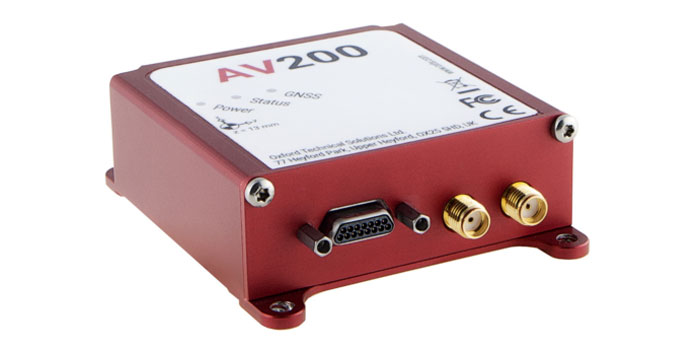
The AV200 is designed to give precise location data. It includes quad-constellation, dual-antenna, real-time kinematic (RTK) GNSS to provide users with position data as well as its temperature-calibrated, multi-core inertial measurement unit. These technologies give the AV200 position accuracy within 0.05 m, heading accuracy of 0.2°, and velocity accuracy of 0.2 km/h. The AV200 is built using the same technology that is commonly used for NCAP test validation, which has become the preferred technology for OEMs globally to test vehicles in both test-track and real-world scenarios.
OxTS, oxts.com

Credit: Inertial Labs

Reference System
For attitude and heading

AHRS-II-P is an enhanced, high-performance strapdown system that determines absolute orientation (heading, pitch and roll) for any mounted device. The AHRS-II-P can determine orientation for both motionless and dynamic applications. The AHRS-II-P contains a tactical-grade inertial measurement unit (IMU) consisting of three high-precision MEMS accelerometers, three advanced MEMS gyroscopes and a high-precision, gyro-compensated, embedded fluxgate compass. It also uses 8 mm fluxgate magnetometers. This device is suitable for a variety of devices such as UAVs, antennas, ships and robotic devices.
Inertial Labs, inertiallabs.com

GNSS Receiver
For accurate positioning and heading

As a high-precision integrated GNSS positioning and heading receiver, the A200 can track all existing and planned constellations — including GPS, BSD, GLONASS, Galileo, QZSS and SBAS — providing high-precision positioning and heading data for users. A200 is designed specifically for precision agriculture, machine control, fleet management, robot and other industries. The A200 is equipped with a K823 GNSS module. It also features 1,226 channels. The A200’s third generation IMU delivers fast initialization and ensures the output of heading during temporary GNSS signal loss. The built-in data link has low power consumption and a long working range. It also can be upgraded to a super-long-range data link module.
ComNav Technology, comnavtech.com

Publicerad den Lämna en kommentar

RIEGL, Schiebel team up for UAV-based airborne scanning

Image: RIEGL

Image: RIEGL

RIEGL Laser Measurement Systems GmbH and Schiebel have successfully completed the integration of a laser scanning system, the RIEGL VQ-840-G topo-bathymetric lidar sensor, on the Schiebel CAMCOPTER S-100 UAS. The RIEGL VQ-840-G, combined with the technical specifications and performance of the CAMCOPTER S-100 UAS, enables an efficient and secure way for surveying shallow waters, where monitoring from boats becomes a challenge.

The applications of airborne lidar bathymetry include the mapping of coastlines and riverbanks, as well as the monitoring of natural habitats, water reservoirs and hydraulic engineering applications.

In a single data acquisition mission, data below and above the water surface are covered.

Photo:

Image: RIEGL

Additionally, the topographic laser scanners RIEGL VUX-1UAV/-LR and VUX-12023 can be integrated in the front payload bay of the CAMCOPTER S-100.

The VQ-840-G topo-bathymetric laser scanner is designed for use in a variety of maritime and hydrographic environments. The lidar sensor payload system is controlled remotely via a data link, which was crucial for the integration into the S-100 system.

The scanner is controlled by using the onboard software RiACQUIRE-Embedded via the available data link; data acquisition and laser safety are also monitored. Once the survey is completed, the raw data seamlessly integrates into the RIEGL data processing workflow.