Publicerad den Lämna en kommentar

What positioning technology is right for your UAV – GCPs, GPS, GNSS, PPK or RTK?

What positioning technology is right for your UAV?

One of the things to evaluate is accuracy. Accuracy is important for two reasons: you want your UAV to be where it’s supposed to be, and you want to be able to accurately georeference the data you’re gathering with your payload. But (as you will no doubt have already discovered), accuracy isn’t as simple as looking for a number. You’ll have spotted various abbreviations accompanying those numbers — GPS, PPK, RTK, and GCP most commonly, but you may also see GNSS thrown into the mix. In this article, OxTS will explain what these abbreviations mean, and what they mean for your UAV project.

What are GCPs?

GCPs stands for ground control points, and they are the most inexpensive method of ensuring your data is accurately georeferenced. They are physical targets that you place on the ground, and for which you know the coordinates. Once your UAV has finished its survey, those points can be used to reference the position of your UAV in the global frame.

Image: OxTS

The biggest drawback with GCPs is that they don’t help your UAV know its own position. GCPs only help provide your UAV with a general position reference. So, GCPs aren’t any use if you want your UAV to fly pre-programmed flight plans. For that, you’ll need a solution such as an inertial navigation system (INS) paired with a GNSS receiver. GCPs can also be time consuming to use and cause additional difficulties at the post-processing stage.

What is GNSS?

GNSS stands for global navigation satellite system, which are systems that use satellite-based radio navigation to provide positioning, navigation and timing anywhere on Earth. The U.S. GPS is one of four GNSS constellations; the other three are the Russian GLONASS, the Chinese BeiDou, and the European Galileo. There are also two regional satellite navigation systems — the Indian NavIC and the Japanese QZSS.

Many UAVs will have a GNSS receiver built in — it’s what enables them to know where they are on the planet, after all. Using GNSS only, most UAVs can get accuracy of 3 m to 5 m. This level of accuracy isn’t too bad for some applications, but not accurate enough if you’re trying to use the position data for mapping activities.

What is PPK?

Most UAVs advertise their ability to perform PPK — which stands for post-processed kinematics. It’s a method of squeezing extra accuracy out of your GNSS signal. OxTS has a blog post here that describes how it works.

The main thing to note about PPK is that you can’t use it in real time. UAVs with PPK capabilities can provide data that’s centimeter-level accurate in optimum conditions, but that accuracy can’t be used for navigating the drone itself. It also means that for activities that require centimetre-level accuracy in real time, PPK doesn’t deliver.

What is RTK?

RTK is the best you can get when it comes to position accuracy. RTK stands for real-time kinematic, and just like PPK it can use it to obtain centimeter-level accuracy — but, in real time, rather than in post-processing.

For most mobile mapping activities RTK accuracy is the goal, particularly if you’re using a lidar sensor to create georeferenced pointclouds.

Photo:

Without RTK accuracy for the duration of your lidar survey, your point cloud may be unusable. The additional accuracy RTK offers could be used to tackle more challenging environments — providing that you have the tools to remain with RTK accuracy for as long as possible in the absence of GNSS.

Most off-the shelf UAVs won’t have RTK capabilities built in; however, to get this level of accuracy, it’s likely that you’ll either need to purchase a top-of-the-range UAV or invest in a custom UAV (either built by you, or by a professional company).

What’s right for me?

If you’re involved in mobile mapping activities, then at the very least you will need PPK capabilities. Without those, you won’t be able to georeference your data with enough accuracy to be of use to anyone.

When considering the difference between PPK and RTK, you need to consider:

In what environment is your UAV operating? Do you need more accuracy than just a GNSS signal (remembering that PPK can only be applied after the survey takes place)?

Is range of no particular importance – or is the payload on your drone sufficiently large that you need to calculate range very carefully? If so, RTK will give your UAV additional accuracy and, therefore, fuel efficiency.

The final word in accuracy: gx/ix PPK and RTK from OxTS

If you read the blog post mentioned above, you’ll know that RTK (and PPK) rely on having an optimal number of satellites visible. If those satellites are lost, then so is RTK lock. That is, unless you use an OxTS INS with gx/ix tight coupling technology. Gx/ix allows our INS devices to maintain RTK and PPK level accuracy even if the number of visible satellites starts to drop. Essentially, it protects the accuracy of your scan for longer — and it is available on the OxTS xNAV650, our UAV-mountable INS.

The OxTS xNAV650 INS combines a best-in-class inertial measurement unit, with a survey-grade GNSS receiver to output highly accurate navigation data (position, heading, pitch and roll). The xNAV650 is used across the world for applications where reliability and accuracy are critical.

Publicerad den Lämna en kommentar

Septentrio and Point One Navigation partner to expand portfolio across Europe

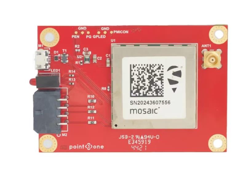
GNSS interface board – mosaic. (Image: Point One Navigation)

GNSS interface board – mosaic. (Image: Point One Navigation)

Point One Navigation and Septentrio have partnered to expand upon the companies’ precision location solutions throughout Western Europe. The new developer compatibility is suitable for demanding applications, including industrial autonomy, precision agriculture, logistics and delivery, robots and autonomous vehicles.

Point One’s Polaris is a correction network that enables high-precision GPS and computer vision-based localization. Polaris has recently extended coverage to now include Western Europe, further expanding the reach of the network. This solution is powered by Septentrio’s GNSS receivers, including the mosaic compact multi-constellation GNSS receiver.

The mosaic module — a multi-band, multi-constellation receiver in a low-power surface-mount module with a wide array of interfaces — is designed for mass market applications such as robotic and autonomous vehicle guidance systems. The module integrates GNSS and RF ASIC technology, as well as the robust positioning engine from Septentrio.

Septentrio real-time kinematic (RTK) receivers can be used directly with Polaris to provide centimeter-level accuracy in seconds.

This technology is complemented by Point One’s FusionEngine software, which further integrates cameras and additional sensors to achieve the desired level of precision — even in the complete absence of satellite signals.

FusionEngine has the accuracy and the resilience to inclement weather required by Level 2 applications, such as highway lane keeping and V2X, while offering the robustness necessary for mission-critical Level 4 and Level 5 robotaxi and full autonomy applications.

Publicerad den Lämna en kommentar

BAE Systems releases GPS receiver

Image: BAE Systems 

Image: BAE Systems

At the Joint Navigation Conference in San Diego, BAE Systems unveiled NavGuide, an assured-positioning, navigation and timing (A-PNT) device featuring M-code GPS technology. NavGuide is a field-installable replacement to the defense advanced GPS receiver (DAGR), designed for quick integration into current DAGR mounts and accessories without mission interruption.

NavGuide features a 3 in, full-color, graphical user interface for dismounted soldiers, and easily integrates with existing mounted platforms and systems. The device leverages the advanced M-code GPS signal with enhanced jamming and spoofing protection.

NavGuide is portable, versatile, and precise, and enables vehicular, handheld, sensor, and gun laying applications that enable the military to defeat adversaries in a variety of challenging threat environments.

For more information on NavGuide, click here.

Publicerad den Lämna en kommentar

Paris Air Show and kamikaze UAVs

Air Mobility Event Illustration. (Image: Paris Air Show)

Air Mobility Event Illustration. (Image: Paris Air Show)

The Paris Air Show

The Paris Air Show rolls out this week, accompanied this year by several urban air mobility (UAM) companies, including Eve Air Mobility with a cabin mock-up of its eVTOL, and demonstrations of its UAM software.

Eve also announced ahead of the show that United Airlines, its major partner, is moving forward with route and infrastructure planning in San Francisco — where such factors as the size of the city and high traffic volume cry out for mobility alternatives.

Eve UAM. (Image: Eve press release)

Eve UAM. (Image: Eve press release)

Emerging as a start-up from within the Brazilian aircraft company Embraer, Eve was eventually floated in 2022 through an initial public offering on the New York Stock Exchange. Given the relationship with Embraer, Eve (in particular, United and other Eve customers) stand to gain access to the worldwide maintenance, support, parts and repair organization that Embraer has developed to support its own passenger fleet of thousands of aircraft. An enviable solution for any current or future purchaser of Eve vehicles — this probably has something to do with their huge order backlog for 2,770 vehicles. All that is required now is the full-scale assembly, ground and flight test, verification and certification of the Eve air mobility aircraft — currently forecast to enable a 2026 entry into service.

Additionally, other UAM companies will be present in a special show exhibit, the “Air Mobility Event,” in Hall 5 in Paris.

Is Ukraine winning the UAV war with Russia?

This is not at all clear, as both sides throw at each other many different UAVs in various configurations with different missions. We tend to only see the Ukraine side of the picture, given that Russia does not generally document its successes in the media.

However, recent news indicates that Moscow is importing Iranian UAV technology to bare in its war with Ukraine. It seems that Iran has been supplying complete kamikaze attack UAVs and may also be assisting with materials to set up an assembly plant near Moscow. Potential one-way attack UAVs include the HESA Shahed 136/Geran-2, the new MERAJ-523 which can carry a 50 kg warhead, and the Mohajer-6 reconnaissance/attack drone.

Last week, Russia unleashed a volley of about 44 UAVs on the capital Kyiv, thought to be Shahed 136 kamikaze UAVs. Ukrainian defenses brought down the majority, but there were still a number of casualties. These attacks on the center of Kyiv are said to have intensified during the last two months — the UAVs are cheap, long range, and carry significant ordinance.

Mohajer-6. (Image: courtesy of the Ministry of Defense of Ukraine)

Mohajer-6. (Image: courtesy of the Ministry of Defense of Ukraine)

The UK is reported to have called Iran’s actions in support of Russia contrary to the nuclear agreements reached between Iran and the European Union in October 2022, which prohibit the supply of any military aid to Russia by Iran.

Not to be left behind, India has brought its own kamikaze UAV online

The ALS-50 loitering munition, built by the Mumbai Tata group, was recently inducted into the Indian Air Force (IAF) for use against targets on the ground (i.e., missile batteries) and on the sea (i.e., ships).

With an apparent range of 1,000 km (62 miles) and a payload of 25 kg (55 lb), the Indian-produced UAV will replace more expensive UAVs, which India has imported from Poland and elsewhere.

With the war in Ukraine on the mind of all countries near the conflict, it is clear that many may take on defense strategies similar to those that have been used by both Russia and Ukraine.

UAV news summed up

So, as the International Paris Air Show, previously a major military exhibition and air show, begins to welcome and feature the coming age of UAM, it is good to see that there are several independent programs that plan to show their wares. Air-taxi services are still some way off from being a reality, as there are still heavy, lengthy investments to be made in building and qualifying these unmanned/manned aircraft for passenger use. Hopefully, however, several of the contenders will make it to the finish line and fulfill the promises made for UAM.

Meanwhile, as the war in Ukraine plods along, taking lives and destroying property, it is good that both sides have decided that UAVs should be the way to proceed. UAVs, after all, are relatively small and the degree of destruction they can cause is limited. Still, this is not very comforting for people on both sides as they run from the sound of two-stroke and four-stroke engines descending from on high, carrying explosive charges that will kill and maim. Additionally, as the West arms Ukraine with defensive materials, it’s not surprising that Russia is seeking weapons from allies, wherever it can find them.

Publicerad den Lämna en kommentar

Harxon releases antennas for lawn mowers

Harxon has released two high-precision GNSS antennas suitable for robotic lawn mowers.

The HX-CSX014A is a high gain, low profile and compact antenna with a new structure that simplifies integration into lawn mowers and minimizes the overall machine dimension. It features small size, high sensitivity and low power consumption.

The HX-CSX231A, is a ready-to-use GNSS antenna with a highly reliable structure that makes it small and lightweight. It exhibits 4.5 dBi high gain performance with ultra-low signal loss. It also delivers wide beam width that covers wide frequencies with high marginal gain, a perfect option in complex environments.

Additionally, the HX-CSX231A’s advanced LNA features improved signal filtering, out-of-band rejection, restrained unwanted electromagnetic interferences and a strong multi-path reduction capacity.

To learn more about Harxon high precision GNSS solutions for lawn mowers, click here.

Image: Harxon

Image: Harxon

Image: Harxon

Image: Harxon

Publicerad den Lämna en kommentar

A missing sub and navigation: What happened to the sub searching for the Titanic?

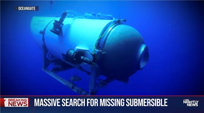
OceanGate. (Credit: Screenshot of NBC news coverage)

OceanGate. (Credit: Screenshot of NBC news coverage)

On June 17, an OceanGate Expedition Titan submersible launched off the coast of Newfoundland, Canada, carrying five passengers to the bottom of the Atlantic Ocean to explore the infamous R.M.S. Titanic shipwreck. The U.S. Coast Guard said that the submersible lost contact with the surface vessel about an hour and 45 minutes after the launch and has not been in contact since.

The submersible can support life for 96 hours. As of the afternoon of June 20, it had 40 hours of oxygen left and U.S. and Canadian agencies were still searching for it.

The Titan submersible explained

According to the OceanGate website, the Titan is “a Cyclops-class manned submersible designed to take five people to depths of 4,000 [m] (13,123 [ft]) for site survey and inspection, research and data collection, film and media production, and deep-sea testing of hardware and software.” The Titan is equipped with an inertial navigation system (INS), an ultra-short base line acoustic positioning system, a robotics laser scanner, a Teledyne 2D sonar and more.

While it is equipped with an INS, the Titan relies on messages from a surface ship to guide the submersible to the shipwreck. The submersible and surface vessel rely on Elon Musk’s Starlink satellites for communication.

A part of the Titan worth mentioning, the crew is sealed inside and bolts are applied to the outside — needing an external crew to remove them upon surfacing.

Foreshadowing

The New York Post reported, in 2022, that an OceanGate Expedition to the Titanic lost contact for more than two hours and never found the wreck.

Aboard the submersible was a CBS correspondent, David Pogue, who was filming a segment for CBS Sunday Morning. He tweeted about the incident.

The future

There are 18 planned expeditions to the Titanic with OcenGate Expeditions to survey the shipwreck, collect data, and document high-resolution images and videos.

The entire trip to the Titanic wreck site takes 8 days, and one dive can take up to 10 hours. The expedition is comprised of five legs.

Publicerad den Lämna en kommentar

Septentrio timing GNSS module now supports Fugro AtomiChron

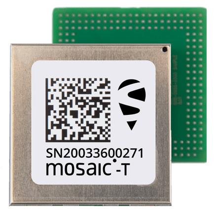
Image: Septentrio

Image: Septentrio

Septentrio’s compact GNSS timing module, mosaic-T, now supports the AtomiChron timing service from Fugro. The mosaic-T module already includes several layers of security against GNSS jamming and spoofing with AIM+ integrated technology and OSNMA Galileo authentication; however, AtomiChron further strengthens the anti-spoofing security of the mosaic-T receiver by offering navigation message authentication on all four major GNSS constellations.

Fugro AtomiChron includes navigation message authentication, which ensures timing resilience through reception of only genuine GNSS signals. The AtomiChron eliminates time drift caused by clocks counting time at slightly different rates. This achieves sub-nanosecond accuracy and provides extreme stability that surpasses current precision frequency standards. This is a lightweight and scalable solution, which removes the need for atomic clocks in critical infrastructure.

The mosaic-T delivers accurate timing with multi-frequency, multi-constellation GNSS technology and offers dedicated timing features and inputs for time and clock synchronization. AtomiChron capability can be obtained via a software upgrade for new receivers or for receivers which are already operational in the field.

The AtomiChron service is optional and can be activated through Fugro. To find out more about mosaic-T or the secure positioning receivers from Septentrio use the Product Finder tool or contact the Septentrio team.

Publicerad den Lämna en kommentar

CHCNAV releases C5 and C30 survey cameras

C5 and C30. (Image: CHC Navigation)

C5 and C30. (Image: CHC Navigation)

CHC Navigation has released the C5 and C30 orthographic and oblique cameras for aerial surveys. The systems are designed to provide high-quality imaging solutions for photogrammetric applications and to complement lidar survey data.

The C5 camera is an efficient and lightweight system for aerial surveys, weighing 290 g for increased flight endurance. Its compact size of 75 mm x 63.5 mm x 102.5 mm allows easy integration into UAVs. The C30 camera’s weight is 600 g with a size of 110mm x 108 mm x 85 mm. The C30 is also designed for aerial surveying.

The C5 and C30 cameras’ universal installation design makes them compatible with a wide range of fixed-wing and rotor UAV platforms. Both cameras are supported by the CHCNAV’s BB4 Mini and P330 Pro UAVs as well as the DJI’s M300 RTK.

The Alphaport (the A-type hardware interface) enables the C5 and C30 to be easily mounted into various UAVs and converted into the DJI Skyport connector for extended compatibility.

The C5 and C30 cameras give maximum flexibility for photogrammetric applications. They can be used independently on real-time kinematic-enabled UAVs to capture high-resolution imagery or installed directly on the CHCNAV’s lidar series to colorize point cloud data. This feature allows seamless imagery and lidar data integration for a more complete view of the surveyed area.

Publicerad den Lämna en kommentar

Research roundup: Autonomous applications in transportation

Image: gorodenkoff/iStock/Getty Images Plus/Getty Images

Image: gorodenkoff/iStock/Getty Images Plus/Getty Images

GNSS researchers presented hundreds of papers at the 2022 Institute of Navigation (ION) GNSS+ conference, which took place Sept. 19–23, 2022 in Denver, Colorado, and virtually. The following four papers focused on autonomous applications in transportation. The papers are available here.

Addressing integrity monitoring of autonomous navigation

There are critical issues for the integrity monitoring of autonomous navigation applications, which include an adequate uncertainty budget in the observation domain, redundancy for the determination of the navigational states, and the capability of fault detection and exclusion.

Several aspects are addressed in the paper, including how to: determine interval bounds to handle GNSS multipath effects in urban environments, realize fault detection and exclusion based on constraint satisfaction and set membership, and improve the detector using weighting models.

The authors of the paper aim to contribute to the alternative integrity approach based on interval and set representations for bounding and propagating system uncertainty. Simulated and real-world experiments are carried out to demonstrate the feasibility of the authors’ proposed methods.

The authors note that statistical evaluation of integrity will not always suffice due to the presence of remaining systematic uncertainty, but state the alternative integrity approach will contribute to future autonomous navigation applications.

Su, Jingyao; Schön, Steffen; “Advances in Deterministic Approaches for Bounding Uncertainty and Integrity Monitoring of Autonomous Navigation.”

Estimation and reference systems in automation

For a high level of automation, estimation is crucial, and to achieve a full and reliable navigation evaluation, a trustable reference system needs to be developed.

Although the presence of a reference system and of an inertial measurement unit with GNSS through the multi-sensor fusion scheme was integrated, in GNSS-denied or challenging environment the navigation solution could not be accurately estimated and still needs to be fixed.

The authors of the paper propose new strategies to better estimate the lidar-based position uncertainty and to update the reference system.

The first strategy proposed involves determining the appropriate position error covariance matrix, based on the Hessian matrix and the scale of covariance obtained from a normal distribution transform (NDT) scan matching technique and the geometric dilution of precision computed from the distribution of point cloud segments in each scan.

In the second strategy proposed in the paper, the updated reference system was post-processed according to the loosely coupled INS/GNSS/NDT integration scheme with a forward and backward smoothing process.
The results of the proposed strategies indicated that the updated reference system provides more reliable navigation estimation compared to an existing reference system from commercial software and can be used for accurate evaluation of positioning, navigation and timing with automated vehicle applications.

Srinara, Surachet; Chiu, Yu-Ting; “Adaptive Covariance Estimation of Lidar-Based Positioning Error for Multi-Sensor Fusion Scheme with Autonomous Vehicular Navigation System.”

Evaluating TerraStar-X

GNSS performance using typical, low-cost GNSS devices in vehicles is not enough to achieve the positioning and availability needed for lane-level accuracy on autonomous vehicles. The antenna and receiver hardware available in standard vehicles limits the position accuracy and convergence performance. These limitations make the positioning more susceptible to error sources such as receiver multipath, noise, carrier tracking and stability.

GNSS correction services with additional design considerations and sophisticated algorithms are needed to work within the constraints of automotive-grade GNSS devices to achieve the performance required for lane-level positioning.

TerraStar X technology from NovAtel enables these applications. It includes an orbit and clock determination system (OCDS), which produces a set of corrections, precise satellite orbits and clocks, and satellite-specific biases for individual signals augmented by the computation of additional regional corrections.

The authors of the paper outline the design and performance of the combined OCDS and regional correction system. They demonstrate the performance of the TerraStar X technology across a variety of applications.
The addition of regional corrections enables automotive and mass-market applications to achieve in-lane positioning in seconds, using any dual-frequency, dual-constellation GNSS hardware. The result is software that provides a continuous stream of multi-constellation, multi-frequency GNSS corrections — enabling a correction service that makes the affordable GNSS device ecosystem possible.

Regional corrections also improve the performance of survey-grade GNSS receivers.

Mervart, Leos; Lukes, Zdenek; Alves, Paul; “TerraStar X Technology: Design of GNSS Corrections for Instantaneous Lane-Level Accuracy on Large Scale Connected Vehicles and Devices.”

Solving the localization problem in autonomous driving

The localization problem in autonomous driving imposes two criteria on the navigation solution: accuracy and reliability or integrity. According to the authors of this paper, solving the localization problem is a key requirement to enabling the development of autonomous platforms.

This paper presents AUTO, a real-time integrated navigation system that tightly integrates INS, GNSS-RTK, odometer, and multiple radars sensors with high-definition maps to achieve a high-rate, accurate, continuous, and reliable navigation solution. It also shows how AUTO leverages a tight integration of imaging radars with other traditional sensors to provide a robust navigation solution with corresponding estimates of the uncertainty.

The AUTO solution was tested in a variety of environments and locations, including a range of conditions such as winter weather, to assure the robustness and reliability required by autonomous applications.

The results demonstrate the lane level accuracy of the solution in a variety of challenging urban and downtown environments. Additionally, the tight integration enables the determination of protection levels to describe upper bounds on the uncertainty.

The results in the paper are illustrated using a Stanford Diagram, along with a user-defined alert limit to describe the solution integrity and availability. The proposed algorithm uses a map matching technique between the imaging radar data and a globally referenced high-definition map to better estimate the solution uncertainty and protection levels.

AUTO’s tightly integrated approach to integrity monitoring means uncertainties and protection levels can be determined even in areas where the system may experience extended periods of GNSS unavailability.

Krupity, Dylan; Chan, Billy; Ali, Abdelrahman; Salib, Abanob; Georgy, Jacques; Goodall, Christopher; “Integrity Monitoring and Uncertainty Estimation with AUTO’s Non-linear Integration of Multiple Imaging Radars and INS/GNSS for Autonomous Vehicles and Robots.”