Publicerad den Lämna en kommentar

GPS circle spoofing discovered in Iran

In March, the U.S. government received an unusual inquiry about GPS disruptions. It was from a user in Iran reporting what appeared to be “circle spoofing” — a phenomenon that had only previously been observed in China.

“Some of GPS devices received fake signal and show the fake valid location. Yesterday I test a device, it can get signal and give real position. After 10 minutes the device show moving around a big circle in tehran by 35 km/h speed. I can’t fix this problem by restarting the device.

“The GPS module time is correct but the location is not. I attach Excel file of data and map of the track. I can’t get any response from Communications Regulatory Authority (CRA) of The I.R. of Iran. Do you know about this?”

Here is one of the images provided by the reporting source:

GPS spoofing device in operation at Iran’s Army Command and Staff College. (Screenshot: Dana Goward)

GPS spoofing device in operation at Iran’s Army Command and Staff College. (Screenshot: courtesy of Dana Goward)

A little internet research showed that the spoofing was taking place at or near Iran’s “AJA University of Command and Staff,” formerly called the “War University.” It is the staff college for Iran’s Army.

Reports to the U.S. government about GPS disruption are normally listed on the U.S. Coast Guard’s Navigation Center website. This one has not been posted. Coast Guard officials said that it is because the report was received by another agency and did not contain sufficient information. Attempts by Coast Guard personnel to contact the reporting source for more information to enable the report to be posted were unsuccessful.

GPS spoofing is often easiest to detect in maritime areas. Ship automatic identification system (AIS) transmissions include location data and are detected by satellite. The data is then aggregated and used by various companies for a number of applications. Viewing ship location reports over time has revealed thousands of ship receivers spoofed to airports in Russia, and hundreds spoofed into circles (presumably around the spoofing device) in China.

Clearly, though, any system that aggregates and displays GPS location data can help detect wide area spoofing activity.

Strava is a mobile app for runners and cyclists. The company aggregates location data and displays it on a heat map to highlight athletes’ favorite routes.

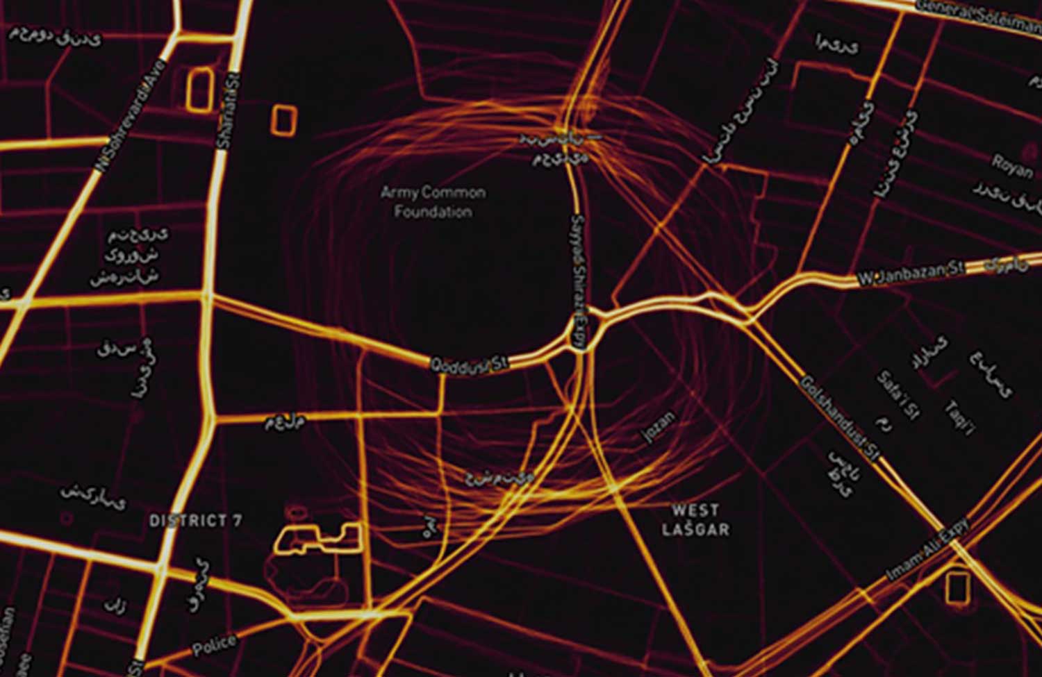
The Strava heat map for Tehran shows that circle spoofing has also been employed in at least one other location. The below screenshot shows GPS-enabled fitness trackers circling a government complex that houses offices for several defense and technology-related organizations.

This heat map shows GPS spoofing at a government complex in Tehran,which houses the Ministry of Defense, Communication Regulatory Authority, Telecommunications Infrastructure Company, and Ministry of Telecommunications and Technology. (Screenshot: Dana Goward)

This heat map shows GPS spoofing at a government complex in Tehran,which houses the Ministry of Defense, Communication Regulatory Authority, Telecommunications Infrastructure Company, and Ministry of Telecommunications and Technology. (Screenshot: courtesy of Dana Goward)

Iran was the first nation to publicly announce it had the ability to spoof GPS signals and seems to have used it to great advantage.

In 2011, a CIA drone that had been operating across the border in Afghanistan landed at an Iranian airfield. Iran’s government claimed that its forces had sent false signals to the drone’s GPS receiver in order to capture it.

At first, U.S. government officials said that this kind of spoofing was not possible. Several months later, Prof. Todd Humphreys demonstrated how it could be done to a drone at the University of Texas football stadium.

U.S. officials then admitted that spoofing was possible, but said it wasn’t what happened to the CIA drone. At the same time, they offered no alternate explanation of how the drone was captured.

In 2016 Iranian forces captured two U.S. Navy boats that had strayed into Iran’s territorial waters. This was just after President Obama had succeeded in pressing that nation to give up nuclear weapons research, and was on the same day as Obama’s last State of the Union address. There was little reason for the U.S. Navy boats to have veered so far off course, and it was clear that the Iranian Navy was waiting for them.

Many speculated that Iran had spoofed GPS signals to lure the U.S. Navy boats into Iranian waters. U.S. officials have denied that this was the cause of the incident, but have not publicly offered an alternate explanation other than “mis-navigation.”

During heightened tensions in the Persian Gulf in 2019, Iran shot down a U.S. surveillance drone and President Trump seemed ready to launch a retaliatory strike. This was called off at the last minute. According to some reports, the strike was canceled because of the likelihood the drone was in Iranian airspace at the time.

At about the same time British intelligence was warning merchant vessels in the area that Iran was attempting to use GPS spoofing to lure them into Iranian waters as a pretext for seizing the ships.

While the Middle East has been a hotbed of jamming and conventional spoofing for years, these recent circle-spoofing incidents are the first of the kind we know of in the region. It may well be that Iranian forces have recently received equipment from China and are experimenting with it. They could also be using it to deter GPS guided drones and disrupt other surveillance systems in the vicinity of sensitive government facilities.


Dana A. Goward is president of the Resilient Navigation and Timing Foundation. The non-profits C4ADS and Skytruth contributed to this article.

Publicerad den Lämna en kommentar

Draganfly conducts pandemic drone tests in US

Draganfly conducted its first series of U.S. pandemic drone test flights in Westport, Connecticut.

Draganfly’s pandemic drone technology is being tested by the Westport Police Department as a new “Flatten the Curve Pilot Program.” According to Draganfly, this initiative is a collaboration of technologies developed by Draganfly, Vital Intelligence, a healthcare data services and deep learning company, and the University of South Australia.

Westport is located in Fairfield County, which has more than 17,550 confirmed cases of COVID-19. Fairfield County is adjacent to New York City, which has the most confirmed cases of coronavirus in the United States.

Image: Draganfly

Image: Draganfly

Westport is deploying the technology and data tools to enhance town services, advance public safety, promote the efficient use of taxpayer dollars, engage residents and encourage growth in the local economy.

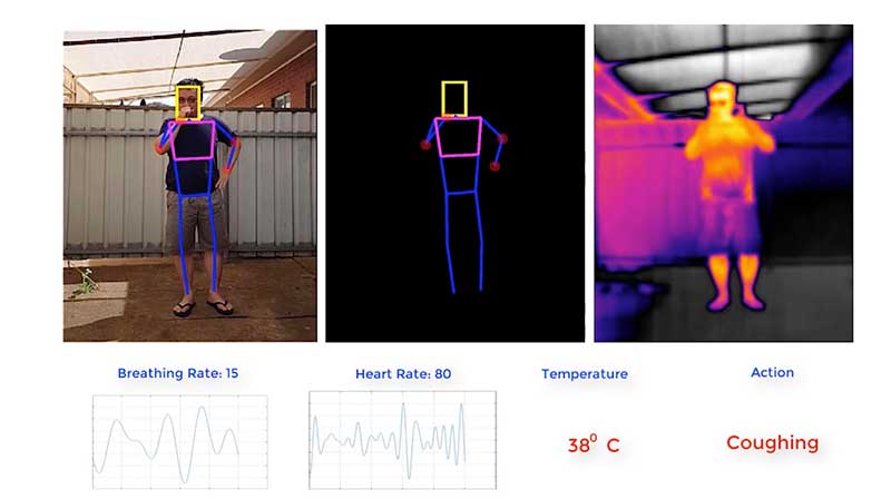
The pandemic drone will be equipped with a specialized sensor and computer vision systems that can display fever/temperature, heart and respiratory rates, as well as detect people sneezing and coughing in crowds, and wherever groups of people may work or congregate. The technology can accurately detect infectious conditions from a distance of 190 feet, as well as measure social distancing for proactive public safety practices, Draganfly said.

Westport specifically plans to use the drone technology to help protect potential at-risk groups, crowds gathering at the town and state-owned beaches, train stations, parks and recreation areas, shopping centers and other areas where people tend to gather.

“One of the major problems for cities and towns like Westport in managing and responding to a pandemic like the COVID-19 virus, is finding out who could be infected and how widespread the disease has spread,” said Jim Marpe, Westport first selectman. “One way to do this is to look for underlying symptoms. By teaming up with Draganfly and the UniSA team, led by Defence Chair of Sensor Systems Professor Javaan Chahl, we are able to remotely look at valuable lifesaving data and better manage current and future health emergencies.”

Draganfly‘s pandemic drone software uses biometric readings in its analysis process. The software can be used to understand patterns within a population to allow users to react quicker to ongoing events or new potential health threats, Draganfly added.

Draganfly manufactures UAVs and UAS, serving the public safety, agriculture, industrial inspections and mapping and surveying markets.


Check out more of GPS World’s coronavirus coverage here.

Publicerad den Lämna en kommentar

Traxens offers smart-container tracking to manage COVID-19 supplies

Photo:Traxens has introduced new pricing for its smart containers tracking system to help global partners manage the challenges presented by the COVID-19 pandemic.

“The COVID-19 pandemic is affecting supply chains across the globe. In a volatile market, supply chains must be resilient and able to adjust quickly and efficiently. Changes to global trade agreements and other factors always create some degree of uncertainty in supply chains,” Traxens stated in a press release. “This year however, COVID-19 has taken supply chain uncertainty to a whole new level.”

Traxens’ smart-container solutions provide real-time visibility into global shipments. Its smart containers and data services give customers key data insights about when, where and why disruptions or delays occur. With accurate insights provided, customers can make quick decisions and collaborate with partners and customers to minimize costs, delays and backlogs.

“If everyone across the supply chain has access to these vital insights, the industry will be better placed to return to normal once the pandemic has been brought under control.”

Publicerad den Lämna en kommentar

New GPS SPS Performance Standard released

CGSIC logo

The U.S. Air Force has released the 5th Edition of the GPS Standard Positioning System (SPS) Performance Standard (PS), according to U.S. Coast Guard Navigation Center (NAVCEN) Civil GPS Service Interface Committee (CGSIC).

With final signature by the U.S. Department of Defense, the standard was cleared for public release on April 16. This is the first update to the SPS PS since 2008 and, for the first time, includes pre-Initial Operating Capability (IOC) performance standards for new civil GPS signals L2C and L5, in addition to L1 C/A.

The SPS PS specifies the levels of SPS performance in terms of broadcast signal parameters and GPS constellation design. According to NAVCEN, the U.S. government is committed to meeting and exceeding the minimum levels of service specified in the SPS PS.

The document can be found at the NAVCEN website and at GPS.gov.

Publicerad den Lämna en kommentar

US small business loans a challenge with COVID-19

Photo: Piotrekswat / iStock / Getty Images Plus / Getty Images

Photo: Piotrekswat / iStock / Getty Images Plus / Getty Images

Small businesses, including many surveyors, are being hit particularly hard by the current economic crisis caused by the measures required to fight the COVID-19 pandemic because most of them do not have large cash reserves.

The CARES Act, signed into law on March 27, contains $349 billion to keep small businesses afloat. The funds are administered by the Small Business Administration (SBA) through participating banks.

Hundreds of thousands of borrowers have been approved for, or received, aid under the so-called Paycheck Protection Program, meant to give small businesses loans that would be forgiven if they were used to pay employees, rent, or mortgage principal. The program is one of four that the SBA is administering as part of the CARES Act.

The other three are the Economic Injury Disaster Loan (EIDL) loan advance, which will provide up to $10,000 of economic relief to businesses that are currently experiencing temporary difficulties; the SBA Express Bridge Loans, which enables small businesses who currently have a business relationship with an SBA Express Lender to access up to $25,000 quickly; and the SBA Debt Relief, which provides a financial reprieve to small businesses during the pandemic.

These programs — an unprecedented challenge for the SBA, which is already struggling with a surge in coronavirus-related loan applications through other programs such as its disaster loan program — were marred by technical and logistical glitches from the start.

On April 16, while many small-business owners were desperately trying to apply for loans, the SBA ran out of the relief money. Its website’s COVID-19 page announced: “SBA is unable to accept new applications at this time for the Paycheck Protection Program or the Economic Injury Disaster Loan (EIDL)-COVID-19 related assistance program (including EIDL Advances) based on available appropriations funding. EIDL applicants who have already submitted their applications will continue to be processed on a first-come, first-served basis.”

As of press time, Congress and the White House are negotiating the possible release of additional rescue funds.

Sources

Publicerad den Lämna en kommentar

Plans to reopen after COVID-19 vary widely

Around the world, countries are cautiously beginning to reopen businesses and activities they had shut down to limit the spread of the coronavirus.

Countries

Austria will reopen some smaller shops, hardware and garden stores but people will have to wear masks to supermarkets and on public transport. From May 1, all stores, shopping centers and hairdressers will open; restaurants and hotels will open from mid-May at the earliest.

China has largely removed restrictions on mobility while tightening policy to contain the virus transmission of asymptomatic cases.

The Czech Republic on April 6 allowed shops such as hardware and bicycle stores to re-open. Outdoor sports facilities have also reopened. Starting on April 20, students will begin a phased return to colleges and schools, but high schools are not expected to fully open until September 1. From June 8, all retail stores, including those in shopping centers, all restaurants, hotels and other accommodation will be allowed to reopen.

Denmark will reopen daycares, kindergartens and schools (up to 5th grade) on April 22, while other bans, such as on gatherings of more than 10 people, will remain in place until May 10. Churches, cinemas and shopping centers will remain closed. All festivals and large gatherings are banned until August.

Germany will allow stores with a sales area of less than 800m2 to reopen on April 20 if they maintain hygiene and prevent lines from forming. Schools with hygiene plans in place will gradually reopen from May 4, with priority given to primary and secondary pupils in final years, while daycare centers will remain shut. Other social distancing measures, along with bans on large public events, will remain in place.

India has extended what is currently the world’s biggest lockdown through May 3.

Italy allowed bookstores, laundries, stationery stores and children’s clothing stores to reopen on April 14. “Phase 2” of the three-phase reopening plan will start sometime after May 3. Businesses that reopen will be required to make hand sanitizer available, enforce the use of masks in enclosed spaces, and use disposable gloves to handle food and drink.

Japan has tightened its approach, declaring a state of emergency in Tokyo, Yokohama and Osaka, the country’s three biggest cities.

Norway is prioritizing reopening schools and will begin to scale back its lockdown measures from April 20, when kindergartens will start to reopen. A week later, schools will reopen for pupils in grades one to four.

Spain allowed many non-essential employees to return to work after the Easter weekend. Construction and other industries have been allowed to restart, but non-essential stores, bars, and restaurants remain closed. Spanish police are distributing more than 10 million masks to commuters at metro, bus, and train stations.

Switzerland has extended social distancing restrictions to April 26, but might relax other measures later this month, including border controls, school closures and bans on gatherings, if the virus’ spread is kept in check.

United States reopenings vary by state

If you cannot resist the urge to eat at a restaurant or have a drink at a bar during this pandemic without leaving the United States, head for South Dakota, the only state that has not banned these activities except for take-out.

However, unless you live in neighboring Iowa, Nebraska, or North Dakota, you will be most likely breaking the law of one of the 39 states that have banned travel that is not deemed essential or to get to work (five of them with exceptions or limitations). South Dakota and Arkansas have no travel bans and the remaining six states have a variety of advisories and bans targeted at various classes of people, such as those over 70 years old.

As for gatherings, 27 states restrict them to ten people or fewer, four states to nine people or fewer, and five states allow no gatherings at all. Only two states, North Dakota and Minnesota, have not banned any gatherings.

Twenty-five states have limited all nonessential businesses to minimum operations or remote work, three have closed all nonessential businesses, and only two states — again, Nebraska and South Dakota — have not restricted any business activity.

Finally, while 27 states have no state-wide quarantines, the remaining 23 have a bewildering array of quarantine rules for travelers depending on where they have been. However, the duration of the quarantine is always 14 days.

Photo: Kameleon007 / iStock / Getty Images Plus

Photo: Kameleon007 / iStock / Getty Images Plus


Sources

*Laura Smith-Spark and Emma Reynolds, “These countries are reopening after coronavirus — here’s how they’re doing it,” CNN, 2020.04.16

Patrick Kingsley, “Some European Nations Ease Pandemic Rules, but Move Warily: The lifting of restrictions is an early test of whether democracies can restart their economies and restore basic freedoms without refueling the spread of the coronavirus.” The New York Times, 2020.04.14

International Monetary Fund, POLICY RESPONSES TO COVID-19, last updated on 2020.04.10

Ryan Heath, “How does the world end the coronavirus lockdown? Countries can’t agree on exit strategy. There are no global benchmarks and little coordination when it comes to opening up national economies.Politico, 2020.04.15.

Publicerad den Lämna en kommentar

FCC approves Ligado broadband network, DOD and GPS industry react

The five-member Federal Communications Commission (FCC) voted unanimously to approve an order to allow Ligado Networks to deploy a low-power nationwide 5G network.

The approval comes despite objections from the U.S. Defense Department (DOD), other federal agencies and major U.S. airlines, all of whom are concerned about near-band interference with GPS.

The FCC said the approval order included stringent conditions aimed at ensuring GPS would not experience harmful interference.

“After many years of consideration, it is time for the FCC to make a decision and bring this proceeding to a close,” said FCC Chairman Ajit Pai in an April 16 news release. “We have compiled an extensive record, which confirms that it is in the public interest to grant Ligado’s application while imposing stringent conditions to prevent harmful interference.”

Ligado is seeking to repurpose a swath of L-band spectrum for a 5G network focused mainly on connecting smart devices and other internet-of-things services. According to the FCC, the order will “promote more efficient and effective use of our nation’s spectrum resources and ensure that adjacent band operations, including the Global Positioning System (GPS), are protected from harmful interference.”

In response, members of both the Senate and House Armed Services Committees and other defense advocates are considering legislative action to overturn the order.

Defense & Transportation departments object

Photo: gorodenkoff/iStock / Getty Images Plus/Getty Images

Photo: gorodenkoff/iStock / Getty Images Plus/Getty Images

Two areas that rely heavily on the integrity of GPS signals include defense and transportation. The DOD issued a joint statement with the Department of Transportation (DOT) criticizing the FCC ruling.

“Americans rely on our Global Positioning System (GPS) each day for many things: to locate citizens in need of emergency assistance through our E-911 system, to secure our financial system, to order and receive shipments, to travel by car for work and leisure, to facilitate commercial trucking and construction work, and even to make a simple cellphone call. Our departments rely on GPS each day for all those reasons as well to coordinate tactical national security operations, launch spacecraft, track threats, and facilitate travel by air and sea. The proposed Ligado decision by the Federal Communications Commission will put all these uses of GPS at risk.”

House Armed Services Committee Chairman Adam Smith (D-Wash.) released a letter he sent to Defense Secretary Mark Esper and FCC Chairman Ajit Pai raising concerns about Ligado’s 5G network.

“While the United States must be a leader in the implementation of 5G networks, our creation of these networks must not hamper our military’s operational capacity in any way. China’s aggressive, global promotion of its 5G companies presents a considerable security challenge that must be addressed. However, Ligado’s proposal, which seeks a portion of spectrum adjacent to that used for Global Positioning Systems, poses an even larger security risk.

“The Department of Defense has been clear and direct: providing this license to Ligado would cause unacceptable operational impacts and adversely affect the military’s use of GPS. The military’s seamless use of GPS is vital to our national security. Our service members rely on GPS satellites for critical precision timing and navigation, and thousands of weapons systems are embedded with GPS signals.

“While I strongly support development of the world’s most robust, safe and secure network, using L-band spectrum in such close proximity to critical GPS, as Ligado’s proposal requires, carries an unacceptable risk that far outweighs the possibility of a 5G network.”

‘Risk of crippling’ GPS

Defense Secretary Mark Esper said via Twitter on Friday that the “Ligado proposal would needlessly imperil GPS-dependent national security capabilities. The Department continues to support domestic 5G options, but not at the risk of crippling our GPS networks. Nearly a dozen other federal agencies have joined us in opposing this proposal.”

In to the FCC news release, Pai stated:

“Although I appreciate the concerns that have been raised by certain Executive Branch agencies, it is the Commission’s duty to make an independent determination based on sound engineering. And based on the painstaking technical analysis done by our expert staff, I am convinced that the conditions outlined in this draft order would permit Ligado to move forward without causing harmful interference. For example, the draft order would authorize downlink operations at a power level that represents a greater than 99% reduction from what Ligado proposed in its 2015 application.”

Image: A-Digit/DigitalVision Vectors/Getty Images

Image: A-Digit/DigitalVision Vectors/Getty Images

The release also provided this background about the Ligado proposal, and the “conditions” under which the FCC decided to approve it.

In recent years, Ligado has amended its application to significantly reduce the power levels of its base stations from 32 dBW to 9.8 dBW (a reduction of 99.3%). Ligado has also committed to providing a significant (23 megahertz) guard-band using its own licensed spectrum to further separate its terrestrial base station transmissions from neighboring operations in the Radionavigation-Satellite Service allocation. As such, Ligado is now only seeking terrestrial use of the 1526-1536 MHz, 1627.5-1637.5 MHz, and 1646.5-1656.5 MHz bands. The Order is conditioned to reflect these technical requirements. It also requires Ligado to protect adjacent band incumbents by reporting its base station locations and technical operating parameters to potentially affected government and industry stakeholders prior to commencing operations, continuously monitoring the transmit power of its base station sites, and complying with procedures and actions for responding to credible reports of interference, including rapid shutdown of operations where warranted.

However, The decision “appears to ignore the well-documented views of the expert agencies charged with preserving the integrity of GPS, specifically on the critical issue of what constitutes harmful interference to users of Global Navigation Satellite Systems (GNSS),” said J. David Grossman, executive director of the GPS Innovation Alliance (GPSIA). He continued,

Headshot: J. David Grossman

J. David Grossman

“GPSIA has consistently advocated for adoption of the 1-dB Standard as the only reliable mechanism that provides the predictability and certainty to ensure the continuation of the GPS success story, with the support of the Department of Defense, the Department of Transportation and numerous other federal agencies. The 1-dB Standard for radiofrequency-based services is critical for GNSS. The FCC’s press release refers to conditions placed on Ligado’s application to prevent harmful interference, and GPSIA and its members intend to carefully review the details of today’s order while continuing to vigorously advocate for promoting, protecting and enhancing GPS.”

Ligado Networks President and CEO Doug Smith issued this statement in reaction to the approval.

“Ligado thanks the Commissioners for moving promptly to approve the order regarding our applications. We greatly appreciate their unanimous support as well as the expert engineering analysis determining that a terrestrial network can be deployed in the L-band to advance our country’s economic and security interests while fully protecting GPS. Our spectrum can be very instrumental in the transition to 5G, and we look forward to utilizing satellite and terrestrial services to deploy customized private networks and deliver innovative, next-generation IoT solutions for the industrial sector.”

Positive reactions to the decision

On April 20, the FCC released a compilation of responses to the decision, all of them in support.

Attorney General Bill Barr: “I applaud FCC Chairman Pai’s proposal to make available L-band spectrum, to be used together with C-band spectrum, for deployment of advanced wireless services, including 5G. As I said in my speech at the Center for Strategic and International Studies, swift FCC action on spectrum is imperative to allow for the deployment of 5G. This is essential if we are to keep our economic and technological leadership and avoid forfeiting it to Communist China.” (Statement, 4/16/2020)

Secretary of State Mike Pompeo: “I commend Federal Communications Commission (FCC) Chairman Pai’s draft order that would release the L-Band spectrum. Quick action on this order, in conjunction with the allocation of a portion of the C-Band for 5G, is vital to our national security and will help ensure that the United States is the global leader in advanced technologies such as AI, the Internet of Things, edge computing, and the next generation of telemedicine. Accelerating the deployment of 5G is essential to our country’s growth, and global economic security.” (Statement, 4/16/2020)

Sen. Ron Johnson (WI): “In a time when connectivity is and will continue to be more important than ever, it’s great to see @AjitPaiFCC move forward with freeing up critical spectrum resources for #5G.” (Tweet, 4/16/2020)

Sen. Mark Warner (VA): “As the U.S. works to lead the world in 5G innovation and promote wider high-speed internet coverage, it’s all the more important to put our valuable mid-band spectrum to use. I urge the @FCC to follow the Chairman’s lead and approve Virginia-based @LigadoInsights’s application.” (Tweet, 4/16/2020)

Rep. Billy Long (MO): “I applaud @AjitPaiFCC and the @FCC for taking action to unlock vital L-band spectrum that has been held hostage by bureaucratic slow-walking for far too long. Jobs and 5G is a win-win for the country.” (Tweet, 4/16/2020)

Rep. Doris Matsui (CA): “I called on the @FCC to move forward with new, innovative uses of L-band spectrum to advance 5G. Glad to see the Commission take action on this front today to encourage efficient use of our spectrum.” (Tweet, 4/16/2020)

Former Rep. Bob Barr (GA): “Federal Communications Commission Chairman Ajit Pai’s decision to circulate a draft FCC Order would at long last move forward the process of opening up a segment of mid-band satellite spectrum for commercial use in 5G technology deserves praise. … If adopted by the five-member Commission headed by Pai, the draft Order would tangibly signal to the country and the world that the United States is committed to seize the leadership in deployment of 5G technology, a role China openly covets.” (Statement, 4/16/2020)

American Action Forum: “More good news from the FCC! 5G is incredibly important and this is yet another example of actions that will enable innovation in 5G and support the growing number of connected devices.” (Tweet, 4/16/2020)

American Enterprise Institute Visiting Scholar Mark Jamison:  “@FCC approval of Ligado petition should accelerate 5G, bring diversity to marketplace, and increase efficient spectrum use. … Good leadership and bipartisan effort!”  (Tweet, 4/20/20)

American Enterprise Institute Visiting Scholar Roslyn Layton: “Kudos @AjitPaiFCC for unlocking more vital mid-band spectrum for #5G. Record of 10 years shows @LigadoNetworks took many steps with agencies and firms to address potential issues with GPS. We must move quickly on 5G!” (Tweet, 4/16/2020)

Citizens Against Government Waste: “The FCC has the engineering expertise to determine the best use of this spectrum and whether alternative uses would cause undue interference. The adoption of the Chairman’s draft order will promote 5G and IoT development, while providing the necessary safeguards for services using adjacent bands, including GPS positioning. … The L-band would not be used at all for the foreseeable future unless the FCC takes action. Freeing up the spectrum requested by Ligado will not only expand the use of 5G, it will also help to prevent other countries, particularly China, from getting ahead of the U.S. in 5G deployment.” (Blog, 4/17/2020)

Competitive Carriers Association: “[We] commend Chairman Pai for circulating a draft order to approve Ligado’s applications, which will make much-needed mid-band spectrum, specifically L-band spectrum, available for terrestrial use. This long-awaited, positive progress comes at a critical time for all Americans, particularly those in rural areas, who are relying on mobile connections and services more than ever before. Mid-band spectrum provides real opportunities for deploying next-generation technologies, and competitive carriers are eager to access this valuable resource to expand and enhance their networks.” (Statement, 4/16/20)

Competitive Enterprise Institute: “Access to spectrum is crucial for our modern economy, connecting everything from radios, to cellphones, to satellites. But for too long, turf-wars between federal regulatory agencies have left spectrum bands largely unavailable for valuable commercial applications. Today’s FCC decision wrests spectrum away from bureaucratic waste and delivers it into the hands of people who will aide our economic recovery and resiliency in the aftermath of the COVID-19 pandemic.” (Statement, 4/16/2020)

CTIA—The Wireless Association: “We’re pleased to see that the FCC has managed to cut through the red tape to make a decision on Ligado. This multi-year process reveals the challenges at play in our nation’s spectrum policy and the need for stronger support for new commercial wireless services. We need to all learn lessons from this process and ensure that decisions on key spectrum bands like lower 3 GHz occur in a more expedited and collaborative manner.” (Statement, 4/16/2020)

FreedomWorks: “Freeing up broadband spectrum will make America a global technological leader and will lead to innovations and developments that will improve quality of life across the country. Chairman Pai and the FCC should be applauded for their work resolving these matters[.]” (Blog, 4/15/2020)

Free State Foundation: “Chairman @AjitPaiFCC has made a commendable decision to act on @LigadoNetworks’ proposal to put L-band spectrum into use for next-gen wireless services. This move takes seriously the @FCC’s responsibility and the urgent need for more commercial spectrum.” (Tweet, 4/16/2020)

Georgetown Law Institute for Technology Law & Policy Distinguished Fellow Gigi Sohn: “This decision was a long time coming, but it’s the right one. … Kudos to @AjitPaiFCC for having the fortitude to move this forward.” (Tweet, 4/16/2020)

Information Technology & Innovation Foundation: “Great to see @FCC taking steps to finally approve @LigadoNetworks waiver for terrestrial use of their spectrum. This will be a boon to industrial IoT connectivity, bringing more productivity, safety, and resiliency for users of the network.” (Tweet, 4/16/2020)

International Center for Law & Economics: “Promoting deployment of 5G & next-gen IoT devices means finding new ways for incumbents to responsibly operate in ever-closer proximity. The @FCC’s Ligado order does that. Credit to @AjitPaiFCC for finding a way fwd that promotes innovation while limiting the risk of interference.” (Tweet, 4/16/2020)

Lincoln Network: “Access to spectrum is an essential feature in any working 5G plan. Frankly, one key barrier in opening up this vital resource is government’s stronghold on ‘beachfront’ spectrum whether they own it or not. … This proceeding has been in regulatory limbo for several years due in large part to government stakeholders’ speculative interference claims regarding GPS-applications. … The FCC’s draft order in this proceeding provides enough protection for incumbents in adjacent bands, adds more competition into the 5G-IoT space, and allows consumers to have more access to broadband. Everybody wins.” (Blog, 4/16/2020)

Mercatus Center Senior Fellow Brent Skorup: “Too often new tech is stalled by FCC regulation and incumbents. Chairman Pai pledged to breathe new life into Sec. 7. It’s great to see Chairman Pai and the FCC act on that pledge, liberalize spectrum, and expedite the deployment of new wireless services.” (Tweet, 4/16/2020)

National Security Institute: “Big move by @FCC Chairman @AjitPaiFCC today to support US 5G availability. This is a key nat sec issue w/ threat posed by China + econ benefits of broad 5G deployment in US.” (Tweet, 4/16/2020)

New America Foundation’s Open Technology Institute: “Kudos to @AjitPaiFCC @FCC for again standing up to Fed agencies trying to hoard spectrum they are not using – or, in this case, which is licensed to @LigadoNetworks! A big plus for #5G wireless ecosystem if it’s built out.” (Tweet, 4/16/2020)

R Street Institute: “If you can change your business model to be more productive and profitable, without hurting anyone else, then regulations shouldn’t stand in your way. Well done, @FCC!” (Tweet, 4/16/2020)

Progressive Policy Institute: “We applaud the FCC’s ongoing efforts to accelerate the deployment of 5G. Repurposing this commercial spectrum for a mobile broadband network is another step in the right direction.” (Tweet, 4/16/2020)

Public Knowledge: “The Chairman’s proposed Order reveals how the FCC has worked to both protect incumbent GPS users while allowing for pro-competitive commercial licensing of spectrum. … Congress has entrusted the FCC to strike the proper balance between the needs of incumbents and the potential benefits to new entrants or new users, and here, the FCC gets it right. In approving Ligado’s license, the FCC has taken an important step forward in its role as the sole arbiter of spectrum disputes and, in this instance, has correctly sided on behalf of the public interest to help deliver the potential of 5G to more Americans.” (Statement, 4/16/2020)

Technology Policy Institute: “Allowing the Ligado spectrum to lie fallow would represent a waste of valuable resources that could provide substantial benefits for consumers in the form of new Internet of Things and other uses. … Failure to approve the Ligado license modifications would have the opposite effect, transferring a large block of spectrum from the commercial sector back to the government. The Commission’s action today will avoid that outcome.” (Statement, 4/16/2020)

Wireless Infrastructure Association: “WIA applauds Chairman Pai for circulating a draft order to approve Ligado’s plans to deploy a nationwide network that would primarily support 5G and IoT services. After years of diligence, study, and discussion, today’s action is further evidence that the FCC bases its decisions on science and engineering. Freeing up more spectrum, especially mid-band spectrum, is vital to 5G deployment. Ligado’s proposal offers an enormous opportunity for infrastructure investment, deployment, and connectivity for Americans across the country right when we need it most.” (Statement, 4/16/2020)

Publicerad den Lämna en kommentar

3 more conferences postponed due to COVID-19

Three more conferences, including AIxSPACE, the European Navigation Conference and the Connected & Autonomous Vehicles Conference, have been rescheduled for the fall due to the coronavirus pandemic.

AIxSPACE, originally scheduled for June 1, has been rescheduled to take place Nov. 2. The conference, formed by Euroconsult and Innovitech, will bring together stakeholders in space and artificial intelligence industries to allow everyone to obtain concrete information on these markets and connect with potential business partners. It will still be taking place in Montreal, Québec, Canada.

The European Navigation Conference has been rescheduled for Nov. 22-25. According to show organizers, the conference will bring together scientists, engineers and international experts to discuss new ideas, latest research results, future developments and new applications. The European Navigation Conference event will still be taking place in Dresden, Germany.

Finally, the Connected & Autonomous Vehicles Conference will now be taking place Aug. 10-13 at the San Jose Convention Center in San Jose, California. This conference will explore the latest industry developments. In addition, attendees will hear thought-provoking case study presentations from top automakers.

Check out more show updates as a result of the coronavirus pandemic here.

Publicerad den Lämna en kommentar

NSGIC issues joint statement on value of GIS for COVID-19 pandemic

Image: Kat72/iStock / Getty Images Plus/Getty Images

Image: Kat72/iStock / Getty Images Plus/Getty Images

The National States Geographic Information Council (NSGIC) has released a joint statement on the value of GIS in the pandemic, alongside its partners the MidAmerica GIS Consortium (MAGIC), Open Geospatial Consortium (OGC), Urban and Regional Information Systems Association (URISA), and American Association of Geographers (AAG).


Joint Statement on the Value of GIS in the Pandemic

The spread and effects of COVID-19 can be best understood considering space and time.

As governments are responding to COVID-19, more leaders are recognizing the value of “knowing the where.” The importance of knowing where the outbreak is growing, where high risk populations are, where the hospital beds and important medical resources are, and where to deploy resources is essential. “Knowing the where” informs better decision-making.

In an effort to better understand the where, governments are recognizing the value of geospatial information and technologies and are engaging geospatial professionals to help them better understand the where to help them in their decision-making and response.

Geospatial professionals bring unique analytical and visualization skills to the table that help responders and decision-makers visualize where the pandemic is spreading more quickly and can make the important decisions regarding where response and resource needs need to be focused. The value of telling the story through a map coupled with a geospatial dashboard provides a view of the event not readily seen in a table such as a spreadsheet.

Beyond visualizing existing data, we can connect data from a location perspective, which enhances the value of the data sources being integrated. Equally important in this event is data on COVID-19 cases and testing packaged and shared in a way useful to scientists.

GIS (geographic information systems) is experiencing an unprecedented level of use. Historically, GIS was deployed following a disaster to help respond and recover. Today, GIS is used as a disaster is unfolding. The COVID-19 event is an outstanding example of how effective GIS is when robust data is available. Governments are realizing the value of investing in these systems and the people who run them.

The information necessary to empower all partners already exists.

Current nationwide models and response efforts may not benefit from the details of local geographic parameters. Local or statewide models and response efforts may not fully take advantage of the data from other areas of the country. Hospitals are surveyed by both federal and state agencies, and the results of those surveys are not readily available to the hospitals working together to care for patients. Nationwide geospatial data will empower a coalition of participants with a better understanding of the spread and impacts of COVID-19 and improve mitigation actions.

The same data can be made available in different forms to empower people playing different roles in the response. Researchers — epidemiologists — will benefit from nationwide COVID-19 testing data and data describing factors impacting the spread. This data needs to be as disaggregated as permissible under HIPAA and in a form readily digestible in models.

The case data could be aggregated to the same units of geography as a wealth of existing demographic data (Census tracts), which could explain and quantify local variances in the spread. Policy makers and those in emergency management can benefit from map and tabular dashboards, harnessing the power of the where by integrating data for analytics.

The emergency response, public health and geospatial communities must come together to understand COVID-19 in the U.S. and mitigate its spread and overall impact.

By geo-enabling public health and emergency response data, we can better:

  • understand the spread — with COVID case data, movements of people, and symptoms
  • understand the impact on individuals — with data including age, disease, obesity, and medical treatments
  • understand how to tailor outreach — by age, language, engagement with government, and lifestyle choices
  • understand the needs of the healthcare industry — by facility, day, bed capacity, type of care, ventilators, and PPE
  • understand the impact on the local economy — by county, day, unemployment, and bankruptcies
  • understand the societal impacts — by census tract, domestic violence, alcohol consumption, child abuse, animal abuse, elder abuse, mental health crises, 3-1-1 calls and firearm sales

We are committed to beginning the national conversation about leveraging the best available data to better understand the spread and impacts of COVID-19.

To receive more information and be part of the discussion, please share your email address with us.

National States Geographic Information Council (NSGIC)

MidAmerica GIS Consortium (MAGIC)

Open Geospatial Consortium (OGC)

Urban and Regional Information Systems Association (URISA)

American Association of Geographers (AAG)


Feature image: Kat72/iStock / Getty Images Plus/Getty Images

Publicerad den Lämna en kommentar

2 SOPS disposes last GPS IIA satellite after 26 years

News by Airman 1st Class Jonathan Whitely
50th Space Wing Public Affairs Schriever Air Force Base

The 2nd Space Operations Squadron at Schriever Air Force Base, Colorado, initiated the disposal of the last operational GPS IIA satellite, satellite vehicle number 34, April 13-20.

The GPS satellite program currently uses 31 satellite vehicles to transmit precise position, navigation and timing signals to more than 6 billion users around the world. To support the Air Force’s GPS III modernization efforts, 2nd SOPS operators phase out older models to make room for the new GPS III satellites.

The disposal of SVN-34 marks the end of a 26.5-year era in which the satellite outlived its 7.5-year design life by 19 years.

“As we continue to manage the influx of GPS III (the newest iteration of GPS satellites) and maintaining other vehicles in a residual status, we have to be cognizant of effective risk management,” said Capt. Angela Tomasek, 2nd SOPS GPS mission engineering and analysis flight commander. “As SVN-34 continued to age, we had to manage its aging components and likelihood of having a critical malfunction. We are at a stage where we are confident in the robustness of the overall GPS constellation to remove the last remaining IIA vehicle.”

Disposal process. Units conduct satellite disposals when a satellite reaches the end of its operational life and no longer requires daily caretaking and maintenance.

“We push the satellite vehicle to a higher, less congested, ‘disposal orbit’ to eliminate the probability of collision with other active satellites,” Tomasek said. “[Then,] the vehicle is put into a safe configuration by depleting the leftover fuel and battery life and shutting off the satellite vehicle transmitters so no one else can access the satellite in the future.”

Once SVN-34 is in its final orbit, 2 SOPS will on April 20 hand over full tracking responsibility to the 18th Space Control Squadron at Vandenberg Air Force Base, California, where it will be treated and cataloged like every other space object.

“This disposal marks the end of an era in GPS history,” said Lt. Col. Stephen Toth, 2nd SOPS commander. “There are senior leaders and long-time contractors [who] launched and operated the IIA satellites at the beginning of their careers [who] are nowhere to see it end. It is an opportunity to reflect on the legacy and heritage of 2 SOPS and GPS to see how far we have come.”


Feature image: Artist’s depiction of a GPS IIA satellite in orbit. (Image: USAF)