Publicerad den Lämna en kommentar

NCDOT initiative use drones for COVID-19 relief efforts

Photo: Shutter2U/iStock / Getty Images Plus/Getty Images

Photo: Shutter2U/iStock / Getty Images Plus/Getty Images

The North Carolina Department of Transportation (NCDOT) is working with public and private partners to launch three projects using drones to aid in COVID-19 relief efforts. According to NCDOT, the initiative will be launched in May.

For the first project, Novant Health and Zipline are proposing to deliver personal protective equipment and other medical equipment across Novant Health’s medical campuses in the Charlotte area.

For the second project, UPS Flight Forward and Matternet are proposing to work with a Winston-Salem hospital on an operation to use drones to take healthcare equipment, medicine and personal protective equipment to medical providers. UPS Flight Forward, which earned the necessary federal certifications to operate a drone airline, has an ongoing drone delivery service at WakeMed’s main campus in Raleigh, NCDOT said.

Finally, for the third project, Flytrex is proposing to deliver food from multiple restaurants in a shopping center to neighborhoods in the Holly Springs area.

The first two programs are aimed at reducing the strain on medical supply chains, and the third will make it easier for people to follow the stay-at-home order. According to NCDOT, officials will use data collected during the project to determine how this technology can be used in other areas of the country.

“North Carolina has been a leader in demonstrating how drones can help people in times of crisis,” said State Transportation Secretary Eric Boyette. “We look forward to putting this technology into productive use as we work to help citizens and medical professionals during the COVID-19 pandemic.”

Funding for the individual drone missions is coming from private partners, while NCODT is coordinating the initiative.


Read more of GPS World‘s coronavirus coverage here.

Publicerad den Lämna en kommentar

Inertial Labs releases 2-axis, 3-axis gyroscopes

Inertial Labs' TAG-200 two-axis and TAG-300 three-axis gyroscopes are designed for use in harsh environments. (Photo: Inertial Labs)

Inertial Labs’ TAG-200 two-axis and TAG-300 three-axis gyroscopes are designed for use in harsh environments. (Photo: Inertial Labs)

Inertial Labs has released its TAG-200 two-axis and TAG-300 three-axis gyroscopes, developed for electro-optical systems, gimbals, line-of-sight, and pan and tilt platforms for stabilization and pointing applications.

According to the company, TAG-200 and TAG-300 utilize advanced performance, tactical-grade MEMS sensitive elements, of which size, power consumption, reliability and performance are ideal for accomplishing complex tasks requiring accurate stabilization of assorted platforms.

The gyroscopes, designed for use in harsh environments, can withstand extreme shock and vibration in accordance with MIL-STD-810 ground mobile use, Inertial Labs added. In addition, they are fully digitized, include built-in test functionalities and have no moving parts.

Key advantages of the dual TAG-200 and triple TAG-300 axis gyroscopes include low noise, low latency, wide bandwidth, high data rate, low bias drift, low VRE, high MTBF and ITAR-free, Inertial Labs said. The gyroscopes are factory calibrated over operational temperature range with low non-orthogonality and misalignment between sensitive elements. They’re also QA/QC tested and supplied with individual calibration and acceptance test certificates.

Inertial Labs, based in Paeonian Springs, Virginia, manufactures orientation and navigation sensor solutions.

Publicerad den Lämna en kommentar

Horizon realizes benefits of WAAS; Delta lands GLS approach in Dominican Republic

Photo: Federal Aviation Administration

Photo: Federal Aviation Administration

Horizon realizes benefits of WAAS

More than a decade ago, Horizon Air, a regional affiliate of Alaska Airlines, decided to implement the Wide Area Augmentation System (WAAS) as a part of its overall solution.

According to the Federal Aviation Administration’s (FAA) SatNav News winter 2020 newsletter, the airline has identified a number of benefits from implementing the WAAS, including pre-departure planning, enhanced safety and scheduled reliability.

“Our schedule reliability has become the best in our route structure due to the lowest possible approach minimums at airports Horizon Air serves,” said Perry Solmonson, Horizon Q400 check airman/flight ops duty officer.

Delta lands GLS approach in Dominican Republic

On Oct. 16, 2019, Delta 737 pilots, Captain Jon Hensler and Captain C.E. “Noah” Flood, along with 737NG Technical Manager Mike Mannino, conducted a GBAS Landing System (GLS) approach in Punta Cana, Dominican Republic. According to the FAA SatNav News newsletter, the GLS landing was a first for a North American carrier operating a revenue flight into Latin America.

The Punta Cana airport is the first Latin American airport with GLS capability. GLS approaches at this airport permit significantly lower operational weather minimums, allowing aircraft to safely operate into this airfield when they would otherwise need to divert.

According to the newsletter, the approach was the beginning of a several month Delta trial for GLS approaches at the Punta Cana airport.

Check out the full stories in the FAA SatNav News winter 2020 newsletter here.

Publicerad den Lämna en kommentar

An overview of GPS/GNSS shows canceled or postponed because of COVID-19

Several GPS/GNSS-related trade shows and conferences have been canceled or postponed because of the coronavirus pandemic. Get an overview of these shows so far, starting with the most recent updates.

Esri User Conference: virtual conference

Logo: Esri

The Esri User Conference, which typically takes place every July in San Diego, will be held virtually July 13-15. The plenary session, technical workshops and Esri Showcase will be virtual, featuring demonstrations and live discussions during the conference.

Read more about the virtual conference here.


AIxSPACE: postponed

AIxSPACE will now be taking place Nov. 2 in Montreal, Québec, Canada. According to show organizers, AIxSPACE brings together stakeholders in space and artificial intelligence industries to allow everyone to obtain concrete information on these markets and connect with potential business partners.

Read more about the conference here.


ENC logo

European Navigation Conference: postponed

The European Navigation Conference has been rescheduled to take place Nov. 22-25 at the Maritim Hotel & Internationales Congress Center in Dresden, Germany. The conference, hosted by the German Society for Positioning and Navigation, brings together scientists, engineers and international experts to discuss new ideas, latest research results, future developments and new applications.

Read more about the conference here.


Connected & Autonomous Vehicles Conference: postponed

The Connected & Autonomous Vehicles Conference has been postponed and will now be taking place Aug. 10-13 at the San Jose Convention Center in California. The conference aims to highlight the latest automotive industry developments, as well as allow participants to engage with experts and form strategic alliances.

Read more about the conference here.


Logo: ION

ION Joint Navigation Conference: postponed

The Institute of Navigation’s (ION) Joint Navigation Conference (JNC) has been rescheduled for Sept. 8-11 at the Northern Kentucky Convention Center. JNC is a U.S. military positioning, navigation and timing conference with joint service and government participation. According to ION, the rescheduled conference will host the original program, which was scheduled to take place in June.

Read more about the conference here.


36th Space Symposium: postponed

The 36th Space Symposium will now take place Oct. 31 to Nov. 2 at The Broadmoor in Colorado Springs. According to the Space Foundation, the 36th Space Symposium will gather leaders, innovators and entrepreneurs from the civil, commercial, military, research and international sectors to share, explore and partner on efforts that will impact our lives beyond Earth and upon it.

Read more about the conference here.


Logo: GEO Business

GEO Business 2020: postponed

The venue and date have both been changed for GEO Business 2020. The show, organized by Diversified Communications U.K., will now take place Sept. 24-25 at ExCel London. This event aims to connect those involved in the gathering, storing, processing and delivery of geospatial information.

Read more about the conference here.


IEEE/ION PLANS Conference: canceled

The IEEE/ION PLANS Conference, originally scheduled to take place April 20-23 in Portland, Oregon, was canceled.

Read more about the cancellation here.


AUVSI Xponential: postponed

AUVSI Xponential 2020 logoThe AUVSI Xponential trade show, originally scheduled May 4-7, has been tentatively rescheduled to take place Aug. 9-12.

“We are currently working closely with our convention venue and hotel partners in Boston to identify and secure the required amount and types of function space and requisite number of hotel rooms in the City of Boston to successfully conduct AUVSI Xponential 2020,” said AUVSI in a press release.

Read more about the conference here.


Munich Satellite Navigation Summit: canceled

Logo: Munich Satellite Navigation Summit

The Munich Satellite Navigation Summit, originally scheduled to take place March 16-18, was canceled.

“In light of the current situation caused by the coronavirus as well as related travel restrictions and resulting cancellations we unfortunately are forced to cancel the Munich Satellite Navigation Summit 2020 as we are no longer able to provide a well-ordered and appropriate program,” show organizers said in a press release.

Read more about the cancellation here.


Logo: Mobile World Congress 2020

Mobile World Congress: canceled

Mobile World Congress, which was slated to take place Feb. 24-27 in Barcelona, Spain, was canceled.

“With due regard to the safe and healthy environment in Barcelona and the host country today, the GSMA has cancelled MWC Barcelona 2020 because the global concern regarding the coronavirus outbreak, travel concern and other circumstances, make it impossible for the GSMA to hold the event,” said GSMA CEO John Hoffman in a statement.

Read more about the cancellation here.


Read more of GPS World‘s coronavirus coverage here.

Publicerad den Lämna en kommentar

GIS tool provides updates on open businesses amid COVID-19

Screenshot: GIS Planning

Screenshot: GIS Planning

New hyperlocal business directory ZoomBusiness designed to help Main Street businesses across North America engage with local residents

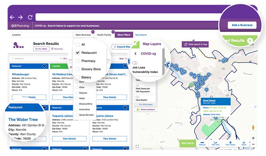
GIS Planning has launched an online tool that enables local businesses across North America to communicate with customers for free in real time.

ZoomBusiness, created in response to the COVID-19 pandemic, is an interactive, mobile-responsive mapping directory for communities that ensures customers can find open restaurants, stores and services in their region at no charge.

Businesses can list themselves for free on their local ZoomBusiness site, hosted by economic development organizations like cities, towns, counties or chambers of commerce. The businesses can provide customized details including websites, modified hours, delivery or curbside pickup options, promotions and gift card stimulus programs.

Residents can search for area businesses by categories, including grocery stores, pharmacies, banks, health facilities, hardware stores, pet stores and automotive shops, among others.

North America deployment

Local ZoomBusiness sites have already been deployed in more than 20 communities across North America during its soft launch, including regions of eastern Pennsylvania;, the City of Columbia, South Carolina; the state of Wyoming (which has listed more than 600 businesses on the directory); and Abbotsford, British Columbia.

“We created ZoomBusiness after realizing that small businesses need new, accurate ways to communicate that they are still open to their customers, given that social distancing requirements, product availability and operating hours are changing by the day,” said Pablo Monzon, managing director and co-founder, GIS Planning. “Our development team has created an intuitive tool to index and map business information across North America in real-time, and we believe it will be an enormous resource for the communities we serve.”

ZoomBusiness is a simple-to-use data tool, powered by Google Maps, using various layers for precise queries. Businesses are prompted to directly enter information on their current status and the content is verified by the organization hosting the GIS tool.

GIS Planning also added free map layers, including a COVID-19 case map updated daily by the New York Times, and a job-loss vulnerability index using recent employment data from Chmura.
Screenshot: GIS Planning

Screenshot: GIS Planning

Columbia, South Carolina

The city of Columbia features 180 businesses on ZoomBusiness, helping residents discover delivery and curbside food options. That number is expected to quickly rise to more than 300 as business owners input data. Columbia will continue to promote safe and responsible “Shop Local” practices, Coleman added, in hopes that residents will take advantage of the service and support local businesses.

“Through our work with GIS Planning, we’ve been able to take our list of open restaurants and businesses and integrate it into the available properties map on our website,” said Ryan Coleman, director of the City of Columbia Office of Economic Development. “During this crisis, local businesses need every advantage we can give them, and this is another tool in their arsenal in helping to mitigate the negative impact of COVID-19.”

Abbotsford, British Columbia

The new solution has also made an impact in Canada, including the City of Abbotsford, British Columbia, which is promoting 130 businesses ranging from grocers to auto shops and medical suppliers.

“This is a resource that fills an urgent need. The long-term health and security of our businesses depend, in part, on the decisions we’re making right now,” said Kim O’Sullivan, City of Abbotsford’s economic development coordinator. “ZoomBusiness allows owners to communicate directly with their customers, many of whom would frequent these businesses, even online, if they knew they were able to do so.”

ZoomBusiness clients are given a unique link to their region which is then shared across organizational websites and social media to reach residents.

“Main Street businesses are truly the lifeblood of a community,” said Alissa Sklar, vice president of marketing for GIS Planning. “According to FEMA, up to 40% of small businesses never reopen after a major disaster. With ZoomBusiness, we want to help make sure the local restaurants, retailers and service providers that define local communities are still there to serve area residents when this pandemic is over.”

GIS Planning has made its ZoomBusiness tool free for its existing economic development clients (those using its investment attraction map, ZoomProspector); it is also available to new clients for a nominal fee. Prices are indexed to population size to keep them affordable for all communities. New clients can also be set up and ready to launch the tool within one day.

Following the COVID-19 recovery, data experts at GIS Planning forecast continued use of the directory to promote small and medium-sized businesses across North America.

Publicerad den Lämna en kommentar

Esri User Conference goes virtual because of COVID-19

The Esri User Conference, which usually takes place in San Diego in July, will this year be held virtually.

“As a result of the coronavirus disease 2019 (COVID-19) crisis, we are making the decision to move the 2020 Esri User Conference in San Diego to a virtual format. This is a great disappointment to me personally, as I know it will be for many of you,” Esri CEO Jack Dangermond told those planning to attend in an April 22 e-mail.

The following is an outline of our current plan, with more information available in the Esri UC FAQs:

  • The event will take place July 13–15, 2020.
  • The Plenary Session, technical workshops and Esri Showcase will be virtual, featuring many demonstrations and live discussions during the conference.
  • There will be many opportunities for networking, collaboration and real-time interaction with Esri experts and staff.
  • User presentations and the Map Gallery will be featured digitally.
  • A library of recorded sessions and demos will be created and kept available as an ongoing resource.
  • Registration will be complimentary for all Esri customers who are current on their maintenance or subscription.

Dangermond also asked for ideas and suggestions solicited through a survey by April 29.

“Forty years ago this month, we had our first User Conference in Redlands, California, with only a handful of participants,” Dangermond wrote. “While initially no one was quite sure of what the outcome would be, the event started an ongoing tradition where Esri and our users would come together, share our work, learn and create a community of common interests.

“That first meeting on the Esri campus provided the groundwork for the annual event at which thousands of professionals from every corner of the globe meet one another, share inspiring examples of work and learn from each other’s experiences.

“While we can’t replicate the experience of being together in person, we will do our best to create an amazing event that will continue to move you and our community forward. One of the benefits of going with a virtual format will be that organizations will be able to send an unlimited number of attendees.”

Photo: GPS World Staff

Photo: GPS World Staff

Publicerad den Lämna en kommentar

Kolmostar’s instant cold-boot GNSS module ready to sample

Photo: Kolmostar

Photo: Kolmostar

Kolmostar’s ultra-low power, instant cold boot GNSS module JEDI-200 and its evaluation kit (EVK) are now fully released and available for purchase.

The JEDI-200 was recognized by IoT World — one of the largest internet of things (IoT) conferences — as one of the most innovative consumer internet of things (IoT) solutions earlier this year.

JEDI-200 specification highlights include:

  • Low energy consumption of 25 mJ/position fix
  • Short cold-boot TTFF of 1 second
  • 5.0 meter CEP positioning accuracy
  • Supports GPS and BeiDou constellations
  • 50 Byte/12-hour compressed ephemeris (EPH) for speedy download, enabling A-GPS via LPWAN while significantly reducing EPH download power consumption overhead
  • High-performance cloud computing for minimum end device power consumption and seamless integration with customers’ backend data analytics platforms and dashboard applications
  • Integrated SAW filter, stand-alone LNA and TCXO
  • 12mm x 16mm industry-proven standard form factor for easy wireless connectivity integration

Specially designed for IoT applications such as pet and personal object tracking, livestock tracking, fixed and nomadic logistics, infrastructure tracking and shared economy, JEDI-200’s reduced level of power consumption and optimized efficiency with LPWAN solve IoT endpoint deployment’s pain-point of needing frequent recharges or a large battery.

“Kolmostar’s JEDI-200 is a breakthrough in the IoT asset and personnel tracking application domain,” said Lucy Fan, VP of marketing and sales at Kolmostar. “JEDI-200 is well suited for battery-powered IoT applications which have stringent requirements on product size, weight, response time, battery life and GPS reporting frequency.”

Worldwide customers have started developing based on JEDI-200, and field deployments are expected in the second half of 2020.

“We have seen unparalleled advantages of the JEDI-200, enabling unique features and use cases which cannot be achieved before with traditional GNSS solutions,” Fan said. “With the latest developments in cellular and non-cellular low-power wide-area network (LPWAN) technologies, such as NB-IoT, LTE-M, LoRaWAN and Sigfox, JEDI-200 is well positioned to enable more rapid deployment of IoT asset tracking use cases for our customers worldwide.”

Publicerad den Lämna en kommentar

GPS and PNT experts react to Ligado decision

Leaders in the GNSS/PNT community are reacting to the Federal Communications Commission (FCC) decision to approve an order to allow Ligado Networks to deploy a low-power nationwide 5G network. The departments of Defense and Transportation have criticized the decision, concerned about interference with GPS signals.

Below are statements we have received from our readers.


Logan Scott

Photo: Logan Scott

Logan Scott

Spectrum regulation is much like land use zoning in that certain services are kept separate so as to avoid disturbing the neighbors. The FCC has in effect allowed Ligado to build an outdoor concert venue next to a monastery and by way of compensation, they offer free earplugs. GPS / GNSS signals are extremely weak and the receivers are extremely sensitive. To give some perspective, by the time they get to the GPS receiver, GPS signals are about a factor of 20 less powerful than cosmic background noise. Ligado’s spectrum is/was licensed for mobile satellite services (MSS) and so was not likely to interfere with GPS.

With their new, and much more valuable license, Ligado now has a legal right to build a terrestrial cellular service. Exhaustive testing over the last 10 years has repeatedly demonstrated that such a system will interfere with high precision GPS/GNSS receivers used in surveying, timing, and earth observation. The DoD has also made strong claims that such a system will cause harm to their systems. In all cases, the effect is much like riding a bicycle at night. You can see fine until someone comes around the corner with the high beams on and blinds you.

The FCC has in effect allowed Ligado to build an outdoor concert venue next to a monastery and by way of compensation, they offer free earplugs.

In their earlier filings, Ligado had asked for permission to transmit at a power level of 1500 Watts. In an amazing piece of legerdemain, they convinced the FCC, but not the DoT or DoD, that by reducing transmit powers to 10 Watts, there would be no harm. This is a stunningly erroneous claim. As you lower the transmit power, you need many more cellular basestations to cover a given area. To use an analogy from my backyard, I can install one high flow sprinkler head to cover the entire yard or a bunch of low flow heads, each covering a small portion. Either way, the grass doesn’t care about anything other than inches of water and I’m gonna get wet if I run across the yard. Ligado’s core argument is equally wet. Nonetheless, it has great appeal to people who don’t understand how cellular systems work.

So, moving forward and assuming the license stands, interference events will become more prevalent and GPS will be deemed “less reliable”. Because interference sources are largely untraceable, blame will rarely attach to Ligado.  I expect that GNSS receiver vendors will incorporate improved filters into receivers and pass the cost along to buyers. Ligado, or more likely whoever they sell the spectrum to, will quickly move to petition for increase transmit powers so as to lower capital costs; after all more basestations cost more. And so, the Visogoths have arrived, 4G in hand with a 5G label.


Mitch Narins

Mitch Narins

Mitch Narins

It is quite concerning when a panel of lawyers make a decision, despite the results of years and years of studies, over the objections of our nation’s technical and operational experts. While I have championed the need for a complementary and resilient PNT system for many, many years, one cannot dispute the worldwide benefits that GPS and other GNSS have brought — from safety, security, and economic perspective.

As noted in the FCC’s press release, “The order also requires Ligado to protect adjacent band incumbents by reporting its base station locations and technical operating parameters to potentially affected government and industry stakeholders prior to commencing operations, continuously monitoring the transmit power of its base station sites, and complying with procedures and actions for responding to credible reports of interference, including rapid shutdown of operations where warranted.” I believe that it is imperative that GPS users, both within the government and in the private sector, understand:

  1. How base station location information will be disseminated, what power levels and radiation patterns will be utilized, and what recourse GPS users will have to object to the proposed location and service;
  2. How the service will be monitored for each base station location, what systems will be used to do the monitoring, and how the monitoring information will be publicly disseminated;
  3. How reports of interference will be filed, how and by whom they will be determined to be “credible,” how and in what timeframe will a “rapid shutdown of operations” be accomplished, and how appropriate mitigations will be identified and implemented.
  4. Given the importance and concern associated with this action, what special oversight mechanisms, involving civilian and military participants, should be put in place to avert potential safety, security, and economic impacts to our nation’s critical infrastructure.

Finally, regardless of whether one agrees or disagrees with the FCC’s order, no one can possibly believe that what has transpired over the last decade is an example of good practice. I hope that somehow a leadership body takes up the task to do an independent lessons learned — we should never have to go through this ever again.

Additional thoughts: In addition to the thoughts I provided previously, I began thinking about one of the PNT cases that concerned aviation in regards to the proposed Ligado service — first responder/medevac helicopters.

While one can model, and even test problems based on the location of facilities where aircraft would be expected to be operating close to the ground, e.g., airports and heliports, one can never be sure where a medevac or other first-responder helicopter may have to set down responding to an accident or incident site. In keeping with the FCC’s own press release, it is unclear how a pilot experiencing problems with GPS (if, in fact, the pilot could recognize the problem) would be able to report the issue and have it mitigated in real time to support a safety or security mission — unless all areas around the ground transmitter were mapped and first responders could request specific ones to be turned off when operations were expected in a know area. Unfortunately, the limits of these operating areas is many times unknown or changing (e..g., forest fires).

It made me think about a demo that a Mitre friend did regarding sUAS and their ability to detect and avoid an aircraft based on receipt of its ADS-B squits. Perhaps these ground transmitters should include ADS-B receivers and automatically go off-air if a helicopter came within a certain distance. I have no doubt that Ligado would not appreciate this idea.

Mitch Narins is the principal consultant and owner of Strategic Synergies, LLC, a technical and management consulting firm that he formed after retiring following over four decades of U.S. government service with the FCC and the Federal Aviation Administration.


Publicerad den Lämna en kommentar

Hemisphere GNSS presents Phantom, Vega GNSS OEM boards at Intergeo 2019

About the Author:

Allison Barwacz is the digital media manager for North Coast Media (NCM). She completed her undergraduate degree at Ohio University where she received a Bachelor of Science in magazine journalism from the E.W. Scripps School of Journalism. She works across a number of digital platforms, which include creating e-newsletters, writing articles and posting across social media sites. She also creates content for NCM’s Pit & Quarry magazine, Portable Plants magazine and Geospatial Solutions. Her understanding of the ever-changing digital media world allows her to quickly grasp what a target audience desires and create content that is appealing and relevant for any client across any platform.

Publicerad den Lämna en kommentar

How is COVID-19 affecting you? Take part in our survey

GPS World is conducting a short survey to shed light on the impact of COVID-19 on the GNSS/PNT industry.

The short survey covers topics such as

  • changes in daily work habits
  • communication methods with staff, technology partners and clients
  • how each core sector is responding to the coronavirus pandemic
  • how we are all trying to remain productive despite social-distancing directives.

GPS World is committed to providing the most up-to-date coronavirus resources for the GNSS/PNT industry. We value your thoughts and opinions and would love to include your thoughts on the subject through our survey.

Results of the survey will be shared in the June issue of GPS World magazine.

With impacts related to the coronavirus developing on a daily basis, GPS World may reach out again in the near future to hear how you’re doing. As always, thank you for your continued support.

Take the short survey here.


Photo: MyImages_Micha/iStock / Getty Images Plus/Getty Images

Photo: MyImages_Micha/iStock / Getty Images Plus/Getty Images