Publicerad den Lämna en kommentar

Nearmap acquires Pushpin tech for roof geometry

Figure 2: Rapid growth requires frequent imagery. Above is a new Durham neighborhood under construction. (Photo: Nearmap)

Photo: Nearmap

Aerial imagery company Nearmap has acquired technology and assets from Pushpin, a deep learning and analytics technology company that extracts data from 3D models to provide roof geometry insights to a variety of sectors including roofing, solar and government.

The technology acquisition allows Nearmap to rapidly extract and disseminate roof geometry from its wide-scale 3D models and offer a new form of location content to its customers.

‘‘By acquiring Pushpin’s 3D geometry extraction technology and pairing it with our rich data, we bring the best of both worlds together at unprecedented scale’’ said Rob Newman, Nearmap CEO. “Over the past couple of years, we’ve evolved our offering from 2D imagery to a multi-product portfolio, and this acquisition is an important milestone in our approach to continue adding new content types for our customers. This addition aides our company mission by providing 3D geometry data at unmatched speed, thereby changing the way our customers perform their work.”

With this new technology, Nearmap can provide a semi-automated calculation and extracted representation of any roof geometry within an hour, significantly reducing turnaround time. The combination of Nearmap’s 3D content and Pushpin’s geometry extraction technology opens up a diverse range of use cases, enabling businesses to fast-track job estimation, determine solar irradiance, plan drone delivery routes and model 5G propagation.

“The addition of Pushpin’s 3D geometry extraction technology into our large-scale 3D reality models will enable us to further evolve our offering and produce at scale roofing geometry,” said Tom Celinski, Executive Vice President, Technology and Engineering at Nearmap. “With the added ability to provide roof geometry data, we will be able to provide even deeper insights on what’s happening on the ground, and help businesses and government organizations transform the way they work and do their job more efficiently.”

The roofing and solar industries are poised for significant growth. Currently, 1% of the United States population has solar panels on their homes. According to the Solar Energy Industry Association (SEIA), total U.S. solar capacity will more than double over the next 5 years.

Additionally, a significant number of U.S. residential homes have their roofs replaced every year due to roof damaging storms and changes in roofing trends and material. This new product offering from Nearmap is poised to significantly impact these markets, as companies are expanding their use of technology to assist with tasks such as roof material and project quoting through reports, project management through roofing specific software, and customized sales and marketing tools for the roofing industry.

Publicerad den Lämna en kommentar

Highway scanning/GNSS system moves foward in Germany

Germany’s Federal Highway Research Institute (BASt) is using a specialized semi-truck to analyze and map road surfaces. The research vehicle uses GNSS, scanner and camera equipment to record the condition of road surfaces and the substance of the asphalt surface, providing the basis for optimum maintenance planning.

The truck is part of the BASt’s MESAS program, which began in 2018. The unique measuring vehicle is a multi-functional assessment tool for fast-moving substance detection, such as for structural evaluation and design of pavements.

For the MESAS program, innovative measurement technology was installed on a single-axle semi-trailer, with all measurement systems synchronized and georeferenced using a GNSS system.

The MESAS measuring vehicle is 14.5 meters long and weighs 22 tons. At speeds of up to 80 km/h, MESAS records road condition parameters with high precision. (Photo: BASt)

The MESAS measuring vehicle is 14.5 meters long and weighs 22 tons. At speeds of up to 80 km/h, MESAS records road condition parameters with high precision. (Photo: BASt)

The vehicle includes:

  • the Pavement Profile Scanner PPS-Plus from Fraunhofer IPM
  • a laser-based Traffic Speed Deflectometer (TSD) that measures short-term reversible deformations of the road surface
  • a georadar that detects layer thicknesses and inhomogeneity of the road superstructure
  • ambient cameras that provide images for interpreting the georadar measurements

During test runs, the vehicle system successfully measured more than 11,000 kilometers of the country’s trunk-road network. Now it begins regular operation.

“MESAS is a globally innovative measuring system,” said Dirk Jansen, department head, BASt. “Here we have a really powerful tool at our disposal with which we can make an innovative and significant contribution to the further development of conservation planning.”

Laser-based measuring systems record the road surface without contact. The measurement data are synchronized and georeferenced with the help of a GNSS system. Software tailored to the application manages the data and supports route planning and quality assurance during operation. (Diagram: Greenwood Engineering A/S All Rights Reserved (modified).)

Laser-based measuring systems record the road surface without contact. The measurement data are synchronized and georeferenced with the help of a GNSS system. Software tailored to the application manages the data and supports route planning and quality assurance during operation. (Diagram: Greenwood Engineering A/S All Rights Reserved (modified).)

Millimeter precision. The Pavement Profile Scanner PPS-Plus records the transverse evenness of the road surface with high precision. The scanner, the size of a shoe box, is mounted on measuring vehicles and scans the road surface with an eye-safe laser beam over a width of about 4 meters. The distance to the road surface is determined with sub-millimeter accuracy using phase-shift technology.

The laser scans the surface with the aid of a rotating polygon mirror perpendicular to the forward movement of the vehicle and generates 800 profiles per second. Each profile consists of up to 900 measuring points, depending on the selected measuring frequency. In this way, the PPS generates a detailed 3D height profile of the road surface.

At traveling speeds of 80 km/h, the measuring point distance in the longitudinal direction is approximately 28 millimeters; in the transverse direction it is 4.5 millimeters. It also provides photorealistic grey-scale images of the road surface that show millimeter-thin structures, such as small repairs and patches.

Publicerad den Lämna en kommentar

Trimble provides precision controller and display to farmers

Trimble has introduced the GFX-350 display and NAV-500 guidance controller, providing a cost-effective option for farmers seeking to adopt the latest precision agriculture technology for their daily operations.

The GFX-500 display. (Photo: Trimble)

The GFX-500 display. (Photo: Trimble)

The GFX-350 Android-based touchscreen is a cost-effective way to introduce auto-steering and application control to the farm. The 7-inch (18-centimeter) screen is easy to read and can be used to control most field operations with a few taps.

The display is compatible with both the NAV-500 and the NAV-900 guidance controllers, satisfying different user accuracy needs. The simple and intuitive Precision-IQ operating system speeds up field work and makes equipment configuration a breeze. Once vehicles, fields, implements and materials are set up during the first use, they are saved and can be re-used with a couple of clicks.

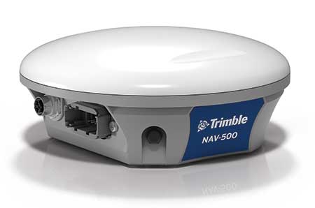
The NAV-500 controller. (Photo: Trimble)

The NAV-500 controller. (Photo: Trimble)

In addition, the GFX-350 display is fully ISOBUS compatible, offering plug-and-play capability for ISO-enabled implements with native task controller and universal terminal functionality. The display also features onboard Wi-Fi and Bluetooth connectivity, allowing seamless sharing of data between the office and the field via optional Trimble Connected Farm solutions. General record keeping and proof of placement reporting has never been easier.

The NAV-500 guidance controller features a low-profile rugged housing capable of receiving signals from five different GNSS satellite constellations — GPS, Galileo, GLONASS, BeiDou and QZSS. This precision solution offers sub-meter repeatable accuracy and full-farm coverage ideal for tillage, broad-acre seeding, spraying and harvest operations.

By using Trimble’s ViewPoint RTX satellite-delivered correction service with the NAV-500, operators can consistently achieve 15 centimeter pass-to-pass accuracy. Paired with either the new GFX-350 display or larger 10-inch (25.4-centimeter) GFX-750 display, the NAV-500 can provide roll-corrected manual guidance or can automatically control steering with the EZ-Steer assisted steering system and EZ-Pilot® Pro steering system.

“Connectivity and interoperability are very important to the future of agriculture and Trimble has made these features a cornerstone of our product portfolio,” said Abe Hughes, general manager of Trimble’s Agriculture Division. “Customers can select from a range of hardware and software options to meet their specific needs and budget. And the true beauty of this flexible product integration is that it can grow with the farmer’s operation. Upgrades can be as simple as moving to a higher precision correction signal or using existing mounts to install a larger and more capable receiver or display. Ease of installation and operation are key with the GFX-350, which can reduce barriers to entry for farmers new to precision agriculture.”

The GFX-350 display and NAV-500 guidance controller are designed for clean and simple installation that can typically be completed in half a day, getting farming equipment back in the field faster. The display uses a quick release RAM mount for easy transfer between vehicles, and typically requires only two cables to be attached, reducing clutter in the cab.

Trimble’s GFX-350 display and NAV-500 guidance controller are expected to be available for order in the fourth quarter 2019 from the Trimble dealer and Vantage distribution networks.

Publicerad den Lämna en kommentar

Collins Aerospace joins GPS Innovation Alliance

GPS Innovation AllianceCollins Aerospace has joined the GPS Innovation Alliance (GPSIA).

Collins Aerospace is one of the world’s largest suppliers of aerospace and defense products, and joins founding-member companies John Deere, Garmin and Trimble as well as 11 national organizations who make up GPSIA’s affiliates program.

Collins will further bolster the Alliance’s goal of enhancing GPS innovation, creativity and entrepreneurship.

“We are excited to welcome Collins Aerospace as the newest member of the GPS Innovation Alliance,” said GPSIA Executive Director J. David Grossman. “As one of the leading aerospace companies in the world, Collins has a long and deep history with GPS technology, beginning with the first GPS signal ever received from the roof of their facilities in Cedar Rapids, Iowa. We look forward to working with Collins Aerospace as the newest member of GPSIA and are confident that they will be a valuable addition in our efforts to heighten awareness of the economic importance and societal benefits of GPS.”

“GPS technology is vital to Collins Aerospace, enabling us to achieve innovative solutions for the aerospace and defense industries,” said Frank Zane, associate director of Business Development, Position, Navigation, Timing (PNT), Collins Aerospace. “We are thrilled to join the GPS Innovation Alliance in their long-standing efforts to ensure the continuous availability, accuracy, reliability, and resiliency of the GPS constellation.”

​The GPS Innovation Alliance was founded by Deere & Company, Garmin International, Inc. and Trimble Inc. The alliance recognizes the ever-increasing importance of  GPS  and other GNSS technologies to the global economy and infrastructure and is firmly committed to furthering GPS innovation, creativity and entrepreneurship.

Publicerad den Lämna en kommentar

Russia successfully launches Glonass-M satellite

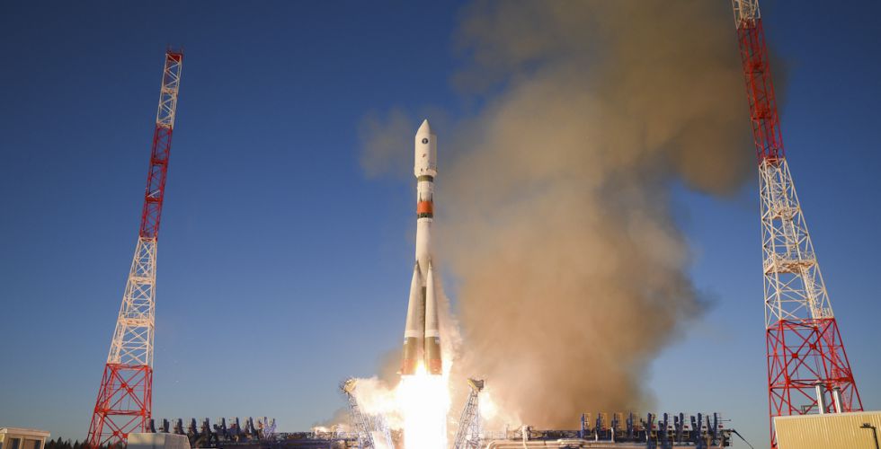
A new Glonass-M navigation satellite is now aloft, preparing to join Russia’s GLONASS constellation.

The satellite launched Dec. 11 at 11:54 Moscow time aboard a Soyuz-2.1b launch vehicle from the Plesetsk cosmodrome, the Russian Ministry of Defense’s Information and Communications Department said.

The launch was initially scheduled for December 10, but was postponed for a day for technical reasons.

Glonass-M satellites form the basis of the orbital constellation of the GLONASS system. They provide navigation information and accurate time signals to land, sea, air and space consumers.

The Ministry of Defense noted that pre-launch operations and the launch of the rocket were normal. “Means of the ground-based automated spacecraft control complex of the Russian orbital group controlled the launch and flight of the rocket,” the military department said.

The Fregat booster unit was manufactured by NPO Lavochkin (part of Roscosmos State Corporation.) The Glonass-M navigation satellite was produced by ISS and is named after academician M.F. Reshetnyova.

Publicerad den Lämna en kommentar

J-Shield filters out interference

The Triumph-LS receiver. (Photo: JAVAD GNSS)

The Triumph-LS receiver. (Photo: JAVAD GNSS)

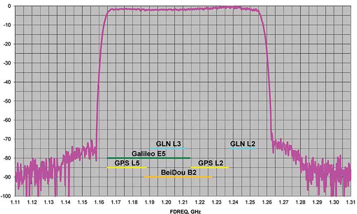
J-Shield is a robust filter on JAVAD GNSS antennas that blocks out-of-band interference (Figure 1). In particular, J-Shield blocks signals that are near the GNSS bands, including the proposed Ligado Networks (formerly LightSquared) broadband signals, explained Javad Ashjaee, founder and CEO of Javad GNSS.

FIGURE 1. Protection characteristics: The J-Shield filters have a sharp 10-dB/KHz skirt, which provides up to 100-dB of protection. (Image: JAVAD GNSS)

FIGURE 1. Protection characteristics: The J-Shield filters have a sharp 10-dB/KHz skirt, which provides up to 100-dB of protection. (Image: JAVAD GNSS)

The anti-jam digital filters protect against in-band interference such as the harmonics of nearby TV and radio stations, or against illegitimate in-band transmissions. The anti-jam filters can be combined in pairs for complex signal processing and can simultaneously suppress several interference signals.

“The filters make the near band spectrums available for other uses,” Ashjaee said. “They protect GNSS bands now and in the future.”

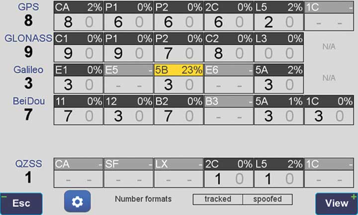
In-Band Noise Measurement. The receiver measures the level of interference as a percentage of noise above the normal condition. Figure 2 shows the condition in a clean environment, where eight GPS satellites were visible, according to the almanac. In all, eight C/A, six P1, six P2, six L2C and two L5 GPS signals were tracked. The noise level was 2% on C/A and L5 and 0% on P1, P2, and L2C.

FIGURE 2. Clean environment. (Image: JAVAD GNSS)

FIGURE 2. Clean environment. (Image: JAVAD GNSS)

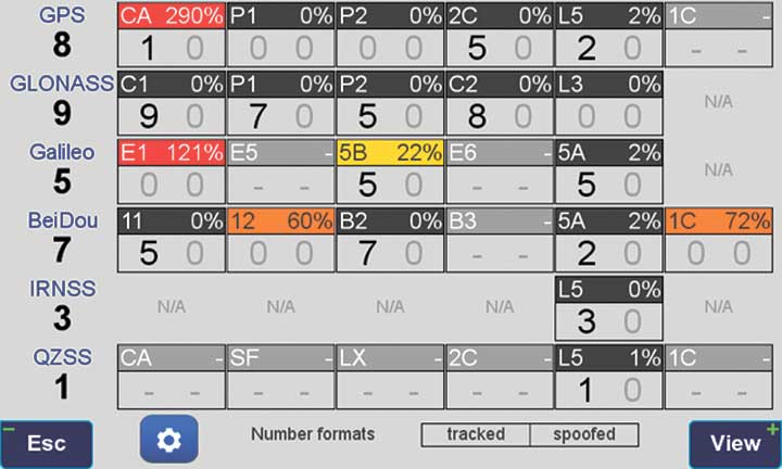
Figure 3 shows 290% noise in the GPS C/A signal and 121% noise in Galileo E1. Only one of the eight GPS C/A code and none of five Galileo E1 signals could be tracked because of the high level of interference.

FIGURE 3. High interference levels. (Image: JAVAD GNSS)

FIGURE 3. High interference levels. (Image: JAVAD GNSS)

Spectrum Analyzer

Filters in the GNSS antenna provide one way to protect GNSS signals from interference. Another is the receiver chip itself. For instance, the Javad GNSS Triumph chip includes an integrated spectrum analyzer — a more efficient solution than using a commercial spectrum analyzer to continuously monitor and evaluate the environment, Ashjaee explained.

The spectrum analyzer monitors the spectrum inside the chip. It has an effective bandwidth of 1 KHz, and can be programmed to automatically record the spectrum (and other information) periodically or according to pre-set conditions. Each spectrum shows the power and shape of any interfering signals and jammers.

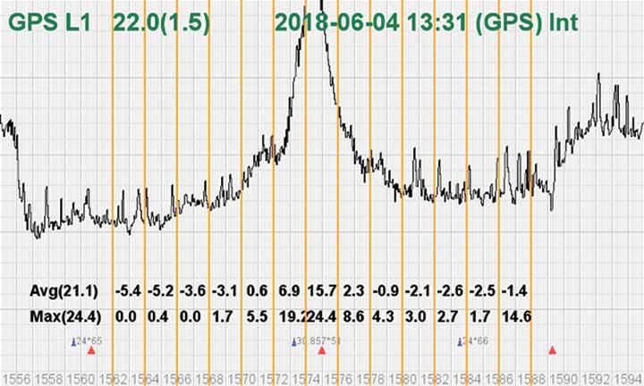
Figure 4 shows the shape of the GPS L1 band spectrum when the band is jammed, as indicated by the huge peak in the center where the C/A code is. The number on the bottom left is the height of the peak. The height of the spectrum is 21.1 dB; compared to a calm spectrum of 11.2 dB, this spectrum indicates a jamming impact of about 10 dB.

FIGURE 4. The L1 band is jammed, as shown by the peak.

FIGURE 4. The L1 band is jammed, as shown by the peak. (Image: JAVAD GNSS)

Automatic Gain Control. In addition to monitoring the spectrum, the Triumph chip also keeps a record of automatic gain control (AGC) — another indicator of unwanted external signals. The AGC monitors the environment and adjusts the gain to keep the voltage at a certain level. The change in AGC is an indicator of interference.

Spoofers

“Spoofers are quite different from jammers,” Ashjaee said. “They don’t disturb the environment and the spectrum shape. They broadcast a GNSS-like signal to fool the GNSS receivers to calculate wrong positions. We detect spoofers by digital signal processing.”

With 864 channels and about 130,000 fast-acquisition channels in the Triumph 2 chip, it has the resources to assign more than one channel to each satellite to find all of the signals transmitted with the same GNSS PRN code — including spoofed signals.
“If we detect more than one reasonable and consistent correlation peak for any PRN code, we know that we are being spoofed and can identify the spoofer signals,” Ashjaee said. The chip isolates and ignores the wrong peak.

“Usually more than 100 signals are available at any given time. We need only four good signals to compute position,” Ashjaee said. “We reject infected signals, and then among all the available GPS, GLONASS, Galileo, BeiDou, IRNSS and QZSS signals, we use the healthy ones. It is extremely unlikely that we can be spoofed without our knowledge. We can immediately recognize spoofing and take corrective actions. In the rare case that all signals are affected, we inform the user and guide them to use a compass and altimeter to get out of the jammed area.”

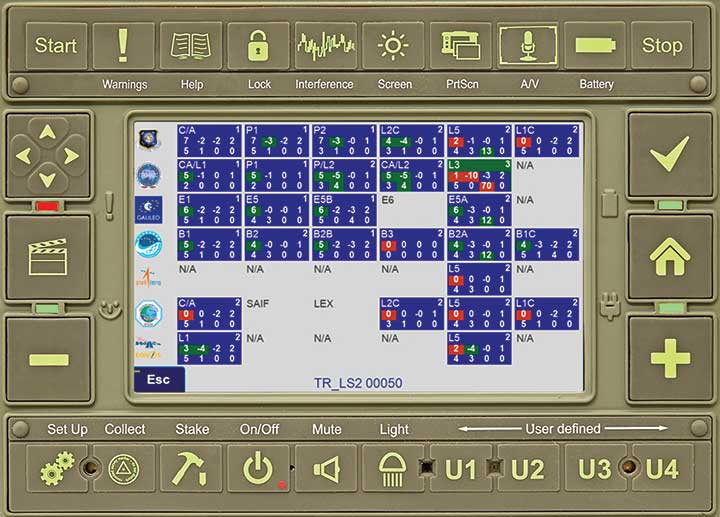
Figure 5 is a screenshot from the company’s Triumph-LS survey receiver, showing the details of each signal tracked. The first six lines in this screenshot show the spoofed signals that were detected as soon as they appeared (number “1” in the C1 column). Percentages show the amount of interference above the normal level.

In the last column, T indicates the signal was tracked by the main channels, Q by the fast-acquisition channels, and U indicates the signal was used in position calculations.

Figure 5. Signal Details: The Triumph-LS receiver provides users with a wealth of information on each signal received, including spoofed signals.

Figure 5. Signal Details: The Triumph-LS receiver provides users with a wealth of information on each signal received, including spoofed signals.

Indicators for Healthy Signals

In addition to the spectrum shape and AGC, these other indicators show the health of GNSS signals:

  • Number of signals tracked.
  • Divergence of SNR from its expected value.
  • Level of additional power and its RMS.
  • Divergence of AGC from its normal value and its RMS.
  • Extra noise.
  • Number of signals spoofed.

As an aid to users, the company’s Triumph-LS receiver can display the status of all GNSS signals received. Figure 6 shows this compact view, with normalized values of the above indicators (0 means good and 9 means poor).

Figure 6. Signal Status. Information on all GNSS signals received as shown by the Triumph-LS. (Image: JAVAD GNSS)

Figure 6. Signal Status. Information on all GNSS signals received as shown by the Triumph-LS. (Image: JAVAD GNSS)

Users of the Triumph-LS can click on any of the signal buttons to see the actual and normalized values of the indicators for that signal. Action buttons provide quick access to View Satellites, View Spoofing, View Spectrum and Take Spectrum. Jamming and spoofing protection is an option on all Javad GNSS products and OEM boards.


See also:

Access denied: Anti-jam technology mitigates navigation warfare threats, By Matteo Luccio
New CRPA concept antenna designed, By Tony Murfin

Publicerad den Lämna en kommentar

Access denied: Anti-jam technology mitigates navigation warfare threats

GPS signals are by far the single most widely used and most accurate source of navigation, positioning and timing (PNT), and this capability is deeply integrated into every aspect of our society. In particular, the timing service provided by GPS, while virtually unknown to the general public, is essential for a variety of digital operations — from performing financial transactions to operating cell phone networks to running the internet.

Of course, GPS — originally developed to guide nuclear submarines — is now vital to most military missions, and the system’s vulnerabilities are a source of great concern.

GPS has been remarkably reliable over the past quarter century. Solar flares are rare, multipath can be largely mitigated, and obstructed line-of-sight to the satellites is an acute problem only in certain environments, such as urban canyons.

The most serious intentional threats to GPS are spoofing and jamming. Jamming is more widespread — it is more easily accomplished intentionally and it also occurs unintentionally. In the defense sphere, intentional jamming is a regular occurrence. It is expected as a routine aspect of electronic warfare operations to disrupt and deceive, typically just before the shooting begins. Unintentional jamming includes recently re-emerging concern about potential interference by ultra-wideband devices.

Experts at NovAtel, Collins Aerospace, L3Harris Technologies and Honeywell address the challenges posed by jamming and the relative effectiveness of various anti-jamming approaches.


NovAtel

Tackling Jamming on Multiple Levels

GPS World cover December 2019Disruption by jamming of GPS’s PNT data “is occurring with a growing regularity,” said Dean Kemp, Defense Segment manager at NovAtel, part of Hexagon’s Positioning Intelligence division. The problem will only increase, given our reliance on GNSS and increasing demand for precision. In the military sphere, electronic warfare in Syria, as well as jamming in Ukraine, Korea, and Finland, “have shown that modern, high-power equipment is routinely being used to disrupt the military.”

In the civilian sphere, interference is a growing issue because of cheap and effective jammers available via the internet. People use these so-called personal privacy devices to defeat vehicle tracking devices for purposes ranging from avoiding supervision all the way to hijacking vehicles.

GNSS signals are vulnerable because the received power is so small that receivers can be disabled with an incident power in the picowatt (10-12 W) range. “Jammers come in many different forms,” Kemp said, “from low-power civil devices to complex and powerful military-grade electronic warfare systems that can disable civilian receivers from a few hundred meters to hundreds of kilometers.”

Situational Awareness. Users can fail to recognize that their GPS is being jammed, Kemp said. Beyond defending against possible jamming scenarios, it is also necessary to “identify, find, and characterize the source of interference and to provide this information to the user so that it can be used appropriately.” In the defense field, this is known as situational awareness.

Emerging jamming threats, Kemp explained, can be understood within the context of cyber and information warfare using the Cyber Electromagnetic Activities (CEMA) layered approach. It recognizes a cognitive layer — a human decision based on PNT data; a virtual layer, in which PNT data are used to inform or support networked systems; and a physical layer, the hardware used to provide and protect PNT data.

Therefore, effective anti-jamming requires that:

  • users understand the system’s vulnerabilities and identify when they are being jammed, so that they can resort to traditional means for positioning and navigation (but not timing)
  • PNT data be protected and verified before being trusted
  • on the physical level, there be a multi-layered and heterogeneous approach that provides assured PNT information in the presence of jamming and spoofing without quantifiable loss of accuracy.

By combining these considerations at each layer, “they form a unified view on capability,” Kemp said.

Spoofing with Pokémon. Jamming threats are evolving, employed by both civilian and state actors. Worse, these threats are augmented by spoofing. While spoofing is harder to achieve than jamming, it is potentially more concerning. “Spoofing the receiver by rebroadcasting the GNSS signals or by generating them from a simulator has become a regular occurrence,” Kemp said.

Spoofing came to public attention in 2016 when enterprising programmers designed location-deception apps to hack the Pokémon Go mobile game. Instances have since been reported worldwide. Because early spoofing demonstrations were conducted against simple GPS L1 C/A-code receivers, it was initially hoped that spoofing could be defeated by using dual- or multi-frequency receivers.

However, it has been demonstrated that multi-frequency receivers using commercially available components can also be spoofed, “at least when the receiver is using multiple frequencies of GPS,” Kemp noted. “Adding further GNSS signals will help, but the best defensive measure is to employ, if authorized, an encrypted military signal.”

Coverage Improvement Factor. Typically, the effectiveness of an anti-jam system is assessed on the basis of the jamming to signal ratio (J/S) figure in decibels, which depends on variables such as the receiver’s front-end RF bandwidth, the signal type being tracked (C/A versus P(Y) code), the signal tracking threshold of the receiver, the receiver platform dynamics, the choice of receiver oscillator, the interference type and antenna characteristics.

Difference in how manufacturers calculate J/S led to the invention of the coverage improvement factor (CIF), adopted by the GPS Joint Project Office. “CIF gives a single number that describes the effectiveness of an anti-jam system for a particular jammer scenario, given that space vehicle positions vary by elevation and azimuth,” Kemp said.

However, the use of CIF to assess the anti-jam performance is a highly technical process and the results are usually classified. He discussed current approaches to anti-jamming.

  • Multi-element, controlled reception pattern antennas (CRPA), which pass the good signal to the receiver while nulling out the interference, are the first line of defense. “The system can dynamically change the gain pattern of the antenna so that as the platform and jammers move, the gain pattern adapts so that nulling continues effectively.”
  • The use of multiple constellations and frequencies can be an effective tactic to mitigate interference, “but relies on the jammer not covering the bands of interest.”
  • “Obtaining actionable data on interference is almost as important as mitigation,” because it enables users to modify plans. However, “interference effects can be difficult to diagnose and complicated to track down.”
  • Monitoring automatic gain control can indicate jamming.
  • “Coupling a GNSS receiver with a robust inertial measurement unit (IMU) will provide a higher level of protection for GNSS signals due to the IMU providing reliable position, velocity and attitude even through short periods when satellite signals are blocked or unavailable.” However, IMUs are liable to drift, resulting in degraded performance.

There are many approaches to designing anti-jam systems. They must be balanced against user requirements, which vary significantly. “A layered approach is the best form of defense against jamming and spoofing,” Kemp said, starting with protecting the incoming GPS signal. “One of the highest levels of protection is from an anti-jam antenna system paired with a GNSS receiver that is tightly coupled with an IMU.”

Finally, given that jamming attacks are now to be expected on the battlefield, it is critical to train users on the best response.


Collins Aerospace

Artist’s concept: Collins Aerospace

Artist’s concept: Collins Aerospace

While sources of deliberate jamming are on the rise, the vast adoption of GPS means that “even the non-deliberate sources of jamming will have an asymmetric impact on end users,” said Sai Kalyanaraman, Ph.D. and Technical Fellow at Collins Aerospace. Challenges posed by jamming depend on the receiver, mission and performance needs, while the source of unintentional jamming could be “something as simple as a TV antenna that is transmitting harmonics into the GNSS band.”

Kalyanaraman outlined viable approaches to interference mitigation and anti-jamming:

  • Integration with inertial navigation systems (INS) can provide the platform’s attitude, which is required for beam forming. This, in turn, is required for some of the CRPA GNSS Anti-jam signal processing modes. It can also alert the user of jamming when the INS position diverges dramatically from that provided by the GPS receiver.
  • Use of multiple frequencies is a form of robust design against interference.
  • For authorized users, M-code will provide additional limited capabilities against jammers.
  • Integration of GNSS with other PNT sensors to help address GNSS-denied environments.

GNSS signals have the advantage that the true signal is well under the noise floor; therefore, “as long as you can characterize the noise floor adequately from the receiver design/installation perspective, anything that shows up above the noise floor typically does not belong in that slice of the spectrum,” Kalyanaraman said. Combining a CRPA, a platform orientation sensor (like an INS), and a GPS/GNSS receiver, “you have a fairly potent triumvirate of tools that you can use to help mitigate the impacts of jamming and potentially spoofing.”

Collins produces multiple variants of its digital integrated GPS anti-jam receivers (DIGAR). “Depending on which variety you choose, you can essentially have a receive apparatus that can perform basic nulling all the way up to beam-forming and direction finding and help provide resiliency against high jamming signal levels and other threats that emulate a GNSS-like signal in space,” Kalyanaraman said.


L3Harris

L3Harris develops gun-hardened anti-jam solutions for the M1156 Precision Guidance Kit Modernization program. The kit turns 155-mm artillery shells into smart weapons. Here, soldiers test the kit for accuracy. (Credit: U.S. Army/Spc. Robert Porter)

L3Harris develops gun-hardened anti-jam solutions for the M1156 Precision Guidance Kit Modernization program. The kit turns 155-mm artillery shells into smart weapons. Here, soldiers test the kit for accuracy. (Credit: U.S. Army/Spc. Robert Porter)

Field Tests Verify PNT Reliability

Dealing with deliberate and unintentional interference with GPS requires agreeing on the level of enhancements required, reducing the time and cost needed to integrate them into systems of systems, and “centralizing PNT generation and distribution functions on a platform to reduce user equipment redundancies and increase the leverage of future PNT enhancements,” said Dave Duggan, president of the Precision Engagement Sector at L3Harris Technologies.

The increase in interference “creates a cascading negative effect to PNT client mission systems,” Duggan said, including the systems of systems for sensing, maneuver and fires [military-speak for the use of weapon systems].” The capability of anti-jam countermeasures “scales across a range of performance, size, weight, power and cost points and can be tailored to a given threat space, improving the performance of even legacy user equipment.”

Spoofing, which inhibits receivers from forming a solution or, worse, tricks them into passing misleading PNT solutions to other systems, is a bigger challenge than jamming because it can result in aborted missions and loss of life and usually requires new receivers, Duggan said.

Duggan defines a reliable anti-jam/anti-spoof capability as one that “provides a PNT solution with a high level of confidence in its accuracy, authenticity and integrity for their applications and anticipated threat environments — all at a reasonable cost/performance point.” Confidence in the solution requires “extensive analysis, threat modeling, simulation and testing of the anti-jam/anti-spoof capability.” For this reason, “L3Harris has worked extensively in developing simulation and testing environments of the highest fidelity and continues to participate in numerous live field test events to establish that foundation.”

L3Harris develops and produces digital anti-jam antenna electronics for U.S. and allied end use.


Honeywell

Honewell’s HGuide micro-electro-mechanical system (MEMS) inertial measurement units (IMUs) and INS are designed to be integrated with GNSS receivers. (Photo: Honeywell)

Honewell’s HGuide micro-electro-mechanical system (MEMS) inertial measurement units (IMUs) and INS are designed to be integrated with GNSS receivers. (Photo: Honeywell)

Integrating GNSS with Inertial

Heightened awareness of intentional and inadvertent jamming threats has less to do with new types of threats and more to do with the increased importance of precise PNT coupled with more frequent instances of jamming, according to Chris Lund, senior director, HGuide Navigation and Sensors at Honeywell Aerospace.

“As applications become more reliant on highly accurate and reliable position and timing information provided by navigation systems, the consequences associated with the data not being available or not being correct quickly escalate,” Lund said.

The best way to measure the impact of a jamming threat and the capabilities of countermeasures is “to determine in actual real-world use cases whether the desired application outcome can still successfully be achieved,” Lund said.

The most promising approach to anti-jamming is integration of GNSS receivers with inertial navigation systems (INS) and other PNT systems. “Given the complementary aspects of many of the available approaches in the anti-jamming toolkit, it’s often best to leverage however many tools are available and needed to allow the application to achieve its desired outcome,” Lund said.


See also:

New CRPA concept antenna designed, By Tony Murfin
J-Shield filters out interference, By Tracy Cozzens

Publicerad den Lämna en kommentar

New CRPA concept antenna designed

By Tony Murfin
GPS World Professional OEM Contributing Editor

In today’s world where local conflicts can spill over into many other places, it’s become common to encounter GPS signal jamming. Even in locations that defense forces might have considered “backwater” in terms of technology, enemies can apparently launch attack drones, jam adjacent countries, and generally render GPS, if not GNSS, useless for navigation.

The U.S. military came up with anti-jam technology to counter foreseen jamming scenarios several decades ago, but the initial seven-element controlled radiation pattern antenna (CRPA) designs were bulky and required multiple RF antenna cable connections to large, remote receiver processor units. These units not only processed the signals to derive position, but also eliminated jammer and satellite signals in the direction from which the jamming signal was received (null processing). Most of these early units were large and power hungry, so their application was limited to larger aircraft and ships.

Anti-jam technology has gradually evolved over time. Component integration and miniaturization has enabled CRPA performance to be self-contained within the antenna enclosure. At least one design has now migrated the null-processing into the same enclosure as the CRPA antenna, and is sold on a commercial basis to several military forces around the world. The device outputs a single composite RF signal that has been cleaned of any detected jamming signals for use by both commercial and military remote receivers alike.

Now Quantum Reversal (QR) — a new company based in Calgary, Alberta, Canada — has come up with a novel design that processes the CRPA signal in the RF domain, eliminating the need for extensive null-processing electronics. Without these signal-processing electronics, power requirements are reduced from about 15–30 watts to around 1 watt, the size is smaller (4 inches in diameter versus the nominal 6–8 inches in diameter), and cost is significantly lower. These reductions might allow this new anti-jam technology to move into small unmanned aerial vehicle (UAV) applications, timing networks, and reference monitoring networks where continuous uninterrupted GPS/GNSS service is mandatory.

This antenna is designed to enable continuous navigation using GPS or GNSS signals in the presence of unintentional low- to medium-power interference signals. It should be able to reduce the power of an unintentional interference or jamming signal by 35–45 dB, depending on whether it contains three or four CRPA antenna elements.

Increasing the number of antenna elements of the QR design improves the null depth (on average 8–10 dB per antenna element) at the expense of increased circuit complexity, power consumption and antenna size. An average null depth of –70 dB may be possible with a seven-element CRPA antenna. (Image: Quantum Reversal)

Increasing the number of antenna elements of the QR design improves the null depth (on average 8–10 dB per antenna element) at the expense of increased circuit complexity, power consumption and antenna size. An average null depth of –70 dB may be possible with a seven-element CRPA antenna. (Image: Quantum Reversal)


See also:

Access denied: Anti-jam technology mitigates navigation warfare threats, By Matteo Luccio
J-Shield filters out interference, By Tracy Cozzens

Publicerad den Lämna en kommentar

Centauri acquires Design Knowledge and PreTalen companies

centauri-logoCentauri, a provider of high-end space, intelligence, directed energy, and cyber solutions, has acquired The Design Knowledge Company (TDKC) and PreTalen Ltd.

TDKC has proven capabilities in microelectronics trust and assurance, space domain awareness, and advanced visualization for enhanced situational awareness. PreTalen’s core competencies are the related practices of cyber warfare, navigational warfare, and positioning, navigation and timing (PNT) techniques and technologies in support of defense and offensive operations to counter adversaries.

Both companies are headquartered in Dayton, Ohio.

The acquisitions more than double the number of Centauri employees in the region to more than 300, supporting customers across the space, cyber and intelligence markets.

In addition, to bringing TDKC and PreTalen’s capabilities to bear for Centauri’s broader customer base, Centauri is building additional research and development labs, and secure facilities in the Dayton region to expand innovation and cutting-edge solutions for Centauri’s customers.

“Both TDKC and PreTalen have exceptional talent and share a common culture of innovation in pioneering new capabilities for the warfighter” said Dave Dzaran, CEO of Centauri. “With TDKC, we are building world-class capability to help ensure trusted microelectronics in the supply chains for the defense and intelligence communities. Their expertise in space domain awareness brings additional AI and machine learning technology to further strengthen Centauri’s existing space-related mission capabilities focused on the next generation of solutions that will serve this rapidly-evolving domain.”

“Similarly to TDKC, PreTalen’s unique skill sets relating to all aspects of the PNT architecture serve as a true differentiator on their programs,” said Dennis Kelly, president and COO of Centauri. “PreTalen has built a critical mass of the most innovative employees in both PNT and cyber, and we are excited to facilitate collaboration not only with our Dayton operations but also across the rest of our company.”

Greg Gerten, CEO of PreTalen, and Dan Schiavone and Eric Loomis, founders of TDKC, as well as both of their leadership teams, including Bruce Hart, will become a part of Centauri’s growing operations in the region.

This investment in the Dayton region comes on the heels of Centauri’s hiring of Col. Elena Oberg, former vice commander of the Air Force Research Laboratory, headquartered just outside Dayton at Wright-Patterson Air Force Base.

With the addition of TDKC and PreTalen, Centauri now has more than $475 million of annual revenues and 1,650 employees, approximately 20% of which support customers located in the Dayton market.

“I speak for all of PreTalen when I say that we are extremely excited to be joining forces with Centauri,” Gerten said. “Our team is eager to apply our core capabilities to the space and Intelligence communities, and we look forward to replicating our past success for an ever-increasing number of customers. Furthermore, Centauri’s focus on innovation meshes well with what we’ve spent 12 years building here at PreTalen, and I’m thrilled to continue our journey with their support.”

Publicerad den Lämna en kommentar

Precision farming market to reach $12 billion by 2025

Photo: USDA

Photo: USDA

The precision farming market is set to grow from its current market value of more than $4 billion to more than $12 billion by 2025; as reported in the latest study by Global Market Insights, Inc.

The market growth is attributed to the rising adoption of smart agricultural practices to increase productivity. The use of Big Data along with information and communication technologies will provide farmers with more accurate insights into the existing crop conditions.

Another factor contributing to the precision farming market growth is the popularity of drones and IoT for greater production capabilities and analytics. The IoT plays a substantial role in increasing productivity and providing insights about the recent trends of crops. The technology provides an interconnected and multidimensional view of farming activities and offers actionable insights about the environment.

The government agencies worldwide are making efforts to spur innovations in the agriculture sector. For instance, in 2017, the Dutch government invested USD 1.5 million in the agriculture sector to allow the use of satellite technology to collect crop data for precision farming.

In the component market, the hardware segment is expected to hold a major market share of over 70% in 2025 due to the rising usage of several hardware devices such as drones, sensors, GPS systems, and smartphones for capturing aerial data. In precision farming, these devices enable farmers and researchers to monitor and optimize their crops and assist in conserving resources such as soil and water in a better manner.

In the precision farming services market, the managed services segment is expected to exhibit a growth rate of over 27% from 2019 to 2025. The market growth is attributed to the rising applications of IoT and cloud computing in precision farming solutions.

The agriculture decision support systems are being increasingly hosted on cloud platforms to take advantage of the IoT through internet-connected devices. For enabling improved security and availability, the demand for managed services has to increase to efficiently handle the complexity of running hardware and maintaining different types of middleware.

Geomapping technologies are expected to hold a share of over 20% of the precision farming market in 2025. The technology proves to be immensely beneficial in agriculture as it offers a cost-effective alternative for localized and wide-scale monitoring of the crop output.

With the evolution of the technology, 3D geo-mapping techniques have emerged in the market that are particularly useful for the timely detection of existing inefficiencies in the fields, allowing farmers to take immediate corrective measures.

The irrigation management application segment is projected to grow at a CAGR of over 15% between 2019 and 2025. Using precision farming technologies, the site-specific management of irrigation activities can significantly improve the overall water management.

Farmers can monitor and control their irrigation pivots from any location using precision irrigation solutions. These solutions enable accurate and uniform water delivery to crops throughout their lifecycle.

The Asia Pacific precision farming market will witness a growth rate of over 20% during the forecast period. The factors augmenting the market growth are increasing the awareness about the precision farming technologies and several initiatives taken by the government to improve sustainable agriculture.

For instance, in June 2017, the state government of Haryana in India adopted climate-smart agricultural practices to transform the agricultural systems. This also enabled the regulatory bodies to achieve three objectives such as adapting to climate changes, achieving agricultural productivity, and reducing greenhouse gas emissions.

The rising adoption of drones and UAVs for capturing crop-related data is also leading to precision farming market growth. For example, in March 2019, the Agriculture Ministry of Japan promoted the use of drones in the agriculture sector. This will help in increasing productivity and improving crop health by closely monitoring the crop condition.

The companies in the precision farming market are entering into strategic partnerships and acquiring companies to gain more market share. For instance, in September 2018, Topcon Agriculture entered into a licensing agreement with Raven Industries. Under the agreement, Topcon Agriculture’s Slingshot Application Programming Interface (API) was used in Raven’s software platforms.

The software-to-software interface help users to share data between software systems. Some companies are concentrating on new product developments to enhance the capabilities of their existing offerings and to expand their product line up.