Integritet och cookies: Den här webbplatsen använder cookies. Genom att fortsätta använda den här webbplatsen godkänner du deras användning.
Om du vill veta mer, inklusive hur du kontrollerar cookies, se:
Cookie-policy
Fast-growing European transport telematics company Ruptela has expanded its global presence to the United States with a tailored ready-to-use telematics solution, the Trace 5 GPS tracker and multifunctional fleet management platform TrustTrack.
The Trace 5 plug-and-play GPS-based automatic vehicle location (AVL) tracker has LTE Cat M1 (4G) connectivity and an integrated battery. It is fully certified according to North American requirements and has a two-year warranty.
TrustTrack is an advanced telematics platform that helps businesses manage their transport resources more efficiently. It connects dispatchers and drivers and enables real-time monitoring and drivers’ management. It also generates trip reports.
To create the North American solutions, Ruptela’s research and development team analyzed the needs of prospective clients and ran product tests on various roads in the United States.
Andrius Rupsys, founder and CEO of Ruptela, calls the release of a telematics solution tailored to the U.S. market a significant milestone in the further expansion of the company. “We are entering the U.S. market confident about our solution for businesses eager to improve their efficiency, whether these are delivery, service fleets, vehicle leasing and financing (BHPH) or car rental companies.
“As a customer-centric company, we always seek to reduce our clients’ efforts by accelerating ease of use, prediction and automation. We believe that with the right measures, less effort can lead to more growth,” Rupsys said.
“Beyond that, our goal is to provide clients with solutions to the issues they are not even aware of yet. To do so, we offer the full solution including hardware and software manufactured and developed in the European Union, which is completed by cellular connectivity and the highest European quality support valued by Ruptela’s clients across the globe,” Rupsys said.
Ruptela also offers individual onboarding (covering software and hardware) and free technical support, which ensures that clients can start using the product instantly. Depending on the expressed need, their manufactured hardware can be bought separately.
For a limited time, first-time users are entitled to a special offer saving them software activation fee and gifting valuable extras.
When Brexit happened, many in Britain thought the country should have its own satellite navigation system, because it was no longer going to be a participant in Galileo, created and run by the European Union.
Now the Telegraph reports that officials have concluded that such plans should be scrapped because the £5 billion project would be a waste of taxpayer funds.
The Telegraph reports that members of the Cabinet Office and Department for Business are pressing ministers to shut down work on the program, which was set up after Brussels froze the UK out of the EU’s Galileo satellite program.
In 2018, then-Prime Minister Theresa May announced £92m for a feasibility study into the UK satnav, reports Engineering & Technology. Much of that money has already been spent, it is believed. In March 2020, it was reported that the project had been delayed for at least six months over concerns about its scope and multi-billion-pound cost.
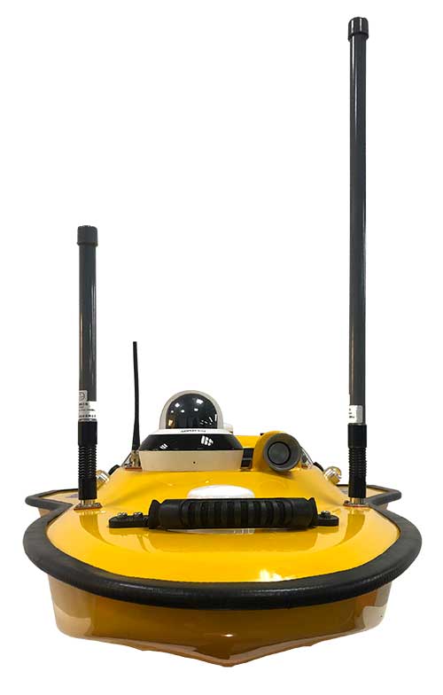
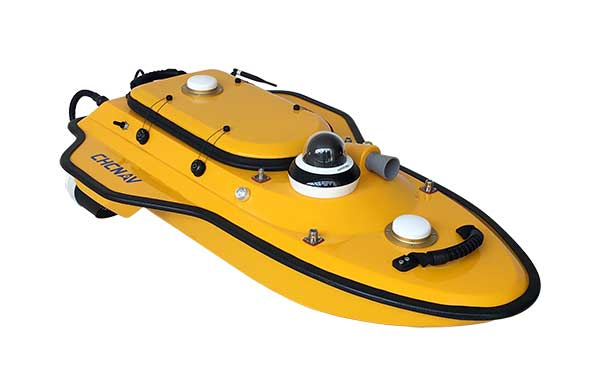
Highly cost-effective autonomous marine drone for bathymetric surveys
Photo: CHC Navigation
The new Apache3 Marine Drone — 2020 Edition provides a series of new features and additional enhancements to make lake, river and coastal hydrographic surveys more productive, according to maker CHC Navigation.
Combining a dual GNSS positioning and heading sensor, a stable and reliable hull attitude and an inertial measurement unit (IMU) sensor, the Apache3 unmanned surface vehicle (USV) allows an uninterrupted survey while passing under bridges.
Its high-efficiency 8-meters-per-second motors and absolute straight-line technology enable a fully automatic, predetermined course in adverse current conditions.
The Apache3 features include:
GNSS/INS control box to maintain high accuracy during transient GNSS outage
Integrated 4G and LAN transmission module
Sonic radar for obstacle avoidance
Automatic return to base planning
360° PTZ camera (pan, tilt, zoom)
Overspeed engines to allow operation in most water conditions
According to CHC Navigation, the Apache3 — 2020 Edition offers an exceptional feature/price ratio, making it one of the most competitive professional marine UAV solutions for single-beam bathymetric surveys.
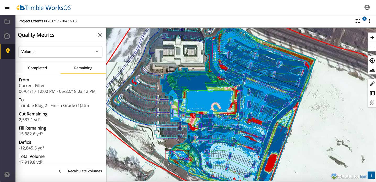
Trimble WorksOS is an upcoming civil construction software-as-a-service (SaaS) operating system. The cloud-based system will integrate data from Trimble and third-party providers across the entire civil construction project lifecycle, including estimating, scheduling, designs and the field.
Beta testing is now taking place for WorksOS, before it is released in the third quarter. Users interested in participating can go to WorksOS.trimble.com.
One-Stop Software. With WorksOS, site supervisors and project managers will be able to log into a single application to track daily production quantities, labor and equipment hours, and equipment maintenance schedules. They will be able to view real-time visibility of cut, fill, volume and compaction data to maximize jobsite productivity.
A user-friendly dashboard enables key personnel, including site supervisors, to adjust daily work targets to ensure work is progressing to plan. Site supervisors will also gain live daily volume calculations, compaction quality metrics and visibility into which machine is working, to monitor progress and determine if the project is on schedule.
Software Connections. Connecting workflows, Trimble WorksOS will integrate Trimble Business Center, Trimble WorksManager, Trimble Siteworks Positioning System, Trimble Earthworks Grade Control Platform and Trimble PULSE Fleet and Equipment Management Software.
Esri will be providing a COVID-19 Response Package for free to all nonprofit organizations responding to the pandemic. According to Esri, this includes data, templates and solutions that are accessible through Esri’s Disaster Response Program.
By mapping data with capabilities such as spatial analysis, Esri’s software allows organizations to track where COVID-19 cases are spreading, and — through predictive modeling — determine where additional capacity will be needed. Using data visualization in maps and dashboards, nonprofits can see affected populations, share information with stakeholders virtually and measure the impact of their response efforts, Esri said.
“Esri enables us to identify vulnerable communities, whether they currently have unmet needs or appear to have a thin cushion with which to absorb a crisis,” said Raj Kamachee, Team Rubicon CTO and CIO. “Thanks to this wealth of location-based data, we have responded not only reactively, but have also been able to reach out proactively to these vulnerable communities, establishing a relationship during ‘blue skies’ so they have someone to call when disaster strikes.”
According to Esri, it has supported more than 10,000 nonprofits to advance their missions with geospatial data and tools through the Esri Nonprofit Program, which was launched in 2010.
“It’s never been more critical to ensure that nonprofits have the solutions that will enable them to target and serve vulnerable populations, understand disease spread, gauge their effectiveness and engage their communities,” said Jack Dangermond, Esri founder and president. “Our company was founded as a nonprofit, and so we share a deep commitment to the goals and mission that these organizations pursue.”
Founded in 1969, Esri provides geographic information system software, location intelligence, and mapping.
SPH Engineering has launched a new product to make bathymetric surveys of inland and coastal water.
The system — an unmanned aerial vehicle (UAV) integrated with an echo sounder — is time- and cost-efficient. It is suitable for mapping, measuring and inspecting tasks as well as environmental monitoring.
The system allows field workers to collect data with high accuracy quickly. It is easily transported, quickly deployed and twice as cost-efficient as traditional methods.
The UAV/echo sounder system can be operated in hard to reach locations, and unsafe or hazardous environments. Locations not reachable by foot or that are dangerous for a human (steep coasts, mining pits, contaminated waters, terrain obstacles, etc.) as well as waters of ponds, lakes, and canals can be reached by the drone.
“Since autumn 2018 we have been getting bathymetry-related requests,” said Lexey Dobrovolskiy, CTO of SPH Engineering. “Analyzing about 150 inquiries, we have come to the conclusion that a drone-based solution could open a new business opportunity for drone service companies to do bathymetry surveys of coastal and inland water, especially those for industrial needs.
“Compared with a standard approach using a boat or an unmanned surface vehicle, a drone could save a lot for its user,” Dobrovolskiy said. “An echo sounder itself could be integrated into a client’s drone with no need to purchase additional equipment. Moreover, it is small and easy to transport and operate. At the same time, such research method guarantees data accuracy and employee safety.”
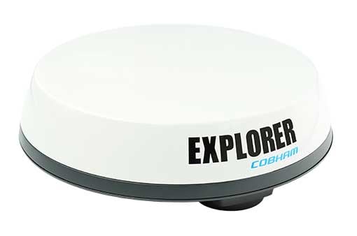
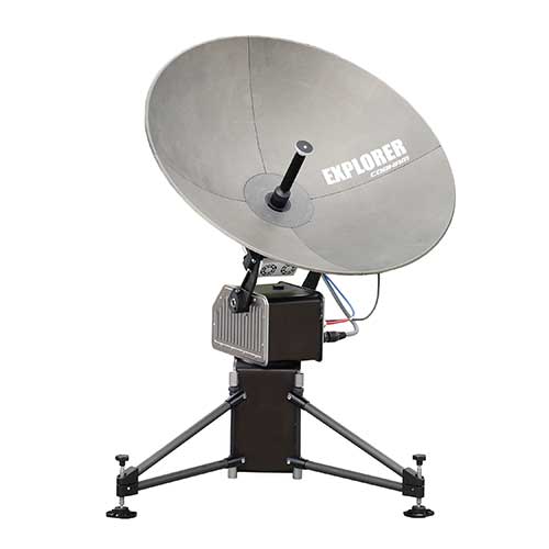
Cobham Explorer 323 and Explorer 6075LX terminals receive Inmarsat type approval
Cobham SATCOM and Inmarsat have announced the type approval of two new land satellite terminals. The low-profile vehicular Cobham Explorer 323 BGAN terminal and the auto-point “fly-away” Cobham Explorer 6075LX VSAT terminal are now fully operational on the Inmarsat network with commercial shipments of each beginning immediately.
Explorer-323. (Photo: Cobham)
The new Explorer 323 terminal represents the first class 12, electronically steerable terminal for use on Inmarsat’s L-band Broadband Global Area Network (BGAN). It combines the slimmest form factor of any vehicular BGAN terminal with a number of new innovative features and sets a new standard in robustness due to its lack of moving parts. In conjunction with Inmarsat’s highly reliable network, offering up to 99.9% uptime, it promises a new standard in mobile communications to organisations operating in remote locations across a wide array of industries.
The class 12 terminal features speeds of up to 384kbps, support for BGAN (data and voice) and BGAN M2M (data) operations, and an integrated antenna and receiver, meaning only a rooftop unit is needed. Additionally, the Explorer 323 has an integrated Wi-Fi Hotspot for setup, management and data access. Developed to integrate seamlessly with Cobham’s PRISM PTT+ offering, the Explorer 323 will enable telemetry and voice communications as well as other uses in remote rail operations, utilities, mining, aid and NGO operations, agriculture, public safety and emergency response.
Explorer-6075. (Photo: Cobham)
Inmarsat has also approved the new auto-point ‘fly-away’ 0.75m Cobham Explorer 6075LX VSAT terminal for its high-speed Ka-band Global Xpress service. The new terminal offers the most reliable and stable connection in its class and features a simplified design, enhanced usability, quick setup and built-in WiFi. With a dynamic auto-pointing correction the terminal maintains its connection even in windy conditions or when pushed or moved, optimising its connection constantly. The Explorer 6075LX also features a considerable reduction in weight versus the Explorer 5075GX for greater portability and will support high-bandwidth applications in broadcasting, resilience and field-office operation.
“We are proud to offer these two game-changing terminals to our partners and customers,” said Mike Carter, president of Inmarsat Enterprise. “Their launch follows an important period of industry consultation, innovation and collaboration between Cobham and Inmarsat. With the Explorer 323 ideal for vehicular tracking and communications and the Explorer 6075 optimised for high-bandwidth operations, both terminals improve upon their predecessors and are set to make ultra-reliable connectivity easier to access in the remotest areas, wherever it is needed most.”
“These two new terminals from Cobham prove that there continues to be innovation occurring in both our L-band and Global Xpress networks,” said Todd McDonell, president of Inmarsat Global Government. “For government users, the 6075LX (or GX6075) provides a fast to set up, easy-to-use, automatic acquisition broadband terminal ideal for first responders who need to access communications at a scene quickly.
“In addition, the Explorer 323 provides government users with a way to maintain on-the-move connectivity regardless of the situation,” McDonell said. “When fixed networks become disabled or degraded, due to events such as natural disasters, the Explorer 323 provides an ideal, low-profile system for routing radio and data connectivity and can be integrated with the emergency services’ existing radio and data networks. We thank Cobham for bringing these products to market. We believe that they will help to deliver new capability for a number of government departments and agencies.”
Inmarsat owns and operates mobile telecommunications satellite networks around the globe, and holds a multi-layered, global spectrum portfolio covering L-band, Ka-band and S-band.
Inmarsat has provided global, L-band services for many decades, which are used by governments, the maritime and aviation industries, and commercial users on land, in sectors ranging from mining and agriculture to rail and transportation.
The frequencies used by Inmarsat to deliver these services are different to those used for GPS/GNSS. All terminals approved for use over Inmarsat’s L-band network (and their other networks) conform to international standards.
In the case of GPS, Inmarsat has exceed these standards by a considerable margin.
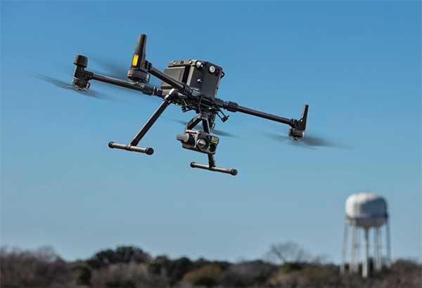
New Matrice 300 RTK and Zenmuse H20 series cameras ready for new generation of work, including digitalization and artificial intelligence (AI)
DJI has unveiled its most advanced commercial drone platform, the Matrice 300 RTK (M300 RTK), along with the Zenmuse H20 Series, a hybrid, multi-sensor camera.
The Matrice 300 RTK UAV from DJI is designed for the next level in data collection and site inspection. (Photo: DJI)
DJI engineered the all-in-one, high-tech solution for areas of work never explored before in precise aerial inspections and data-collection missions.
“With the M300 RTK flying platform and the Zenmuse H20 camera series, we are providing a safer and smarter solution to our enterprise customers” said Christina Zhang, senior director, Corporate Strategy at DJI. “This solution sets an entirely new standard for industrial UAV solutions, significantly enhancing operations across public safety, law enforcement, energy, surveying and mapping as well as critical infrastructure inspections.”
The M300 RTK is the first DJI product that integrates modern aviation features, advanced AI capabilities, six directional sensing and positioning system, a UAV health management system, and 55 minutes’ flight time.
The drone platform has AES-256 encryption and an IP45 weather-resistant enclosure. It has a built-in all-new OcuSync Enterprise transmission system that provides a triple-channel 1080p video transmission signal reaching up to 15 km away.
The M300 RTK can support up to 3 payloads simultaneously and has a maximum payload capability of up to 2.7 kg.
“For our teams working in the oil & gas industry, performance and safety are not optional,” said customer Adam Serblowski, Robotics Theme Lead at Shell. “We cannot compromise on our pursuit of utilizing the best and most efficient tools available. The DJI Matrice 300 RTK proves to be an ideal upgrade over the existing DJI product line, and it helps us to further enhance the benefits of our drone programs. Our productive partnership with DJI will continue to help elevate safety in the world’s largest industry.”
With the Zenmuse H20 Series Camera
Combined, the M300 RTK and Zenmuse H20 Series solution offers users two intelligent ways to collect data:
Smart Pin & Track. Intelligent functions that enhance synchronization of aerial intelligence in coordinated missions. It includes PinPoint, a function that allows users to mark the subject of interest and instantly share the precise location data to a second operator or if necessary to ground teams via DJI FlightHub; and Smart Track, which allows users to automatically detect and track a moving object, even at extreme distances, while synchronising the subject’s dynamic location in real time.
Smart Inspection. A new set of features developed to optimize routine data collection missions such as power lines, railway and oil and gas inspections. It consists of Live Mission Recording for recording sample automated missions in real time; AI-Spot Check, which enables data collection from exactly the same location every time, greatly improving the accuracy of automated missions. After photos from a sample waypoint inspection mission have been recorded, operators are able to mark the subject of interest. During subsequent automated flight missions, AI algorithms perform a comparison between the marked subject and current live view, thus correcting the camera orientation accordingly to deliver accurate and consistent results; and Waypoints 2.0 — an improved mission planning system offering up to 65,535 waypoints, while supporting an array of consecutive actions, 3rd party payloads, and more.
Aviation-Grade Situational Awareness. Inspired by today’s modern aircraft, the M300 RTK features a Primary Flight Display (PFD) that merges real-time flight and navigation data into one integrated display. Besides standard telemetry data like altitude and speed, the M300 RTK PFD provides obstacle data for visualising nearby obstacles during flight, enabling pilots to adjust flight trajectory if needed. These enhancements allow users to keep track of the aircraft while further enhancing the pilot’s situational awareness.
Dual-operator mode. New to DJI’s commercial drone platforms and exclusive to the M300 RTK, is Advanced Dual Operator Mode – multi-pilot control protocols that enable the execution of missions with enhanced safety, reliability and flexibility.
The M300 RTK, when controlled by two pilots, gives each pilot equal access to gain flight-control priority, the transfer of which is displayed by a series of icons on the DJI Smart Controller Enterprise. If one pilot becomes compromised or their controller loses battery or connection, the other pilot gains full control over the M300 RTK and its payloads.
When training new pilots, the teacher/main pilot can safely take over flight control if necessary.
Improved safety and reliability
The M300 RTK comes with new and improved safety and reliability enhancements, including:
AES-256 Encryption: for secure data transmission of the command & control uplink and video transmission downlink.
AirSense (ADS-B technology): for enhanced airspace safety.
Anti-Collision Beacon: for increased aircraft visibility, especially in low-light conditions.
IP45 Protection Rating & Self-Heating Battery: for adverse weather conditions (-20 to 50° C).
6 Directional Sensing and Positioning System: offers a maximum detection range of up to 40 m horizontally, with options to customize the aircraft sensing behavior via DJI Pilot.
As with modern-day jetliners, the M300 RTK offers an integrated UAV Health Management System (UHMS) to optimize fleet maintenance. It records the aircraft’s flight data throughout its entire lifecycle, and utilizes the drone’s hardware and software systems to understand current aircraft performance and determine when it should be serviced. Taking advantage of this new system, users can get a quick overview of all critical aircraft systems, manage firmware updates across an entire fleet, track pilot hours and review flight missions.
DJI Zenmuse H20 Series
The new camera payloads are designed to improve mission efficiency. The Zenmuse H20 series offers DJI’s first Hybrid multi-sensor solution, allowing capture of any kind of images for industrial applications and public-safety missions where efficient time management and immediate access to multiple layers of visions are paramount.
The H20 Series is IP44 rated, which protects enclosures from splashes of water from any direction.
The H20 series comes in two versions:
The H20, a triple sensor with a 20-MP, 23x hybrid optical zoom camera, a 12-MP wide camera, and a laser range finder covering distances from 3 to 1200 meters
The H20T, a quad sensor that adds a 640 x 512 radiometric thermal camera, allowing operators to see what is invisible to the human eye using high thermal sensitivity at 30 frames per second video definition.
Integrated user interface
To enable pilots to operate so many sensors at once, the accompanying DJI Pilot app interface was redesigned. The new user interface lets pilots quickly switch between cameras and simplifies the process of zooming in and out by letting pilots preview the zoom field of view on top of the wide angle or thermal camera footage.
With a multi-sensor integrated user interface, the Zenmuse H20 series allows users to smoothly switch between wide, zoom or thermal cameras. It also includes features for maximum flexibility when used on time-sensitive missions.
High-Res Grid Photo: Captures in one snap detailed imagery of defined subjects with the help of a custom grid. The images can be stored for later detailed inspection.
One-Click Capture: Captures videos or photos of up to three cameras simultaneously without having to manually switch between camera views or repeat a mission.
Night Scene: Gains clearer visibility when lighting conditions are not optimal.
The M300 RTK and Zenmuse H20 series are available for pre-order from official DJI Enterprise dealers and will start shipping in Q2 2020.
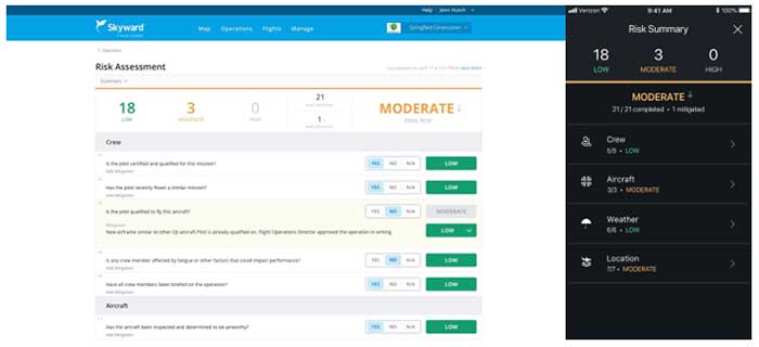
Skyward has released a new risk assessment tool for its Aviation Management Platform, which is designed to help drone program managers proactively identify and document critical risks to an operation.
For assessing risk, users answer a series of risk questions developed by Skyward’s drone experts and based on aviation best practices. Each answer is assigned a risk level: low, moderate or high. As each question is answered, an overall risk summary score is generated based on the highest level of risk present, Skyward said.
Photo: Skyward
Users can also add mitigation for any risk level by adding explanations and adjusting the risk levels. The mitigated risk will be noted in the summary, and the note will be synced across the Skyward software platform.
Skyward, based in Portland, Oregon, develops drone programs for industries such as construction, industrial inspection, media, insurance, real estate, mining, precision agriculture and more. Skyward was acquired by Verizon in 2017.
Allison Barwacz is the digital media manager for North Coast Media (NCM). She completed her undergraduate degree at Ohio University where she received a Bachelor of Science in magazine journalism from the E.W. Scripps School of Journalism. She works across a number of digital platforms, which include creating e-newsletters, writing articles and posting across social media sites. She also creates content for NCM’s Pit & Quarry magazine, Portable Plants magazine and Geospatial Solutions. Her understanding of the ever-changing digital media world allows her to quickly grasp what a target audience desires and create content that is appealing and relevant for any client across any platform.