Publicerad den Lämna en kommentar

Fortem Technologies enables safe drone delivery of medical supplies in North Carolina

Photo: Fortem Technologies

Photo: Fortem Technologies

Fortem Technologies has completed the first phase of the U.S. Department of Transportation’s Unmanned Aircraft Systems Integration Pilot Program (UAS IPP) in North Carolina.

As part of the program, Fortem is conducting tests to monitor the airspace around WakeMed Hospital in Raleigh, tracking manned flights alongside the UPS Delivery Corridor, and delivering medical test samples via unmanned drones. Fortem has been using its TrueView radar and SkyDome software system to ensure UAS operations and drone deliveries do not interfere with medical helicopters flying in and out of the area, as well as alert drone operators of any potential non-cooperative aircraft in the vicinity.

According to the company, it was able to accurately and consistently track incoming medical helicopter traffic, providing real-time alerts to Airmap, an unmanned service supplier.

“By monitoring the airspace and creating a service that ensures the safe use of unmanned air vehicles, we will expand from these initial drone deliveries to greater geographical reach and more sophisticated roles for unmanned drones,” said Adam Robertson, CTO of Fortem Technologies. “With Fortem’s ability to offer real time data and analysis of airborne threats, we can start to see additional support for things like search and rescue operations, first responders, and increased shipments of critical supplies to remote locations. None of this can happen without the trust that our systems are effective and safe.”

The North Carolina Department of Transportation (NCDOT) Division of Aviation partners, including WakeMed Hospital, are testing drone operations that will soon go beyond a pilot’s visual line of sight to provide efficient and safe drone operations with the ultimate goal of helping to improve healthcare access for all North Carolinians.

“Ensuring the safety of manned aviation is paramount for unmanned flight operations, yet successful coordination of the two is not an easy task,” said Basil Yap, UAS program manager at NCDOT. “The phase one testing has shown promising results and we are hopeful the phase two operations will provide the information we need to receive a beyond-visual-line-of-sight waiver from the Federal Aviation Administration.”

Fortem will continue to provide situational awareness and secure the airspace into the next phase of the program, the company said. NCDOT, as part of the USDOT UAS IPP, will continue to support its partners’ operations at WakeMed throughout the year until the program’s conclusion in October.

Publicerad den Lämna en kommentar

5th annual FAA UAS Symposium goes virtual because of COVID-19

Logo: FAA UAS SymposiumThe Federal Aviation Administration (FAA) and the Association for Unmanned Vehicle Systems International (AUVSI) will host the 5th annual FAA UAS Symposium virtually, rather than in-person in Baltimore. The event will take place June 16-18.

This decision was made as a result of the ongoing concerns caused by the COVID-19 pandemic, the organizers said.

The FAA and AUVSI also will be hosting a series of virtual events that will address the content already planned for this year’s program. The fist will take place in early summer and will focus on UTM and international UAS integration. The second will take place in late summer with a focus on updates to the Integration Pilot Program and public safety operations.

According to organizers, those registered for the 5th annual FAA UAS Symposium will receive a separate message in the coming weeks to confirm options for participation in the virtual events.

Those selected as speakers for the 5th annual FAA UAS Symposium will receive a separate message from AUVSI’s Industry Education Team to confirm participation, as well as any schedule changes.

Publicerad den Lämna en kommentar

Altitude Angel releases Scout, an open-source remote ID platform 

Altitude Angel logoAltitude Angel, a London, U.K.-based unmanned traffic management (UTM) technology provider, is releasing an open-sourced project, Scout.

Scout’s hardware and firmware enable drone manufacturers, software developers and commercial drone pilots to quickly connect to its global UTM.

Primarily intended for use in commercial and industrial drone applications, Scout provides the capability to securely obtain and broadcast a form of network remote ID, widely seen as a necessary step for enabling routine drone use and flights beyond visual line of sight.

Because it is open source, both the hardware and the firmware can be enhanced and incorporated into a virtually limitless set of scenarios, according to Altitude Angel.

Altitude Angel also has made available a surveillance API that allows integrators to both share and receive flight data from a variety of sensors and devices in near real time, providing a comprehensive real-time picture of the airspace. 

While many remote ID systems are broadcast only, Scout offers two-way communication and is fully open-sourced. The ability to talk back to the drone enables the Altitude Angel UTM service to help the drone avoid collisions with other aerial vehicles, or restricted airspace.

From launch, Scout will use identifiers obtained freely from Altitude Angel’s GuardianUTM platform. It will work in combination with a pre-flight (flight-plan sharing) service and is supported through integration with Altitude Angel’s Tactical Conflict Resolution Service.

Scout will enable the drone to report its real-time location using GPS-type sensors and relay this data via a secure, encrypted mobile communications link across 3G, 4G and 5G networks to Altitude Angel. It is powered by an internal rechargeable (via micro USB) lithium battery.

Altitude Angel has also provided reference design plans for the case that can be 3D printed. Scout has been designed to satisfy emerging network remote ID standards, such as ASTM.

Because the firmware is open source, the telemetry can be sent to other systems as required by the implementor.

A two-wire I2C upgrade to the circuit schematics, plus version 2 of the firmware (both scheduled for June), will subsequently enable the full two-way communication between the Scout device and the drone’s onboard systems, allowing the drone to respond directly to information received from the UTM.

In the interim, early adopters will have the opportunity to begin to integrate with Altitude Angel’s UTM services, test the hardware and test communication. Position data Altitude Angel receives from Scout is then automatically used by its Flight Information Management System (FIMS) to help provide traffic deconfliction.

Plans, firmware and schematics can be accessed via the Altitude Angel GitHub repositories.

Publicerad den Lämna en kommentar

NavVis launches VLX wearable mapping system

The all-in-one reality capture capabilities of NavVis VLX include both survey-grade point clouds and high-resolution panoramas. (Photo: NavVis)

The all-in-one reality capture capabilities of NavVis VLX include both survey-grade point clouds and high-resolution panoramas. (Photo: NavVis)

NavVis has launched NavVis VLX, a wearable mapping system that captures high-quality data in built environments such as construction sites, staircases and small technical rooms.

The all-in-one reality capture capabilities of NavVis VLX include both survey-grade point clouds and high-resolution panoramas. The combination of high-quality data capture and a compact, economical design will transform the way architecture, engineering and construction (AEC) projects are captured with fast, efficient scanning for BIM and CAD applications, while also extending the scope of projects to new deliverables such as web-based digital twins, the company said.

NavVis VLX is equipped with two lidar sensors and captures survey-grade point clouds using the company’s SLAM technology, which was originally developed for the the NavVis M6 indoor mobile mapping system. NavVis VLX also captures high-resolution panorama images in a complete 360-degree field of view.

According to the company, this wearable device gives the operator more control over where the sensors are scanning. It also allows the user to view and interact with the built-in screen that provides live feedback of what has been scanned and the quality of the data being captured.

“We designed NavVis VLX to provide the AEC industry with a compact, versatile device that efficiently captures buildings and still delivers survey-grade point clouds,” said Georg Schroth, NavVis CTO. “Knowing that there is still an unmet need for high-quality mobile data capture in a wider range of building documentation applications, we set out to develop a more versatile device that can achieve what NavVis M6 does at a smaller scale and on a lower budget.”

According to NavVis, the data captured by the VLX can be applied to a wide range of applications, including conventional building documentation such as CAD drawings and BIM models, as well as to innovative digital twin solutions, such as NavVis IndoorViewer.

NavVis, headquartered in Munich, Germany, is a global provider of indoor spatial intelligence technology and solutions for enterprises. The company also has offices in New York and Shanghai.

Publicerad den Lämna en kommentar

QGIS Server and OGC API Features

Based on text and information from Paul Blottiere and Alessandro Pasotti (both QCooperative)

QGIS Server implements a number of OGC services, such as WMS, WFS, WCS or WMTS and extends these services where useful. Thanks to the efforts of a number of QGIS Server developers and companies, QGIS 3.10 (and 3.4 before) had been certified by the OGC for the WMS 1.3.0 service, and is also a WMS reference implementation.

alt wording

Last year in 2019, a new protocol has been developed and named OGC API Features (commonly known as WFS3). With the purpose of having an up-to-date QGIS Server, both OSGeo and QGIS.ORG have dedicated funds to work on the implementation of this brand-new service: but we wanted to do it right, so the ambition was also to reach the OGC certification!

This new protocol with REST interfaces gets rid of the XML specification to use the OpenAPI standard as well as the JSON open format instead. In other words, it’s not just another protocol to support, but a whole package of changes and fresh mechanisms to work on. It was quite a challenge!

QGIS core developers of QCooperative were remotely participating in OGC sprints to closely monitor the development of the new OGC API Features protocol. Hence, we started its implementation and a fully operational version landed in QGIS Server 3.10.

Implementation and features

As a reminder, the WFS protocol allows to query, retrieve and manipulate vector features, unlike the WMS format which provides raster outputs. OGC API Features is the natural continuity and consistently provides basic mechanisms to retrieve features and corresponding information in a specific area (the famous GetFeatureInfo request in WFS 1.X).

In addition, QGIS Server also provides transactions for the OGC API Features protocol. This means basically that we can update, insert or delete features in the underlying data. And of course, everything can be easily reached and configured through QGIS Desktop.

Yet another interesting thing to note is also the full support of the date and time filtering. Nifty!

And last, but not least, QGIS Server 3.10 provides a default HTML template with an embedded map to explore the data served by the server. There’s literally nothing to configure, it’s just there as soon as you work with the OGC API Features protocol :).

alt wording

OGC Certification

Once the implementation was completed, we started to address the OGC certification goal. To avoid unwanted regressions along the way, we first added nightly tests by updating the dedicated QGIS repository for OGC tests. From that moment, HTML reports are available day-to-day to monitor development over time.

Then, some bugfixes and backports later, we’re finally there: OGC tests are green on the development version, 3.12 and 3.10 releases. Yippee!

alt wording

Conclusion

Now that everything is in order, the last step is to start the formal OGC certification process. From now on, the dedicated QGIS OGC Team takes care of further operations.

Nyhet från QGIS, orginal inlägg

Publicerad den Lämna en kommentar

ION to host webinar on sample correlation on SISRE overbound for ARAIM

Logo: ION

The Institute of Navigation (ION) will be hosting a complimentary webinar, “Impact of Sample Correlation on SISRE Overbound for ARAIM,” at 12 p.m. ET on May 28.

This topic was originally presented at ION GNSS+ 2018 and published in the Spring 2020 issue of Navigation, Journal of the Institute of Navigation, Volume 67, No. 1, pp 197-212, by Dr. Santiago Perea Diaz, Prof. Michael Meurer and Dr. Boris Pervan.

According to ION, this paper analyzes the effect of error correlation on the SISRE bounding for GPS and Galileo satellites. For a given period of data collection, it computes the effective number of independent samples contained in a dataset applying an estimation variance analyses. Results show that the time between effective independent samples is highly dependent on the constellation and onboard clock type. On one hand, GPS satellites equipped with Rubidium clocks exhibit significantly longer error correlation than those with onboard Cesium clocks. On the other hand, Galileo satellites show substantially shorter correlation time among samples with less variability on a monthly basis, ION added.

This paper also introduces a methodology to compute SISRE bounding accounting for the limited number of independent samples, ION said. Using a Bayesian approach, it computes the so-called uncertainty factor by which the Gaussian distribution needs to be inflated in order to account for the observation data independence.

Register for the webinar here.

Publicerad den Lämna en kommentar

Veripos offers LD900 quad-band GNSS receiver for marine environments

Photo: Veripos

Photo: Veripos

Veripos has released the LD900, a quad-band GNSS receiver capable of tracking GPS, GLONASS, BeiDou, Galileo and QZSS constellations to provide reliable and accurate positioning. Access to multiple GNSS signals allow for better satellite availability and reduce the impact of satellite masking or blockage, which can affect positioning.

LD900 also receives L-band signals on multiple channels, providing access to the worldwide independent correction links and services provided by Veripos. With correction data available simultaneously from up to three correction satellites, the impact of satellite masking can be minimized to ensure reliable reception of correction data. Using the independent L-band RF input on the LD900 allows the connection of a dedicated L-band antenna ensuring optimal reception of correction services, especially at high latitudes, the company said.

Veripos provides accurate and reliable positioning for all marine applications via their redundant positioning and multi-frequency precise point positioning (PPP) Apex and Ultra services.

The Apex5 correction service utilizes all GNSS constellations delivering 5cm positioning accuracy for use in the most demanding offshore applications. Real-time kinematic (RTK) corrections can be utilized by the LD900 for applications where this service is required.

The intuitive color display and navigation menu makes setup, configuration and system status monitoring simple. The display also helps troubleshoot issues with the LD900 allowing faults to be quickly diagnosed and resolved. The LD900 can also be configured remotely through the Veripos Quantum software.

Features and Benefits

  • Supports decimeter-level multi-constellation positioning with Veripos Apex and Ultra PPP correction services
  • Multi-channel L-band allows simultaneous tracking of 3 Veripos correction service satellites
  • Independent L-band RF input
  • Easy-to-use, intuitive, color display for simple configuration and monitoring
  • Advanced signal filtering mitigates the effects of interference from other transmitters
  • Optional ALIGN GNSS heading solution
  • Optional MSK Beacon receives corrections from IALA marine radio beacon network
  • Automatic 72-hour rolling data log for incident support
Publicerad den Lämna en kommentar

Greetings from your new QGIS project Chair

Dear community,

First of all, I would like to thank Paolo for his work during the last two years as Chair and for the years before that, and years to come in his role as PSC member. I’m looking forward to keeping up the good work with him.

Secondly, I would like to thank all the community voting members for all the great inputs during the discussion phase of the AGM and for the fantastic participation in the voting process where we had more than an 80% turnout.

It is a pleasure to see that besides approving the more formal points (annual report, financial report, budget and auditors), the AGM approved all matters arising:

  • We now have two new honourable voting members: Harrissou Sant-anna and Nyall Dawson. Honourable members are specially designated voting members, whose position does not need to be affiliated with a country user group. Congratulations, and thank you, you are both such an inspiring example to our community!
  • Many QGIS users and contributors are geoscientists or geoinformatics specialists. As such, we need to act responsibly and serve as role models. Thanks to the approval of our new environmental policy, QGIS.ORG and the QGIS community committed ourselves to act responsibly regarding our actions and activities where it has any relevant influence on the environment. This will mainly affect our server infrastructure and our physical contributor meetings. The complete policy can be found in appendix 1 of our AGM minutes or on our website.

Beyond thanking Paolo as outgoing chair, I’d especially like to thank Tim, Andreas, Anita and Jürgen for the great work they are doing in the PSC and in general the incredible drive they have in helping to make QGIS thrive. I’m sure that with the help of our new Vice-Chair Alessandro Pasotti we’ll be able to take QGIS to even greater heights. Welcome, Alessandro!

Last, but definitely not least, I’d like to thank every single member of this amazing community for all your help documenting, coding, translating, testing, designing, teaching, supporting and in general spreading the QGIS love.

I never thought, when I first started using QGIS 0.6 in 2005 that 15 years later I would be given the honour of becoming the official face of such an amazing heart.

Have a great week, rock on QGIS!

Marco Bernasocchi

Incoming Chair of the QGIS.ORG Board

Nyhet från QGIS, orginal inlägg

Publicerad den Lämna en kommentar

Harxon debuts ruggedized antenna HX-CVX600A for i-construction machining applications

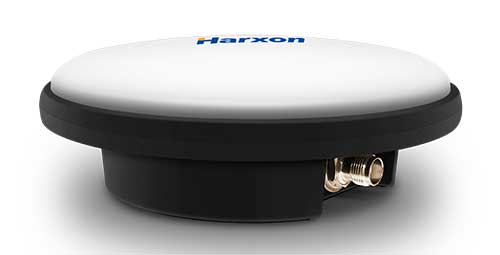
Ruggedized GNSS antenna HX-CVX600A. (Photo: Harxon)

Ruggedized GNSS antenna HX-CVX600A. (Photo: Harxon)

Harxon has launched a ruggedized GNSS antenna for applications subject to high shock and vibration environments such as i-construction machining applications. Integrated with reliable signal tracking and strong anti-interference performance, the IP69K ruggedized HX-CVX600A antenna provides end users with millimeter accuracy, durability and productivity, the company said.

I-construction promotes the use of automated machines on construction sites to improve productivity and provide support to workers.

The Harxon HX-CVX600A offers full support for reliable and consistent satellite signals tracking, including GPS, GLONASS, Galileo and Beidou, QZSS, IRNSS and SBAS, as well as L-band correction services.

By exhibiting a very stable phase center that adopts multipoint feeding technology, exceptional low elevation satellite tracking with symmetric radiation patterns, high gain with ultra-low signal loss, as well as outstanding wide-angle circular polarization (WACP),  the Harxon HX-CVX600A performs with remarkable positioning accuracy and provides end users with full control of the job site, performing tasks more productively, meeting tighter positioning specifications, and avoiding rework caused by inaccurate positioning.

The HX-CVX600A GNSS antenna of Harxon also provides superior anti-interference performance. Its advanced low noise amplifier (LNA) excels in improved signal filtering and out-of-band rejection and restrains electromagnetic interference. It also provides strong multipath reduction capacity over all GNSS frequency bands for consistent and reliable GNSS signals, even under complicated environments such as congested urban areas or communication base stations.

The Harxon HX-CVX600A compact and low-profile antenna is Harxon’s first antenna with exceptionally firmness for hash operation environment as construction industry. The upper cover of the antenna is made of material with excellent chemical and high heat resistance. Its aerodynamic enclosure withstands exposure against dust, rain, splash or sunlight. Screws and pole mounts are both available, offering flexible installation.

The Harxon HX-CVX600A ruggedized antenna is now open for pre-sale; contact sales@harxon.com.

Publicerad den Lämna en kommentar

GSA, European Commission leverage Sixfold expertise to develop Galileo Green Lane app

Photo: shotbydave/E+/Getty Images

Photo: shotbydave/E+/Getty Images

The European GNSS Agency (GSA) has collaborated with the European Commission to develop the Galileo Green Lane app, a mobile solution designed to facilitate the free movement of freight, reduce waiting times at European Union (EU) borders and prioritize essential goods during the COVID-19 pandemic response.

According to GSA, for border control authorities, the app provides a real-time visualization of the situation at border crossings, along with regular updates on the traffic flow situation.

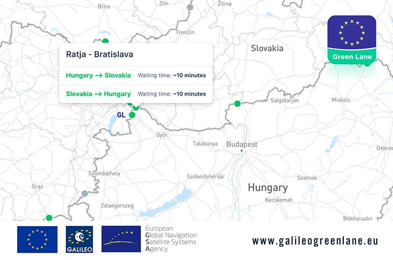
For truck drivers, the app provides a real-time visualization of borders, through an EU-wide map indicating crossing times. This enables logistic companies and drivers to better prepare their routes, having advance knowledge of the waiting time at each border crossing, GSA said.

The Galileo Green Lane app being used for the border of Ratja, Hungary, and Bratislava, Slovakia. (Screenshot: ©European GNSS Agency)

The Galileo Green Lane app being used for the border of Ratja, Hungary, and Bratislava, Slovakia. (Screenshot: ©European GNSS Agency)

The app also offers a real-time overview of border traffic hold-ups, built on the foundation of Sixfold’s COVID-19 map. In mid-March, Sixfold began to provide supply chains, retailers and shippers with a free live border crossing map, which is updated in real-time.

“With the Galileo Green Lane app, the GSA is fulfilling its mission to address economic and societal challenges by leveraging the European GNSS capabilities,” said Pascal Claudel, acting executive director at the GSA.

The app has been tested at border crossings in Hungary and the Czech Republic, while other countries, including France, Greece, Italy, Romania and Spain, are about to start testing, GSA added.