Publicerad den Lämna en kommentar

SoftBank Corp., u-blox to collaborate on global GNSS augmentation services

Companies to develop common GNSS augmentation services for Japan, the United States and Europe

Image: the.epic.man/iStock/Getty Images Plus/Getty Images

Image: the.epic.man/iStock/Getty Images Plus/Getty Images

SoftBank Corp., ALES Corp. and u-blox AG have signed a memorandum of understanding to cooperate in GNSS augmentation services for global markets.

SoftBank provides the “ichimill” GNSS augmentation service in Japan, its subsidiary ALES operates a business that generates and delivers positioning correction data, and u-blox is a global provider of positioning services for the automotive, industrial and consumer markets.

U-blox also provides electronic components for wireless communications and the PointPerfect GNSS augmentation service in Europe, the United States and other countries and regions.

Through this business collaboration, SoftBank, ALES and u-blox will construct GNSS augmentation infrastructure for Japan, Europe and the United States, develop GNSS receivers and devices, and expand service areas.

Collaboration Background

Since November 2019, SoftBank has been offering ichimill, a GNSS augmentation service that offers highly accurate positioning with a margin of error of a few centimeters in the Japan market. In addition to providing technology that enables the generation and delivery of correction data, ALES has been offering a centimeter-level positioning service to consumers in Japan since August 2020.

In July 2021, u-blox began providing PointPerfect, a PPP-RTK-based GNSS augmentation service, which is now available in the contiguous United States and Europe.

GNSS augmentation services like these are mainly offered separately by country and region. Client companies, which include global automotive manufacturers and agricultural machinery manufacturers, sign up for separate service contracts in each country and region, making GNSS receiver configuration more complex.

Collaboration Overview

To offer global GNSS augmentation services, SoftBank, ALES and u-blox will study the following initiatives.

  1. Develop a global correction data delivery infrastructure. GNSS augmentation services use correction methods that differ by country and region, and there is a wide variety of correction signal formats. In 2022, the three companies will consider developing a correction data delivery infrastructure that delivers unified correction signal formats for use in any country or region. With this infrastructure, companies using ichimill or PointPerfect will be able to conduct GNSS augmentation if they are in range of both services, which will eliminate the need for separate service contracts by country or region.
  2. Jointly develop global-compatible devices. In addition to correction data delivery, an environment that allows for the easy implementation of GNSS receivers and other devices is necessary for GNSS augmentation services. In conjunction with the launch of ichimill, SoftBank developed its own GNSS receivers and is offering them in Japan. The three companies will consider jointly developing GNSS receivers and modules that can be used globally.
  3. Greater GNSS augmentation accuracy and service area expansion. The companies will collaborate closely to ensure that the performance of the services in all the regions covered are comparable. This is important to provide a consistent customer experience across all regions. Furthermore, the three companies plan to study service expansion into other areas, including Asia. SoftBank is promoting the deployment of non-terrestrial network (NTN) solutions that encompass satellite- and stratospheric-based telecommunication platforms to provide connectivity to the sea, the sky, developing countries and rural areas lacking internet infrastructure so everyone around the world has access to the internet. The three companies will consider the development of NTN-linked services, such as correction data delivery using small amounts of data in a way that is suitable for NTN bandwidths.
Publicerad den Lämna en kommentar

What the mind’s eye sees: The surveyor and spatial intelligence

If we introduce children who have an interest in visualization of puzzles, art and mathematics to the appropriate training methods, we can help train future STEM students that could turn into our next generation of surveyors and geospatial professionals.

Many of us who were children before computers, the internet, and lots of electronic gadgets used our imagination to create fantasy worlds and environments. Many of these visions were drawn on paper using pencils, crayons and paints to recreate those images so we could share them with others. While the world in which we live, work and play exists in three dimensions, our minds were kept to a two-dimensional level because of how ideas and visions were made possible only on flat surfaces or media.

Photo: Tim Burch

Photo: Tim Burch

Surveying has been no different through the centuries. Surveyors have generally divided their work into two categories: land boundaries and topography. Typically, the surveying process of parcel establishment and retracement has been a two-dimensional task, while topographic surveys utilize elevations to determine relief and drainage patterns. This survey information was drawn as graphic depictions on paper to provide the pertinent data to users. It has been generally impossible to express survey data, including boundaries and topography, in a three-dimensional form as the human eye sees it. Many different professions have tried to present information beyond the second dimension but with little success.

The beginning of the imagery revolution

In the 1800s, the invention of photography brought a new medium into our world by capturing images of still life onto a two-dimensional format. Photographs, when taken at a proper angle and lighting, helped establish depth to an image, but only if taken in the right context and for the correct purpose. The 1830s brought us the stereoscope, utilizing two slightly different versions of the same photograph to be viewed through a binocular device and “tricking the brain” into establishing depth within the image. This is one of the first examples of using a visual technique to teach our brain to gather 3D information based upon a 2D image or dataset.

The 1800s also brought us the “motion picture” or movie as we traditionally know it. Ranging from 16 to 24 frames per second and using varying methods to “flash” through a sequence of progressing images, the movie brought another new medium into our world. While silent films were the predominant movie type, several inventors conceived varying ways to produce movies in three dimensions. The most popular type was the stereoscope movie, but moviegoers found it too cumbersome to sit behind a stationary set of stereoscope glasses for the length of the film.

Another innovation from the 1890s was the creation of the anaglyph. This viewing style required glasses with a red lens for the left eye and a blue lens for the right eye to view two negative images that form a stereoscopic subject. These images remained popular well into the 20th century, with the concept crossing over into films.

Image: clavivs/iStock/Getty Images Plus/Getty Images

Image: clavivs/iStock/Getty Images Plus/Getty Images

Artistic interpretation and presentation

It is one thing to see an object in real life and make a mental note of what it looks like from varying angles. It is another thing to accurate depict the same object on a two-dimensional medium that gives the viewer the same perspective of the real object. Artists who can simulate depth on an otherwise flat media with drawings and paintings are rare; one of the most famous is M.C. Escher (1898–1972), a Dutch artist known worldwide for his “impossible” drawings and sketches based upon mathematical figures. He had a gift of seeing his art in three dimensions and translating it to various mediums.

But not every drawing is an artistic interpretation. Ideas that come to fruition in an inventor’s mind often get drawn to scale on paper for sharing with others. Mechanical engineers often used a system known as isometric drafting, a method of drawing a three-dimensional item to join an isometric view, giving the shape within the drawing a sense of depth.

Toys and games as training tools

Little did we realize as children and young adults that many of the inventions for imagery led to many popular toys in our history. For instance, the View Master was invented in 1938 and widely introduced at the 1939 New York World’s Fair. This toy turned the stereoscope concept into a sightseeing treasure. In the 1960s, the photographic reels viewed within the View Master began featuring television, movie and cartoon characters in various storylines. It is estimated that more than 1.5 billion reels have been produced covering sites and subjects from every corner of Earth.
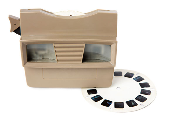
Photo: DieterMeyrl/iStock/Getty Images Plus/Getty Images

Photo: DieterMeyrl/iStock/Getty Images Plus/Getty Images

There have also been many variations on the optical illusions designed to make one see a certain image, then suddenly see something completely different. One significant entry in the illusion category is Magic Eye, a series of images based upon single-image random-dot stereograms, or autostereograms. These images utilize computer graphics to “hide” a 3D image within patterns of other shapes and trick your brain into focusing on the hidden subject. After more than 25 years and hundreds of millions of copies of its books, Magic Eye is still challenging people to “see” objects in three dimensions.

However, the biggest training device for seeing 3D objects in a 2D medium happened within the same timeframe and has no plans for slowing down any time soon: video games. The video game platform has reinvented itself several times in its short life, but the premise behind the visualization remains the same. Some of the systems allow for virtual reality glasses or goggles to enhance the user’s experience.

“Yes, in fact, my child is gifted…”

The scientific term for this visual ability is called spatial intelligence. Spatial intelligence has and attracted attention in recent years for helping determine a person’s strengths and capabilities. Spatial intelligence, also known as spatial reasoning, is one of the nine intelligences in the Theory of Multiple Intelligences proposed by psychologist Howard Gardner. In his theory, Gardner challenged the narrow definition of general intelligence with his proposal of nine types of intelligences:

  • spatial
  • linguistic
  • logical-mathematical
  • musical
  • kinesthetic
  • interpersonal
  • intrapersonal
  • naturalistic
  • emotional

Often, we know people who display various traits as defined within this list of intelligences. Someone with linguistical intelligence is well-spoken, enjoys reading and writing, and can explain a situation or story well. A person with logical-mathematical intelligence solves difficult computations and is a tremendous problem solver. Musical intelligence is found in one who is a “natural” at playing a musical instrument or singing. The pattern continues with the rest of the list and helps to establish strengths within one’s abilities. Most of the intelligences are born within a person, while a few can be somewhat taught. Finding the people with the strongest abilities in a given trait leads us to the highest performers.

Spatial intelligence is observed in those who like to draw, design or build things, and are quick to mentally manipulate objects to solve puzzles. David Lohman, a researcher who has spent most of his career studying the subject, defines spatial intelligence as “the ability to generate, retain, retrieve and transform well-structured visual images.” Individuals with highly developed spatial intelligence have a unique ability to view objects and imagine them in rotated positions or different angles, and how a group of items can fit together.

Photo: fstop123/iStock/Getty Images Plus/Getty Images

Photo: fstop123/iStock/Getty Images Plus/Getty Images

How important is spatial intelligence as a teachable subject?

In the past, having spatial intelligence was a naturally occurring trait. Important figures in history, including Picasso and da Vinci, are a few examples of individuals with high spatial intelligence. Clinical research, however, has determined this ability to be a skill that is actually trainable in many instances. If we introduce children who have an interest in visualization of puzzles, art and mathematics to the appropriate training methods, we can help train future STEM students that could turn into our next generation of surveyors and geospatial professionals. By employing a spatial component into lessons and challenging students through visual tasks, they begin to identify objects and other matter into geometrical patterns and spatial relationships. Students who display these spatial characteristics are better at critical thinking and problem solving, which in turn gives them more self-confidence.

Another important characteristic of spatial intelligence is that gender does not play a large role. Studies have shown that with training and a challenging curriculum, both boys and girls are prone to excel at gaining more spatial awareness and ability to solve problems. The key to maintaining this equality in spatial intelligence is to provide equal education and training for both genders in the formative years. Often, only boys are steered toward sports, math and science while girls are directed to the arts and humanities. By providing all children with the opportunity to experience spatial learning, they will begin to build skills that will help them for a lifetime.

What does spatial intelligence have to do with GNSS and surveyors?

It has everything to do with geospatial data! Literally all survey data collected these days is geospatial in nature and contains three-dimensional coordinate values. Why is the evolution of seeing 3D objects in 2D spaces so important? Not everyone can visualize these shapes immediately in two dimensions. If we are able to identify those with strong spatial intelligence levels, we can steer them into the many variations of geospatial fields and surveying.

Previously, our surveying profession dealt with data collection in small doses. A good day of topographic surveying might see a crew collect 1,000- to 2,000 points. (Not to mention the days before data collectors!) Because the area covered within the day’s work was significant, the surveyor did not have to look at a “big picture” of terrain and improvements. These smaller chunks, even though they were collected with elevations, were plotted in 2D. The contours drawn using the points were simply grade proportions between points and did not produce a 3D effect.
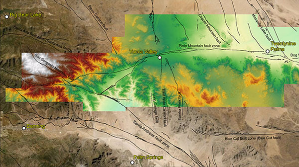
Lidar data collected in May 2021 for a study of the San Andreas Fault system. (Image: Stephanie Dudash, USGS)

Lidar data collected in May 2021 for a study of the San Andreas Fault system. (Image: Stephanie Dudash, USGS)

Fast forward to the surveying instruments and CAD software in today’s work environment. Remote sensing through UAV-mounted, vehicle-mounted and terrestrial-based instruments collect thousands to millions of points (per second in most cases), and we get the resulting point clouds produced by these instruments. It is equally important to see the spatial relationship of the terrain, improvements and overall site conditions for both the surveyor and the CAD technician. We now have data that literally blankets the surface of the subject site, and it is up to both field staff and office staff to correctly interpret that data for the prospective client. Having surveyors and technicians with a reasonable sense of spatial intelligence gives the data a better chance of correct interpretation and depiction.

Many STEM industry experts are beginning to work with researchers on creating more educational curriculum based upon the various intelligence categories previously discussed. Spatial intelligence will continue to increase as an influencing factor in helping students decide on their career choices. Having our educational system also increase the amount of spatial relationship curriculum within their core teachings, we can help grow our potential STEM professionals and technicians for generations to come.

While many professions and occupations continue to struggle in anticipation of their future need for employees, the surveying and geospatial professions can help do something about it now. Encourage your kids to play video games, fly their drones, play sports, and solve complex problems. Playing and learning today may help them with their future profession. If not, they can enjoy themselves while they can. Don’t we all wish we were kids again some days?

Publicerad den Lämna en kommentar

Receive RTK correction data with a VBOX NTRIP Modem

[SPONSORED CONTENT]  VBOX NTRIP Modem allows you to receive RTK correction data via internet, without having to operate your own base station. By accessing public or commercial RTK networks, correction messages from a grid of permanent base stations can be received by either Wi-Fi or 4G cellular connection. Utilizing Network RTK overcomes the range restrictions of a single base station, allowing for centimeter-level RTK accuracy to be achieved over significant distances. Additionally, receiving corrections via internet rather than radio provides a more reliable signal reception as interference from changes in elevation or topographical obstacles are minimized.

If your use of RTK corrections is localized, then you can still gain the benefits of increased range and signal reliability offered by utilizing internet-based correction messages. Simply connect your base station to a computer with internet access and cast the correction messages from your base station directly to the VBOX NTRIP Modem.

Learn more.

This video is sponsored content by Racelogic.

Publicerad den Lämna en kommentar

QGIS 3.22 Białowieża is released!

We are pleased to announce the release of QGIS 3.22 ‘Białowieża’!

Installers for all supported operating systems are already out. QGIS 3.22 comes with tons of new features, as you can see in our visual changelog. QGIS 3.22 Białowieża is aimed at celebrating the 100-year anniversary of Białowieża National Park, Poland. You can learn more about the project and this release of QGIS at the dedicated project website, https://qgisbialowieza.pl.

We would like to thank the developers, documenters, testers and all the many folks out there who volunteer their time and effort (or fund people to do so). From the QGIS community we hope you enjoy this release! If you wish to donate time, money or otherwise get involved in making QGIS more awesome, please wander along to qgis.org and lend a hand!

QGIS is supported by donors and sustaining members. A current list of donors who have made financial contributions large and small to the project can be seen on our donors list. If you would like to become a sustaining member, please visit our page for sustaining members for details. Your support helps us fund our six monthly developer meetings, maintain project infrastructure and fund bug fixing efforts.

QGIS is Free software and you are under no obligation to pay anything to use it – in fact we want to encourage people far and wide to use it regardless of what your financial or social status is – we believe empowering people with spatial decision making tools will result in a better society for all of humanity.

Nyhet från QGIS, orginal inlägg

Publicerad den Lämna en kommentar

Editorial Advisory Board Q&A: The fate of the SAASM P(Y) code

The U.S. military is transitioning to M-code. When the transition is complete, what will become of the SAASM P(Y) code? What should be done with it? Should the U.S. government use it as a public authenticated service?


Jules McNeff

Jules McNeff

“In my opinion (not speaking on behalf of the Defense Department), eventual use of the P(Y) code as a public authenticated service is not feasible based on both time and accessibility. Even with the transition to M-code, the legacy P(Y) code will continue to be used by the U.S. military and by U.S. allies and partner nations as long as there are military requirements for it. More importantly, public access to the encrypted P(Y) code would require general distribution of classified cryptographic keys and associated hardware/software by the DOD. That will not happen, even if the P(Y) code use is discontinued.”
Jules McNeff
Overlook Systems Technologies


Bernard Gruber

Bernard Gruber

“Broadly speaking, GPS user equipment security architectures transition every 10 years (such as PPS-SM/AOCs to SAASM to Modernized CGM/MSI.) It can be argued that implementation of these security measures generally takes 10 years or longer to implement. SAASM P(Y) receivers will be around for a long time, implementation can be expensive, backwards compatibility is critical. Personally, I would like to see SAASM architectures evolve to support critical services within other U.S. government departments first, and then determine a path that supports a public service as threats, unfortunately, move forward.”
Bernard Gruber
Northrop Grumman


Photo: Orolia

John Fischer

“Why not? Authentication protects against spoofing. I don’t know all the obstacles involved, but even if an internet connection is required to overcome the one-way limitation of GPS, that isn’t a problem for most applications. Our credit card transactions are secured this way, why not our PNT information? Decades ago, the U.S. Air Force gave the world a gift with the open GPS signal; they could do it again with a secure signal. The world would be a better place.”
John Fischer
Orolia


F. Michael Swiek

F. Michael Swiek

“It’s premature to forecast when military operations will transition from P(Y) code even after M-code operations achieve Initial and Final Operating Capability (IOC and FOC). SAASM P(Y) code will continue to support military operations for an extended period since all MGUE receivers (both increments 1 and 2) are YMCA capable, meaning they support P(Y) code, M-code and C/A code operations. As a military-encrypted signal with military utility, military leaders must carefully weigh any potential P(Y) code transition and its impact on military operations.”
Michael Swiek
GPS Alliance


Ellen Hall

Ellen Hall

“If P(Y) code is offered as a new service to the public, it will have to be maintained. This carries a great cost. This is a legacy product that had a specific military need, which has been replaced and improved upon by M-code. In today’s uncertain times, we need to be wise with our tax dollars. The cost to continue both SAASM and M-code is greater than the benefit to the public, in my opinion.”
Ellen Hall
Spirent Federal Systems


Feature photo: U.S. Marine Corps/Capt. Joshua Hays

Publicerad den Lämna en kommentar

Taoglas and u-blox partner on positioning for Cowboy e-bike

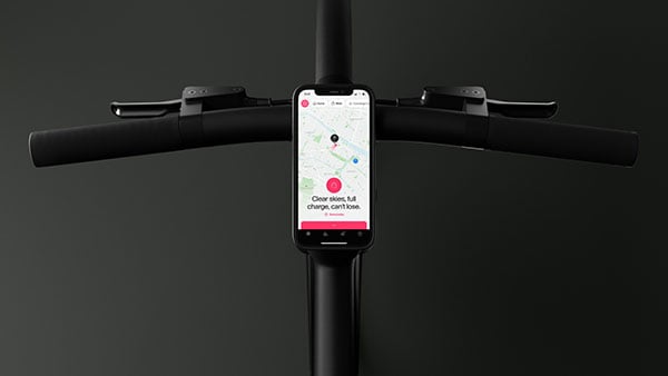
Photo: Cowboy

Photo: Cowboy

Taoglas and u-blox showcased their positioning solution for the Cowboy electric bike at Mobile World Congress Los Angeles 2021. taking place Oct. 26-28.

The Cowboy e-bike solution provides riders with high-performance, real-time GNSS accuracy, enabling them to map their own paths and those of the cities they live in.

The Cowboy e-bike uses smart road-companion applications to ensure riders get precise information, regardless of the route they travel. The positioning component uses Taoglas’ Accura GVLB258.A, a multi-band GNSS L1/L5, high-performance stacked patch antenna, in conjunction with u-blox’s SAM-M8Q GNSS positioning module. The combination allows for extremely low power and high accuracy.

The solutions works with “micromobility” services offered by Cowboy, such as Easy Rider for theft detection, bike insurance, and crash detection notifications.

Publicerad den Lämna en kommentar

Fugro delivers seabed geodata, employs wind lidar buoys

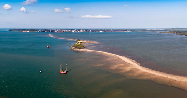
Fugro has completed a geotechnical site characterization project for DRA Global as part of the proposed expansion of the port of Richards Bay in South Africa.

Fugro’s self-elevating platforms being positioned in Richards Bay ready for their geotechnical site characterization for the planned port expansion. (Photo: Fugro)

Fugro’s self-elevating platforms being positioned in Richards Bay ready for their geotechnical site characterization for the planned port expansion. (Photo: Fugro)

DRA Global contracted Fugro to acquire critical seabed geodata required for the completion of preliminary engineering and design works. The project began with a cross-continental mobilization of marine assets from Bangladesh and UAE to Richards Bay and was safely delivered despite challenging ground conditions and ongoing COVID-19 restrictions.

The very soft soils encountered at depths of more than 40 meters below the seafloor required an innovative solution for positioning the two geotechnical drill rigs safely, so Fugro mobilized two bespoke modular self-elevating platforms (SEPs) to acquire high-quality geodata in a wide range of water depths. Their experienced staff, combined with adaptable marine assets and tooling, enabled Fugro to deliver DRA Global’s requirements in full and avoid any data gaps that could have led to an over-engineered design and ultimately higher construction costs.

“Fugro performed well under difficult circumstances, including challenging site conditions and intense focus on environmental management in sensitive areas, all while working in an operational port,” said Cobus Rossouw, principal marine engineer at DRA Global. “Their robust safety management systems resulted in an investigation completed without a single lost-time incident.”

Energinet contract for wind lidar measurements

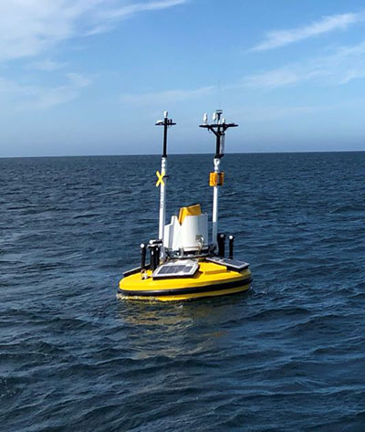
Fugro’s Seawatch lidar buoys will record continuous wind measurements to support wind-resource mapping for Denmark’s Energy Island development. (Photo: Fugro)

Fugro’s Seawatch lidar buoys will record continuous wind measurements to support wind-resource mapping for Denmark’s Energy Island development. (Photo: Fugro)

Fugro has secured a contract with Energinet to provide floating wind lidar measurements for what an offshore artificial energy island, which is being constructed for the Danish Government.

Fugro will install and operate four SEAWATCH wind lidar buoys at two locations, Energioe Nordsoen and Energioe Baltic, that will act as hubs connecting several offshore wind farms.

Starting this month October, the buoys will record continuous wind measurements for a minimum of one year to support wind-resource mapping for the two islands, and the engineering and design of the future wind farms. Fugro is already performing geophysical surveys for the Energy Island project under a separate contract to provide Energinet with a reliable de-risked site interpretation.

The SEAWATCH wind lidar buoy can record wind measurements up to 250 meters above sea level, and wave measurements and current profiles down to the seabed. The buoy also acts as a multipurpose platform for additional metocean sensors and, on this project, will be fitted with sensors to capture geodata on environmental impact parameters.

Contract for erosion off Indian coast

OCS Services Pvt. Ltd (OCS), one of India’s marine service providers, has awarded Fugro a two-year contract to support its asset integrity and corrosion management operations off the west coast of India.

Fugro will help OCS deliver on ONGC’s Protective Coating of Process Platform Project 1, an infrastructure project to maintain and refurbish 32 offshore platforms in seven clusters. The project is expected to be completed by May 2023.

Publicerad den Lämna en kommentar

Bad Elf Introduces laser offset workflow for Esri ArcGIS Field Maps

Photo: Bad Elf

Photo: Bad Elf

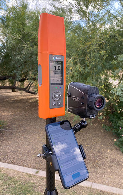
Bad Elf LLC and Laser Tech are providing an integrated laser offset workflow for acquiring high-accuracy field data in GNSS-challenged environments.

The new workflow integrates Bad Elf and LTI hardware in collaboration with ArcGIS technology from Esri.

The Bad Elf Flex GNSS receiver connects to any LTI TruPulse rangefinder over a wired or Bluetooth connection to deliver high-accuracy location data to Esri ArcGIS Field Maps. Field workers can now efficiently complete position and height data collection in access-limited situations, saving time, money and effort, the companies said.

“This collaborative integration effort empowers field data collectors to focus their time, energy, and budget on creating and maintaining their systems of record, instead of troubleshooting systems integration issues,” said Larry Fox, vice president of marketing and business development at Bad Elf. “As Esri Partners in the Esri Partner Network, we are pleased to collaborate with LTI in offering a straightforward workflow to our customers.”

“The ability to capture height measurements of an asset expands the data collection capabilities and ability to add more attribute data to the remote asset,” said Derrick Reish, senior product manager at Laser Tech.

Bad Elf’s app workflow focuses on enhancing productivity, reducing field collection difficulties, and mitigating quality issues. The Bad Elf app workflow runs on Android and iOS. Connection versatility minimizes operating system limitations and allows for app-based or standalone operation. Bad Elf also provides free Esri ArcGIS Desktop and ArcGIS Pro tools for offset-enabled point feature capture using the currently available ArcGIS Field Maps for iOS.

“The Bad Elf Flex, when paired with an LTI TruPulse rangefinder and ArcGIS Field Maps, delivers a powerful data collection solution,” said Esri Product Lead Jeff Shaner. “The innovative checklist-driven workflow delivers an intuitive, streamlined experience for advanced field workflows and the ability to provide a height calculation unlocks new opportunities for data capture.”

Publicerad den Lämna en kommentar

Swift Navigation honored with fleet management award

Swift Navigation logoSwift Navigation has been named Fleet Management Technology Company of the Year in the second annual AutoTech Breakthrough Awards conducted by AutoTech Breakthrough.

AutoTech Breakthrough is a market intelligence organization that recognizes the top companies, technologies and products in the global automotive and transportation technology markets.

Swift offers a highly-accurate, highly-reliable precise positioning solution that improves the operational efficiency of commercial transport, long-haul trucking and last-mile delivery, whether human-driven or autonomous. Swift’s fleet management precise positioning solution is comprised of the Skylark precise positioning service—delivering continent-wide, cloud-based corrections service — and the receiver-agnostic Starling positioning engine, which works with a variety of automotive-grade GNSS chipsets and inertial sensors, making centimeter-level GNSS accuracy a possibility without the cost of all new equipment.

Swift’s precise positioning solution delivers improved GNSS accuracy to make it easier to enable key fleet management capabilities such as lane-level analytics, route optimization and accurate traffic flow analytics to improve operational efficiency.

Publicerad den Lämna en kommentar

Sandia Labs shows GPS-free quantum-based wayfinding device

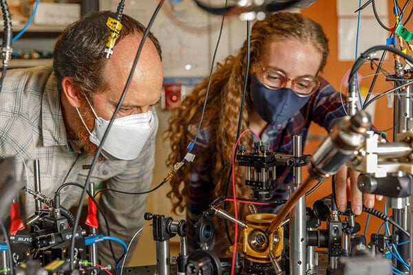
Sandia National Laboratories scientist Peter Schwindt, left, and postdoctoral scientist Bethany Little examine the vacuum package held in a yellow, 3D-printed mount. (Photo: Bret Latter/Sandia) 

Sandia National Laboratories scientist Peter Schwindt, left, and postdoctoral scientist Bethany Little examine the vacuum package held in a yellow, 3D-printed mount. (Photo: Bret Latter/Sandia)

The compact, fieldable device could provide means to navigating without GPS

News from Sandia National Laboratory

Don’t let the titanium metal walls or the sapphire windows fool you. It’s what’s on the inside of this small, curious device that could someday kick off a new era of navigation.

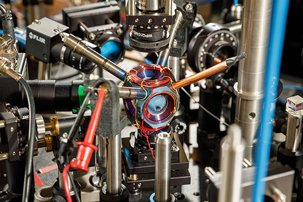
For more than a year, the avocado-sized vacuum chamber has contained a cloud of atoms at the right conditions for precise navigational measurements. It is the first device that is small, energy-efficient and reliable enough to potentially move quantum sensors — sensors that use quantum mechanics to outperform conventional technologies — from the lab into commercial use, said Sandia National Laboratories scientist Peter Schwindt.

Sandia developed the chamber as a core technology for future navigation systems that don’t rely on GPS satellites, he said. It was described earlier this year in the journal AVS Quantum Science.

Countless devices around the world use GPS for wayfinding. It’s possible because atomic clocks, which are known for extremely accurate timekeeping, hold the network of satellites perfectly in sync.

But GPS signals can be jammed or spoofed, potentially disabling navigation systems on commercial and military vehicles alike, Schwindt said.

Instead of relying on satellites, Schwindt said future vehicles might keep track of their own position. They could do that with onboard devices as accurate as atomic clocks, but that measure acceleration and rotation by shining lasers into small clouds of rubidium gas like the one Sandia has contained.

Atomic accelerometers and gyroscopes already exist, but they’re too bulky and power-hungry to use in an airplane’s navigation system. That’s because they need a large vacuum system to work, one that needs thousands of volts of electricity.

A compact device designed and built at Sandia National Laboratories could become a pivotal component of next-generation navigation systems. (Photo: Bret Latter/Sandia)

A compact device designed and built at Sandia National Laboratories could become a pivotal component of next-generation navigation systems. (Photo: Bret Latter/Sandia)

“Quantum sensors are a growing field, and there are lots of applications you can demonstrate in the lab,” said Sandia postdoctoral scientist Bethany Little, who is contributing to the research. “But when you move it into the real world, there are lots of problems you have to solve. Two are making the sensor compact and rugged. The physics takes place all in a cubic centimeter (0.06 cubic inches) of volume, so anything larger than that is wasted space.”

Little said her team has shown that quantum sensing can work without a high-powered vacuum system. This shrinks the package to a practical size without sacrificing reliability.

Instead of a powered vacuum pump, which whisks away molecules that leak in and wreck measurements, a pair of devices called getters use chemical reactions to bind intruders. The getters are each about the size of a pencil eraser so they can be tucked inside two narrow tubes sticking out of the titanium package. They also work without a power source.

To further keep out contaminants, Schwindt partnered with Sandia materials scientists to build the chamber out of titanium and sapphire. These materials are especially good at blocking out gasses like helium, which can squeeze through stainless steel and Pyrex glass. Funding was provided by Sandia’s Laboratory Directed Research and Development program.

Construction took sophisticated fabrication techniques that Sandia has honed to bond advanced materials for nuclear weapons components. And like a nuclear weapon, the titanium chamber must work reliably for years.

The Sandia team is continuing to monitor the device. Their goal is to keep it sealed and operational for five years, an important milestone toward showing the technology is ready to be fielded. In the meantime, they’re exploring ways to streamline manufacturing.

Sandia National Laboratories is a multimission laboratory operated by National Technology and Engineering Solutions of Sandia LLC, a wholly owned subsidiary of Honeywell International Inc., for the U.S. Department of Energy’s National Nuclear Security Administration. Sandia Labs has major research and development responsibilities in nuclear deterrence, global security, defense, energy technologies and economic competitiveness, with main facilities in Albuquerque, New Mexico, and Livermore, California.