Publicerad den Lämna en kommentar

Launchpad: Nano drone, GNSS modules, survey application

A roundup of recent products in the GNSS and inertial positioning industry from the October 2022 issue of GPS World magazine.


OEM

Software

Aids GNSS/INS installation

Photo: Septentrio

Photo: Septentrio

The RxLeverArm software tool aids integration of GNSS receivers that include inertial navigation systems (GNSS/INS). RxLeverArm is part of Septentrio’s RxTools software package included with every Septentrio GNSS/INS receiver. The new tool visualizes, validates and automatically calibrates the exact distance between the INS sensor and the antenna, removing the need for accurate distance measurements with complex instruments. For lever-arm compensation, users only need to measure the rough distance between the INS sensor and the main GNSS antenna reference points on the vehicle. Data is then logged under open-sky conditions, which allows the RxLeverArm tool to optimize the initial rough distance measurement and prevent common errors such as sign inversion.

Septentrio, septentrio.com

Testing Board

Enables proof of concept for IoT products and applications

Photo: u-blox

Photo: u-blox

The u-blox XPLR-IOT-1 IoT explorer kit is an all-in-one package to test, evaluate and validate applications for the internet of things (IoT). The board hosts an ultra-low-power MAX-M10S positioning module capable of concurrently tracking four GNSS constellations, delivering highly reliable location data. Integrating relevant u-blox technologies and services into a capable prototyping platform with a vast selection of sensors and interfaces as well as cloud connectivity, XPLR-IOT-1 makes it easier to explore the potential of IoT applications.

u-blox, u-blox.com

GNSS Module

With RTK and dead reckoning

Photo: Quectel

Photo: Quectel

The LC29H is a dual-band multi-constellation GNSS module built using the Airoha AG3335 platform. It is available in multiple variants and optionally integrates real-time kinematic (RTK) and dead reckoning. The LC29H series offers high performance with power efficiency to meet the market needs of high-precision positioning at the centimeter and decimeter levels. The LC29H concurrently receives and processes signals from GPS, GLONASS, BeiDou, Galileo and QZSS. The modules are suited to an expanding market for autonomous lawn mowers, drones, precision agriculture, micro-mobility scooters and delivery robots.

Quectel Wireless Solutions, quectel.com

LoRa/GNSS Board

Equipped with u-blox tracking module

Photo: Move-X

Photo: Move-X

The Cicerone LoRa/GNSS board is a high-performance, low-power, Arduino MKR-compatible development board based on the u-blox MAX-M10S GNSS module and the MAMWLE LoRa module. It delivers high-performance GNSS, long-range wireless connection, and high-performance processing in a low-power solution for optimal battery life. The board allows users to build tracking applications worldwide with meter-level accuracy and to communicate long-range, low-power data via LoRaWAN. The integrated Li-Po charging circuit enables the Cicerone board to manage battery charging through the USB port. It has a compact 63 mm x 25 mm form factor and is compatible with all Arduino MKR shield boards. These boards all share a common pinout to enable developers to easily add expansions with minimal software changes.

Move-X, move-x.it

GNSS Module

New platforms improve positioning for wearables

Photo: Qualcomm

Photo: Qualcomm

The Snapdragon W5 Gen 1 and W5+ Gen 1 platforms are designed to advance ultra-low power and breakthrough performance for next-generation connected wearables with a focus on extended battery life and premium user experiences. They incorporate innovations including low power islands for GNSS, Wi-Fi and audio; ultra-low power Bluetooth 5.3 architecture; and low power states such as Deep Sleep and Hibernate. New enhancements to the flagship Snapdragon W5+ platform offer 50% lower power, 2x higher performance, 2x richer features, and 30% smaller size, compared to the previous generation. The purpose-built platform is comprised of a 4 nm-based system-on-chip and 22 nm-based highly integrated always-on co-processor. By using these platforms, manufacturers can scale, differentiate and develop products faster in the continuously growing and segmenting wearables industry, Qualcomm said. Qualcomm also announced two reference designs from Compal and Pegatron, which showcase the capabilities of the platform and the company’s collaboration with ecosystem partners, helping customers develop products faster.

Qualcomm Technologies, qualcomm.com


SURVEYING

GNSS Receiver

Dual cameras enable vision RTK surveying

Photo: Hi-Target

Photo: Hi-Target

The pocket-sized vRTK GNSS real-time-kinematic (RTK) receiver is equipped with dual cameras to enable non-contact image surveying. It also has a nine-axis IMU module with auto installation for tilt surveying. Visual positioning technology combines imagery with high-precision positioning equipment, allowing users to obtain the location of the target from a distance. The Live View Stakeout function improves stakeout speed, while non-contact measurement greatly improves the usable range of GNSS. The vRTK receives 1,408 channels (GPS, GLONASS, BeiDou, Galileo, QZSS, IRNSS and SBAS). A new generation of GNSS engine supports the new frequency points B1C, B2a and B2b RTK decoding of BeiDou-3 satellites.

Hi-Target, en.hi-target.com.cn

Compact Receiver

Smart antenna for field work
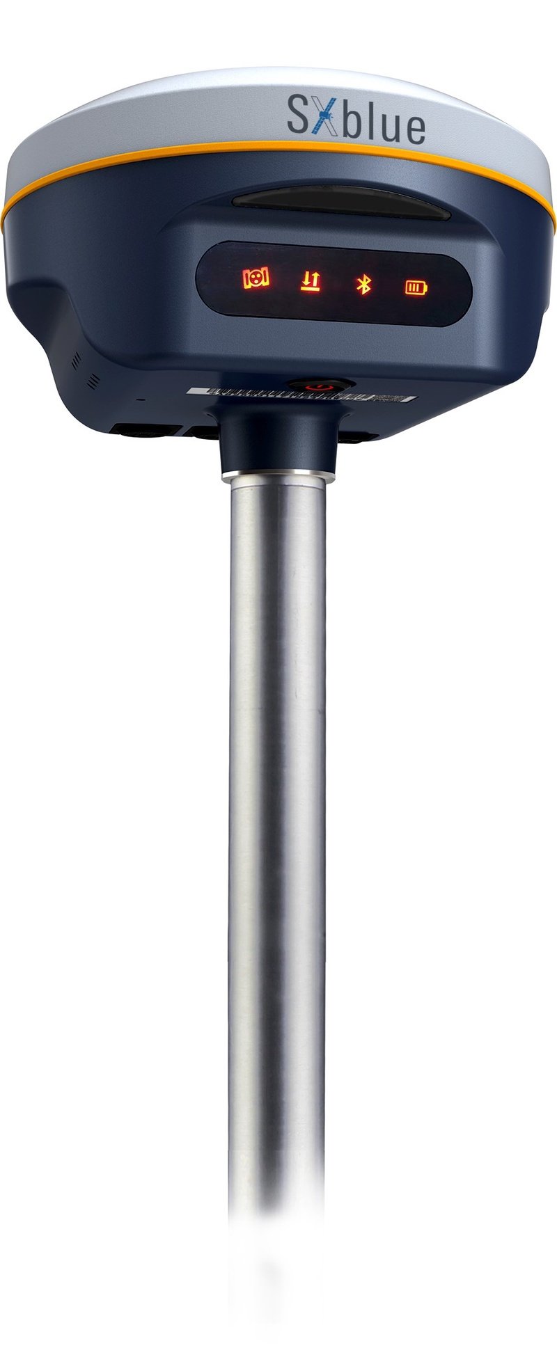
Photo: Geneq

Photo: Geneq

The SXblue SMART features an engine capable of tracking all-in-view GNSS signals, with interference mitigation and optimization for handling a wide frequency band. Weighing 850 g including battery, the SXblue SMART is compact and rugged. Its radio link is based on the Farlink protocol that allows a range of up to 8 km while reserving a wide bandwidth for transmission of real-time kinematic (RTK) data. In addition to a tilt sensor for measurements in hard-to-reach places, the SXblue SMART features a high-performance attitude measurement module that can detect and measure movement of the device. Also integrated are an inertial measurement unit and a thermometer for monitoring and controlling its internal temperature.

Geneq, geneq.com

Post-processing

For Windows and Mac users

Photo: Emlid

Photo: Emlid

Emlid Studio is a new post-processed kinematic (PPK) application designed specifically for post-processing GNSS data. It allows users to convert raw GNSS logs into RINEX, post-process static and kinematic data, geotag images from drones (including DJI brand), and extract points from survey projects completed with Emlid’s ReachView 3 app. With Emlid Studio, users can post-process data recorded with Emlid Reach receivers and other GNSS receivers or NTRIP services. Post-processing requires RINEX observation and navigation files. Raw data in UBX and RTCM3 format also can be used through conversion.

Emlid, emlid.com

GNSS Receiver

Integrated receiver and antenna for portability

Photo: SingularXYZ

Photo: SingularXYZ

The P1 GNSS receiver has a high-precision module that tracks GPS, GLONASS, BDS, Galileo, QZSS and SBAS to deliver centimeter-level real-time kinematic (RTK) accuracy even in harsh environments. It is also equipped with an anti-jamming and anti-spoofing algorithm. The P1 GNSS receiver has integrated the GNSS module and GNSS antenna while keeping the device as small as a smartphone, which makes it portable enough to be worn around the neck or placed in a pocket. With 4G/Bluetooth communication, the P1 supports real-time positioning data transmission, providing users with a stable correction data steam and positioning data uploads. The P1 also can be mounted on a pole.

SingularXYZ, singularxyz.com

Smartphone App

Updates include vector map import

Photo: Tersus GNSS

Photo: Tersus GNSS

Nuwa surveying smartphone app version 2.3.3.2 has vector map import and digital surface stakeout. The Nuwa app runs on Android and is reliable and easy to operate. It has rich and powerful functions that can help surveyors complete measurements more efficiently and accurately. The app is designed to work with the David and Oscar GNSS receivers from Tersus GNSS, plus other receivers that support NMEA-0183. Features include the ability to configure base, rover and static surveys; graphical interface with background map (online/import); CAD stakeout, road stakeout and earthwork; data management (import/export multiple formats); and Bluetooth and USB connection support.

Tersus GNSS, tersus-gnss.com

Survey Application

Now supports Web Maps and multi-part geometries

Photo: 1Spatial

Photo: 1Spatial

Version 3.2 of the survey application 1Edit allows the use of Web Maps (WMS) to be used as background layers, making it easier for surveyors to identify assets and changes in context. It provides easier configuration of background maps and supports hybrid working practices for surveyors. Where offline background maps are required, 1Edit supports multiple raster files and handles large image files, providing visual context for geospatial data when there is no data signal. Enhanced support for complex geometries increases efficiency as features with multiple parts share common attributes and IDs.

1Spatial, 1spatial.com


MAPPING

US Address Plug-In

Provides geocoding accuracy of 95%

Photo: Smarty

Photo: Smarty

The Smarty U.S. Geocoding QGIS Plugin provides an easy way for users of the software platform to validate, standardize, and convert addresses to their latitude and longitude coordinates (geocodes). The plugin allows manual address entry as well as batch geocoding via CSV. It features a 95% match rate with the actual rooftop and parcel, as well as providing sub-address geocoding that can match secondary addresses such as apartment units and office-suite rooftops in building. The free plugin also includes supplemental metadata useful for many geographic information system (GIS) purposes.

Smarty, smarty.com

GIS Location Data

Datasets for the United States, UK, Canada, Australia and Europe

Photo: Maptitude

Photo: Maptitude

Maptitude 2022 is a major release of the geographic information system (GIS) and mapping software. It includes up-to-date, accurate data encompassing expenditure, geodemographic segments, gross domestic product, medical and banking locations, branded business locations, traffic counts, building footprints, address points and financial assets, as well as the tools to leverage this information to improve the location intelligence of organizations in markets such as healthcare, franchising, communications, logistics, retail, real estate and banking.

Maptitude, maptitude.com

Rugged Tablet

For mapping and data collection

Photo: Juniper Systems

Photo: Juniper Systems

The Mesa Pro rugged tablet features 11th-generation Intel Core processors, a Windows 11 operating system, device customization options, a large sunlight-readable display and the “Juniper Rugged” company design. Standard Mesa Pro units come with an 11th Gen Intel Core i5 processor and 16 GB of LPDDR4x RAM. Core i7 and Celeron versions are also available. Each Mesa Pro configuration offers powerful performance and allows users to select the computing performance that fits their needs and budgets.

Juniper Systems, junipersys.com


AUTONOMOUS

Airspace Management

Data fusion across multiple data sources, including ADS-B

Photo: Vigilant Aerospace

Photo: Vigilant Aerospace

FlightHorizon COMMANDER is a situational awareness and safety system for UAV airspace management. The system provides airspace managers with either a 2D or 3D view of all aircraft in the selected airspace using a combination of sensors and data sources to create an airspace safety picture for pilots, airspace managers and command centers. The system is based on an exclusively licensed NASA patent and prototype that has been used in extensive flight testing. FlightHorizon COMMANDER functions as a visualization tool for airspace management, an active situational awareness tool, and a detect-and-avoid system that enables unmanned aircraft to avoid other aircraft and keeps drone pilots and airspace managers aware of the location and air traffic around their UAS and in their airspace.

Vigilant Aerospace, vigilantaerospace.com

Heavy Lift Drone

Supports both automated and manual operations

Photo: Draganfly

Photo: Draganfly

The Draganfly Heavy Lift Drone is a versatile, multi-rotor unmanned aerial vehicle designed to enhance deliveries and flight times. Compatible with a variety of interchangeable payloads, the heavy-duty drone can carry more and fly longer than the typical professional drone. It has a payload/cargo-lift capacity of 30 kg (67 lbs) and up to 55 minutes of flight time. The industrial UAV handles heavy winds and high elevations with ease. Its lifting capacity permits flexibility in carrying large high-end sensors such as hyperspectral and bathymetric lidar to conduct large-area surveys.

Draganfly, draganfly.com

Infrared Camera Module

Allows rapid MWIR integration for commercial, industrial and defense applications

Photo: Teledyne FLIR

Photo: Teledyne FLIR

Part of the Neutrino IS series, the Neutrino LC CZ 15-300 is a new mid-wavelength infrared (MWIR) camera module with integrated continuous zoom lenses. Designed for integrated solutions requiring crisp, long-range MWIR imaging, the camera offers size, weight, power and cost (SWaP+C) benefits to original equipment manufacturers (OEMs) and system integrators for airborne, unmanned, C-UAS, security and targeting applications. The LC CZ 15-300 offers high performance, 640 x 512 high-definition MWIR imagery and 15 mm to 300 mm zoom capability for ruggedized products requiring long life, low power consumption and quiet, low-vibration operation. The camera module and lens are designed for each other, providing optimal performance.

Teledyne FLIR, flir.com

Nano Drone

Flies like a hummingbird
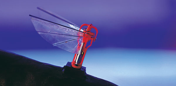
Photo: Aselsan

Photo: Aselsan

A miniature drone with flapping wings was demonstrated at the Teknofest Black Sea aviation and defense industry event, which took place Aug. 30 to Sept. 4 at the Samsun Çarşamba Airport. With its low detectability, the nano drone is being developed to perform reconnaissance and surveillance missions. It is still in research and development.

Aselsan, aselsan.com.tr


TRANSPORTATION

Lidar Transceiver

Enables machine vision at highway speeds

Photo: SiLC Technologies

Photo: SiLC Technologies

The Eyeonic Vision Sensor can perceive, identify and avoid objects at a range of more than 1 kilometer. The sensor is a frequency modulated continuous wave (FMCW) lidar transceiver that uses a silicon photonic chip. Long-range visibility is a requirement for autonomous vehicles, which require sufficient awareness to evade obstacles at highway speeds. This capability requires vision sensors to provide millimeter-level accuracy and depth at instantaneous velocity. The highly detailed and ultra-long-range information from the Eyeonic Vision Sensor enables robots to classify and predict their environments. The sensor is designed to be integrated into autonomous vehicles, security solutions and industrial robots.

SiLC Technologies, silc.com

Vehicle Computer

For fully connected buses, trucks and trains

Photo: Nexcom

Photo: Nexcom

The nROK 1030 is a compact, rugged entry-level vehicle computer with an advanced GNSS receiver. The u-blox NEO-M9N module supports GPS, GLONASS, Galileo, BeiDou and QZSS signals. An Intel Atom x6211E dual-core processor 1.3 GHz/3 GHz (burst) is designed for harsh in-train environments. Its fanless, compact design is suitable for vehicles with limited space. The nROK 1030 has onboard CAN 2.0B for vehicle diagnostics and driver behavior management. WLAN Wi-Fi 6/6E/Wi-Fi 5 and WWAN 5G NR/LTE wireless data connectivity is optional. The nROK 1030 is flexible to meet the demands of various rolling-stock applications, such as wireless gateway, infotainment and digital radio data/voice transmission systems.

Nexcom, nexcom.com

Publicerad den Lämna en kommentar

TOPODRONE introduces bathymetric surveying device

TOPODRONE, a Swiss-based designer and manufacturer of high-precision lidar equipment for installation on drones, vehicles and backpacks, launched AQUAMAPPER, a UAV-based solution for bathymetric surveying and marine construction.

AQUAMAPPER contributes to a complete set of photogrammetry, Lidar and bathymetry surveying solutions from TOPODRONE. The product, compatible with the DJI Matrice 300 RTK, provides a combination of high-speed efficiency (up to 14 km/h) and accuracy mounted on a UAV. The application areas include an open sea bathymetric survey up to 100m depth, quantity survey and calculation of sediments and periodic maintenance survey of storage pools.

Photo: Topodrone

Photo: TOPODRONE

The new data-collecting device has been successfully used alongside TOPODRONE’s LiDAR ULTRA equipment for airborne surveying at a highway construction project in one of the toughest terrains in Romania, EU, including 7 tunnels, 24 bridges and 18 viaducts. The project was performed by the Romanian company GRAPHEIN TOPO SA to deliver a full digital twin of a studied area.

Photo: Topodrone

Photo: TOPODRONE

The TOPODRONE LiDAR ULTRA on board a DJI M300 drone was used to capture laser scanning data from 100 – 120 meters altitude over rugged terrain forest area to cover a corridor 32 km long and 400 meters wide in 14 flights while AQUAMAPPER connected to the same DJI M300 drone performed bathymetry survey over six river crossings.

“The key advantage of the new bathymetric equipment from TOPODRONE is the ability to capture a riverbed with centimeter-level accuracy with high speed in fully automatic mode and without using any boat,” said Andrei Sueran of GRAPHIEN TOPO SA. “The combination of an echosounder, GNSS and inertial measurement system helps to get accurate results after data post-processing.”

Publicerad den Lämna en kommentar

Estonia confiscates drones for Russia, sends them to Ukraine

Plus: Visual AI radar aids drone searches, and a drone is released into Hurricane Ian

Just when you imagine there couldn’t be any more twists and turns to the war in Ukraine, another one turns up. Some may recall that Estonian security forces caught an Estonian/Russian man trying to send drones to Russia. The Estonian government confiscated the shipment of DJI drones.

Now Estonia has donated those drones to Ukraine for use against Russia in the ongoing war.

Some might say that this is an example of, “What comes around goes around.” Nevertheless, everyone respects Russia’s nuclear options…

Making Drones Smart

It’s all well and good that we have all shapes and sizes of battery- and gas-powered drones, ones that take off and land vertically (eVTOL) or horizontally (generally, fixed-wing). But how do we make them smart enough to complete tasks on their own?

Artificial intelligence (AI) could be the answer. Take the Boeing Loyal Wingman drone. It is being developed to fly autonomously alongside high-end fighters, and  perhaps to control other drones flying nearby. Those tasks require AI, which is being incorporated into the capabilities of drone systems.

We also have immediate needs, such as search and rescue, security patrol and inspection (for commercial and military facilities, border and crowd control) and military intelligence, surveillance, target acquisition and reconnaissance (ISR/ISTAR). Along comes Sentient Vision Systems of Australia with a passive, software-based “visual radar” solution.

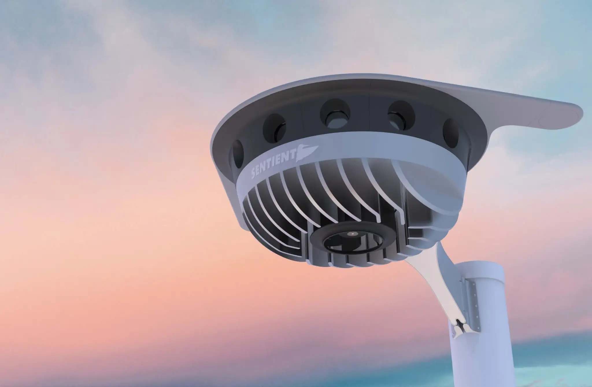
Sentient Vision Systems uses its digital AI processing with existing visual and infrared sensors. This combination can apparently surpass human and conventional radar capability to detect and track small moving objects.

Search and rescue at sea can be a really difficult task for people. It’s not surprising that a lot of lengthy searches end up with zilch. During a search, an aircraft flies from 20,000 feet down to 500 feet over the waves. If you have seen cabin video of air-sea searches in progress, with a searcher gazing out of the aircraft’s window for hours, straining to see something small bobbing in the sea below, it does seem like a herculean task.

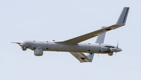
As an alternative, take a long-range (>55 nautical miles) drone, such as a Boeing/Insitu ScanEagle. Hook up the scanning search camera and high-resolution nose turret to the vidar (visual detection and ranging) processing.

Boeing/Insitu ScanEagle UAV with vidar pod. (Photo: Insitu)

Boeing/Insitu ScanEagle UAV with vidar pod. (Photo: Insitu)

As a result, you have an autonomous airborne system that can find a person in the water from a distance of about 1.7 nautical miles, and spot a ferry deck from ~30 nautical miles. Insitu claims that conventional radar systems cannot do this. In 12 hours it can search an area of about 13,400 square nautical miles.

Sentient's AI-enabled Vidar Surface sensor. (Photo: Sentient)

Sentient’s AI-enabled Vidar Surface sensor. (Photo: Sentient)

Several such sorties might just have found an early trace of Malaysian Airlines Flight MH370 in 2014. The Boeing 777 with 239 people on board disappeared over the South China Sea 38 minutes after takeoff on a flight to Beijing. Over three years, long-range patrol aircraft covered 46,000 square miles before the search was abandoned.

During 2015 and 2016, pieces of the airplane began washing up on the shores of countries on the Western Indian Ocean. The search would probably not have been easy even for a fleet of ScanEagles, considering the logistics and the available range of the unmanned aircraft, but major incidents might find success with vidar-equipped UAVs.

Into the Eye of the Hurricane

The devastation that Hurricane Ian wrought in Southwest Florida has been terrible. A shark swimming up a street in Fort Meyers illustrates the degree of flooding left from landfall of the category 4-5 hurricane.

Ian was the strongest hurricane to make landfall in the United States in decades, with extremely high winds and strong storm surge. I sat through the storm 75 miles to the North, and it was one scary hurricane even there. I can’t sympathize enough with the residents of Lee County, who only received a warning to evacuate one day before it hit them.

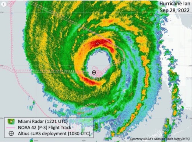
Nevertheless, the National Oceanic and Atmospheric Administration (NOAA) had its Hurricane Hunter Orion aircraft up to investigate on Sep. 28 as the storm came in from the Caribbean. Despite bad turbulence, the P-3 aircraft flew into the upper regions of the Hurricane and launched an Altus-600 27-pound drone into the eye at 4,500 feet. With a 275-mile range at up to 100 mph, the aircraft crew controlled the small drone, using it to collect data on wind speed, pressure, temperature and humidity.

The Orion P-3D Hurricane Hunter aircraft and the Altus-600 drone. (Photo: NOAA)

The Orion P-3D Hurricane Hunter aircraft and the Altus-600 drone. (Photo: NOAA)

During the two-hour mission, the Altus drone flew into the eye wall, where winds of 187 mph were detected at altitudes between 2,300 and 200 feet. It’s not exactly clear whether the drone survived.

This radar image of Hurricane Ian shows the Altus release point. (Image: NOAA)

This radar image of Hurricane Ian shows the Altus release point. (Image: NOAA)

While information gathered may have assisted with the immediate forecasting for us Florida folks on the ground, the real scientific value comes from feeding the data into National Hurricane Center models for storm detection and analysis to keep us safer in the future.

Wrap up

To sum up, this month we saw drones destined for Russia sent to Ukrainian forces. Vidar artificial intelligence on Insitu ScanEagle drones promises huge gains for search and rescue. And, once again, a NOAA crew flew directly into the eye of a hurricane, this time releasing a drone to aid in gathering essential storm data.

Tony Murfin
GNSS Aerospace

Publicerad den Lämna en kommentar

How navigation data is used for video game development

The realistic racetrack in the Assetto Corsa game. (Screenshot: Dronezone)

The realistic racetrack in the Assetto Corsa game. (Screenshot: Dronezone)

News from OxTS

The possible applications for 3D point clouds are almost endless. When you think of lidar, the mind naturally wanders to applications of the autonomous vehicle navigation or geospatial survey type. In fact, navigation and lidar data are useful for all manner of applications—including video game development.

When a new technology, such as lidar, is first brought to market, a number of factors affect its price. Initially, the cost-per-unit is likely to be high to ensure recovery of research and development costs. However, as technology ages and manufacturers innovate and bring out new versions, price invariably comes down.

As this process occurs, it puts the technology into the hands of a much wider audience, increasing the number of new and innovative use cases.

Point clouds are useful for many wide and varied applications. Autonomous vehicle developers may use point clouds to aid object detection and avoidance, while geospatial surveyors could use a point cloud to determine road degradation over time or monitor the rate of coastal erosion.

These are however some of the more common use cases. But how can navigation data be used in applications such as video game development? Let’s first look at how navigation data works alongside lidar.

Lidar and Inertial Navigation

To create a 3D point cloud, users must combine the position, navigation and timing measurements from an inertial navigation system (INS) with raw lidar data. Without accurate INS data, it is impossible to create a point cloud. This is because the lidar sensor needs to know its position in space and time and its orientation.

To avoid complicated software engineering work, simple-to-use software such as OxTS Georeferencer is available to georeference the lidar data. Once georeferencing is complete, OxTS Georeferencer will create a PCAP file that users can view in many point cloud viewer software applications.

Enter Dronezone

As lidar technology becomes more accessible, new and inventive ways to use point clouds are coming to light. OxTS partner Dronezone is one such company finding new uses for lidar.

Dronezone builds and hires out professional unmanned aerial vehicles (UAVs). They build UAV payloads with Velodyne VLP-16 lidar sensors and OxTS INS devices they sell or rent to customers.

Cover: Kunos Simulazioni

Cover: Kunos Simulazioni

Dronezone’s customers have used the payloads for a variety of projects. One used a payload to scan an aging railway bridge looking for possible weaknesses and deterioration over time. Besides geospatial mapping projects, Dronezone is seeing an increasing need to cater to niche applications.

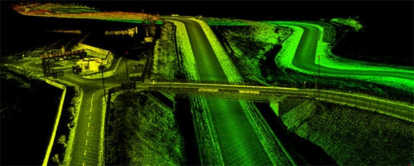
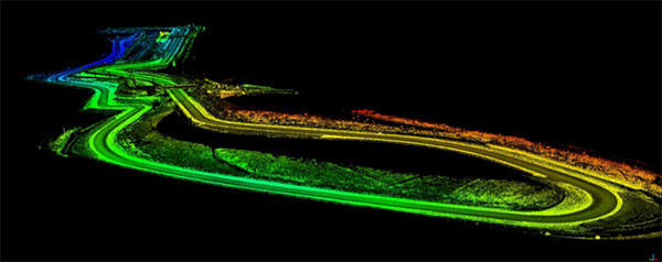
Dronezone undertook surveying the Transylvania Motor Ring racetrack for a video-game developer Kunos Simulazioni, which publishes racing simulator “Assetto Corsa.” The company wanted an accurate digital representation of the track contours. The results, which you can see in the video and screenshots, are particularly impressive.

Point cloud of the Transylvania Motor Ring. (Image: Dronezone)

Point cloud of the Transylvania Motor Ring. (Image: Dronezone)

Point cloud of the Transylvania Motor Ring. (Image: Dronezone)

Point cloud of the Transylvania Motor Ring. (Image: Dronezone)

Racing Simulator

For this project, Dronezone moved away from traditional UAV-based mapping. To survey the track precisely, the company used the flexibility of its UAV payload by repurposing the hardware for use on a car. With many off-the-shelf solutions, this wouldn’t have been possible. The setup enabled Dronezone to complete multiple laps of the track and create a high-density point cloud.

“Using different components to build a UAV payload meant that Dronezone could reuse the hardware and build a different setup suitable for use on a car,” said Paris Austin, head of new product technology, OxTS. “It’s this flexibility that allows Dronezone to serve multiple applications.”

To further improve results, Dronezone used the Boresight Calibration feature within OxTS Georeferencer to calibrate the coordinate frames of the lidar sensor and INS. This process, which involves a short survey of two retro-reflective targets, increases the clarity of the final results and eliminates blurring and double vision.

The OxTS INS and lidar payload on an auto for racetrack mapping. (Photo: Dronezone)

The OxTS INS and lidar payload on an auto for racetrack mapping. (Photo: Dronezone)

The quality of the data produced has given Dronezone confidence it can win more business from the same customer to map further tracks for the game.

This is just one example of the new and unique applications we’re developing alongside our customers.


The original article appears on the OxTS website.

Publicerad den Lämna en kommentar

Australia’s SouthPAN early Open Services now live

Early Open Services delivered by the Southern Positioning Augmentation Network (SouthPAN) are now live in Australia and New Zealand, improving location-based capabilities for the Australasia region.

SouthPAN provides accurate, reliable and instant positioning services across all of Australia and New Zealand’s land and maritime zones without the need for mobile phone or internet coverage. It will improve positioning from 5-10 meters, to as little as 10 centimeters — a 50-fold increase in accuracy.

The SouthPAN satellite-based augmentation system (SBAS) test-bed project took place between 2017 and 2019, demonstrating the value of SouthPAN to Australian and New Zealand economies and communities. Economic analysis indicates that it is more than $6.2 billion for Australia alone.

In February 2020, Geoscience Australia and Toitū Te Whenua Land Information New Zealand (LINZ) began a joint collaboration on SouthPAN under the Australia New Zealand Science, Research and Innovation Cooperation Agreement (ANZSRICA). A comprehensive procurement process followed, awarding an AUD$1.18 billion, 19-year contract on Sept. 16 to Lockheed Martin Australia.

“The SouthPAN project team will work with Lockheed Martin Australia to establish a network of Global Navigation Satellite System reference stations, a corrections processing facility and satellite uplink facilities that will enable accurate and reliable positioning signals to be transmitted from satellites to users,” said Madeleine King, Minister for Resources and Northern Australia. “The SouthPAN services will be fully operational across the two countries with safety-of-life certification from 2028.”

Benefits from SouthPAN

With early Open Services, Geoscience Australia and Toitū Te Whenua Land Information New Zealand enable industry access to SouthPAN. Early Open Services can immediately integrate with existing equipment or products, to create or enhance positioning service offerings to end-users.

Early Open Services will bring widespread benefits across agriculture, construction, resources and many other industries, paving the way for technological advancements in automation, including:

  • heavy vehicle automation, such as truck platooning, where vehicles can connect to each other as a group to transport goods
  • precision agriculture applications such as yield mapping, controlled traffic farming, inter-row seeding, precision spraying and livestock management
  • personnel safety on mine and construction sites, through smart geofencing technologies that accurately identify the locations of workers with key equipment, such as vehicles and heavy machinery.

SouthPAN is estimated to generate more than AUD$6 billion in benefits to the Australian economy over the next 30 years.

King said the new network will allow

  • mining companies to install more accurate collision avoidance systems on automated mining haul trucks
  • visually impaired citizens to navigate cities with pinpoint assistive technologies
  • light aircraft to land more safely in remote rural areas in all weather conditions, including essential services such as The Royal Flying Doctor Service.

The joint Australia-New Zealand initiative will be a game-changer for the economies of both nations, said Damien O’Connor, New Zealand minister for land information.

“This technology was originally developed to support aviation safety, but as technology has advanced, the applications have expanded,” O’Connor said. “It now has potential uses as varied as enabling accurate vehicle guidance for efficiencies in agriculture and horticulture management, tracking maritime shipments, and enabling navigation for drones and other unmanned vehicles.”

Early Open Services

SouthPAN will provide three early Open Services.

L1 SBAS Open Service. The L1 SBAS early Open Service will provide navigation messages on the L1 frequency (1,575.42 MHz), and allow users with a receiver that tracks GPS L1 C/A signals to improve their position accuracy to better than ≤3m in the horizontal and ≤4 m in the vertical (95% confidence interval).

DFMC SBAS Open Service. The Dual-Frequency Multi-Constellation SBAS early Open Service will provide navigation messages on the L5 frequency (1,176.45 MHz), and allow users — with a receiver that tracks GPS L1 C/A and L5 signals, and Galileo E1 and E5a signals — to improve their position accuracy to better than ≤1.5m in the horizontal and ≤2.5 m in the vertical (95% confidence interval).

PVS Open Service. The Precise Point Positioning (PPP) via SouthPAN (PVS) early Open Service will share the L5 frequency with the DFMC SBAS Open Service in the near future, before transitioning to a new navigation signal. PVS will allow users — with a receiver that tracks GPS L1 C/A and L5 signals and Galileo E1 and E5a signals, and is capable of processing the PVS messages — to improve their position accuracy better than ≤0.40 m in the horizontal and ≤0.55 m in the vertical (95% confidence interval) after convergence. Convergence will be better than 80 minutes during PVS early Open Services, and the user does not need to remain stationary during the convergence period.

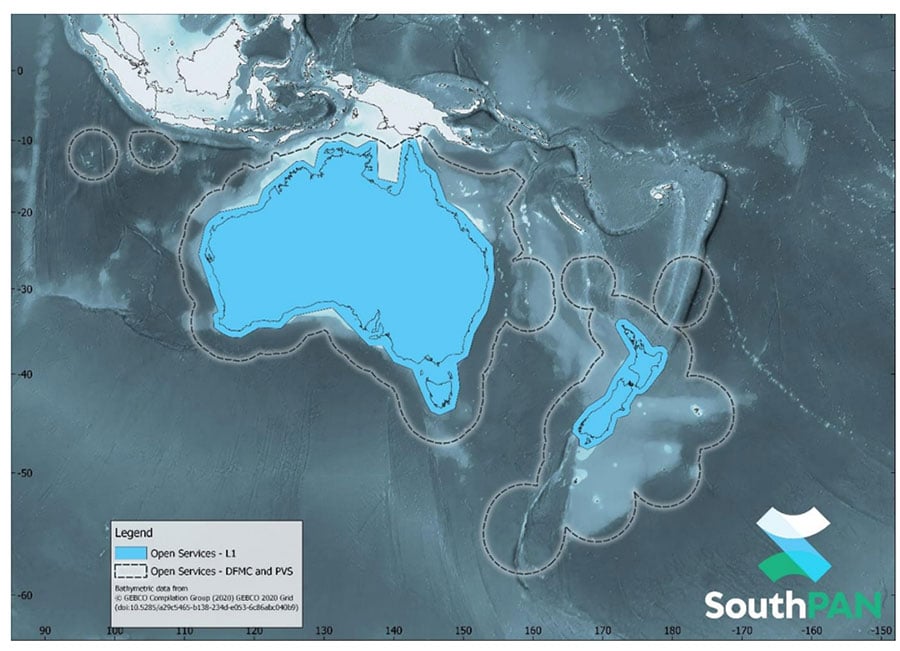
SouthPAN early Open Services coverage. OS-L1 covers mainland Australia and New Zealand. OS-DFMC and OS-PVS cover Exclusive Economic Zones in both countries. (Image: Geosciences Australia)

SouthPAN early Open Services coverage. OS-L1 covers mainland Australia and New Zealand. OS-DFMC and OS-PVS cover Exclusive Economic Zones in both countries. (Image: Geosciences Australia)

More information is available in the SouthPAN Open Services factsheet for end-users and in the SouthPAN Service Definition Document (SDD) and Disclaimer.

How SouthPAN works

SouthPAN uses several distributed ground stations to monitor signals broadcast by GNSS satellites, and compares each station’s known location with position data from the satellites.

The GNSS signal data and measurement information is sent to correction processing facilities. The facilities aggregate the data from all ground stations, produce error corrections and status information about the GNSS satellites, and format the data in a standardized series of messages. These messages are sent to an uplink station, which transmits the data to a satellite in geostationary earth orbit. The data is broadcast to all precise positioning users, who combine SouthPAN’s data with their own observations of GNSS satellites.

Image: Geosciences Australia

Image: Geosciences Australia

Publicerad den Lämna en kommentar

Orolia receives Cospas-Sarsat certification for distress locator

The approval paves the way for Orolia’s ELT-DT to play essential roles in meeting the aviation industry’s advanced safety mandates worldwide

The Ultima-DT emergency locator. (Photo: Orolia)

The Ultima-DT emergency locator. (Photo: Orolia)

Orolia is the first company to receive certification from Cospas-Sarsat and the European Union Safety Agency for its new-generation distress tracking emergency locator transmitter, the ELT-DT.

The approval verifies Orolia’s continuous advancements in global beacon technology, including securing a single source, multi-year program contract to supply ELT-DTs for all Airbus aircraft programs.

Cospas-Sarsat is an international, humanitarian search-and-rescue system that uses space-based technology to detect and locate model 406 emergency beacons carried by ships, aircraft or individuals venturing into remote areas, often inaccessible by GNSS signals. The system consists of a network of satellites, ground stations, mission control centers (MCCs), and rescue coordination centers (RCCs) that work together when a 406 beacon is activated.

“Being the first company to certify a distress tracking ELT shows again Orolia’s unique ability to provide the industry with the most innovative safety solutions,” said Jérôme Ramé, Orolia’s aviation and military product line director. “With Ultima-DT, we address the EASA-mandated requirement for the location of aircraft in distress, but also the market need for an ELT meeting the most recent safety standards.”

Orolia developed the Ultima-DT in response to aviation safety mandates to improve global aircraft tracking. As per the ICAO Global Aeronautical Distress and Safety Systems (GADSS) recommendation and European Union mandate, all new aircraft delivered from January 2024 shall be able to autonomously report their location anywhere in the world and determine the end-of-flight location to help rescue teams rapidly locate the aircraft and recover flight recorders.

Unlike traditional automatic fixed ELTs and stand-alone units, the Ultima-DT is tightly connected to the avionics system. It activates upon detecting a potential distress condition and starts transmitting automatically while the aircraft is still in flight. This next-generation ELT autonomously acquires the aircraft’s location and sends a 406-MHz message in real-time, including the accurate location, to the Cospas-Sarsat distress alert organization.

The Ultima-DT is also the first ELT to fully comply with the latest EASA/FAA safety requirements for non-rechargeable lithium battery-powered equipment through (E)TSO-C142b. As part of its efforts to support airlines in their regulatory compliance projects, Orolia is also offering its portable Ultima-S ELT, which aims to meet these special conditions.

Publicerad den Lämna en kommentar

The Ligado saga continues

Matteo Luccio

Matteo Luccio

The LightSquared/Ligado Networks saga, now in its second decade, continues. On Sept. 9, the Committee to Review FCC Order 20-48 Authorizing Operation of a Terrestrial Radio Network Near the GPS Frequency Bands of the National Academies of Sciences, Engineering and Medicine (NASEM) released its consensus study. Both sides claim the report supports their position.

A summary of the report and reactions from various stakeholders can be found here.

According to Ligado, the report confirms the FCC’s finding that the company’s operations “can co-exist with GPS.” It cited the report’s conclusion that “the technology to enable compatibility has been in use for over a decade, and most consumer equipment, commercial general navigation, timing, cellular and aviation receivers will not experience harmful interference from Ligado’s operations.”

The NASEM report also confirmed, the company said, the FCC’s finding that “[a] small percentage of very old and poorly designed GPS devices may require upgrading.” Ligado reaffirmed its commitment to “upgrade or replace” federal equipment negatively impacted by its operations and expressed its hope that now the Department of Defense (DOD) and the National Telecommunications and Information Administration “will stop blocking Ligado’s license authority and focus instead on working with Ligado to resolve potential impacts relating to all DOD systems.”

By contrast, the GPS Innovation Alliance applauded the NASEM’s “reaffirmation that Ligado’s terrestrial operations would have a harmful, real-world impact on the millions of federal and commercial users that rely on GPS, satellite communications, and weather forecasting services every single day.” It further stated that the report “demonstrates that Ligado would pose an unacceptable risk to services critical to safety-of-life operations, our national security, and our economy” and urged “government action to address the imminent, but preventable, harm that would result from Ligado’s deployment.”

According to the DOD, the NASEM study “confirms that Ligado’s system will interfere with DOD GPS receivers, which include high-precision GPS receivers.” The study also concludes, DOD says, that the FCC’s proposed mitigation and replacement measures “are impractical, cost prohibitive, and possibly ineffective.”

The NASEM committee pointed out repeatedly in its report that matters are more nuanced than represented by either side and that test results and harmful interference depend on many factors — including the receiver’s signal processing architecture, the amount of SNR loss, the use case, and the relevant failure modes. “The determination of harmful interference is dependent on the particulars,” it said.

The committee also bemoaned “a lack of a quantifiable definition of harmful interference” and “the lack of common receiver assumptions” and called for “more definitive receiver standards.” It also pointed out that “many spectrum conflicts could be avoided if receivers were better designed and implemented.”

The GPS user base is in the billions. Therefore, even if “most” receivers will not be harmed by Ligado’s operations, as the committee reported, tens of millions of devices will be. I highly recommend reading the full report.

Publicerad den Lämna en kommentar

ViaLite GPS links ensure reliable emergency support

Photo: monkeybusinessimages/iStock/Getty Images Plus/Getty ImagesPhoto:

Photo: monkeybusinessimages/iStock/Getty Images Plus/Getty Images

Femtocell cellular base stations used by Global Medical Response (GMR) in their Dallas, Texas, offices are receiving high-accuracy GPS location and timing signals from RF-over-fiber links from ViaLite Communications.

The GPS signals help GMR provide emergency quality medical care at a moment’s notice, primarily in the areas of emergency and patient relocation services in the United States and around the world.

The Local Integrated GPS Splitter. (Photo: ViaLite)

The Local Integrated GPS Splitter. (Photo: ViaLite)

The highly reliable system consists of a ViaLite GPS Link that sends the GPS and timing signals from the rooftop antenna down an optical fiber to a Local Integrated GPS splitter situated in the building. The splitter then distributes the timing data to multiple femtocells.


“The efficiency of ViaLite’s signal distribution techniques is second to none, and in this emergency support application, when action at a moment’s notice can be vital, our equipment’s reliability and performance are crucial,” explained Craig Somach, ViaLite sales director.

A monitoring and control module is built into the GPS splitter. (Photo: ViaLite)

A monitoring and control module is built into the GPS splitter. (Photo: ViaLite)

Use of the high-tech splitter, which features a built-in monitoring and control module, also eliminates the need to install multiple antennas on the rooftop, avoiding the appearance of an antenna farm.

“As a first-time customer, we found the deployment was as smooth and simple as ViaLite had promised,” said Dan Cottom, senior manager of communication systems at GMR. “The GPS distribution is working great.”

About the Author :

Senior Editor Tracy Cozzens joined GPS World magazine in 2006. She also is editor of GPS World’s newsletters and the sister website Geospatial Solutions. She has worked in government, for non-profits, and in corporate communications, editing a variety of publications for audiences ranging from federal government contractors to teachers.

Publicerad den Lämna en kommentar

Tallysman introduces full-band, precision GNSS antenna

Photo: Tallysman Wireless

Photo: Tallysman Wireless

Tallysman Wireless has added the housed SSL990XF full-band survey-grade GNSS antenna to its line of GNSS products.

The SSL990XF uses a derivative of Tallysman’s patented VeroStar antenna element to provide full GNSS + L-band corrections frequency coverage.

The SSL990XF is 63 mm in diameter and 28 mm tall and weighs ~50 grams, making it a very small and light housed full-band precision antenna. It has a very tight average phase-center variation of 4 mm or lower for all frequencies and overall azimuths and elevation angles.

The full-band SSL990XF antenna supports GPS/QZSS L1/L2/L5, QZSS L6, GLONASS G1/G2/G3, Galileo E1/E5ab/E6 and BeiDou B1/B2ab/B3, as well as L-band correction services. Also supported in the region of operation are satellite-based augmentation systems: WAAS (North America), EGNOS (Europe), MSAS (Japan), or GAGAN (India).

The SSL990XF is housed in a weatherproof (IP67) enclosure and is mounted using either adhesive tape or a mounting collar that includes a waterproofing O-ring. Two antenna cable connector options are available. The first is a female SMA, and the second is an MCX. It is an ideal antenna for precision UAV and all applications where light weight and precision matter.

The radio-frequency spectrum has become congested worldwide as many new LTE bands have been activated, and their signals or harmonic frequencies can affect GNSS antennas and receivers.

In North America, the planned Ligado service, which will broadcast in the frequency range of 1526 to 1536 MHz, can affect GNSS signals. Similarly, new LTE signals in Europe [Band 32 (1452–1496 MHz)] and Japan [Bands 11 and 21 (1476–1511 MHz)] have also affected GNSS signals. Tallyman’s new SSL990XF with eXtended Filtering (XF) technology mitigates the interference effects of these new signals.

Publicerad den Lämna en kommentar

GNSS-guided Turf Tank employed to paint stadium lines

Photo: Turf Tank

Photo: Turf Tank

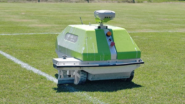
Turf Tank is an autonomous, GNSS-guided line-marking robot built specifically to paint lines on athletic fields.

More than 550 Turf Tank robots are deployed across the United States, painting athletic fields at public schools, major colleges and universities, amateur and professional soccer clubs, local parks and recreation departments, and a two National Football League stadiums.

The Turf Tank robots can paint a full soccer field in less than 30 minutes, compared to two or three hours for manual painting. Similarly, the robot can paint a football field in two or three hours compared to eight to 10 hours to paint a football field.

The robots are eco-friendly — they’re powered by rechargeable batteries and use far less paint than most older paint machines.