Integritet och cookies: Den här webbplatsen använder cookies. Genom att fortsätta använda den här webbplatsen godkänner du deras användning.
Om du vill veta mer, inklusive hur du kontrollerar cookies, se:
Cookie-policy
On Oct. 7, China launched a pair of satellites designed to enhance BeiDou navigation signals.
The CentiSpace-1 S5 and S6 satellites were launched via a Long March 11 solid rocket that lifted off at 9:10 a.m. EDT from a mobile sea platform in the Yellow Sea. Launch success was confirmed by the China Aerospace Science and Technology Corporation (CASC) 90 minutes later.
The CentiSpace-1 satellites are designed to enhance the accuracy of signals from China’s Beidou navigation and positioning satellite system. The satellites will also conduct inter-satellite laser link experiments.
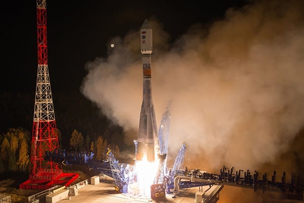
A Fregat booster successfully delivered a Glonass-K navigational satellite into its designated orbit, Russia’s Defense Ministry reported on Oct. 10. Glonass-K No. 17L is the fifth K satellite to join the constellation.
“A Soyuz-2.1b medium-class carrier rocket that blasted off at 05:52 a.m. Moscow time on October 10 from the Plesetsk spaceport in the Arkhangelsk Region successfully delivered a Russian Glonass-K navigational satellite into the target orbit at the designated time,” the ministry said in a statement.
Liftoff and the delivery into the designated orbit proceeded in normal mode, the ministry said, and the ground-based facilities of Russia’s Aerospace Forces assumed control.
“The Russian Glonass-K navigational space vehicle launched on Monday, October 10, from the Plesetsk spaceport by a combat team of the Space Troops of the Aerospace Forces was delivered into the target orbit at the designated time and placed under the control of the ground-based facilities of the Titov Main Testing Space Center of the Aerospace Forces’ Space Troops,” the statement said.
Stable telemetry communications have been established and are being maintained with the satellite. The space vehicle’s onboard systems are operating in normal mode, the ministry said.
The Glonass-K is a third-generation satellite of the Russian global navigation satellite system (Glonass). The satellite was engineered and manufactured by the Reshetnev Information Satellite Systems Company (part of Russia’s State Space Corporation Roscosmos). The satellite was developed to replace the Glonass-M family of space vehicles.
Military officials from across all branches, federal security personnel, and industry leaders gathered at the AUVSI Defense conference, held Sept. 22 in Alexandria, Virginia, to discuss critical issues surrounding the integration of uncrewed technologies.
In a publication released Oct. 11, AUVSI Senior Economic Research Analyst Aaron Bull summarized key topics discussed at the event, including:
defense priorities for the next-generation uncrewed system
how uncrewed systems will impact the ways wars are fought
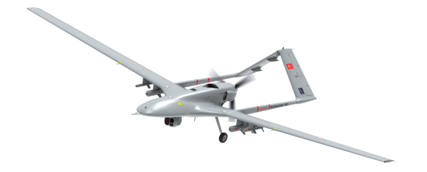
lessons learned by senior defense leaders from the Bayraktar TB2 in Ukraine.
The Bayraktar TB2 surveillance/attack drone (Photo: Baykartech)
Highlights from the Report
Flexibility in the fighting force is needed, which affects the defense requirements for autonomous vehicles heading to the battlefield.
Multiple speakers pointed to the Turkish Bayraktar TB2, a cost-effective combat-capable drone purchased and fielded by the Ukrainian armed forces that has been a game changer for Ukraine since the war began. While the drone is not top of the line, it was fielded quickly, required little training and could be fitted for a variety of purposes. As a result, “Nearly every speaker came prepared to discuss the need for developing multiple layers of flexibility around the U.S. fighting force,” Bull writes.
An uncrewed vehicle that can be refitted for multiple missions of different types offers an inherent advantage for missions, and it requires supporting logistical infrastructure.
Requirements include:
flexibility and disguise of role
ability to outfit to different technical and operating capabilities
flexibility to operate with different levels of human interaction
SBG Systems has launched the Quanta Micro, a navigation system in an extremely compact form factor with a dual-frequency, quad-constellation GNSS receiver for centimeter position with a high-performance inertial measurement unit (IMU).
The Quanta Micro is a real-time kinematic (RTK) capable, miniature inertial sensor that measures 50 mm x 37 mm x 23 mm and weighs 38 g. Its high-end performance includes centimeter positioning, roll/pitch with less than 0.02° error, and heading with less than 0.06° error. It is suitable for all applications, especially those that have low size, weight, power and cost (SWaP-C) requirements. Quanta Micro has already been selected for the development of lidar payloads for UAV and mobile-mapping systems.
To achieve such performance in the harshest conditions, Quanta Micro benefits from SBG Systems’ unique experience in designing and manufacturing inertial sensors, including an individual calibration of each of the manufactured sensors across the full range of working temperatures (–40° C to +85° C).
Lidar point cloud of SBG Systems’ head office created using the Quanta Micro. (Photo: SBG Systems)
Despite its compact form factor, Quanta micro embeds all the features usually present in the other SBG inertial sensors: a built-in datalogger, Ethernet connectivity, a PTP server, multiple serial ports, a CAN port and more. It is easy to configure with a user-friendly built-in web interface; but can also be configured using SBG systems’ API or ROS drivers.
While the Quanta Micro supports dual GNSS antenna mode to improve heading accuracy in low dynamic applications, it has been designed to maintain exceptional heading performances even in a single antenna configuration. This makes it the right tool for UAV payloads that cannot embed two GNSS antennas.
Post processing with Qinertia. To further enhance its extreme real-time performances, the data acquired from the Quanta Micro can easily be post-processed using Qinertia: SBG’s own post-processing kinematic tool. This allows users to process the data with tight coupling of the GNSS and inertial data, and a merge of forward and backward solutions allowing it maintain centimeter precision even during multiple seconds of GNSS outages. It also improves heading errors to less than 0.035° and roll/pitch to less than 0.015°.
Hexagon AB, which offers digital-reality solutions combining sensor, software and autonomous technologies, will integrate AVVIR’s artificial-intelligence-powered technology stack into its portfolio of solutions that address challenges of the construction lifecycle.
Since 2017, AVVIR has enabled intelligent, data-driven job sites that empower commercial, infrastructure and industrial construction professionals to reliably and safely deliver on schedule and within budget, Hexagon stated in a press release.
AVVIR’s reality-analysis platform is focused on building information modeling (BIM). It is designed to improve project workflows, schedules and outcomes by leveraging onsite reality-capture data, enriched BIM models and artificial intelligence. The solution gives construction teams control with automated schedule tracking, cost and earned value analysis, installation issue detection, and an updated BIM with as-built conditions.
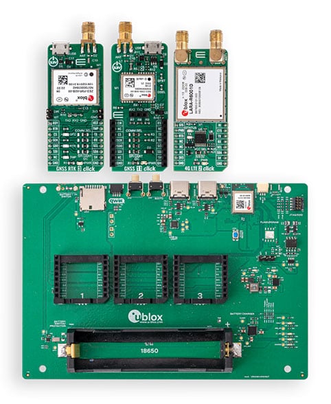
The development kits will bring together u-blox’s centimeter-level positioning and wireless communications expertise and services to support faster time-to-market for new products
The XPLR-HPG-1 high-precision GNSS explorer kit. (Photo: u-blox)
U-blox has announced new explorer kits to make it quicker and easier for engineers to design and evaluate products requiring centimeter-level positioning capabilities.
Set to launch in early 2023, the ready-to-use XPLR-HPG-1 and XPLR-HPG-2 solutions will combine u-blox’s unique offering across the key technologies required to achieve highly precise positioning.
As well as an open microcontroller unit (MCU), the kits will include high-precision GNSS positioning with real-time kinematic (RTK), dead-reckoning, cellular, Wi-Fi and Bluetooth communications, along with the necessary antennas.
The kits are designed to integrate seamlessly with complementary u-blox services, such as PointPerfect GNSS augmentation service and the ubxlib software component.
The XPLR-HPG-2 High precision GNSS explorer kit. (Photo: u-blox)
The kits will assist engineers working in areas such as micro-mobility and low-speed robotics, helping them build, test and demonstrate early-stage proofs of concept more quickly, supporting faster overall time-to-market.
Both explorer kits will include the full gamut of u-blox technology and software required.
The modular XPLR-HPG-1 kit will be based around the wireless MCU in the u-blox NORA-W106 , with its Wi-Fi and Bluetooth LE capabilities, and will give engineers flexibility to adjust their solutions to their precise needs, using MIKROE Click boards featuring a variety of u-blox modules. The kit will include three Click boards, which respectively incorporate the ZED-F9R high-precision RTK GNSS module, the LARA-R6001D LTE Cat 1 module (global coverage and with built-in MQTT client), and the NEO-D9S L-band correction data receiver module. Engineers can purchase others based on their application’s needs. The kit’s source code will include example software for the Espressif IoT Development Framework (ESP-IDF), based on ubxlib software components.
The compact XPLR-HPG-2 will deliver an integrated solution, incorporating the ZED-F9R high-precision RTK GNSS, LARA-R6001D LTE Cat 1 (with global coverage and built-in MQTT client) and NEO-D9S L-band correction data receiver modules, as well as the NINA-W106 with its MCU, Bluetooth LE and Wi-Fi capabilities.
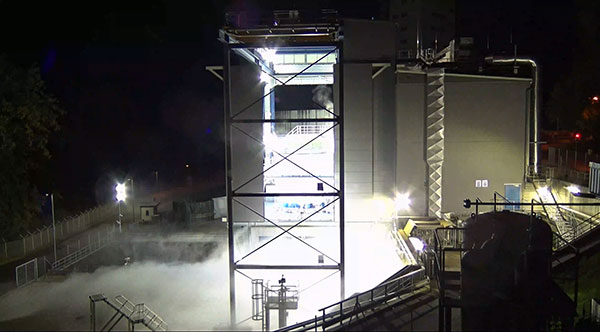
The Ariane 6 launch vehicle program has taken a dramatic step towards first flight with the start on Oct. 5 of hot-fire tests of the rocket’s upper stage and its all-new Vinci engine, according to the European Space Agency (ESA).
The tests are a significant step forward. They are being conducted using the specially built P5.2 test bench for engine and stage testing at the German Aerospace Center (DLR) in Lampoldshausen. The P5.2 test bench subjects the entire upper stage to operating conditions representative of a flight from Europe’s Spaceport in French Guiana, with the exception of vacuum and microgravity.
New Vinci Engine
Vinci, the upper stage engine of Ariane 6 fed by liquid hydrogen and oxygen, can be stopped and restarted multiple times — a critical capability for the complex missions demanded by launch customers today.
The rocket can place several satellites into different orbits and de-orbit the upper stage, leaving a minimum of hazardous debris in space. Vinci also has been developed for reliability, simplicity and lower costs.
Replacement Heavy Launcher
This test series is a critical milestone on a development path that will soon see Ariane 6 replace Ariane 5 as ESA’s heavy launcher.
For more than a quarter century, Ariane 5 has been a reliable partner for commercial, institutional and scientific clients. One of its most notable missions was the Dec. 25, 2021, flight that carried the NASA/ESA/CSA James Webb Space Telescope to its operational outpost in deep space.
But Ariane 6 will be an even more versatile vehicle, strengthening Europe’s autonomy in accessing space.
Auxiliary Power Unit
The tests being run at Lampoldshausen are also evaluating an innovative auxiliary power unit (APU) that works in tandem with the Vinci engine and is instrumental to Ariane 6 upper-stage performance.
To restart in space, earlier engines relied on large quantities of tanked helium to generate the necessary pressure and temperature in the propellant tanks and to ensure there are no bubbles in the fuel lines. However, the APU delivers these conditions using only small amounts of the cryogenic hydrogen and oxygen already carried in the main tanks.
Heading to ESTEC
The test series is being run by DLR and ArianeGroup, the Ariane 6 launcher prime contractor. When the test series is complete, the upper stage — integrated by ArianeGroup at its facility in Bremen, Germany — will be shipped to ESA’s ESTEC technical center in the Netherlands for stage separation and acoustic tests.
Ultimately, the Lampoldshausen tests will investigate hardware behavior and system function of the complete stage with its tanks, engines and avionics.
“The preparation for these hot firing tests is even more complex than for an actual launch,” said Ariane 6 launcher program manager Guy Pilchen. “Our colleagues in Lampoldshausen have decades of experience in rocket propulsion with extremely advanced test facilities. With ArianeGroup colleagues to control the upper stage and DLR people operating the test bench, we couldn’t ask for a better team.”
Space independence for Europe
ESA Director of Space Transportation Daniel Neuenschwander said that this new engine and the upper stage it powers are indispensable components of Ariane 6 and its objective — to guarantee that Europe maintains independent, competitive and sustainable access to space.
“It’s a fact in the 21st century that Europeans depend on space for safety, prosperity and security,” Neuenschwander said. “Europe needs to work toward complete autonomy in accessing and operating in space. Ariane 6 is key to this, and we are eager to see the liftoff from Europe’s Spaceport in French Guiana.”
Ariane 6 Vinci engine testing at DLR Lampoldshausen. (Photo: ESA)
Global corporation VIAVI Solutions Inc. has completed the acquisition of Jackson Labs Technologies, a leader in positioning, navigation and timing (PNT) solutions for critical infrastructure serving both military and civilian applications.
Jackson Labs develops and supplies modules, subsystems and box-level solutions that include front-end receivers, transcoders, rack-mounted equipment, and patented retrofit technology. Their broad customer base includes armed forces, defense contractors, energy distribution infrastructure, low-Earth-orbit (LEO) operators and 5G service providers.
Jackson Labs’ next-generation M-code solutions complement and advance VIAVI’s timing and synchronization portfolio at a time when PNT requirements for defense, space, commercial aviation, transportation and telecommunication networks are expanding and becoming increasingly critical.
“As telecommunications, avionics and mission-critical infrastructure adopt next-generation technology, legacy timing and synchronization protocols are no longer sufficient. Jackson Labs is a trusted provider of PNT solutions in these markets, and we look forward to addressing these opportunities together,” said Oleg Khaykin, president and CEO of VIAVI. “With this acquisition, we are continuing to drive operational scale via the addition of advanced technology and high-performance products that address market segments with strong growth and profitability.”
“Being a part of VIAVI will significantly expand Jackson Labs Technologies’ market reach worldwide, and allow us to further deliver world-class solutions for the rapidly developing PNT landscape as it enters a new era,” said Said Jackson, CEO of Jackson Labs Technologies.
DelMorgan & Co. acted as the exclusive financial advisor to Jackson Labs in connection with the transaction. Terms of the transaction are not being disclosed.
About VIAVI
VIAVI s a global provider of network test, monitoring and assurance solutions for communications service providers, enterprises, network equipment manufacturers, original equipment manufacturers, government and avionics. It helps customers harness the power of instruments, automation, intelligence and virtualization.
VIAVI is also a leader in light management solutions for the anti-counterfeiting, consumer electronics, industrial, government and automotive markets.
VIAVI operates offices throughout North, Central and South America, Europe, Africa, the Middle East, and the Asia-Pacific, including China and Japan.
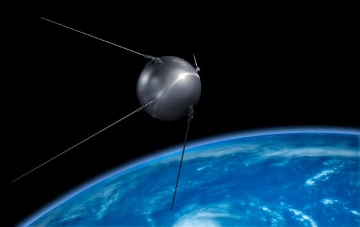
The world watched in awe and a bit of terror as the 23-inch polished metal sphere arced across the sky. Its elliptical, 65-degree declination low-Earth orbit covered virtually the entire planet. Its beep, beep, beeping could be easily heard by professional and armature radio operators alike.
The Soviet Union had just put the world’s first artificial satellite, Sputnik I, in space. It was Friday, the 4th of October, 1957.
The Soviets had gained the high ground, quite literally. The Space Race had begun. As had the West’s greatly increased focus on education in science and engineering. School children in the United States would never lack for homework again.
On Monday, the 7th of October, scientists William Guier and George Weiffenbach arrived to work at the Johns Hopkins University Applied Physics Laboratory in Laurel, Maryland. To their surprise, they found no one had been listening in on Sputnik’s signal over the weekend. So, they decided to do just that. Just for good measure, they also recorded it.
Thus began a series of events that led directly to every satellite navigation system that has come since.
Guier and Weiffenbach’s story was documented in the Johns Hopkins Technical Digest in 1997. It is a fascinating tale of discovery. I highly recommend it.
And it may be a good reason for October 7 to become “World SatNav Day.”
The Indian government is pushing smartphone makers to sell devices that receive NavIC signals along with GPS.
India originally stated NavIC would be required in smartphones sold starting in January 2023, according to Reuters, but strong reaction from smartphone manufacturers Apple, Xiaomi and Samsung apparently caused the government to push back or remove the deadline.
A deadline of January 2023 would not allow enough time for smartphone makers to integrate NavIC-enabled receivers to their devices. Steps include redesign, securing parts, testing and assembly. Many smartphones sold in India by the companies are economy-level devices priced under US$200.
The three tech giants met with government officials, seeking an extended target date of 2025, Reuters reported.
However, India’s Ministry of Electronics & IT issued a statement via Twitter :
A media report has claimed citing a meeting that mobile cos were asked to make smartphones compatible with NavIC within months. This is to clarify: (1) No timeline has been fixed. (2) The cited meeting was consultative; and (3) the issue is under discussion with all stakeholders.
NavIC (Navigation with Indian Constellation) is the operational name for the Indian Regional Navigation Satellite System (IRNSS) developed by India’s space agency for military and commercial purposes. NavIC consists of eight satellites that cover the Indian mainland and the region extending up to 1,500 km from its boundaries.
“NavIC can help in navigation on land, air, sea and also in disaster management,” Science & Technology Minister Jitendra Singh said in a press release. “NavIC satellites are placed at a higher orbit than the GPS of United States. NavIC satellites are placed in geostationary orbit (GEO) and geosynchronous orbit (GSO) with an altitude of about 36,000 km; GPS satellites are placed in medium earth orbit (MEO) with an altitude of about 20,000 km.”
“NavIC uses dual-frequency bands, which improves accuracy of dual-frequency receivers by enabling them to correct atmospheric errors through simultaneous use of two frequencies,” Singh said. “It also helps in better reliability and availability because the signal from either frequency can serve the positioning requirement equally well.”