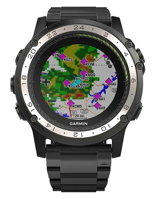
Weather radar overlay feature within Garmin D2 Charlie. (Photo: Garmin)
The U.S. Air Force is expected to take delivery of more than 100 D2 Charlie aviator watches for the specialized pilot group that flies the Lockheed U-2 aircraft.
Garmin’s D2 Charlie aviator watch has been selected by the United States Air Force (USAF) for use by the pilots of the Lockheed U-2 aircraft.
The high-sensitivity WAAS GPS-enabled D2 Charlie aviator watch incorporates global navigation capability, rich and colorful moving maps and more, providing pilots in the USAF with an exclusive, back-up navigation timepiece in the cockpit.
The watch receives both GPS and GLONASS signals.
U-2 for reconnaissance. The U-2 is a versatile, ultra-high-altitude reconnaissance aircraft used for intelligence gathering, research and communication purposes.
The U-2 provides high-altitude, all-weather surveillance and reconnaissance, day or night, in direct support of U.S. and allied forces. It delivers critical imagery and signals intelligence to decision makers throughout all phases of conflict, including peacetime indications and warnings, low-intensity conflict, and large-scale hostilities.
100 watches ordered. The USAF is expected to take delivery of more than 100 D2 Charlie aviator watches for the specialized pilot group that flies the Lockheed U-2 aircraft. With a service ceiling of 70,000 feet, the D2 Charlie will provide unique benefits such as barometric-based O2 alerting and GPS-specific features including track, distance to the next waypoint, estimated time enroute and more.
“Garmin is honored to have been selected by the United States Air Force to equip the men and women who fly one of the most iconic aircraft in the history of aviation,” said Carl Wolf, Garmin vice president of aviation sales and marketing. “The D2 Charlie aviator watch will be an integral and functional part of the U-2 pilot’s toolkit.”

A U.S. Air Force U-2 Dragon Lady flies a training mission. (Photo: U.S. Air Force photo by Master Sgt. Rose Reynolds):
Designed with pilots of varying backgrounds and missions, the D2 Charlie aviator watch features a colorful, dynamic moving map which depicts airports, navaids, roads, bodies of water, cities and more, offering greater situational awareness.
When the D2 Charlie is paired with Garmin Connect on a connected mobile device, pilots can view weather radar on top of the map display relative to flight plan information.
Pilots can also display estimated time enroute (ETE), universal coordinated time (UTC) or other pilot-selectable data fields overtop the map so it’s easy to monitor the progress of a flight and view pertinent flight information simultaneously.
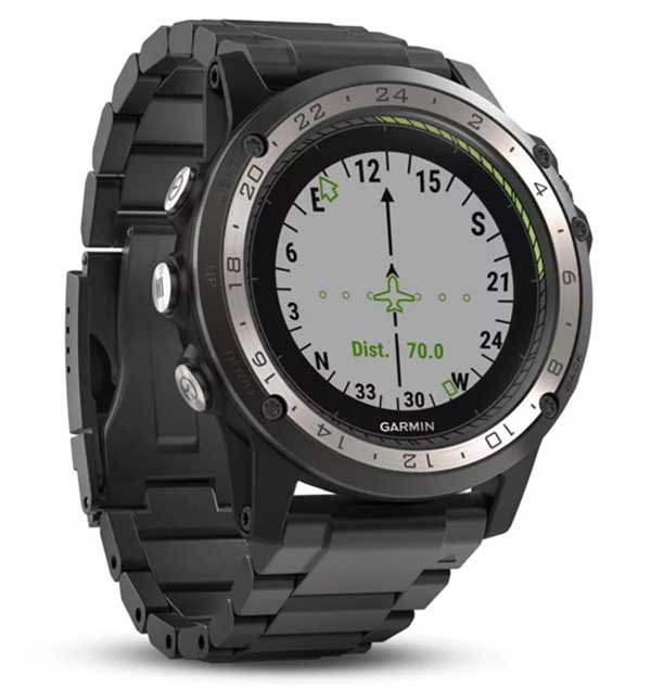
The Direct-to feature within D2 Charlie watch. (Photo: Garmin)
Standalone navigator. An advanced, standalone navigator, the D2 Charlie aviator watch incorporates exclusive navigation functions and capabilities, including dedicated direct-to and nearest buttons along the side of the bezel that allow the user to easily build or modify flight plans.
Airport information pages display communication frequencies, runway information (including dimensions and surface type), weather data and more for a specified airport.
The flight log page allows pilots to conveniently reference recent flights at their wrist, displaying date, flight duration, total distance and more of a particular flight. Additionally, improved flight planning capabilities include the option to add multiple waypoints within a single flight plan and the ability to navigate direct to any waypoint in a flight plan.
Heart-rate monitor. The D2 Charlie is made of premium materials, including a sapphire scratch-resistant crystal lens and a diamond-like carbon-coated titanium bezel for improved durability. A sunlight-readable, high-resolution color display with an LED backlight on the watch face allows pilots to view data in most lighting conditions in the cockpit.
The D2 Charlie offers up to 20 hours of battery life in GPS mode and up to 12 days in smartwatch mode.
Garmin Elevate wrist heart rate technology allows pilots to measure heart rate 24/7 alongside daily activity tracking. The D2 Charlie aviator watch also comes preloaded with a full multisport toolset for running, golfing, cycling, swimming, skiing and more. Water rated to 100 meters, it can also withstand swimming and other water activities. When paired with a compatible smartphone, customers can also view phone calls, text and email smart notifications at their wrist.
Gilla detta:
Gilla Laddar in …