Publicerad den Lämna en kommentar

Inhofe, Reed urge FCC to stay and reconsider Ligado order

A bipartisan group of eight U.S. senators has sent a letter to the Federal Communications Commission (FCC), urging the agency to stay and reconsider the Ligado Networks order.

U.S. Senators Jim Inhofe (R-Okla.) and Jack Reed (D-R.I.), ranking member and chairman of the Senate Armed Services Committee, led the group in sending the letter to FCC Chairwoman Jessica Rosenworcel, urging her to reconsider granting Ligado’s license modification request.

Ligado wants to use a part of the communications spectrum in a way that risks interference with GPS reception, a move that has been decried by many industry insiders as well as other government agencies, including the departments of Defense and Transportation.

The timing of the letter is critical, as Ligado has announced its intention to deploy a terrestrial network as soon as Sept. 30. The National Academy of Sciences plans to release a report on the FCC’s order at a public online briefing at 11 a.m. ET Sept. 9. The report will be available at National Academies Press at that same time.

Imminent Risks

Joining Inhofe and Reed were Sens. Tammy Duckworth (D-Ill.), Mazie Hirono (D-Hawaii), Mark Kelly (D-Ariz.), Mike Rounds (R-S.D.), Kyrsten Sinema (D-Ariz.) and Dan Sullivan (R-Alaska).

The senators write: “Staying and reconsidering the Ligado Order is necessary to address the imminent risks associated with Ligado’s intention to ‘commence operations in the 1526-1536 Mhz band on or after September 30, 2022.’ We remain gravely concerned that the Ligado Order fails to adequately protect adjacent band operations — including those related to GPS and satellite communications — from harmful interference impacting countless military and commercial activities.

“We urge you to set aside the Ligado Order and give proper consideration to the widely held concerns across the Executive Branch, within Congress, and from the private sector regarding the expected impact of the Ligado Order on national security and other systems,” the senators continued.

A copy of the letter can be found here and below.

Dear Chairwoman Rosenworcel:

We write to you today to urge the Federal Communications Commission (FCC) to stay and reconsider the FCC’s order granting the applications of Ligado Networks LLC (Ligado) to deploy a terrestrial wireless network in the L-band satellite spectrum neighborhood, FCC 20-48, adopted April 19, 2020 (the Ligado Order). We remain extremely concerned that terrestrial L-band operations would cause unacceptable risk to Department of Defense (DOD), the Federal Government Global Positioning System (GPS), and Satellite Communications (SATCOM) operations.

Prior to the issuance of the Ligado Order, fourteen federal agencies and departments expressed strong opposition to the applications sought by Ligado over concerns about potential harmful interference with GPS operations. In May 2020, shortly following the issuance of the Ligado Order, on behalf of the executive branch, the National Telecommunications and Information Administration (NTIA) petitioned the FCC to reconsider its decision. That filing requested that the FCC “rescind its approval of the mobile satellite service (MSS) license modification applications” granted to Ligado, which the NTIA asserted would “cause irreparable harms” to federal government GPS users.

Staying and reconsidering the Ligado Order is necessary to address the imminent risks associated with Ligado’s intention to “commence operations in the 1526-1536 Mhz band on or after September 30, 2022.” We remain gravely concerned that the Ligado Order fails to adequately protect adjacent band operations—including those related to GPS and satellite communications—from harmful interference impacting countless military and commercial activities. We urge you to set aside the Ligado Order and give proper consideration to the widely held concerns across the Executive Branch, within Congress, and from the private sector regarding the expected impact of the Ligado Order on national security and other systems.

We look forward to continuing to work with you to ensure that federal spectrum policy adequately protects the millions of military and commercial users who rely on L-band satellite services every day.

Feature photo: Brian Kinney/Shutterstock.com

Publicerad den Lämna en kommentar

Details of September’s CGSIC meeting released, DeLaPena to speak

The 62nd meeting of the U.S. government’s Civil GPS Service Interface Committee (CGSIC) will be held Sept. 19–20 in the Hyatt Regency Denver at the Colorado Convention Center, before the annual ION GNSS+ conference.

It will be hosted by the U.S. Department of Transportation (DOT) and the U.S. Coast Guard Navigation Center (NAVCEN). DOT serves as the civil lead for GPS and chairs the CGSIC in this capacity. NAVCEN is assigned duties as Deputy Chair and Executive Secretariat for the CGSIC.

On Sept. 19, the CGSIC subcommittees for Timing, International Information, and Survey, Mapping, and Geosciences will meet. A summary of these meetings will be presented to the CGSIC Plenary Session on Sept. 20.

Photo:

Cordell DeLaPena, Program Executive Officer for Military Communications and PNT Space Systems Command

Keynote speaker for the plenary session is Cordell DeLaPena, program executive officer for Military Communications and Positioning, Navigation, and Timing, Space Systems Command, Los Angeles Air Force Base.

The agendas for the CGSIC subcommittee and plenary sessions will include presentations on the operational status and modernization of the GPS constellation of satellites, U.S. space-based positioning, navigation and timing (PNT) policy, GPS augmentation systems, and information related to U.S. engagement with other international GNSS as well as a variety of interesting applications of the use of GPS.

Several new briefings are part of the plenary session this year, including a presentation from NASA on the role of GPS in support of the next lunar mission. Also, the Department of Homeland Security will provide an update on the activities of the Office of Infrastructure Protection, Positioning, Navigation, and Timing Program Management Office.

This year’s meeting will be live-streamed over the internet. For those who are unable to travel, the meetings can be accessed with the links below.

The agenda for the meeting is available; all CGSIC presentations will be available there for viewing online shortly after the meeting ends. As a reminder, all CGSIC meetings are free and open to the public.

Surveying, Mapping and Geo-Sciences Subcommittee
Sept. 19, 9 a.m. – 12:30 p.m. MDT
Chair: John Galetzka, NGS
Co-Chair: Neill Winn, NPS

International Information Subcommittee
2–5 p.m. MDT
Chair: John Wilde, CEO, Spacekeys

Timing Subcommittee
2–5 p.m. MDT
Chair: Patricia Larkoski, The MITRE Corporation
Co-Chair: Bijunath Patla, NIST

Plenary Session
Sept. 20, 9 a.m. – 5 p.m.
Chair: Karen Van Dyke, DOT
Deputy Chair: Cpt. Scott Calhoun, USCG

Publicerad den Lämna en kommentar

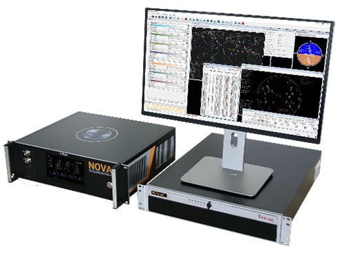
IFEN releases new NCS Nova RF signal simulator

Release V2.8 provides advanced interference, spoofing, encryption and authentication simulation capability

Photo: IFEN

Photo: IFEN

IFEN GmbH has released a new version of its NCS Nova RF signal simulator, offering a full package of advanced simulation capabilities.

With its now-integrated interference generation capability (AWGN, CW, pulsed and chirp), NCS Nova version 2.8 can generate coherent interference signals with a signal power of up to –30 dBm.

The ability to assign two users to one RF output enables integrated spoofing scenarios with a single RF output (one user is the original simulated user; the other is the target spoofing user). Thus, spoofing is available even with an entry-level single RF Nova.

The key feature of this new release is the new navigation message authentication (NMA) simulation capability, compliant to User ICD 1.0 for the Galileo E1-B OSNMA. Beyond basic authentication-testing capability, specific OSNMA events can be simulated. Testing OSNMA-enabled receivers under these specific events is key to ensuring compliant receiver behavior. The supported events include both a public key renewal and revocation and TESLA keychain renewal and revocation. Also, GPS cross-authentication is fully supported.

Finally, the new release fully supports generation of Galileo E6-C encrypted codes. This enables users to take full advantage of the Galileo third-frequency pilot signal.

Publicerad den Lämna en kommentar

Who will survey?

Matteo Luccio

Luccio

“Nothing can remain immense if it can be measured,” Hannah Arendt wrote in 1958 in The Human Condition. This could be the guiding inspiration for any geodesist or surveyor throughout history. In about 240 B.C., Eratosthenes became the father of geodesy by ingeniously measuring Earth’s circumference using the Sun, a well, a vertical column, the distance a camel caravan traveled from Syene to Alexandria and some basic mathematics. His estimate of 46,000 kilometers was 16% too large but remarkably close considering that he lacked any modern measuring tool. (For a great account of this epic feat, see John Noble Wilford’s The Mapmakers.)

Geodesy, a branch of applied mathematics, is concerned with accurately measuring and understanding three of Earth’s fundamental properties: its geometric shape, its orientation in space, and its gravity field. Earth’s true shape varies from the mathematically smooth surface of an ellipsoid due to local differences in its density that cause variations in the strength of the gravitational pull, in turn causing regions to dip below or bulge above a reference ellipsoid.

This undulating shape is the geoid, which geodesists have defined as the three-dimensional surface along which the pull of gravity is a specific constant. It serves as the zero-level surface for height measurements globally, and all GNSS are pegged to it. It is a hypothetical surface that essentially represents an extension of the idealized mean sea level over (actually, mostly under) Earth’s land surface. Unlike the surface of the oceans, however, it is unaffected by wind, waves, the Moon, or forces other than Earth’s gravity.

Surveyors are content with measuring much smaller portions of Earth’s surface, from single lots to national boundaries. Unlike Eratosthenes, they work with the latest fruit of modern science and technology — including GNSS receivers, robotic total stations, inertial measurement units, lidar, other sensors and unmanned aerial vehicles — and can measure distances with millimeter precision.

When I started in this business a little more than 20 years ago, we used to group GPS receivers by accuracy into three buckets: consumer grade, resource/mapping grade and survey grade. As accuracy has increased for all GNSS receivers, the boundaries between those categories, especially between mapping and surveying, have blurred. Additionally, we now have way more GNSS satellites — in some parts of the world, as many as 70 are in view at one time — and a panoply of public and private, ground-based and satellite-based corrections services.

So, surveyors have a growing set of tools, and they are constantly getting more accurate and more user-friendly.

Now, let me throw another number in the mix: 66. That is the average age of surveyors in the United States. In the short run, employment for surveyors hinges in part on the vagaries of the economy. In the long run, however, population growth and climate change will force large investments in infrastructure. On most construction sites, the first to arrive and the last to leave are the surveyors. We know what their tools are, but who will they be?

Publicerad den Lämna en kommentar

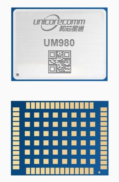
Unicore releases GNSS RTK module, the UM980

Photo: Unicore

Photo: Unicore

Unicore Communications has released its new generation of high-precision GNSS module. The UM980 uses real-time kinematic (RTK) technology to achieve centimeter-level positioning accuracy.

The UM980 is based on the small high-performance system-on-chip NebulasIV, which integrates radio frequency, baseband and high-precision algorithms on a single chip. It has 1,408 channels to concurrently receive satellite signals from multiple constellations and multiple frequencies.

The UM980 module can track BDS B1I/B2I/B3I/B1C/B2a/B2b, GPS L1/L2/L5, GLONASS L1/L2, Galileo E1/E5a/E5b/E6 and QZSS L1/L2/L5, as well as supporting SBAS.

Its advanced multi-mode multi-frequency computing engine provides powerful signal processing ability, characterized by fast initialization time, accurate positioning results, and a high data-update rate of up to 20 Hz.

The UM980 features low power consumption, typically 480 mW. The module is a surface mount device (SMD) measuring 17 x 22 x 2.6 millimeters. Compared to Unicore’s previous generation of high-precision GNSS modules, the UM980 is nearly half the size while the performance remains excellent.

The UM980’s compact form occupies less printed-circuit-board area and makes the product more portable. The UM980 is also equipped with an advanced anti-jamming unit, which ensures high reliability even in complex electromagnetic environments.

Thanks to its high precision, high performance and high reliability, UM980 is suitable for applications in surveying, mapping and precision agriculture. The UM980 is qualified according to the international quality standards (RoHS, REACH, CE, FCC, and IC) and is in mass production.

Publicerad den Lämna en kommentar

DeepRoute.ai completes L4 driverless test in busy Shenzhen, China

The company tested Driver 2.0, a Level 4 production-ready autonomous driving solution

New video highlights navigating heavy traffic safely and efficiently

Photo: DeepRoute.ai

Photo: DeepRoute.ai

DeepRoute.ai, an international autonomous driving technology company, has announced the results of its latest fully driverless test of its Driver 2.0 Level 4 production-ready autonomous driving solution.

DeepRoute.ai released a video exhibiting a driverless vehicle retrofitted with the solution on Central Business District roads in Shenzhen, demonstrating its advanced capacity in complex and challenging traffic environments. It was the first legal driverless test in China — Shenzhen unveiled China’s first regulation on intelligent connected vehicles on July 6.

The fully driverless vehicle drove just under 14 miles in one hour, navigating through significant traffic and narrow lanes safely and efficiently. The vehicle:

  • intelligently maneuvered around double-parked cars and counterflow e-scooters and pedestrians
  • negotiated with oncoming vehicles to calculate the right timing and trajectory to pass busy intersections
  • conducted multiple lane changes and unprotected left turns.

“The recent legislation permitting driverless robotaxis in Shenzhen is the first of its kind, a major milestone in advancing autonomous driving technology to wider and faster adoption,” said Maxwell Zhou, CEO of DeepRoute.ai. “As we advance our mission for commercial deployment of autonomous driving vehicles, we will collaborate with automakers to refine our L4 solution to make it as safe and efficient as possible.”

DeepRoute.ai has made significant improvements to achieve driverless capability, with both software and hardware meeting auto-grade standards. The safety mechanism was also upgraded to guarantee driverless safety on the road. In the case of long tail scenarios, the system will alert the remote monitoring center to intervene or take other safety measures.

The Driver 2.0 System

Driver 2.0 includes five solid-state lidar units, eight cameras and other sensors, and a computing platform integrated with its proprietary inference engine. The perception algorithm with sensor fusion can achieve precise object detection up to nearly 220 yards. The planning and control algorithm based on game theory can choose optimal routes and make decisions based on real-time situations when negotiating with oncoming vehicles and other road agents.

With its deep learning approach, the inference engine optimizes compute resources, allowing the algorithm to run on its low-cost and power-efficient computing platform effectively and stably. As a result, Driver 2.0 can be priced at $3,000 for automakers in mass production and the algorithm can work with 2 to 5 solid-state lidars for automakers’ customization needs.

The latest legal and regulatory framework is aligned with autonomous-driving industry developments and is considered the prelude to mass production and commercialization of autonomous-driving vehicles. DeepRoute.ai is working with automakers to mass produce consumer vehicles integrated with Driver 2.0, expected to be available for consumer purchase in 2025. It is also being integrated into robotaxi operations.

Photo: DeepRoute.ai

Photo: DeepRoute.ai

Publicerad den Lämna en kommentar

DroneShield delivers handheld counter-UAS solutions to U.S. government

DroneShield's RfPatrol MKII bodyworn system antennas. (Photo: DroneShield)

DroneShield’s RfPatrol MKII body-worn system antennas. (Photo: DroneShield)

DroneShield has received and delivered upon a follow-on order by a U.S. government agency for the company’s portable and handheld counter-UAS (C-UAS) solutions.

DroneShield is the maker of the counter-drone or anti-drone systems including RfPatrol and DroneGun MkIII. It has received contracts from the U.S. departments of Defense and Homeland Security, as well as other federal and state law enforcement agencies.

“We’re grateful for the continued trust that this organization has placed in us to help address a unique set of operational challenges. Our customer relationships are what fuel our commitment to push the boundaries of what’s possible in the counter unmanned space,” said Tom Branstetter, director of business development, DroneShield. “Every teammate at DroneShield understands the significance of the problems we’re solving for our end-users and it’s something we’re proud to support.”

DroneShield also recently announced deployments of its solutions for high-profile events including the World Economic Forum (WEF) in Davos, Switzerland, and IRONMAN Texas 2022.

Publicerad den Lämna en kommentar

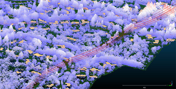
Teren kicks off nationwide lidar content library program

Image: Teren

Image: Teren

Teren, a climate resilience analytics company, has expanded its Premium 4D Content program for regions across the United States, including the Gulf Coast, Midwest, Rocky Mountains and West Coast.

Teren acquires and quickly processes high-fidelity lidar data, making it available via its content library, and delivers analytics with actionable insights to energy and engineering firms.

“Climate change is causing drought, flooding, landslides and wildfires across the country – significantly impacting asset owners and project developers. As a result, the market demand for high-fidelity, temporal data to identify, prioritize, and monitor climate-related risk is higher than ever,” said Toby Kraft, Teren CEO.

Teren is amassing a content library of remotely-sensed 3D (spatial) data across the United States. That data is updated on regular intervals to monitor changes over time providing a unique 4D (temporal) view. This 4D data library feeds analytics that identify risk, inform mitigation, and strengthen asset resilience. While remotely-sensed data has traditionally been sourced on a project-by-project basis, Teren offers its data and analytics as a subscription service. This model drives down the costs for clients and stakeholders, helping to maximize the speed of delivery, return on investment, and data value.

“In our flagship content region, Appalachia, our customers tap into our 4D content library to identify and monitor the terrain and surface conditions surrounding their assets — primarily aiming to identify and mitigate landslides before they become catastrophic incidents,” Kraft said. “We’re expanding the program nationwide to meet the growing demand for terrain monitoring and climate resilience analytics around events such as erosion, flooding, wildfires and more.”

Teren’s solution saved clients in Appalachia an estimated $152 million annually, preventing 24 failures per year due to landslides. While landslides are not as pervasive across the United States, companies can apply the data and analytics suite for the following:

  • Gulf Coast: inundation, subsidence, land movement
  • Midwest: erosion, flooding, subsidence
  • Rock Mountains: landslides, flooding, wildfire
  • West Coast: wildfires, land movement, flooding.

Traditionally used by the energy sector, Teren’s data has also proven to be highly valuable to state and federal agencies, insurers and civil engineers. Teren expects to see increased variability across clients and use cases as the content region expands.

To learn more about Teren or to request a demo, visit www.teren4d.com.

Publicerad den Lämna en kommentar

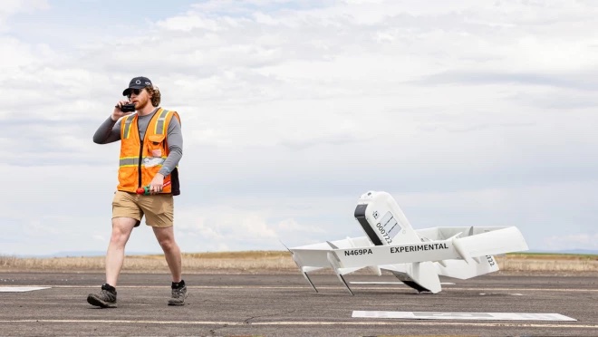
Amazon shows how it’s building drone delivery system

Amazon has put out a video to show how the company is building its drone delivery service. The fully electric drones is designed to deliver packages under 5 pounds to customers in less than 60 minutes.

Later this year, customers living in Lockeford, California and College Station, Texas will be among the first to receive Prime Air drone deliveries.

Three components are integral to the system:

  • The drone itself, which Amazon said is as robust and reliable as its ground transportation trucks.
  • A sense-and-avoid system for obstacles such as other aircraft, people and pets in backyards.
  • An automated drone-management system to plan flight paths and ensure safe distances between the drones and  other aircraft in the area, and ensure compliance with aviation regulations.

Amazon has been developing its drone delivery system for almost a decade, employing experts in safety, aerospace, science, robotics, software, hardware, testing and manufacturing.

Below is an inside look at an Amazon flight-testing facility in Oregon.

Photo: Amazon

Photo: Amazon

Photo: Amazon

Photo: Amazon

Publicerad den Lämna en kommentar

Trimble adds integrity monitoring to Centerpoint RTX FAST service

Trimble has introduced data integrity monitoring for CenterPoint RTX Fast, its precise point positioning (PPP) correction service.

The Trimble RTX Integrity monitoring system is an innovative, patented solution, built in direct response to client requirements for production-ready applications. It continuously validates the reliability of correction data processed by the network, which is broadcast to users in the agriculture, geospatial, construction and automotive industries, ensuring positioning data is right the first time.

Through a two-step process, the Trimble RTX Integrity system verifies the integrity of GNSS data and filters faulty information in the network server before the data is broadcast. A secondary post-broadcast check is conducted on the entire data transmission process where additional errors may be detected and removed.

The integrity monitoring system is fully automated and reacts in seconds to detect, isolate and block faulty data to provide even more highly accurate and reliable positioning.

Trimble RTX Integrity is comprised of independent monitoring stations strategically positioned across RTX Fast networks in the United States, southern Canada and across Europe. These stations continuously monitor data output during multiple stages of the Trimble RTX positioning process. Any suspicious satellite data is removed during the integrity protection process and positioning is calculated using only validated data.

Photo: Trimble

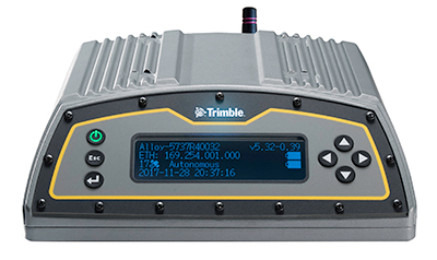
Trimble Alloy GNSS reference receiver. (Photo: Trimble)

Trimble Alloy GNSS reference receivers power the independent monitoring stations using redundant internet connectivity for added reliability. To date, no other positioning network offers the same level of data integrity validation across such expansive, contiguous geographies.

Trimble RTX Integrity monitoring system was developed in accordance with Automotive Software Performance Improvement and Capability dEtermination (ASPICE) and ISO 26262 automotive safety standards, making it easy to integrate into major automotive manufacturers’ autonomous driving systems.

Trimble RTX Integrity can also be used by Trimble’s customers in the agriculture, geospatial and construction industries to ensure correction stream integrity and reliability for applications such as machine control and high-accuracy surveying applications.

“Trimble remains committed to exceeding expectations by providing accurate corrections to our customers to support safety-critical and other day-to-day applications,” said Patricia Boothe, SVP of autonomy, Trimble. “Implementing additional checks and balances to ensure our data is authenticated, trustworthy and accurate is of paramount importance to maintaining the integrity of our RTX network and instilling confidence with our users that the data is correct.”