Publicerad den Lämna en kommentar

Robotic Research innovates to help fight COVID-19

D.C.-area engineering firm produces reusable face shields for region’s hospitals, offers sterile 3D printer patent for COVID applications globally

The team of engineers at Robotic Research LLC, based in Clarksburg, Maryland, is applying its innovative engineering expertise to create new solutions for healthcare workers to help fight the COVID-19 crisis in the Washington area and around the world.

Robotic Research is a provider of autonomy and robotic technologies for government and commercial customers.

The company has created a unique design for reusable face shields and is providing the shields to healthcare teams in hospitals around the Greater Washington Metro area. The company also just opened up its patented design of its sterile 3D printer by waiving licensing fees globally for any application of the printers related to fighting the current public health pandemic.

Face shields

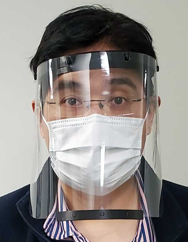
Face shield printed for health-care workers to help fight COVID-19. (Photo: Robotic Research)

Face shield printed for health-care workers to help fight COVID-19. (Photo: Robotic Research)

The face shields, which Robotic Research is printing on standard industrial 3D printers at its robotics engineering facility in Clarksburg, are being delivered to support teams at hospitals in the Montgomery County area.

The face shield design provides comfort and protection, and features an improved disinfection process capability using materials compatible with hospital cleaning methods. The design has been approved for use in select departments, with broader uses under evaluation.

“Our team wanted to help out in any way we could to support the local frontline health-care providers who are working around the clock to assist those impacted by the COVID-19 public health crisis,” said Alberto Lacaze, president of Robotic Research. “We are producing a face shield that modifies a design based off the blueprint provided by the National Institutes of Health. The design includes some enhancements to further protect from aerosol in the temple area and allow the masks to be cleaned and therefore reusable, as well as comfortable to wear over prolonged use.”

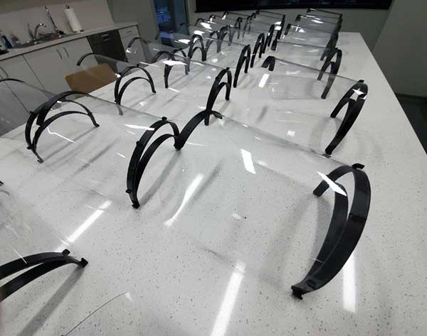
Robotic Research has sourced materials from across the country to support the production of approximately 2,000 face shields. The company is seeking a grant through Montgomery County and the state of Maryland to boost production to approximately 500 shields a day. The company normally uses its standard 3D printers to support many of its robotic products and solutions.

Sterile 3D printer

A batch of face shields prepared fo delivered to a Maryland hospital. (Photo: Robotic Research)

A batch of face shields prepared fo delivered to a Maryland hospital. (Photo: Robotic Research)

Materials used for polymer 3D printing are often damaged by the high temperatures, chemicals or radiation used in standard sterilization processes. Robotic Research’s patented process overcomes this challenge by using a sterile chamber around a 3D printer where unsterilized plastic is brought into the chamber.

The possibly contaminated plastic is sterilized by the printing process and packaged maintaining the sterile field.

This system was initially designed for a U.S. government agency to allow sterile medical materials to be printed at locations where commonly used sterilization methods might not be possible.

“Because this printer can create sterile materials, which are sterile from the inside out once produced, we are eliminating the need for hospitals to re-sterilize equipment before use,” Lacaze said. “At a time when efficiency and supplies are critical, we hope this technology will be able to help alleviate some of the immense pressure hospitals and medical facilities are currently facing. It is our hope that providing the use of this process at no cost may help bring solutions to the health care teams working to save lives during this crisis.”

The unique printer process enables the manufacturing of sterile medical equipment and implantable device components, such as intubation tubes and other materials required during invasive procedures, in a manner that eliminates the need for additional sterilization.

Robotic Research’s patented sterile 3D printing process (USPTO 10,406,758) will be available royalty-free for a minimum of one year for any COVID-19 applications across the globe.

The company is committed to continuing to use its resources and facilities to develop solutions for the ongoing challenges of the COVID-19 pandemic.

Publicerad den Lämna en kommentar

UAVs take flight for Mars, perform deliveries, more

General Atomics MQ-9 Predator. (Photo: General Atomics)

General Atomics MQ-9 Predator. (Photo: General Atomics)

There has been a lot of scene stealing by General Atomics recently with Predators flying hither and thither, new orders for the Boeing-Navy unmanned re-fueling drones and a UAV flying on Mars — this month’s unmanned aircraft summaries.

The Predator is the archetypical unmanned aircraft which most people might visualize as a “drone” as a result of numerous news reports and photos. Its what we might refer to a “Large UAV” with a 65-ft. wingspan, a 35 ft.-long fuselage and weighing in at around ~10,500 pounds fully fueled.

The SkyGuardian. (Photo: General Atomics)

The SkyGuardian. (Photo: General Atomics)

In fact it’s bigger than a small manned aircraft, like the single engine Cessna 182 which checks in at 36ft wingspan/29ft fuselage. So its clear that something this big and without an on-board driver has to watch where its going, especially when flying within in the US National Airspace System (NAS).

So it was no small feat when General Atomics recently flew a new MQ-9 Predator on a delivery flight from its flight ops center in Palmdale, California, to the Holloman Air Force Base in New Mexico. There was significant coordination by the flight teams in both locations, and with the approval by the FAA. Delivering a new Predator by air saves the Air Force significant manpower, as normally new ones arrive in a crate and require effort to re-assemble.

It’s a sign of progress towards achieving approval to allow regular flights of such large UAVs in the NAS. Nowadays a Cessna 182 pilot can file a flight plan and then basically fly anywhere in unrestricted airspace. Hopefully one day — as a consequence of following rigorous certification verification and FAA approval – pilots of such Large UAS will be authorized to operate in a similar fashion.

General Atomics is working with the U.K. Royal Air Force (RAF) to develop and certify the all-weather, long-endurance SkyGuardian MQ-9B variant to meet NATO-standard Type-Certification requirements, which will then enable the UAV to be flown in civil airspace. The Australian Defence Force (ADF) has also selected this UAV variant for its unmanned applications in and around Australia. In late March, General Atomics flew the first production representative SkyGuardian – known to the RAF as the ‘Protector’ – out of its flight ops facility in El Mirage, California.

MQ-25 unmanned aerial refueling aircraft. (Photo: The The Boeing Company

MQ-25 unmanned aerial refueling aircraft. (Photo: The The Boeing Company

Staying with the military theme, Boeing has been working with the US Navy to develop a UAV that can land on aircraft carriers, and following a concept change by the Navy, won a contract to provide tanker UAVs. Tanker UAVs will fill up with aircraft gas on an aircraft carrier or land base, then take off and fly to rendezvous with fighter aircraft to transfer fuel and extend fighter endurance and range.

Right now tanker aircraft are usually quite large aircraft – like the Boeing KC-46A tanker which is based on the Boeing B-767 civil transport aircraft which many of may have flown on as passengers.

The MQ-25 is still in its initial phases, with four test UAVs slated to undertake the initial flight test program. The first test vehicle has already begun exploring the UAV flight envelope and has 30 flight-test hours under its belt. The Navy has just shown confidence in the program by ordering another three aircraft, bringing the total initial build to seven vehicles.

Boeing KC-46A Tanker in-flight refueling. (Photo: The Boeing Company)

Boeing KC-46A Tanker in-flight refueling. (Photo: The Boeing Company)

Its easy to see that UAVs are showing themselves to be extremely useful to military forces, but it might be difficult to understand how a UAV might find itself in the U.S. space program. The “Mars Helicopter” has just been mated to the underside of the next Mars Rover — now called “Perseverance” — both are slated to leave on their eight month journey to Mars in July this year.

Mars UAV being mater with Perseverance. (Photo: NASA)

Mars UAV being mater with Perseverance. (Photo: NASA)

With two ~4ft rotors which spin in opposite directions, the UAV will have to wait patiently for up to 90 Martian Days after Perseverance touches down in February 2012 until it gets a chance to prove that it can fly in the thin Mars atmosphere — chamber tests here on Earth in simulated Mars air have already shown that flight should be feasible.

Built to withstand high g launch and vibration forces and those of the Mars landing, the UAV carries a high resolution camera which is used for navigation, landing and survey of Mars’ surface. Its also designed to withstand the extreme temperatures and high radiation environment on the surface of Mars. The UAV is equipped with a dual-processor flight controller linked to sensors which include a gyroscope, an altimeter, visual odometer, hazard detectors and a ‘visual inertial nav system’ developed by JPL. Although the Mars Helicopter operates autonomously, it communicates with and receives control inputs from the lander, so controllers on Earth load up the flight plan ahead of time into the lander, and then wait for the helicopter UAV to execute the commands. Don’t expect vast coverage of huge panoramas of Mars – its flights are each intended to be more of an extensive hop lasting around 90 seconds at 10-15 ft above the terrain.

Mars Helicopter on simulated Mars surface. (Photo: NASA)

Mars Helicopter on simulated Mars surface. (Photo: NASA)

With a body no larger than a softball and weighing less than 4 p0unds, the Mars Helicopter is an experiment to see if its possible to fly in the extremely thin Martian atmosphere. With less than 1% the density of our sea-level atmosphere, its necessary to spin the rotors at 2,800 rpm, ten times faster than on Earth. The UAV collects power from its own small solar panel and needs several days to recharge after each flight — of which five are planned. The main objective if flight is possible is to pre-survey interesting potential routes for the lander.

So preparations for large UAVs to regularly fly in civilian airspace, a new approach for Navy refueling systems, and a helicopter UAV destined to fly on Mars next year — completely different unmanned applications, all making progress.

Publicerad den Lämna en kommentar

ESA funds fail-safe navigation system for drones

Ampyx Power logo

The European Space Agency (ESA) has funded Ampyx Power, developer of a next-generation wind energy technology, and Omnisense, developer of locating and tracking solutions, to develop a robust fail-safe navigation system.

The positioning solution will be used for automated take-off and landing of Ampyx Power’s wind-energy aircraft when applied offshore or over rugged terrain. The technology will be enabling as well for other drones in critical applications.

Ampyx Power develops airborne wind energy systems (AWES) using autonomous tethered aircraft as a means for generating electricity on the ground. The launch and land deck is smaller than the wing span of the aircraft. High accuracy, availability and integrity of the relative positioning between aircraft and platform is required during the final horizontal approach to ensure safe landing of the aircraft in the case of GNSS outage.

The funding will cover the integration into the navigation solution of a local positioning system that seeks to provide 10 centimeters of relative positioning accuracy with 100-Hz update rate and an operating range up to 1 kilometers. Ultra-wideband positioning techniques will be used to make this happen.

“The project allows us to integrate a backup local positioning system into the existing high-end navigation solution,” said Michiel Kruijff, head of technology at Ampyx Power. “This novel navigation technology will ensure that our aircraft can overfly the platform with great accuracy, even in case of GNSS failure. This solution is particularly relevant for use cases in rugged terrain or offshore where other affordable means of relative positioning would be too costly or would offer insufficient performance or availability. We seek such a high level of system robustness both for commercial reasons and for safety reasons, in line with our certification approach with the European Aviation Safety Agency (EASA).”

“We are pleased to offer our innovative local positioning system (LPS) to this project,” said Andy Thurman, CEO at Omnisense. “The closely time-synchronized fusion of ultrawideband (UWB) signals exchanged between landing deck and aircraft mounted Omnisense beacons, will allow highly accurate range measurements to be provided to the drone autopilot, enabling continuous operation in the safety critical landing phase. The enhanced capabilities which arise as a result of this project will enable Omnisense to extend the market reach for our flexible LPS offering from the industrial asset and animal tracking markets in which we currently operate, to more dynamic applications such as GNSS denied drone control, autonomous vehicles in smart cities and sports performance analysis.”

Publicerad den Lämna en kommentar

Klau Geomatics launches MakeItAccurate GNSS correction service

Photo:

Klau Geomatics has launched MakeItAccurate, a global GNSS data correction and processing service.

MakeItAccurate takes data from any GNSS receiver on drone or survey equipment and makes it accurate. Users can now achieve centimeter (cm)-level accuracy without the need for base stations, real-time kinematic (RTK) links, data from Continuously Operating Reference Station (CORS) or other external inputs.

MakeItAccurate requires only the raw GNSS data from a drone to produce a highly precise trajectory and turn the traditional autonomous 3-5m GPS accuracy to 3-5 cm anywhere in the world.

In many parts of the United States, Europe, Japan, Australia and New Zealand, absolute accuracy of 2-3 cm XYZ will be achieved. In these areas, the KlauPPK processing engine applies sophisticated hybrid PPK/PPP algorithms, merging global PPP clock and orbit corrections with many distant CORS stations to achieve this high absolute accuracy.

The service enables enterprise drone operations to achieve high accuracy across their entire global operations with one repeatable workflow.

Sectors such as insurance, telecommunications and utilities can scale their operations without additional survey expertise and site-specific data constraints. The same process works for multiple operators on thousands of sites enabling consistent, high accuracy every time, the company said.

MakeItAccurate supports data from all GNSS manufacturers. Native support for DJI M 210v2 RTK or Phantom 4 RTK drones returns precise camera positions with centimeter-level accuracy. Other drones using external PPK GNSS products also can achieve highly accurate kinematic trajectories and camera coordinates.

A MakeItAccurate application programming interface (API) is available to push raw GNSS data to the processing engine and return highly accurate coordinates, with full reporting on the accuracy achieved for the entire trajectory or each camera event. GNSS hardware manufacturers can offer a custom service to add value to their products. Software developers offering artificial intelligence technology, photogrammetry processing or other outcomes that benefit from high accuracy can use the MakeItAccurate API.

Publicerad den Lämna en kommentar

GNSS industry adapts during COVID-19

Companies, contributors share success stories

Social distancing and stay-at-home orders are affecting every sector of our economy. How are companies in our industry rising to this enormous challenge? What are they doing to keep their staffs, customers, and communities safe and to help slow down the spread of the pandemic? What are they learning in the process?

We asked our marketing partners, Editorial Advisory Board members and “Innovation” Editor Richard Langley the questions below so that we could share their collective wisdom with you, our readers. The advertisers’ responses appear in alphabetical order by company, followed by the responses by EAB members.

We will continue to publish these responses here as we receive them; we will also publish a selection of them in the May print issue of GPS World.


The World of Academia: Lecturing from Home

Richard Langley, GPS World “Innovation” Editor

Professor, Department of Geodesy and Geomatics Engineering,
University of New Brunswick, Fredericton, Canada

"Innovation" Editor and UNB Professor Richard Langley lectures to his students online. (Screenshot: Richard Langley/UNB)

“Innovation” Editor and UNB Professor Richard Langley lectures to his students online. (Screenshot: Richard Langley/UNB)

On March 13, the president of the University of New Brunswick announced that as of the following day due to the Coronavirus-19 outbreak in the province of New Brunswick, all in-person classes would be suspended for the remained of the school term, and that starting March 23, classes would resume using alternative methods to support delivery outside the classroom. Faculty members like me had a week to find other ways to deliver our courses to the students. Some of us turned to pre-recorded video presentations and some, like me, to live class sessions using online video conferencing tools like Zoom and Microsoft Teams. I tried both but ended up using Teams on the advice of the university administration.

This term I was teaching GGE 3111: Introduction to Adjustment Calculus. Basically, it’s an introductory course on the mathematical technique of least-squares analysis. Least squares, where one seeks to find the minimum of the sum of the squares of the estimated errors in measurements, is a fundamental technique for analyzing data in many application areas in the sciences and engineering disciplines, including the processing of GNSS data. It was pioneered back in the early 1800s by Gauss, the great German mathematician and father of modern geodesy.

Incidentally, Kalman filtering also widely used for processing GNSS data, is essentially a recursive approach to the least-squares problem. The example I am doing on the board (see screenshot) is how to fit a straight line to data pairs x and y where both the x and y values contain random measurement errors. I have always taught GGE 3111 using the blackboard or, since lecturing from the dining room of my house by video link, a whiteboard.

I recorded my home-delivered lectures and provided these to the students through the Desire to Learn platform that UNB uses for teaching. Not all of the students could attend the live lectures as some had returned home to provinces with several hour time differences from New Brunswick making it inconvenient to attend a morning lecture. Others no longer had a good Internet connection to view real-time video.

The recordings also provided a useful resource to the students for reviewing the course material. When we eventually return to normality, I might continue to record my lectures. They could even form the basis of an online version of my course available to UNB students and non-students alike.


CAST Navigation

CAST Navigation has overcome many obstacles and challenges to be able to provide our customers with the products and services that are valuable to them during this difficult period. The company has instituted a set of strict policies and procedures that allow us to manage our facility hours and employee “distancing” practices. We have also enabled employees to work remotely if necessary and we continue to work very closely with our vendor supply chain to minimize delays and impacts to our schedule. These policies and procedures, along with a very focused and devoted staff, have allowed us to continue to provide the superior quality products and services on which our customers rely.


Eos Positioning Systems

Jean-Ives Latoure, Chief Technical Officer

Jean-Ives Latoure, Eos Positioning Systems

Jean-Ives Latoure, Eos Positioning Systems

Eos Positioning Systems’ employees are able to work remotely in most cases. In fact, prior to the pandemic, a number of full-time employees worked remotely across Canada, the United States, and the Asia/Pacific region. Now, we’ve transitioned all employees to remote working and transitioned the tasks of individuals whose routine work was directly affected by the virus. We’ve also added a weekly all-staff video Zoom meeting to address everything from company questions to individual wellbeing.

We were already grateful for our ecosystem of staff, partners, and customers, but everyone has shown their positive colors even more in response to this pandemic. Everyone remains responsive across platforms and time zones. The uptick in social media engagements of our customers and partners has been particularly great to see.

In addition, we’ve heard from some customers that they are using our GNSS receivers more during this time. Because our receivers are easy to use for the novice, office workers who would typically not do fieldwork are being trained on field work, which can be a naturally socially distanced, one-person job.

As expected, many of the events we enjoy sponsoring have been postponed or canceled. We’re working with event coordinators and our own team to ensure that when events start up again, we are prepared to go back to business as usual. We are really, truly looking forward to seeing our customers, partners, and colleagues in person again!


GeoNumerics

Ismael Colomina, Chief Scientist

Editorial Advisory Board Member

Ismael Colomina

Ismael Colomina, GeoNumerics

At GeoNumerics, we are all OK, including our families. As we are an R&D-intensive company focused on algorithms, software, and consultancy, we are lucky these days. Furthermore, some of our employees —women with young children — were already teleworking most of the time. Therefore, it was easy to extend this to the rest of the company.

Since mid-March, everyone is at his/her place teleworking. This enables us to:

  • keep the company running
  • keep our employees busy like in “normal” days
  • protect our customers by meeting deadlines
  • protect the economy by not stopping the business
  • on a case-by-case basis, help our providers/partners who had to stop their business.

Internally, we share a “good morning” short communication via WhatsApp and a daily 20 minute “virtual coffee break” after lunch via Skype.


Hexagon

Miguel Amor, Chief Marketing Officer, Autonomy & Positioning Division

Editorial Advisory Board Member

Miguel Armor

Miguel Armor

COVID-19 is affecting everyone on a global scale, which means that we all must work together to limit the spread of the virus and protect the people at risk. At Hexagon, our priority is keeping our employees and customers safe, and we are following all guidelines and recommendations set up at national, regional and local levels to do so.

Through all of this, we recognize that our employees and our customers are relying on Hexagon more than ever. Rest assured that we are taking all necessary steps to protect our employees and to minimize risk to the supply of our products and our services to our customers.

At Hexagon | NovAtel, we believe our size, reach, and position not only provide great opportunities but also carry great responsibilities. We understand that the GNSS community in general is relying on NovAtel more than ever and we are taking all the necessary steps to support the community and our customers.


JAVAD GNSS

Javad Ashjaee, President and CEO
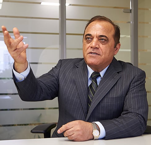
Javad Ashjaee (Photo: Javad GNSS)

Javad Ashjaee (Photo: Javad GNSS)

Just like many of you, we at JAVAD GNSS are quickly and actively adapting to the changing times caused by the global COVID-19 pandemic. We recognize that JAVAD plays an important role in many of your operations and in supporting the critical missions of our customers. To that end, we are following best practices to curtail the spread of this virus and protect the well-being of our employees and partners, while ensuring we meet the commitments to you that you have come to expect.

Our primary message today is JAVAD GNSS is Open for Business! Our support team is here and ready to assist you as it always has. Please do not hesitate to contact us.


OXTS

Geoff Besbrode, Product Marketing Executive

We use Skype extensively, to keep in touch with our customers and partners but also for internal conference calls and meetings. There isn’t really a substitute for face-to-face meetings, but Skype is as close as you can get. In terms of communicating with our partners we have very much moved into the digital space. We have instead held webinars using WebEx which have been very well received. We have more planned so watch this space!

We have learned that we can work very well under pressure! With COVID-19 postponing some of our favorite shows we didn’t want to sit back and do nothing. We had to act very quickly and look at other ways of communicating our message. Not only have we as a business been agile enough to do this, despite working remotely, our channel partners have really taken on board what we’ve been trying to achieve and helped us exceed our goals.

Don’t use COVID-19 as an excuse to rest on your laurels. Take it as an opportunity to do some of the things that you otherwise wouldn’t have done.


Parker LORD

Elena Shapiro, Marketing Manager

To collaborate remotely, a safe distance from each other, we use video messaging (MS Teams) with team(s) daily, as well as Confluence (engineering documentation) and Jira (task management) for remote collaboration.

Much of our team is able to continue efficient operations while working remotely. Collaborating with our customers has always been a service we offer – which, we believe, leads to better product performance and reliability. This pandemic has pushed the majority of the country/world into remote working. While we aren’t able to be in person with customers, accessible remote tools and collaboration help us continue to provide hands-on customer service, without actually using our hands.

Parker LORD designs and produces MicroStrain inertial sensors that are used in robots that aid in delivery, mapping, and surveillance activities. Our inertial measurement units (IMU) and inertial navigation systems (INS) are designed to allow quick time-to-market development. We offer IMU/INS integration with our recently updated Robot Operating System (ROS) drivers for ease of use. By using our sensors, we have reduced development time while also offering top performance and competitive pricing. There are different levels of inertial sensors based on the performances available depending on the application being used.

As the need for measurement and navigation solutions increase with the demand for delivery, safety and automated robotic monitoring, our new 3DMGQ7-GNSS/INS dual antenna RTK-enabled INS provides next level performance with integrated custom IMU, dual integrated RTK-capable multi-constellation GNSS receivers, integrated barometric pressure sensor, and magnetometer. Beyond the integrated sensors the GQ7 offers hardware support for wheel odometry and API support for external velocity sensor measurements. This sensor has been designed for use in markets such as beyond visual line of sight (BVLOS) unmanned aerial vehicles (UAV), unmanned vehicle navigation, legged robots, and autonomous vehicles. It’s an all-in-one system solution (GNSS-INS + RTK + SensorCloud RTK).

Get ready for the robot revolution. There was momentum in that direction before, in areas such as delivery, recon and mapping. Acceptance of these technologies will only increase now and in the future.


Racelogic

Julian Thomas, Managing Director

Julian Thomas, Managing Director. (Photo: Racelogic)

Julian Thomas, Managing Director, Racelogic

Racelogic, the company behind LabSat GNSS simulators, is based in Buckingham, UK. Like many companies, we are adjusting to new ways of working and remote collaboration. With the majority of our 100 staff now working from home, I have few concerns about their ability to adapt and am confident that the outcome will be one of success. However, I am also aware that the paths taken over the coming weeks or months are unlikely to be without a few bumps in the road.

I am hearing reports from all corners of Racelogic about how staff are dealing with these unprecedented circumstances. For example, Katie Harland, our LabSat Support and Applications Technician, is continuing to support our customers from home. However, without a rooftop antenna on her building she has had to be a little inventive about how she gains a live satellite feed to record test scenarios. Her solution was to mount an antenna on a ground plate devised from the lid of a biscuit tin and set it on her garden wall. An effective solution, but one that is not straight forward when you are 5’2” and the garden wall is 7’ tall.

I am also noticing changes to what a “normal” day at work now looks like. With so many staff working remotely I find myself walking through the office and instead of checking on project progress I am rebooting computers, connecting equipment, accessing server files, and generally servicing those who are working remotely. I think it is easy to fall into the trap of obsessing about perfecting remote working. I don’t think you can go too far wrong if you focus on the things you can do, even if you need a ladder to get there.


Septentrio

Jean-Marie Sleewaegen, System Architect

Editorial Advisory Board Member

Jean-Marie Sleewaegen

Jean-Marie Sleewaegen

During these challenging times, Septentrio continues to be operational and to serve its customers. We have taken measures to ensure health and safety within the company. Most of my colleagues and I are working from home, while manufacturing has been divided into two shifts to guarantee continuity and provide the safest possible working conditions. Although international travel is suspended for the moment, we continue to have regular meetings via phone or web with our partners, customers and prospective clients.

This virus is forcing us to rethink the way we work and interact. As we adjust to the new situation, we are finding ways to continue working with as little disruption as possible, leveraging the efficient communication networks and remote-control solutions available to us today. Along the way we might even discover new more efficient and environmentally friendly ways of working.

In addition to ensuring employee safety, Septentrio is also dedicated to help fight the virus by providing reliable high-accuracy positioning solutions to technologies that are making a difference. For example, aerial drones have been used by police in Europe to announce new government regulations in public places and to scope out large areas for public gatherings. To ensure public safety it is vital that the sensors aboard these aerial drones, such as their positioning receivers, are robust and reliable even in challenging conditions.

Septentrio receivers have already proven themselves in the field by providing reliable accurate positioning for safety-critical projects such as the senseFly eBee mission to map out the spread of infectious disease. Matternet delivery drones fly over busy cities to avoid traffic and deliver blood samples for testing faster.

Other delivery drones such as Zipline and Wing are expected to ramp up speed with the increase of automation required to fight the coronavirus. In the European Union and the United States regulations around drone use are stricter than in China and thus the full potential of drones is not yet realized to its maximum.


Spirent Federal

Ellen Hall, President and CEO

Editorial Advisory Board Member

Ellen Hall

Ellen Hall, CEO, Spirent Federal

Since our inception, a few of our employees have worked from home due to traffic issues, work/home responsibilities, or simply geographical location issues. Over the years, we decided as a company not only that this was working very well, but that everyone who could work from home should be allowed to have the same privileges. In the past two years, we have allowed everyone to work from home, only requiring to come into the company offices those who must be in a lab or for security reasons. Everyone has a laptop computer and remote access to files. We use Zoom, email, and cell phones to communicate with each other and our customers.

When the recommendations from the CDC and the President of the United States were issued to work from home, we were already doing this, so there were no adjustments needed. Those that must work in the lab are practicing social distancing and working on alternate days in some cases.

When we first contacted our customers to attempt visits, we were told that they were not receiving visitors and that it was going to take a few days or weeks to get everyone outfitted with laptops and other technology to continue working from home. We were a bit surprised to learn that others were going through this as we were not having any of these issues.

This crisis has taught us that being prepared and trusting our team to work independently pays off when we really need it. Everyone is being a little extra patient, kind, and understanding. We are seeing this general compassion outside of the office as well and we hope that this has a lasting effect on the world.


Topcon Positioning Group

Jackie Ferreira, Director of Corporate Communications

We are fortunate in that our team is well-versed in online collaboration software, including teleconferencing and online digital asset management systems. We are leveraging tools such as those to keep productive in this crisis.

We are working very well together via safe distancing practices. Our employees around the world are staying active with ongoing conference calls across multiple time zones. Our primary concern is the health and safety of everyone we interact with and we continue to be impressed with how all involved have responded.

Topcon operates with a primary goal of the health and safety of its employees, customers, and suppliers and in accordance with applicable state and local orders, including social distancing requirements. To this end, we provide on-going guidance from the World Health Organization (WHO) and Center for Disease Control (CDC) to our employees to support their health in these critical times.

We encourage compliance with applicable governmental orders concerning their ability to continue to operate, with the understanding of roles within the critical infrastructure supply chain.

We are dedicated to supporting our customers at this critical time and have specific teams working to meet demands to the best of our ability.

Our relationships with our customers and partners are important to us. Topcon strives to work closely together with our partners to protect the industries we serve and accelerate the economic recovery needed in light of the current world crisis. Together we can serve as a beacon of cooperation and commitment to successfully weather these unusual times.


Unicore Communications

Jingbo Gao, Marketing Director, Unicore Communications

Jingbo Gao, Marketing Director

Jingbo Gao, Marketing Director

The outbreak of COVID-19 started around the Spring Festival, and strict control measures to stop the spread of the virus were taken even before the holiday ended. Unicore postponed the return-to-job date by one week and encouraged working from home, except for the key R&D and ST engineers, who cannot perform verification, testing, or debugging outside the labs. However, even then strict social distancing measures were guaranteed. As of February 10, Unicore’s return-to-work rate was more than 80%, with nearly 40% of the employees doing it from the office, while now nearly 90% of Unicore’s labor force is back to normal working mode. Thanks to the 4G networks, fast mobile and Web communications, as well as cloud computing technologies, we were able to easily organize video conferencing, online meetings and group messaging.

Our R&D and product delivery were slightly affected by the COVID-19 due to the delays at some supply plants. However, Unicore has a well-run and organized inventory management system, so most of the orders can be fulfilled on time.

Some of Unicore’s clients use drones to perform disinfectant spraying and logistics transportation, which help to ensure an uninterrupted supply of food and goods. Other clients make intelligent and autonomous sweepers that reduce the need for manual labor and keep the workers safely at home. In order to avoid personal injury, infection and transmission in epidemic areas, drones and/or unmanned vehicles with GNSS high-precision positioning technology have been used for cleaning and disinfection, supplies delivery, and aerial photography in engineering construction.

Publicerad den Lämna en kommentar

How to prepare and organize a fleet during the COVID-19

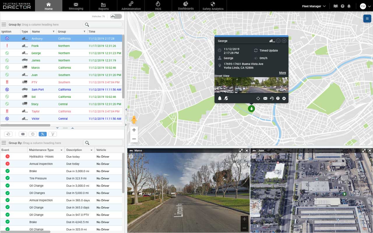
Full Fleet View in the Director program. (Photo: Teletrac Navman)

Full Fleet View in the Director program. (Photo: Teletrac Navman)

By Marco Encinas, Senior Product Manager, Teletrac Navman

In times of global crisis, the world relies on the trucking industry to transport essential items across the country. From medical supplies to restocking the shelves at local grocery stores, truck drivers play an integral role in maintaining the supply chain.

To keep these essential items moving during the COVID-19 crisis, the U.S. Department of Transportation (DOT) has suspended most of the Hours of Service (HOS) regulations for trucks that are transporting these essential goods.

Commercial truck drivers have had their driving hours extended from 11 to 14 hours depending on the goods being carried. With so much going on and so many depending on trucking and freight transportation organizations during this global crisis, fleet managers and owners need to be extremely organized to handle current and future industry needs.

With that in mind, here are a few ways in which you can keep track of your fleet during a time of heightened demand and uncertainty.

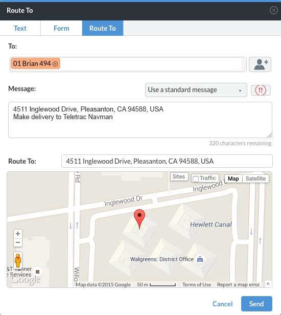
The "Route to" feature in Director. (Photo: Teletrac Navman)

The “Route to” feature in Director. (Photo: Teletrac Navman)

Communication is key

The visibility that essential telematics technology brings can be incredibly helpful. Being able to stay in constant communication with your drivers via messaging and dedicated contact forms — as well as knowing their locations at all times — allows fleet managers to make informed decisions. With things being so hectic right now, knowing where your assets are, who is available for the next load, who is nearest to the depots, and who has encountered longer detention times is critical in a time when efficiently maintaining your fleet on the road is more important than ever.

Most likely due to shelter-in-place orders reducing the traffic overall, many of the states experiencing the highest level of COVID-19 spread are seeing a reduction in travel times for drivers. According to the American Transportation Research Institute (ATRI), freight trucks are clocking faster times overall in these areas, particularly in regularly congested areas.

That being said, because of additional route changes, border regulations and detention delays, freight is taking much longer to transport. Having access to accurate telematics and open lines of communication with drivers will be key in planning and tracking routes.

Documentation should continue

While logs are not mandatory to be kept while under the Federal Emergency Declaration, continuing to make notes and annotate the daily log with the reason for non-compliance is a good practice. This will make sure that logs are current when the Emergency Declaration is lifted. It’s a good idea to integrate a route planner or add-on the service if it isn’t included by your telematics provider to facilitate the planning of loads and tasks. With so much on the fleet manager’s plate and the additional hours drivers are logging, any opportunity for automation should be embraced.

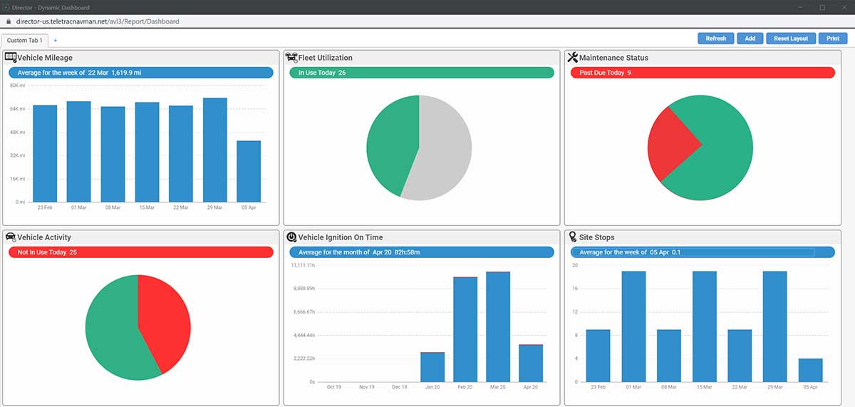
The Dynamic Dashboard of Director. (Photo: Teletrac Navman)

The Dynamic Dashboard of Director. (Photo: Teletrac Navman)

Driver safety

For all fleet managers, the safety of your drivers should be the top priority. DOT HOS regulations are there for a reason. The guidelines, of course, are there to make sure that drivers are not being overtaxed, reducing the possibility of accidents. Giving your team ample time to rest before taking the next load is imperative.

And while its required that drivers receive at least 10 consecutive hours off if they let their company know they need immediate rest, they may be inclined to push themselves given the current situation, feeling a responsibility to their fleet manager and the community at large.

Plus, with people practicing social distancing, it’s likely there will be an uptick in eCommerce purchases, adding additional strain to fleet capacity. A fleet tracking tool will allow managers to review driver’s time, how often they have completed a 14-hour shift, and allow for properly scheduled rest periods to avoid exhaustion and potential accidents.

Tracking rig maintenance

While drivers are putting in the extra miles, so are their rigs! Keeping track of oil changes, tire rotation and other regular maintenance items can keep your drivers and trucks safely on the road. While you may think a global crisis is not the time to stop for regular maintenance, these quick care items are much easier and more cost effective to complete than larger complications they could cause going unaddressed.

An oil change can help engines run more efficiently and reduce a fleet’s cost per mile. Taking time to examine tires could reveal a small leak or puncture which could lead to a popped tire on the road, leaving your driver stuck for hours or even cause them to lose control of the truck from the blowout. Addressing these regular maintenance items will boost efficiency and save time in the long run.

Invest in add-ons

During times of global crisis, the supply chain can change at a moment’s notice. Add-ons such as a brokerage provider integration can help keep the lines of communication open with your customers and help you keep track of where the loads are and when they will arrive. With demand high, and lives on the line while carrying freight like medical supplies, these up-to-the-moment notices can be key in providing your team and customers with the proper support.

Driving demand

There’s no doubt about it: the trucking industry is a key player in combating this global crisis. Delivering everything from medical supplies, to food to other eCommerce purchases for those in quarantine, the country is demanding quite a bit from our fleets.

By staying organized and using helpful telematics tools, fleet managers and owners will be able to meet this challenge with the knowledge they need to make smart decisions. Staying in constant communication with drivers and customers will also help manage expectations and make sure everyone is on the same page.


Marco Encinas, Senior Product Manager at Teletrac Navman, plans the product strategy and roadmap releases globally for all of Teletrac Navman’s software platforms. He gains industry insights from customers, integration partners and R&D to improve current Teletrac Navman product features and tools, and drive development of new product requirements. Before joining the Teletrac Navman team, Encinas planned product strategy and roadmap releases for both commercial and consumer product lines, developed sales training tools and product curriculum at Magellan GPS and Mitsubishi.

Publicerad den Lämna en kommentar

Russia-CIS navigation plan emphasizes GNSS, Loran, inertial

Representatives from 11 nations met in Moscow and agreed to a “Radio Navigation Development Plan for Participating Commonwealth of Independent States for 2019 to 2024.” The plan is more than 100 pages. The Russian version is here; a version in English produced by Google Translate can be found here.

The plan documents existing systems, recent accomplishments and user needs, as well as the upgrades and changes required to meet those needs.

The plan highlights Russia’s concern with GNSS signal disruption and seems to confirm a mobile terrestrial PNT capability, likely for military use, that has received little public attention.


Note on Translation and Terminology: The copy of the plan we found was in Russian. We used Google Translate to create an English version. One translation issue that we noticed was several variations of the way the Russian terrestrial Loran PNT system is described. The Russian Loran system is named “Chayka,” literally “Seagull” in English. References in the translated version to “Chaika,” “Loran,” “Laurent,” “Seagull” and “Tropic” are all some version of “Loran.”


User requirements

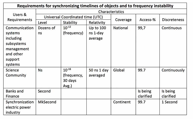
The plan provides a discussion of user requirements for each mode of transportation and for timing users. The table, translated from Russian to English, is below:

Source: Radio Navigation Development Plan for Participating Commonwealth of Independent States for 2019 to 2024

Click to enlarge. (Source: “Radio Navigation Development Plan for Participating Commonwealth of Independent States for 2019 to 2024”)

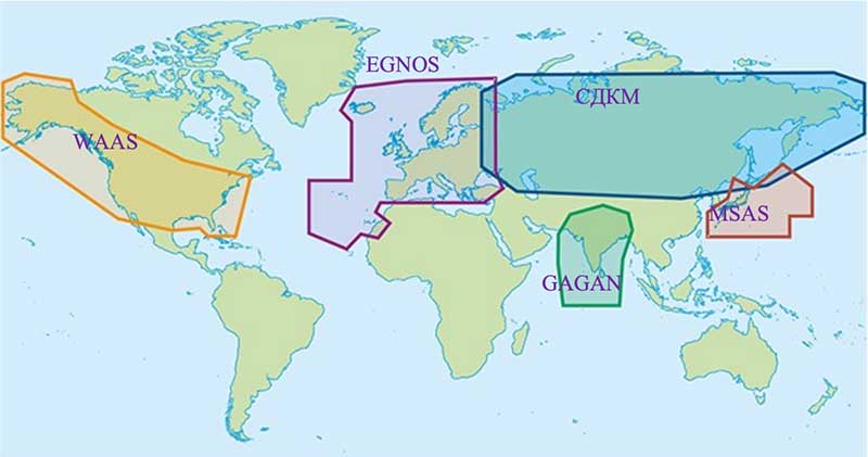
Currently, the Russian/Commonwealth of Independent States (CIS) domestic PNT covers 14% of the Earth’s land mass, compared to 6.6% for the United States.

Map: Radio Navigation Development Plan for Participating Commonwealth of Independent States for 2019 to 2024

Click to enlarge. (Map: “Radio Navigation Development Plan for Participating Commonwealth of Independent States for 2019 to 2024”)

Interference

The plan discusses interference, listing 13 operational electronic systems with emissions that could impact reception. It also lists recommendations to counter interference, including creating a system to monitor GNSS frequencies and identify disruptions, using multiple GLONASS frequencies, and integrating GLONASS, GPS and terrestrial systems within users’ receivers.

Loran and GNSS

Russia’s version of Differential GNSS and Eurofix is done using Loran towers and signals. Advantages of this include covering a large area at a relatively low cost; improved channel uptime and availability; data transmission in urban and mountainous areas; and GLONASS and GPS serving as backups for each other.

The plan also points out that Loran and GNSS are mutually supportive in other ways, saying “GNSS location determinations can be used to calibration of readings RSDN and compensate for errors due to the propagation of radio wave. In turn the data Laurent-C/Seagull can be used to monitor the integrity of satellite RNS.”

Mobile Loran/Scorpio

The document also describes Russia’s “Scorpio” or “Skorpion” as ongoing Ministry of Defense research and development modernization program.

It also describes Scorpio as a mobile form of the Tropic-2P variant of Seagull/Loran.

“In the period until 2020, a planned replacement of mobile long-range radio navigation systems ‘Tropic-2P’ to the information system coordinate-temporal support ‘Scorpio,’” the document stated. “As part of the complex equipment, there are local control and correction stations, which can significantly improve the accuracy of determining coordinates consumers.”

Moving forward

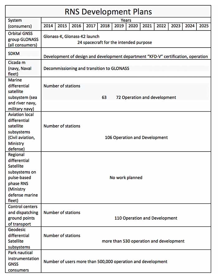
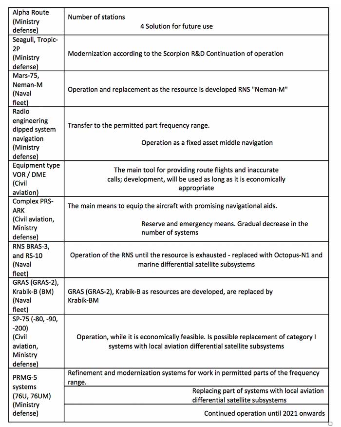
Finally, the document includes a table of 19 different navigation systems maintained by the government and the plan for each.

Source: Radio Navigation Development Plan for Participating Commonwealth of Independent States for 2019 to 2024

Click to enlarge. (Source: “Radio Navigation Development Plan for Participating Commonwealth of Independent States for 2019 to 2024”)

Source: Radio Navigation Development Plan for Participating Commonwealth of Independent States for 2019 to 2024

Click to enlarge. (Source: “Radio Navigation Development Plan for Participating Commonwealth of Independent States for 2019 to 2024”)

Publicerad den Lämna en kommentar

Bluesky launches international MetroVista city mapping service at Intergeo 2019

About the Author:

Allison Barwacz is the digital media manager for North Coast Media (NCM). She completed her undergraduate degree at Ohio University where she received a Bachelor of Science in magazine journalism from the E.W. Scripps School of Journalism. She works across a number of digital platforms, which include creating e-newsletters, writing articles and posting across social media sites. She also creates content for NCM’s Pit & Quarry magazine, Portable Plants magazine and Geospatial Solutions. Her understanding of the ever-changing digital media world allows her to quickly grasp what a target audience desires and create content that is appealing and relevant for any client across any platform.

Publicerad den Lämna en kommentar

ION 2020 Joint Navigation Conference rescheduled over COVID-19 concerns

Logo: ION

The Institute of Navigation’s (ION) 2020 Joint Navigation Conference (JNC) has been rescheduled for Sept. 8-11 at the Northern Kentucky Convention Center.

The U.S.-only For Official Use Only sessions will be hosted at the Northern Kentucky Convention Center in Covington, Kentucky, and the U.S.-only secret sessions will be hosted at the Air Force Institute of Technology in Dayton, Ohio.

According to ION, the rescheduled conference will host the original program, which was scheduled to take place in June.

“We are aware of the importance of this community of dedicated public servants meeting in an environment where they can effectively collaborate, exchange research, and demonstrate technology,” said Lisa Beaty, executive director for ION. “The current global climate made our ability to hold this conference in June unlikely, and we needed to provide an alternative opportunity for all our stakeholders.”

Those scheduled to present at JNC 2020 will receive emails from ION asking them to respond electronically to confirm the rescheduled dates and times of their presentations. Those who have registered to attend will receive an email from ION letting them know what their options are.

Publicerad den Lämna en kommentar

Dashboard graphs those working from home during COVID-19

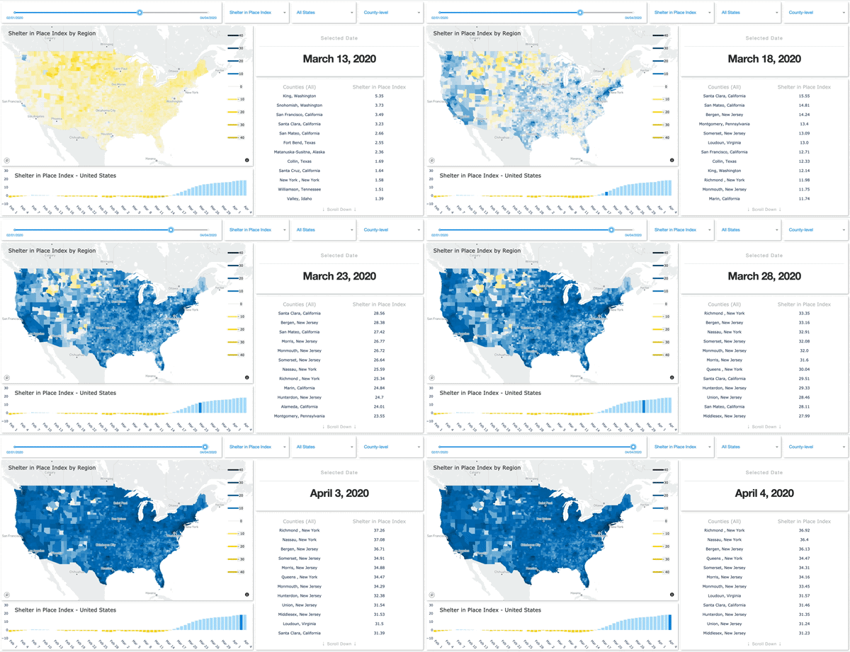
SafeGraph has launched a Shelter in Place Dashboard that enables users to visualize stay-at-home behavior for every county in the United States.

Image: SafeGraph

Image: SafeGraph

SafeGraph has also created and released two new datasets:

  • Weekly foot-traffic patterns
  • Social Distancing Index

The data is being provided at no cost to non-commercial entities.

“We currently have over 550 researchers, non-profits and government agencies in a Slack group using these new datasets,” said Evan Barry, vice president of marketing, SafeGraph. Academic and industry research articles based on the data are now published on the SafeGraph site.