Publicerad den Lämna en kommentar

When will Russia attack GPS? Interview with former CIA analyst George Bebee

George Beebe

George Beebe

In mid-November, Russia destroyed a retired satellite with a ground-based anti-satellite (ASAT) weapon. This created significant debris, which endangered other assets in low-Earth orbit, including the International Space Station (ISS). Two Russian cosmonauts were serving on the seven-person ISS crew at the time.

Two weeks later, Russia followed up the ASAT demonstration with the boast that they could destroy all 32 Global Positioning System satellites at once, blinding the U.S. and NATO.

Based on the ASAT demonstration and unclassified reports from the U.S. Director of National Intelligence, it is pretty clear that Russia can destroy all, or at least most, GPS satellites in one go.

What is less clear, is whether Russia would really do that.

To find out, Dana A. Goward spoke with George Beebe, who once served as the Central Intelligence Agency’s top analyst for Russia and Eastern Europe. He is now the director of programs at the Center for the National Interest, a center-right think tank.

Dana A. Goward: Russia’s threat to destroy GPS was made shortly after they destroyed an old satellite in space. What do you make of that demonstration, and all the dangerous debris it created?

George Beebe: Well, they were clearly sending a message — several messages, in fact. First, of course, that they have the ability to destroy satellites in space. This is part of a larger narrative they want to tell — that they are a world power which must be reckoned with. And it is no coincidence that this was done while they were amassing troops along Ukraine’s borders.

Another message is that they know the U.S. and Europe are very dependent on space, and we are vulnerable there.

DG: But the space debris will threaten satellites and people in low-Earth orbit for years to come. That seems to be reckless and counter to their own interest.

GB: While others see that as reckless and irresponsible, Russian officials almost certainly see it as an expression of resolve. That was actually another message. They were saying, “We are willing to endanger our own equipment and people.”

Translate that to their concern about keeping Ukraine from joining NATO and otherwise falling into the West’s sphere of influence. It might be, “We are willing to accept the pain in order to keep Ukraine from leaving our orbit.”

Unfortunately, I am not sure most Western leaders picked up on the “We are resolved” message.

DG: Attacking GPS would be a huge, devastating and dangerous move, though. How could things get so bad they would do that?

Cover: Thomas Dunne Books

Beebe is the author of The Russia Trap. (Cover: Thomas Dunne Books)

GB: Russia sincerely believes it is generally threatened by the West, and specifically by NATO.

Since the fall of the Soviet Union, they have seen their global influence recede, and Western influence on their borders greatly expand. Some of their neighbors have joined NATO. Others, like Ukraine, have not, but would like to eventually come under the NATO umbrella. For the Kremlin, this is unacceptable. It is akin to what Soviet missiles in Cuba were for the United States.

Over the last decade and a half, Putin has rebuilt the Russian military. He is now looking to draw lines in the sand for the West to not cross.

At the same time, the West feels threatened by Russia. Hitler’s aggression and refusal to be appeased by territorial concessions is standard reading in every Western history class. American and European leaders feel compelled to hold the line and not give into what they see as Putin’s territorial ambitions.

This is a very dangerous situation as both sides see themselves acting defensively and the other acting aggressively.

DG: I guess it is much easier to justify something to yourself and your compatriots if you think you are only acting in self-defense.

GB: Exactly. The problem comes when one side does something in self-defense and, in response, the other side feels compelled to do something as well. This can spawn an escalating tit-for-tat that spirals out of control into a bigger conflict no one wants.

DG: The West is imposing economic sanctions. At least that is harder to interpret as aggressive.

GB: Before World War II, the U.S. imposed severe economic sanctions on Japan in response to its expansionist moves in Asia. The sanctions were so severe that they were crippling and threatened to bring down Japan’s military government. The week before Pearl Harbor, the Japanese delivered a diplomatic note to the United States saying the sanctions amounted to an act of war. So, economic sanctions are not always an absolutely safe route.

DG: Do you think Russia would ever really attack GPS? And how might that go down?

GB: It depends on how backed into a corner they feel. They certainly know that our military and our homeland are very dependent on GPS, and we have no real alternative in place. It doesn’t help that they are much less dependent on GLONASS and have an alternative for when signals from space are not available.

So, they can definitely do more harm to us than we can to them by interfering with navigation satellites.

It would take a lot to goad them into physically attacking GPS satellites. That would be an irreversible step they undoubtedly understand could lead to all-out war.

Far more likely would be a cyber-attack on the systems controlling the GPS constellation. Such an attack could be harder to attribute to them. It could also be reversed if they got what they wanted.

I could also see them jamming GPS and Galileo signals across Europe and the United States as part of an escalated conflict. Russian forces excel at electronic warfare, and the jamming could easily be turned off once they achieved their goals, or if things seemed to be getting out of hand.

Photo: Stanislav Ostranitsa/iStock/Getty Images Plus/Getty Images

Photo: Stanislav Ostranitsa/iStock/Getty Images Plus/Getty Images

Publicerad den Lämna en kommentar

Launchpad: Mapping software, MEMS accelerometers

A roundup of recent products in the GNSS and inertial positioning industry from the February 2022 issue of GPS World magazine.


OEM

GNSS Receiver

For tracking, telematics

Photo: u-blox

Photo: u-blox

The LENA-R8 GNSS receiver is based on the u-blox M10 platform. The compact module balances cost and performance with a single antenna and primarily targets customer deployments in the Europe, Middle East, Africa, Asia, and South America regions. Designed for tracking and telematics, the module series was designed to minimize material costs and data charges. The LENA-R8 supports a broad range of frequency bands with 2G fallback, providing maximum roaming coverage for global tracking applications using a single stock keeping unit (SKU).

U-blox, u-blox.com

Helical Antenna

For UAVs and other applications

Photo: Tallysman

Photo: Tallysman

The low-profile triple-band HC997EXF embedded helical GNSS antenna features eXtended Filtering (XF). It is designed for precise positioning, covering the GPS/QZSS-L1/L2/L5, GLONASS-G1/G2/G3, Galileo-E1/E5a/E5b, BeiDou-B1/B2/B2a, and NavIC-L5 frequency bands. It also covers regional satellite-based augmentation systems (WAAS, EGNOS, MSAS, GAGAN) and L-band correction services. It is packaged in a light (11 g), compact form factor (60 x 25 mm). Its precision-tuned, high-accuracy helical element provides an excellent axial ratio and operates without a ground plane, making it suitable for lightweight unmanned aerial vehicle (UAV) navigation and a wide variety of precision applications.

Tallysman Wireless, tallysman.com

A-PNT Card

High precision for defense

Photo: Spectranetix

Photo: Spectranetix

The SX-124 ruggedized 3U OpenVPX high-performance positioning, navigation and timing (PNT) card can provide timing and positioning information in a GPS-denied environment through sensor fusion. It is designed for highly integrated systems with a requirement for the U.S. Army’s C5ISR Modular Open Suite of Standards (CMOSS) and alignment with the Open Group Sensor Open Systems Architecture (SOSA) technical standard. The SX-124 can accept external sources or use its onboard GNSS receivers as reference inputs for timing and positioning data. The positioning data can be fused with internal and external inertial measurement units.

Spectranetix, spectranetix.com

MEMS Accelerometers

Radiation tested for space

Photo: Silicon Designs

Photo: Silicon Designs

The Model 1527 series is a family of miniature, radiation-tested, tactical-grade micro-electromechanical (MEMS) accelerometers. Offered in three full-scale acceleration ranges — ±10 g, ±25 g and ±50 g — the series is designed to support a variety of critical space electronics testing requirements, including those of spacecraft, satellites and CubeSats. Their small bias and scale-factor temperature coefficients, excellent in-run bias stability and zero cross-coupling make the Model 1527 series particularly well-suited for spacecraft electronics testing applications requiring low power consumption (+5 VDC, 6.5 mA), low noise, long-term measurement stability in –55° C to +125° C environments, and performance reliability under intermittent radiation exposures.

Silicon Designs, silicondesigns.com

Automotive Receiver

Guidance for advanced driver assistance systems

Photo: STMicroelectronics

Photo: STMicroelectronics

The STA8135GA automotive-qualified GNSS receiver is designed to deliver the high-quality position data needed by advanced driving systems. Part of the Teseo V family, the STA8135GA integrates a triple-band positioning measurement engine. It also provides standard multi-band position-velocity-time (PVT) and dead reckoning. The multi-constellation receiver delivers raw information for the host system to run any precise-positioning algorithm, such as PPP/RTK (precise point positioning/real-time kinematic). The receiver can track satellites in the GPS, GLONASS, BeiDou, Galileo, QZSS and NAVIC/IRNSS constellations.

STMicroelectronics, st.com


Surveying & Mapping

Software Upgrade

Improvements support photos, 2.5D data capture

Photo: 1Spatial

Photo: 1Spatial

Survey application 1Edit now has increased support for photos and 2.5D data. 1Edit 3.1 allows users to attach feature photos, including automated geotagging, which enables surveyors to visualize assets and fine tune observations. Also included are new validation functions and improved handling for heights (2.5D data), typically useful for detailed asset and land-management surveys. Enhanced styling, including bitmap fills and dashed lines, make it easier to identify and classify different asset types during surveys. Additional control of editable layers and fields provides protection for non-editable data and protects the data quality. Significant improvements to rendering of thematic mapping enhances the speed and fluidity of the intuitive user interface.

1Spatial, 1spatial.com

Mapping Software

Map-making functionality improved

Photo: Golden Software

Photo: Golden Software

The latest version of Surfer surface mapping software has improved map-making functionality and data exporting capabilities. Surfer is used by more than 100,000 people worldwide, many involved in oil and gas exploration, environmental consulting, mining, engineering and geospatial projects. It provides fast and powerful contouring algorithms, enabling users to model data sets, apply an array of advanced analytics tools, and graphically communicate the results. Frames now have outlines and background fill colors to make them easier to read when placed on top of maps and attribute data can now be exported as numeric data.

Golden Software, goldensoftware.com

RTK/PPP Device

Multi-sensor fusion on a single board

Photo: ANavS

Photo: ANavS

The Multi-Sensor (MS-) RTK/PPP device is a turnkey system easily integrated into surveying applications. The module includes up to three multi-frequency, multi-GNSS (GPS + Galileo + Glonass + BeiDou) receivers, a MEMS IMU, a barometer, a CAN interface for reception of vehicle data (wheel odometry and steering angle), and an LTE module for reception of RTK/PPP corrections. ANavS sensor fusion performs tight coupling of all sensor data with an Extended Kalman Filter (EKF). Various interfaces can connect additional sensors (such as camera or lidar) or output position information.

ANavS, anavs.com

Auto Mapping

Increases lane-level accuracy

Photo: Asensing

Photo: Asensing

The HD-MapBox integrates high-precision map data based on high-precision positioning. Fusing data from a GNSS receiver, IMU, ADAS camera, vehicle dynamics and HD maps, the HD-MapBox can achieve a lateral error of less than 8 inches (0.2 meters) and a longitudinal error of less than 6.5 feet (2 meters) with a 95% confidence interval, providing an accurate reference for highway pilots and automated valet parking. Even if both GNSS and lane line detection are not available, the HD-MapBox can still enable vehicles to keep inside the lane for at least a quarter mile (400 meters).

Asensing, asensing.com

Positioning System

Adds location data inside buildings

Photo: Esri

Photo: Esri

Esri ArcGIS IPS is an indoor positioning system that adds a blue dot to indoor maps, enabling users to locate their current position inside a building in the same way GPS enables outdoor location indicators. It uses an alternative technology to enable real-time positioning and navigation inside buildings. It also provides live location sharing and tracking, location data capture and analytical insights. ArcGIS IPS is available for users of ArcGIS Indoors, an indoor mapping system for smart building management, and ArcGIS Runtime SDKs, which enable the indoor positioning capability in custom-built apps.

Esri, esri.com

Publicerad den Lämna en kommentar

GNSS + sensors have transformed surveying

Photo: payamona / iStock / Getty Images Plus / Getty Images

Photo: payamona / iStock / Getty Images Plus / Getty Images

Matteo Luccio

Matteo Luccio

In this issue’s cover, a man with a backpack lidar unit, a GNSS receiver and a tablet computer is surveying in a complex and challenging urban setting. That same lidar unit also can be mounted on a UAV. One of the contributors to this month’s cover story describes the role of aerial photogrammetry in the architecture, engineering and construction (AEC) industry. Satellite navigation, remote sensing, mapping software, a great variety of platforms, and ever more powerful handheld computers — those are the key ingredients in today’s ecosystem of geospatial technologies. The current generation of surveying equipment has more than halved fieldwork in the past two decades while greatly improving the quality of the data collected.

The AEC industry relies on surveyors to be “a bridge between the existing landscape and the design landscape,” said another contributor to our cover story. Unlike traditional boundary surveying, he explained, surveying for AEC requires consideration of a detailed 3D world. It also involves many more stakeholders and much greater liability.

The tight integration of GNSS, inertial systems, lidar sensors and 360° spherical imagery into mobile mapping systems makes 3D modeling possible and traditional GNSS or optical measurement instruments obsolete. However, while inertial systems are invaluable to bridge brief gaps in the availability and reliability of GNSS signals, they are far from the panacea they are sometimes claimed to be, as Brad Parkinson reminds us in an interview with Dana Goward, also in this issue.

Surveying for AEC requires at least centimeter accuracy. The challenges of surveying in urban settings include urban canyons that occult signals and create multipath, traffic and multiple layers of underground, ground-level and above-ground infrastructure.

Beyond the construction phase, 3D survey data is increasingly used to create digital twins of buildings, which facilitate their operation and maintenance throughout their life cycle and help lower their carbon footprint. Once they have completed an initial survey, surveyors often set control to be used for machine control — the theme of our cover story in next month’s issue.

In this issue we also:

• Inaugurate a “letters to the editor” section to make more room for debate in the GNSS/PNT community on the critical issues it faces.

• Report on a Jet Propulsion Laboratory study of the impact on the ionosphere of the enormous volcanic eruption in Tonga and the beginnings of a GNSS-based early warning system for natural hazards.

• Continue our series of articles on GNSS constellations, with an update from Japan’s QZSS constellation.

• Feature three studies: one on real-time simulator testing using an NMEA data stream, one on the first transmission of L1C/B signals by QZSS, and one on self-driving cars in major metropolitan areas.

All these advances, however, are threatened when GPS is threatened. Earlier in the month, three members of our editorial advisory board comment on the recent threat to GPS satellites by the Russian government.

Matteo Luccio | Editor-in-Chief
mluccio@northcoastmedia.net

Publicerad den Lämna en kommentar

ION GNSS+ 2022 abstract deadline is March 4

Photo: ION

Photo: ION

Abstracts for the ION GNSS+ 2022 show, “GNSS + Other Sensors in Today’s Marketplace,” are due March 4.

The ION GNSS+ conference will take place September 19-23  at the Hyatt Regency Denver at Colorado Convention Center in Denver. The show will also include a virtual option.

The 2022 conference will bring together international leaders in GNSS and related positioning, navigation and timing fields to present new research, introduce new technologies, discuss current policy, demonstrate products and exchange ideas.

The two tracks covered during the conference will be commercial and policy tracks and research tracks.

The commercial and policy tracks will include high performance and safety critical applications, status and future trends in GNSS, and mass market and commercial applications. The research tracks will include multisensor and autonomous navigation, algorithms and methods, and advanced GNSS technologies.

Interested parties may submit their abstracts at https://www.ion.org/gnss/call-for-abstracts.cfm.

Publicerad den Lämna en kommentar

Northrop Grumman to equip Marines with next-gen targeting devices

Image: Northrop Grumman

Image: Northrop Grumman

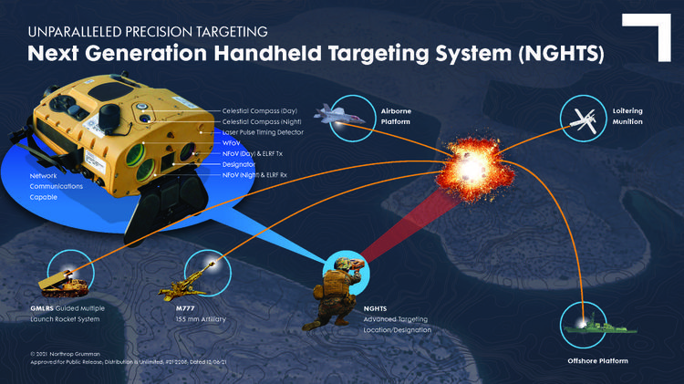
The U.S. Marine Corps has selected Northrop Grumman to provide the Next Generation Handheld Targeting System (NGHTS), a compact device that provides precision targeting and is capable of operation in GPS-denied environments.

The laser-based device will give marines an enhanced capability to identify and designate targets from extended ranges.

“NGHTS will significantly enhance the ability of marines to identify ground targets under a wide range of conditions,” said Bob Gough, vice president, navigation, targeting and survivability, Northrop Grumman. “Connected to military networks, NGHTS can provide superior situational awareness and accurate coordinates for the delivery of effects from beyond the line of sight.”

Northrop Grumman’s NGHTS is capable of performing rapid target acquisition, laser terminal guidance operation and laser spot imaging functions. Its high-definition infrared sensors provide accuracy and grid capability over extended ranges. Additional features include a high-definition color display and day/night celestial compasses.

Publicerad den Lämna en kommentar

ION opens registration for Pacific PNT Conference

Photo: ION

Photo: ION

ION’s Pacific PNT Conference is a global cooperative development of Positioning, Navigation and Timing technology and applications where policy and technical leaders from around the world meet to discuss policy updates, receive program status updates and exchange technical information.

The 2022 conference will be hosted virtually April 11-13 PDT on a complimentary basis for ION members. The conference will include sessions on policy and status updates, performance schedules and plans, plus special challenges affecting Asia-Pacific presented by an elite list of experts representing BeiDou, COSMIC/ FORMOSAT, and QZSS.

A session will broadcast each day at 9:00 a.m. JST / 5:00 p.m. PDT. Live-stream attendees will have the opportunity to participate in virtual question and answer periods through the portal.

To register and view the technical program for this conference, visit https://www.ion.org/pnt/index.cfm.

Publicerad den Lämna en kommentar

UK seeks alternative navigation for weapon systems

The United Kingdom has issued a market exploration document for alternative navigation for weapon systems to support GNSS.

Specifically, UK Defence Equipment and Support (DE&S) and the Defence and Security Accelerator (DASA) want to understand the range of technologies used for commercial positioning and navigation systems. Its main area of interest is to know the location of the weapon during the mid-course phase of deployment, as shown in the figure below, with an accuracy of ±5 meters. Technology guidance to the final target is not part of the scope.

Project focus is location of the weapon during the mid-course phase of deployment with an accuracy of ±5 meters. (Image: UK Defence)

Project focus is location of the weapon during the mid-course phase of deployment with an accuracy of ±5 meters. (Image: UK Defence)

With GNSS vulnerable to jamming and spoofing, the exploration is interested in supporting navigation and positioning technologies, such as:

  • Terrain contour matching (TERCOM): uses a radar altimeter and a digital terrain elevation database.
  • Digital scene matching (DSMAC): matches an onboard image to an imagery database.
  • Inertial navigation systems (INS) or inertial measurement units (IMU): rely on accurate measurements of velocity and time to calculate position.

The market exploration is part of a larger Technology Demonstration Program. The defense agencies recently ran an Innovation Focus Area looking at quantum navigation systems, and selected several proposals for funding.

Quantum technology is not specifically out of scope for this exploration, but the agencies are specifically looking for technologies that could be developed to a testing and trialling prototype within the next three years.

For more information, see the document webpage.

Publicerad den Lämna en kommentar

Applanix User Group Meeting and Conference registration now open

Applanix User Group Meeting logo

Registration has now opened for the Applanix User Group Meeting and Conference, focused on Air and Land solutions, taking place in Fremont, California, Sept. 20-22. Discounted early bird prices will be available until May 1. The conference is also currently accepting speaker proposals.

This meeting will give you the opportunity to hear the latest news from Applanix, take in-depth product training, meet with product and customer support experts, and network with other industry leaders from around the world.

The conference will take place over three days and will have four main goals:

• Deliver an information-filled training experience on all of our software, as well as the APX series of boards, POS products, and the latest developments in the Autonomy field

• Present the new Land Mobile Mapping line of OEM and plug-and-play products

• Give customers and partners an opportunity to share their most recent projects and experiences

• Provide networking opportunities

To register and purchase tickets for the conference or to submit a proposal, visit Applanix’s website.

Publicerad den Lämna en kommentar

Space Tech Expo Europe opens call for speakers

Space Tech Expo Europe logo

Space Tech Expo Europe has opened its call for speakers for the free-to-attend conference to be held November 15-17 in Bremen, Germany.

The conference will focus on the latest advancements in the European and global space industry, including space exploration, in-space manufacturing, launch, system development,  market trends and more.

The conference will take place alongside the leading supplier trade show with hundreds of exhibitors showcasing the latest space technological advancements. The conference provides attendees with the knowledge on the latest developments in European space. Previous speaking companies include: OHB, NASA, ArianeGroup, Airbus Defence and Space, UK Space Agency, ESA and many more.

Proposals for speakers will be accepted through April 11, 2022. To submit a proposal or learn more about the event, please visit the Space Tech Expo Europe website.

Publicerad den Lämna en kommentar

Russia expected to ditch GLONASS for Loran in Ukraine invasion

Russian military doctrine assumes GLONASS and other GNSS will not be available once a battle begins, so will instead turn to Loran-C for navigation

Russian forces are expert at jamming and spoofing GNSS. As a result, military analysts say, Russian military doctrine assumes that signals from space, including it’s own GLONASS and other GNSS, will not be available once a battle begins.

According to the Russia and CIS Radionavigation Plan, the terrestrial Chayka system, a version of Loran-C, is maintained to protect their homeland with navigation and timing services when signals from space are not available. The portable Skorpion system is designed for military use during expeditions to areas where Chayka or Loran is not available, according to western military analysts.

“Fixed Chayka transmission sites operate between 90 Khz and 110 Khz. Power output is typically between 200 and 800 kW with effective ranges over land of about 800 miles and over water of 1,000 miles,” explained Dana Goward, president of the Resilient Navigation and Timing Foundation. He noted that little information is publicly available about the military Skorpion system.

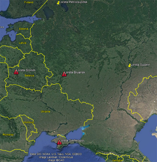
“Three of Russia’s Chayka/Loran stations have Ukraine surrounded,” explained UrsaNav CEO Charles Schue, referring to a graphic he provided GPS World. “They provide ideal coverage and will allow navigation accuracy of between 20 and 50 meters over most of the Ukraine. Upgrading to an eLoran equivalent could give them 5-to-10-meter accuracy, but I am sure the current setup is more than adequate for their purposes at the moment.”

Image: Charles Schue, UrsaNav

Image: Charles Schue, UrsaNav

Schue was the first commanding officer of the U.S. Coast Guard’s Loran Support Unit and the first program manager for the congressionally mandated Loran Modernization and Recapitalization project that was upgrading the U.S. Loran-C system to eLoran. As CEO of UrsaNav, he is helping several countries with Loran-C and eLoran projects.

One of the three surrounding Loran transmission sites is in the Crimea, which Russia invaded and annexed in 2014.

“The primary reason for taking Crimea may have been ensuring access to the ocean,” Schue said, “but it also allowed them to regain control of the Loran transmission site there. This has assured them sovereign terrestrial PNT [positioning, navigation and timing] for the entire region, including the Black Sea.”

A 2017 coverage map from Russia’s Internavigation Research and Technical Centre of Advanced Navigation shows Chayka serving eastern Europe, western Russia, and almost all of the Black Sea.

Image: Russia’s Internavigation Research and Technical Centre of Advanced Navigation

Image: Russia’s Internavigation Research and Technical Centre of Advanced Navigation

Image: Russia’s Internavigation Research and Technical Centre of Advanced Navigation

Image: Russia’s Internavigation Research and Technical Centre of Advanced Navigation