Publicerad den Lämna en kommentar

WORK Microwave joins Digital IF Interoperability Consortium

WORK Microwave DIFI logo

As a new member of the DIFI Consortium, WORK Microwave will help advance the digitization of satellite communication ground technologies

WORK Microwave, a leading European manufacturer of advanced satellite communications equipment, today announced that it has joined the Digital Intermediate Frequency Interoperability (DIFI) Consortium, an independent space-industry group that formed to advance interoperability in satellite and ground-system networks.

As a new member of DIFI Consortium, WORK Microwave joins a growing roster of leading organizations in the space industry committed to bringing innovation to the digital transformation of space, satellite and related technologies.

“With the new space boom and LEO constellations emerging, digitization of the ground segment plays a key role in scalability and sustainability,” said Jörg Rockstroh, director of business development and digital products at WORK Microwave. “Being a prime supplier of satellite communications equipment, WORK Microwave actively supports standardization and other industry-wide efforts to simplify the ecosystem. Joining the DIFI Consortium is an excellent opportunity to help shape the future digitization of the satellite communication ground segment.”

WORK Microwave is an early adopter of new technologies, including digital signal processing, modem infrastructures, optical communication and Q-/V-band equipment. As a long-term contributor to industry standardization, the company has a history of helping advance satellite communication ground technology.

“The DIFI Consortium’s goal is to provide a simple, open, interoperable digital IF/RF standard that replaces the natural interoperability of analog IF signals and helps prevent vendor lock-in,” said Stuart Daughtridge, chair of DIFI Consortium. “We welcome WORK Microwave to the group and look forward to seeing how they will contribute to moving interoperability forward across space networks.”

Publicerad den Lämna en kommentar

EU reacts as Russia severs rocket-launch relationship

Russia’s space agency Roscosmos is suspending cooperation with Europe on space launches from the Kourou spaceport in French Guiana, including future Galileo satellite launches.

As reported by Rueters, Roscosmos chief Dmitry Rogozin said Saturday the action is in response to Western sanctions over Russia’s invasion of Ukraine.

“In response to EU sanctions against our companies, Roscosmos is suspending cooperation with European partners on space launches from Kourou, and is withdrawing its technical staff…from French Guiana,” Rogozin said in a post on his Telegram channel.

Russia’s decision will have “no consequences on the continuity and quality of Galileo and Copernicus services,” EU Commissioner Thierry Breton said in a statement. “This decision does not call into question the continuity of the development of these infrastructures either.”


“We are also ready to act with determination, together with the Member States, to protect these critical infrastructures in the event of an attack.”


“We will, in due course, take all the necessary decisions in response and resolutely pursue the development of the second generation of these two sovereign space infrastructures of the Union,” Breton said. “We are also prepared to act determinedly together with the member states to protect these critical infrastructures in case of an attack, and to continue the development of Ariane 6 and VegaC to guarantee the strategic autonomy with regard to carrier rockets.”

The Galileo program had already planned to shift to using Ariane 6 rockets for satellite launches. The launcher is undergoing the final stages of development, led by prime contractor ArianeGroup.

From 2023 onward, the remaining Galileo Batch 3 satellites will be launched with the new Ariane 62 launch vehicle, a variant of Ariane 6 with two strap-on solid boosters.

The most recent Galileo satellite launch took place on Dec. 5, 2021, using Soyuz launcher VS-26 to carry the first pair of Galileo Batch 3 satellites into orbit. The announcement will delay a Soyuz launch of two more Galileo satellites scheduled for April from French Guiana; a third pair of Galileo satellites was scheduled to launch in autumn on another Soyuz.

Galileo launch 11 from Europe’s spaceport in French Guyana. (Photo: ESA/CNES/Arianespace)

Galileo launch 11 from Europe’s spaceport in French Guyana. (Photo: ESA/CNES/Arianespace)

Publicerad den Lämna en kommentar

Taoglas launches small 9-in-1 GNSS+5G antenna at MWC

Taoglas announced its smallest 9-in-1 combination antenna with dual-band GNSS and high-performance 5G/4G, the Taoglas MA990 Guardian.

Taoglas made the announcement at Mobile World Congress (MWC) Barcelona 2022, which takes place  Feb. 28–March 3; Taoglas is exhibiting at booth #5E32.

The Taoglas MA990 Guardian antenna is a small 9-in-1 combination antenna with dual-band GNSS (L1/L2) and globally supported cellular (5G/4G). It has been designed to support emerging market demand for modules that cover specific 5G/4G bands.

For example, two of its eight cellular MIMO antennas cover from 600 to 6,000 MHz, while another two are optimized for 3,000 to 6,000 MHz to cover high-band 5G and C-band/CBRS applications. The product is designed to operate on all carrier networks globally and is future-proofed to work with latest 5G routers in the market.

Housed in a low-profile, robust, IP67-rated waterproof, adhesive-mount external enclosure, the MA990 is designed for space-constrained, mission-critical applications, including asset and vehicle tracking, first- responder vehicles and high-definition video sources such as surveillance cameras.

The Taoglas MA990 also is highly customizable, including for any variation of antennas below 9-in-1 and the addition of Wi-Fi/single-band GNSS.

Publicerad den Lämna en kommentar

ComNav Technology: Surveying in urban conditions

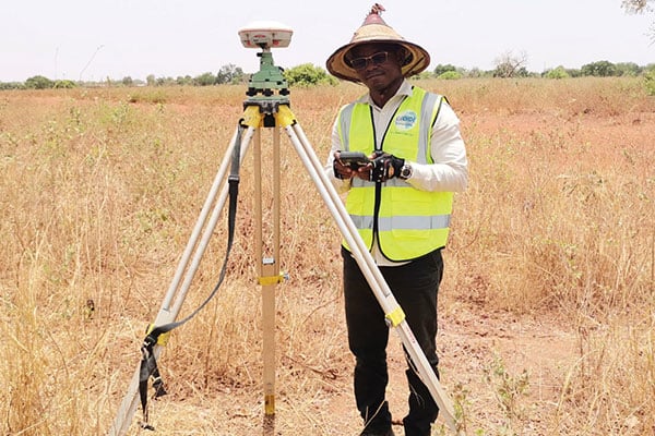
A surveyor in Burkina-Faso surveys the site of a new hospital for infectious diseases. (Photo: ComNav)

Surveyors used ComNav equipment to construct a hospital in Burkina Faso. (Photo: ComNav)

Line of sight to GNSS satellites is sometimes obscured by buildings and trees, which also cause multipath, as does nearby water. These conditions require an RTK receiver with multipath mitigation. Often, surveying must occur on property corners or on uneven ground, where it is hard to place surveying equipment. For these reasons, reliability and accuracy are essential, especially in harsh environments. Ground control points require 1-2mm accuracy and topo surveys 1-2cm accuracy. Surveying for AEC also requires software that processes digital files.

ComNav has focused on GNSS core technology innovation and applications for 10 years. The Quantum III technology includes algorithms to suppress multipath and supports all GNSS constellations, allowing the users to acquire and keep RTK centimeter accuracy even in harsh environments. The built-in tilt IMU will help where the exact location to be surveyed is hard to reach. For example, the T300 Plus and N Series GNSS receivers support a maximum pole tilt of 60° and keep the compensation accuracy within 2.5cm, making the field work more efficient, convenient and reliable.

With the Survey Master software’s stake-out points, users can import DXF or DWG files directly and the software can stake out the point, line and surface in CAD.

In April 2021, the government of Burkina Faso used ComNav GNSS T300Plus to provide ground control points survey for the construction of a hospital.

The land security and topographic surveying were completed within only six days, less than half the time that had been scheduled for those tasks. This greatly expedited the construction of the hospital and helped with the fight against infectious diseases, including COVID-19.  

Publicerad den Lämna en kommentar

Building with precision: Surveying for architecture, engineering & construction

In recent years, the architecture, engineering and construction (AEC) industry has benefited greatly from growing GNSS accuracy, smaller laser scanners, UAVs, and more efficient management, collaboration and visualization software. We asked five companies operating in this space to address three questions:

  • What are the key challenges of surveying for the AEC industry today, compared with traditional boundary surveying and other types of surveying?
  • Which of your products are particularly relevant for this kind of surveying?
  • What was a recent AEC surveying success story?

In the following articles, five companies briefly describe their experience with the AEC industry:

JAVAD GNSS: A surveyor’s perspective by Shawn Billings

Nearmap North America: AEC firms use aerial mapping to share in infrastructure funding by Tony Agresta

Leica Geosystems: The surveyor as a data manager by Richard Ostridge & Shane O’Regan

CHC Navigation: The rise of digital-twin models Francois Martin

ComNav Technology : Surveying in urban conditions by Jania Zhu

Featured Photo: CHCNav

Publicerad den Lämna en kommentar

CHC Navigation: The rise of digital-twin models

Photo: CHC Navigation

Photo: CHC Navigation

Increasing urbanization is creating pressure to manage housing, utilities and infrastructure holistically. Hence the concept of digital twins. Digital twins enable the integrated operation and maintenance of any geospatial asset to meet the increased demand for efficient and intelligent transportation systems, the green expansion of urban areas and sustainable infrastructure.

Traditional GNSS or optical measurement instruments no longer suffice to capture all the necessary information in a timely manner and with the right levels of detail. Integrating technological advances — GNSS, inertial systems, lidar sensors and 360° spherical imagery — into a single mobile-mapping system has greatly increased the ability to produce complete 3D models with high accuracy and precision. Mobile mapping also directly reduces workload, lowers project costs, simplifies data use, and provides reality-based design.

Mobile mapping surveys have been proven to be four to 10 times faster and three to seven times less expensive than traditional methods, delivering the required results up to three times faster. Integrated, multi-platform mobile-mapping solutions bridge the gap between the real world and the digital world for greater interoperability and accessibility of data in near real-time.

The high-accuracy and cross-platform design of CHC Navigation’s AlphaUni 900 lidar system provides an innovative solution for 3D spatio-temporal data acquisition, which is necessary for the digital transformation of the AEC industry.

Smart Cities

After developing for more than a decade, digital-twin technology is now a complex and comprehensive technical system to support the construction of new smart cities. It is an advanced model for the continuous innovation of urban development and a future form of modernization combining the virtual and real worlds. The creation of digital-twin cities brings to the forefront high-level topographic tools capable of providing comprehensive, multi-dimensional, large-scale, high-resolution data sets.

To illustrate typical digital-city projects, CHC Navigation conducted a proof-of-concept demonstration in the Jinshan District of Shanghai, which covers an area of about 600 square kilometers. This area has rich terrain features and characteristics typical of large modern cities, such as tall buildings, power lines, rivers and vegetation.

Versatile and easy-to-use platforms are essential for the democratization of lidar systems. Capturing 3D data with a single-platform lidar system can leave some areas blank in the point-cloud data. The AlphaUni900 lidar solution, with its multi-platform capability, can easily capture complete data from a UAV, car, backpack or unmanned surface vessel (USV) and provide a sophisticated and comprehensive 3D model. The AlphaUni 900 integrates seamlessly with real buildings, provides exterior and interior mapping, and dramatically changes the way high-precision data is collected.

The derived 3D models can be easily merged and correlated with social or economic spatial data, for example from building-integrated internet of things (IoT) and cloud computing data. As a result, complex operations can be optimized in real time, potential problems can be anticipated, and planned maintenance can be implemented to ensure the sustainability of urbanization projects over their entire lifespan, all in a fully connected model.

Affordable, user-friendly solutions for capturing and processing airborne lidar data and imagery have triggered a strong adoption of UAV technology in the AEC industry. For CHC Navigation, 2021 was marked by the huge success of the AlphaAir 450, a breakthrough in 3D UAV mapping technology. With its ease of use, high accuracy and affordability, the AA450 expands the scope of lidar surveying to non-professional users in geospatial reality-capture applications and to those who have never been able to afford such technology before.

Publicerad den Lämna en kommentar

Leica Geosystems: The surveyor as a data manager

Photo: Leica Geosystems

Photo: Leica Geosystems

While some tasks for AEC surveying are similar to other types of surveying — such as original ground surveying, creating site control and live monitoring — the biggest differences and challenges arise in data management, timeframes, communication and deliverables.

In AEC surveying, the project timeline is the primary factor driving everything, creating a different kind of pressure on the surveyor. As data experts and problem solvers, surveyors for AEC must quickly adapt to construction progress, as their survey knowledge can be needed on site at any point.

Information transfer challenges also exist — such as clearly communicating data to non-surveyors who perform measurement tasks — along with creating unique deliverables across construction stages. These include 3D terrain models with real-world coordinates for architects; fit-for-purpose computer-aided design and Industry Foundation Class models for machine operators and mechanical, electrical and plumbing installers or off-site fabricators; and progress reports for project owners.

Several AEC firms have opted to create their own inhouse survey teams. This allows greater control over the consistency and clarity in communication and deliverables, because they focus exclusively on surveying for AEC and are therefore familiar with its specific challenges.

The main challenge for the surveyor in AEC is sifting through and processing the data, assessing quality, understanding relevance, producing results and crafting deliverables to meet the clients’ needs.

An integrated total solution is important for AEC surveyors who must decide not only which technology to use, but how to process data from different technologies together. Our products fit within this integrated solution concept.

Leica Geosystems‘ automated total stations, multistations and GNSS blend innovation and traditional technology, such as the Leica GS18 I with tilt and visual positioning, enabling surveyors to measure more, faster.

For mass data collection, the Leica RTC360 3D laser scanner operates at two million points per second and contains visual inertial system (VIS) technology simplifying the registration process. The Leica BLK series combines intelligence and accessibility, including the BLK360 imaging laser scanner, the handheld BLK2GO, and the latest autonomous technology of the BLK2FLY and BLKARC.

Finally, our software connects surveyors to their sensors and data in the field with Leica Captivate and Leica Cyclone Field 360 and to the office with Leica Infinity and Leica Cyclone, extending to existing CAD software with the Leica CloudWorx suite of CAD plug-ins.

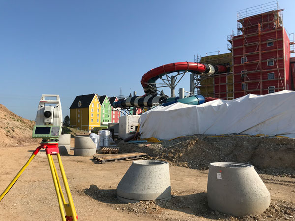
Bringing an Aqua Park to Life

One memorable success story was the use of our products for AEC survey tasks during construction of Germany’s biggest aqua park, Rulantica. The survey work was led by Saladin Keller of Keller planen + bauen. The project involved the creation and construction of a Nordic-themed water world featuring 25 attractions, including water slides, a wave pool and a lazy river.

Alongside all the typical surveying for AEC tasks — establishing site control, staking out pipes, and planning and staking the entire traffic infrastructure — Keller had the challenge of measuring and positioning the complex internal geometry. These tasks required skilled surveyors and a variety of survey tools, such as total stations, GNSS rovers, laser scanners and powerful processing software.

Operating within the AEC environment also meant that communication and flexibility were key to the success of the project. Keller needed to provide the right data to different trades and handle urgent maintenance requests requiring surveying skill, such as rebuilding parts and adjusting utilities.

Publicerad den Lämna en kommentar

AEC firms use aerial mapping to share in infrastructure funding

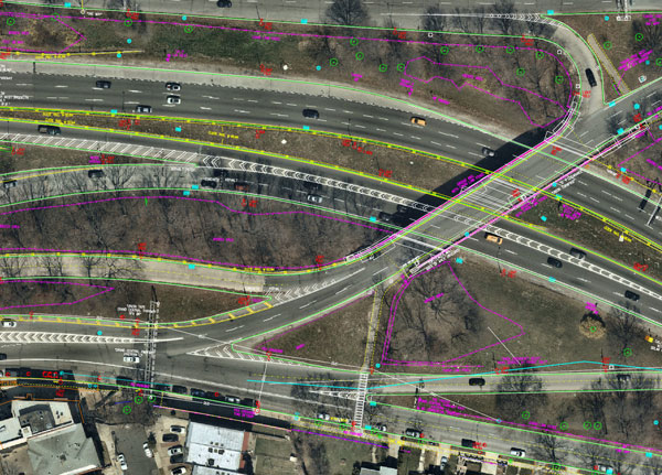
Nearmap aerial imagery is used as a basis for survey linework. Photo: Nearmap

Nearmap aerial imagery is used as a basis for survey linework. Photo: Nearmap

With Congressional approval of $17 billion in infrastructure funding, the largest single allocation ever, the scramble to win contracts is about to get red hot and AEC firms are gearing up. In this very competitive game, top engineering firms are relying on their experience, technology, business acumen and ability to execute.

Advances in aerial mapping play a key role in how AEC firms pursue these contracts. Savvy firms have been using this technology for years. Rather than rely on lower resolution satellite imagery or local drone imagery, they use wide-area-coverage aerial maps to clearly display the detail needed to plan and execute.

Over the past decade, maps made using aerial photogrammetry have played an important role in the AEC space. Using high-performance cameras, fleets of planes capture hundreds of square miles per plane per day, provided that the weather is clear. The imagery is processed and made available to engineering companies within days of capture, allowing them to see very clear imagery.

AEC organizations use different forms of aerial maps to evaluate sites, improve their survey designs, and build and maintain infrastructure (roads, highways, bridges, tunnels, overpasses, rail, airports, housing, commercial building development, water resources, parks, pavement and more). Imagine you’re a state or local government that needs to build a bridge, or a developer who wants to contract with an engineering and construction firm to build affordable housing. Why travel to perform time-consuming site evaluations when you can meet with engineering teams in your office and review hundreds of potential sites instantly using current aerial photos that show change over time?

The engineering teams point out elevation changes, the presence and height of vegetation, neighboring communities, bodies of water, ponding and more. They easily navigate from one location to another as you discuss where the entrance to the community could be, how the road network might be configured, and the proximity to retail, schools and healthcare. Within minutes you measure risk, understand the landscape, make decisions, and begin to estimate the project costs. Your teams collaborate, discuss the pros and cons, measure distances and navigate across the terrain virtually.

Aerial mapping provides a competitive advantage for AEC companies to win their fair share of the infrastructure bill. It also gives governments and developers the confidence they need to make the right decisions. Typically, this involves looking at sites from all angles. The classic form of aerial mapping used by engineers is a top-down perspective. Increasingly, these organizations have used oblique imagery captured at an angled perspective, which shows height.

Artificial Intelligence and Aerial Photography

Starting a few years ago, 3D imagery and digital surface models began to allow engineers to navigate through the imagery and query it based on elevation. More recently, aerial mapping has leveraged artificial intelligence (AI) to classify properties and the landscape. Do you need to see nearby construction sites? AI applied to aerial photography can do that automatically. This rich set of data includes attributes such as tree overhang, roof condition, roof material, building footprints, vegetation height, surface material, swimming pools and even solar panels.

The blend of all these imagery types and AI into a single solution makes everything discoverable. Users can search by address, city, location or point of interest. They can visualize the imagery along with lat/long coordinates and quickly switch from top-down views to obliques to 3D. As they learn more about the landscape, they begin to turn on AI attributes, gaining deeper insights.

Sometimes, the analyses go even further. Engineering organizations export the imagery to tools of their choice from such companies as Autodesk, Esri or Bentley Systems, use field-collected ground control points to ensure that it is survey grade, then use it as a base layer for their designs. They even create marketing presentations and video content to help them win the business. Current high-resolution aerial maps have become a cornerstone of how these organizations operate.

This approach provides unique advantages for engineering firms. For example, they can combine geospatial and construction datasets in a common operating environment to reduce complexity, streamline communication, ensure that all stakeholders are up to date, and check their progress toward meeting contractual obligations.

Planners have current, contextual designs and models to make accurate decisions about planning and development activities. They can view asset locations and conditions to facilitate maintenance and upgrades, leverage aerial maps inside other platforms to improve work orders and reduce field visits, and ensure regulatory compliance.

Whether it’s improving highway safety, constructing ferry terminals, improving transportation systems, developing land or building a network of recreational trails, aerial imagery provides engineering and construction companies with a competitive advantage to win new business, improve client satisfaction and meet growth targets. With $17 billion on the line, sophisticated firms are finding a way to secure their fair share of the pie.

Publicerad den Lämna en kommentar

Russia could target GPS, warns NRO director

NRO Director Christopher Scolese

NRO Director Christopher Scolese

Russia’s military could target GPS and communication satellites as part of its war in Ukraine, reports Space News.

The news outlet cites U.S. National Reconnaissance Office (NRO) Director Christopher Scolese speaking Feb. 23 at the National Security Space Association’s Defense and Intelligence Space Conference.

“I think we’re seeing pretty clearly that Russia is committed to doing what they want to do in Ukraine, and they want to win,” Scolese said. “So I think it’s fair to assume that, to the extent that they can, and to the extent that they feel it won’t extend the conflict out of their control, that they will extend it into space.” 

An attempt to disrupt the United States’ space ability could affect satellites of private operators as well, such as Maxar, which is distributing imagery of the conflict.

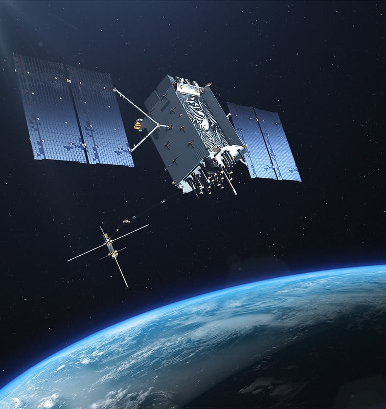
The U.S. Air Force’s Lockheed Martin-built next generation GPS III satellite on orbit. Rendering portrays GPS III Space Vehicles (SVs) 01-10. (Artist's Rendering: Lockheed Martin)

A next-generation GPS III satellite on orbit. (Artist’s Rendering: Lockheed Martin)

Publicerad den Lämna en kommentar

JAVAD GNSS: A Surveyor’s Perspective

Shawn billingS, RPLS, reinvests some of his profits in surveying gear, like this JAVAD GNSS unit. (Photo: Rebecca Billings)

Shawn Billings, RPLS, reinvests some of his profits in surveying gear, like this JAVAD GNSS unit. (Photo: Rebecca Billings)

By Shawn Billings  
RPLS, Proprietor, Pendulum Surveying and Dealer

The AEC industry relies on surveyors to be a bridge between the existing landscape and the design landscape. Surveyors have been providing virtual reality for centuries, albeit in a mostly analog way, until very recently.

Imagine that a school board needs a new school. It describes the need to an architectural or civil engineering company, which develops a conceptualized plan. Next, it is time to figure out how to adapt this rough concept to the real world. Will the school fit within the boundaries of its district’s property? How will it access public rights-of-way? Can the current roads accommodate the traffic it will bring? How will the school access utilities? How will the building impact existing stormwater drainage? How do various data collected by others (such as geotechnical and wetlands delineation) fit into the site plan?

The data collected by the surveyor inform the designer, usually in the form of a map — historically on paper, but now in digital form. Most designers want the key features extracted rather than a dense point cloud, so it is important for surveyors to be able to understand what those key features are.

AEC surveying differs from boundary surveying in several ways. First, it usually requires consideration of a 3D world, not only two dimensions. Secondly, it will usually involve many thousands of points, not a few tens of points as is usually the case in boundary surveying. Third, AEC surveying will typically involve many more stakeholders. Fourth, the liability in AEC surveying will usually (but not always) be greater because of the significant costs involved.

AEC surveying can be challenging because the timeframes are typically tight, with numerous professionals involved. Surveyors will often have to wait on others one day, only to be rushed the next day once the ball moves into their court. However, the tools available to us today allow us to collect data much more quickly than we ever could before.

Today, I can carry almost everything I need to survey in a compact car—my Javad GNSS real-time kinematic (RTK) system, my robotic total station, my handheld electronic distance measuring device, my laptop computer, my smartphone (which provides internet access), my digital camera, my lidar and my photogrammetric drone, as well as the accessories needed for each device. All these devices have become more portable, more powerful, and less expensive. The gains in efficiency have reduced fieldwork by more than half over the past couple of decades, requiring fewer people and generally providing much better quality data.

Today, it is rare for a surveyor to provide paper deliverables to designers. Almost all prefer digital files, usually vector data in DWG or DGN format along with surfaces in XML format.

Recently, I have worked on several small commercial building projects. The requirements were the same for each. The initial survey includes (among other things):

  • a title boundary survey
  • the location of existing utilities and structures
  • contours at one-foot intervals
  • the delineation of the floodplain, if present on the site
  • the location of streets and other public access.
  • Once the initial survey is complete, I often set control for machine control, which heavy machinery uses to perform grading without requiring stakes. Once grading is complete, I often stake out building locations and sometimes paving.

Challenges have included working with city planners who do not always have the same sense of urgency as the project developers and designers.

Perhaps the greatest lesson I have learned is the importance of being efficient without being in a hurry, which breeds mistakes, such as missing important details or breaching a safety protocol and causing a serious injury.

I also have learned that while technology can increase profits, it is important to reinvest some of them into improving my work product. This way, I enjoy a better return on my investment, but I also enjoy a better deliverable for my clients.