Photo: Terra Drone Indonesia
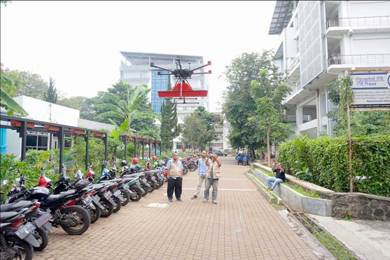
Terra Drone Indonesia, a group company of Japan-based Terra Drone Corp., has successfully completed a pilot project at the Bandung Institute of Technology (ITB) in Indonesia. The project included flying a drone equipped with a Ground Penetrating Radar (GPR) system over the campus to map tunnels and underground utilities.
The drone data was then processed and compared with the infrastructure records of the university by geophysicists, who determined the underground assets were accurately and precisely mapped, Terra Drone Indonesia said.
According to Terra Drone Indonesia, the combination of GPR and drones opens up new potential for the use of unmanned technologies in areas that are traditionally challenging and unsafe, such as post-blast areas in open-pit mines. A GPR drone also could be used to locate underground pipes, map the conditions of the assets and detect hazards like pipeline leaks.
“The conventional GPR method requires field personnel to go to the field and carry GPR tools to conduct surveys,” said Michael Wishnu Wardana, managing director at Terra Drone Indonesia. “But this method has its own dangers because not only are some areas unsafe and difficult to reach, but also because severe weather conditions in the field can hamper workers from carrying out their jobs diligently. GPR drones, in contrast, have emerged as a much safer and efficient surveying solution.”
Terra Drone Indonesia worked on this project in collaboration with PT Airborne Geophysics Indonesia and the Geophysics Laboratory at ITB. TerraDrone Indonesia has worked with ITB in the past as well, validating Terra Lidar’s topographic mapping capabilities at ITB’s Jatinangor Campus.