Publicerad den Lämna en kommentar

WarLoc locates foot soldiers in GPS-denied areas

Photo:

Photo: Robotics Research

A new system, called WarLoc, makes it possible to locate warfighters and first responders in GPS-denied environments.

Created by Robotic Research, a manufacturer of autonomy and robotic technology, the system provides localization and positioning data for teams entering underground facilities and traveling inside buildings and in urban canyons.

According to the company, multiple systems — including, besides WarLoc, robotic systems, UAVs and manned vehicles equipped with its technology — collaborate to enhance accuracy and maintain the localization of teams.

Its system, the company said, is unique in that “it has very small 3D position error in such a small package” and its filtering algorithms, rather than being centralized, are “distributed and opportunistic in nature to provide the best solution given the communications available.”

In January, Robotic Research received a $16.5-million order for WarLoc from the U.S. Army Product Manager Sets, Kits, Outfits and Tools (PM SKOT) to support forward-deployed U.S. military personnel. The company will deliver the WarLoc units to equip four deployed U.S. Army Brigade Combat Teams. The first batch has been shipped. The procuring organization, PM SKOT, provides Army and Joint Services oversight of the lifecycle for all sets, kits, outfits and tools used by U.S. soldiers.

Distributed System

A self-contained localization system typically relies on GNSS signals, when available, complemented by inertial navigation. By contrast, the WarLoc is a distributed system meant to work as a team, said Alberto Lacaze, Robotic Research’s co-founder and president. The problem, he explains, is how to filter these devices. Centralized approaches, in which every device sends its information to a central computer that does all the filtering, “work very well for an incident commander with a group of first responders going into a building, where the distances are relatively small.” However, he pointed out, they do not work when communications go down.

The alternative approach is to filter the information opportunistically, in a distributed fashion, which is what WarLoc does. In GPS-denied environments, “there is a process that synchronizes all the nodes once the communications have been established,” Lacaze said. “However, if you have, for example, two team members that are each in their own radio bubble, their solutions will continue to be optimized and other team members might be in their own bubbles, so their solution is also being optimized. If these two teams get in contact, their information will get synchronized and collectively optimized.”

The system, he adds, is “heavily reliant on the inertial solution and dead reckoning.” The more units can communicate and share data, the more accurate the navigation solution is. “In a relatively small package, we can achieve better than 1% error of distance traveled for a single unit,” said Lacaze. “Once you have multiple units communicating and measuring with each other, the solution gets significantly better.”

WarLoc, which contains all the required hardware and software, connects to a system used by first responders and the Department of Defense’s Android Tactical Assault Kit (ATAK) also being used in GPS-enabled areas. “Our system can be used not only for tracking humans, but also for tracking animals and other devices, such as robotic systems or vehicles,” Lacaze said.

Relative Localization

On the commercial side, the company has created a kit for autonomous shuttles and is deploying it in about 20 cities around the world. Like WarLoc, this device also works in GPS-denied areas, such as on an underground shuttle on a university campus. “We just won a contract to automate the busses that go through the Lincoln Tunnel,” Lacaze said.

Busses or shuttles using Robotic Research’s system “learn landmarks in the area that they are traversing and use them as an aid in localization, in conjunction with inertial units,” Lacaze said. “The vehicles learn their surroundings.” They don’t care about their absolute position, he explained, only about their relative position with respect to those areas. This is similar to pre-GPS directions like “Make a left at the post office, then a right at the gas station.” They can also use a common landmark. “If the first vehicle is seeing a certain building and knows its lat/long and the second vehicle saw that building some time ago, it can measure its distance from it using its own inertial system.”

While warfighters communicate their position information via their personal tactical radios to ATAK, which then shares it through its current radio infrastructure, vehicles on the road communicate it through dedicated short-range communications (DSRC) radio, a cell network, or some other network.

Other Robotic Research Programs

Robotic Research’s technology supports a range of robotics and autonomous vehicles in GPS-denied environments, including shuttles and buses for public transportation, hybrid unmanned aerial and ground vehicles (UAVs and UGVs), and trucks in the U.S. Army Autonomous Ground Resupply (AGR) Expedient Leader-Follower program.

The company is the prime contractor on several Army programs, including AGR, which consists of robotic trucks that the Army will begin to deploy. “We have delivered close to 100 of those trucks,” said Lacaze. “So, for example, if you are in a convoy and you need to know whether your warfighters are inside or outside a truck, WarLoc can tell you.”

Robotic Research’s AutoDrive autonomy kit, which can be retrofitted to vehicles of all sizes, provides autonomous functionality on surfaces ranging from urban-improved roads to off-road terrain, while the vehicle collects and analyzes data. The technology provides automation to one of the largest international shuttle providers as well as to the largest U.S. manufacturer of commercial buses, according to the company.

In February, the company announced it will begin testing totally unmanned, fully autonomous, low-speed shuttles in the second quarter of this year. It will initially involve attendants in fixed on-site locations, then will aim to move attendants to an offsite safety-monitoring facility.

Publicerad den Lämna en kommentar

GPS celebrates 25 years of operation

“Celebrating this anniversary gives us a moment to recognize how far we’ve come, but also to get pumped about what lies ahead for our program and our role in executing that.”


By  First Lieutenant Tyler Whiting
Peterson Air Force Base, Colorado

The Global Positioning System marks its 25th year of operation Apr. 27, 2020.

On this date in 1995, the system reached full operational capability, meaning the system met all performance requirements.  U.S. Air Force Space Command formally announced the milestone three months later.

“This is a major milestone,” Gen. Thomas S. Moorman Jr., former Air Force Vice Chief of Staff, said in 1995. “GPS has become integral to our warfighters and is rapidly becoming a true utility in the civilian community.”

Initially developed for the military to meet a critical need for determining precise location on the battlefield, GPS has also become an integral part of technology affecting the lives of billions of people worldwide.

“The United States Space Force’s continuing objective for the constellation is to ensure GPS remains the Gold Standard for global space-based positioning, navigation and timing,” said Gen. Jay Raymond, USSF Chief of Space Operations, and U.S. Space Command Commander.

Image: USAF

Image: USAF

Today, the U.S. Space Force operates the GPS satellite constellation as a global utility – always available to everyone, everywhere on Earth.

“GPS is a free for use service provided by the Space Force that enhances everyday lives around the world,” said Brig. Gen. DeAnna Burt, USSF Director of Operations and Communications. “GPS provides the highest accuracy positioning and timing data.  In addition to the essential capabilities it provides for the military, GPS underpins critical financial, transportation and agricultural infrastructure.  It’s always available, whether for an ATM transaction or securing a rideshare.”

Military capabilities

Its military capabilities first enhanced combat operations in 1990 and 1991 during Operations Desert Shield and Desert Storm. Allied troops relied heavily on the new GPS signal to navigate the featureless deserts in Kuwait and Iraq.

In the early 2000s, during Operations Enduring Freedom and Iraqi Freedom, GPS contribution to warfighting increased significantly.  For example, the GPS constellation enabled accurate munitions, allowing the delivery of GPS-aided Joint Direct Attack Munitions with pinpoint precision and minimal collateral damage.

Today, in addition to these and other GPS-enabled warfighting capabilities, Airmen conduct resupply missions with battlefield precision airdrops to combat forces with GPS-guided, parachute-delivered equipment pallets known as “Smart Pallets.”

Continually updated

The GPS operational constellation currently has 31 satellites, and the system is continually updated and modernized, making it a resilient system to maintain the signals required for accurate positioning, navigation and timing around the world.

The first satellite of the new GPS III version, called Vespucci, was launched into space Dec. 23, 2018.

The 2nd Space Operations Squadron at Schriever Air Force Base, Colo., operates GPS. The squadron recently accepted control of the second GPS III satellite, called Magellan, on March 27.

GPS III is meeting users’ emerging needs and responding to tomorrow’s threats with improved safety, signal integrity and accuracy. GPS III satellites are more accurate, have improved anti-jamming capabilities, and have doubled the design life; when compared to previous iterations of GPS. They are also designed to incorporate new technology and changing mission needs,

“The 25th Anniversary is a huge, momentous occasion for us. We take great pride in providing this global utility to the approximately six billion users worldwide,” said Lt. Col. Stephen Toth, 2nd SOPS commander. “Celebrating this anniversary gives us a moment to recognize how far we’ve come, but also to get pumped about what lies ahead for our program and our role in executing that.”

Publicerad den Lämna en kommentar

Septentrio demystifies GNSS corrections

This insight column from Septentrio explains the role of GNSS corrections in precise positioning. It explores the three most popular correction methods: RTK, PPP and PPP-RTK.

Let’s say you need reliable accurate global positioning in your technology. You do some research and decide to get yourself a multi-frequency GPS/GNSS receiver. You order an evaluation kit, but how to get your receiver to deliver the high accuracy that it promises?

GNSS receivers rely on external corrections to compensate for GNSS errors to achieve decimeter- or centimeter-level accuracy as fast as possible.

Correcting GNSS errors

GNSS-based positioning is calculated using a method that, by itself, is limited in accuracy due to several errors caused by GNSS satellites as well as the Earth’s atmosphere.

  • Even the advanced clocks on board GNSS satellites experience minute drifts that cause clock errors.
  • The movement of GNSS satellites is predicted as they orbit the Earth. These predictions are not perfect, which results in orbit errors.
  • Satellite equipment introduces small signal errors, which are modeled as satellite biases.
  • Atmospheric errors caused by distortions and delays are experienced by the signal as it passes through the Earth’s ionosphere (outer layer) and troposphere (layer near the Earth’s surface).
  • The local environment around the receiver as well as the receiver itself can introduce errors. For example, satellite signals can be reflected off buildings and tall structures (multipath).

A GNSS receiver cannot correct satellite and atmospheric errors by itself; it relies on data provided by an external source. Clock and orbit errors are satellite-dependent, and so are the same around the world. Atmospheric errors, on the other hand, depend on the path the signal takes as it travels from the satellites to the user, differing depending on the receiver’s location.

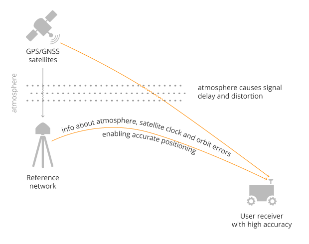
To overcome both satellite and atmospheric errors, a reference station (also known as a base station) can be used. A reference station — a GNSS receiver installed at a fixed and precisely known location — estimates GNSS errors and sends them in the form of GNSS corrections to the user receiver. A reference network consists of interconnected reference receivers spread over a geographic area.

A user receiver gets data sent from a GNSS reference station to correct satellite and atmospheric errors. (Image: Septentrio)

A user receiver gets data sent from a GNSS reference station to correct satellite and atmospheric errors. (Image: Septentrio)

Receiver-side errors can only be handled partially, by robust receiver technology and careful operation. Depending on which type of corrections are applied, it can take a few seconds to several minutes of initialization time for high accuracy to be achieved.

Types of corrections for high-accuracy positioning

Until recent years, RTK and PPP have been the established methods of providing GNSS corrections to user receivers. But the demand for high-accuracy positioning is on the rise, paving the way for new positioning techniques such as the hybrid PPP-RTK.

RTK: Highest level of accuracy. With the RTK (real-time kinematic) method, a user receiver gets correction data from a single base station or a local reference network. It then uses this data to eliminate most of the GNSS errors.

RTK is based on the principle that the base station and the user receiver are located close together (a maximum 40 kilometers or 25 miles apart) and therefore “see” the same errors. For example, since the ionospheric delays are similar for both the user and the reference station, they can be cancelled out of the solution, allowing higher accuracy.

While in the RTK method corrections are provided for a specific location, in the PPP and PPP-RTK methods, a correction model is broadcast to a larger area, but with slightly lower accuracy. To transmit this correction model, a message format called SSR (Space State Representation) can be used. There is some confusion in the industry about the term “SSR” since it is often associated with the newer PPP-RTK method. But be careful, since “SSR” is occasionally used as a buzzword to refer to traditional PPP services as well.

PPP: Globally accessible and accurate, but at a cost. Precise point positioning (PPP) corrections contain only the satellite clock and orbit errors. Since these errors are satellite specific, and thus independent of the user’s location, only a limited number of reference stations is needed around the world. Because atmospheric errors are not included in PPP corrections, only a lower accuracy level can be achieved with this method. Also, a longer initialization time is expected of up to 20-30 minutes, which may not be practical for some applications. PPP has been traditionally used in the maritime industry; today it has expanded to various land applications such as agriculture as a convenient way to get global GNSS corrections.

PPP-RTK: Best of both worlds? PPP-RTK (a.k.a. SSR) is the latest generation of GNSS correction services, combining near-RTK accuracy and quick initialization times with the broadcast nature of PPP. A reference network, with stations about every 150 kilometers (100 miles), collects GNSS data and calculates both satellite and atmospheric correction models.

As explained above, atmospheric corrections are regional, and so a denser reference network is needed than for PPP. These corrections are then broadcast to subscribers in the area via internet, satellite or telecom services. Subscribed receivers use the broadcast correction model to deduce their location-specific corrections, resulting in sub-decimeter accuracy.

Comparing the three GNSS correction methods

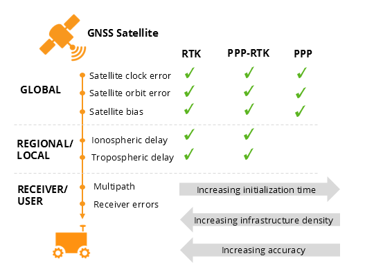
The table below compares the three correction methods, highlighting their strengths and weaknesses.

Table: Septentrio

Table: Septentrio

The infrastructure density and initialization time for all three methods vary with the different kinds of errors that are corrected. The broadcast nature of PPP-RTK and PPP, as well as the lighter infrastructure that they require, makes these methods scalable for mass-market applications.

Types of errors which are corrected by each of the three methods. (Image: Septentrio)

Types of errors that are corrected by each of the three methods. (Image: Septentrio)

Some GNSS receivers also incorporate advanced positioning algorithms to compensate for receiver-side issues such as multipath (for example, see Septentrio APME+), jamming and spoofing. This adds reliability and robustness to high-accuracy positioning.

Getting GNSS corrections

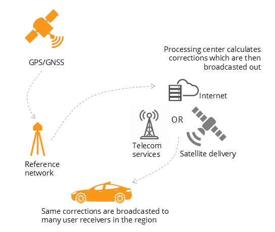
Modern industrial receivers often get their GNSS corrections via a subscription service, delivered via internet (using NTRIP protocol), satellite or 4G/5G. Today, there is a boom in the correction-service market driven by high-accuracy demands of the automotive industry, automation and smart consumer devices. Automotive suppliers and many other new players are deploying infrastructure to set up services for centimeter-level positioning around the globe.

User receivers often get their GNSS corrections via a subscription service delivered via Internet, satellite or 4G/5G. (Image: Septentrio)

User receivers often get their GNSS corrections via a subscription service delivered via internet, satellite or 4G/5G. (Image: Septentrio)

PPP and PPP-RTK corrections can even be transmitted directly by the GNSS satellites, as in the Japanese CLAS service from the QZSS constellation, or in the planned High-Accuracy Service (HAS) from Galileo. Depending on the network density and quality of the error modeling, different initialization times and accuracies can be achieved. This means that positioning quality can vary from one service provider to another.

Major telecom companies such as Deutsche Telekom as well as the Japanese Softbank and NTT are equipping their infrastructure with GNSS receivers to enable new corrections services. 3GPP, which provides specifications for mobile telephony including LTE, 4G and 5G, now covers broadcasting of GNSS satellite corrections in its mobile protocol. Since reference receivers are becoming part of critical infrastructure, such as telecom towers, it is essential that they have a high level of security to protect them from potential jamming or spoofing attacks (for example, Septentrio AIM+ technology).

Which corrections are right for me?

The right correction service for your technology will depend on your location and service area, your accuracy and reliability needs, as well as your budget. Because the corrections market keeps expanding, it is now more important than ever that integrators or GNSS manufacturers assist you in selecting the best correction method for your industrial application.

If you choose a GNSS receiver which does not “lock” you to a certain correction service, you will be free to choose a correction method which is most suitable for your application and its location. Such “non-locking” open-interface receivers also offer customers flexibility to switch to another more beneficial service in the future, as correction methods keep evolving.

Publicerad den Lämna en kommentar

WGIC: Geospatial analytics at forefront of COVID-19 fight

WGIC logoOne industry important to the world’s fight and recovery from the COVID-19 pandemic is geospatial analytics. In response, the World Geospatial Industry Council (WGIC) has created an information hub for COVID-19 information.

“These are very uniquely challenging times for our industry. At the same time, our industry has stood up to assist the world, especially the key decision-makers and frontline workers to understand the scenarios on the ground,” said Harsha Vardhan, WGIC associate director. “Spatial analytics-based decision making has come to the forefront during these times.”

Governments are using location tracking in combination with personal data to track and combat COVID-19, and the use of location technology in conjunction with personal data is of high relevance and usage, Vardhan said. “This scenario brings before us the aspects of data privacy, data protection, and the role of geospatial information.”

In March, WGIC published a report titled “Geospatial Information and Privacy: Policy Perspectives and Imperatives for the Geospatial Industry.” Vardhan said the report is even more significant now. WGIC is hosting a webinar on the report on May 14 at 11 a.m. ET.

Publicerad den Lämna en kommentar

Vesedia proposes COVID-19 contact tracing platform

Vesedia Mobile Technologies is offering to deploy its location platform to help control the COVID-19 pandemic through tracking and dissemination of information about “at risk” infection areas and places, and times when they were known to have infection — a process referred to as contact tracing.

Vesedia is a technology startup with a suite of mobile apps for children and family safety based on a location-sharing platform and location-tracking artificial intelligence (AI).

“The platform would warn people that passed through these places at matching times,” explained Ruslan Shalaev, co-founder and team leader, Vesedia. Shalaev developed a popular app for family safety: Safely – Family Location; and serves as a lead research on user-location monitoring AI in an academic partnership with Binghamton University and Lviv National University.

The platform would be applicable after the initial pandemic is contained. “It would help with restarting the economy and resuming normal business operations by providing a mechanism to track, control and suppress new outbreaks,” Shalaev said.

Data Sources

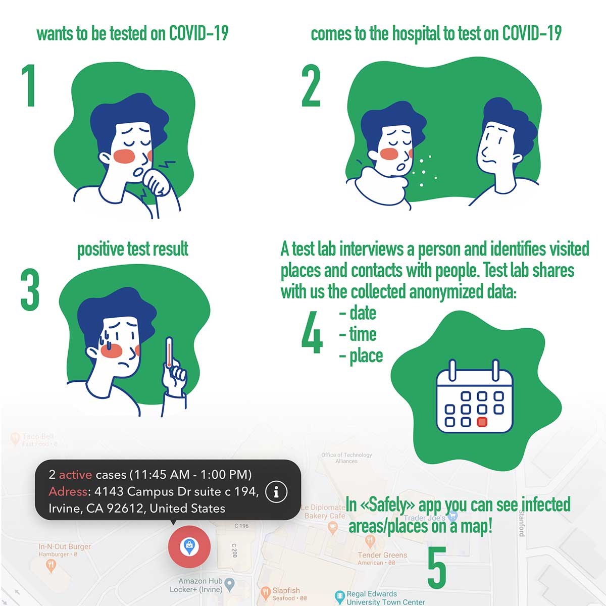
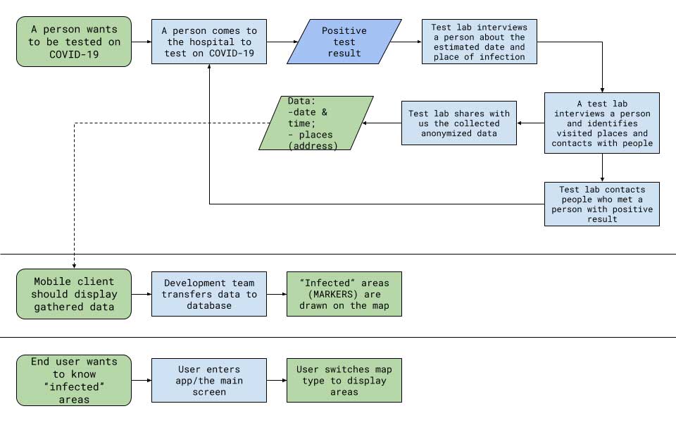
Under the plan, people that test positive to COVID-19 would be asked to provide information about public places they visited in the preceding days, and at what times. Individuals that provide the information can confirm that it’s accurate from their phone location history.

The information would be anonymized by healthcare officials, and entered into a database that would be publicly accessible via a website and mobile app.

Image: Vesedia

Image: Vesedia

Mobile App

The mobile app aspect is especially valuable from information dissemination standpoint, because other people in “at risk” areas can receive automated alerts to self-quarantine and get tested based on their device location history.

The app is ready and available for download in Google Play and Apple App Store.

Workflow diagram

Workflow diagram. (Image: Vesedia)

Workflow diagram. (Image: Vesedia)

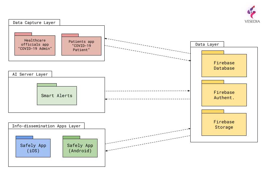
System architecture

System architecture. (Image: Vesedia)

System architecture. (Image: Vesedia)

Approach validity

The approach has been successfully applied in Singapore, but without active alerts, with dissemination of information being done manually. The Singapore government was able to contain the virus without shutting down businesses, schools, public transit and restaurants.

Vesedia location apps

Vesedia is a tech startup founded in 2016 by SUNY Binghamton Computer Science graduates. It developed SmartAI location tracking and sharing platform. Its apps include Safely – Family Location, Virtual Nanny, MeetCity – Live Events, Blind Date, Sponter – Social Network in partnership with Lviv National University and Binghamton University.  The apps are available for download in the Google Play and Apple App stores.

Vesedia research on “Location-Based Behavioral Patterns Modeling” was published at Institute of Electrical and Electronics Engineers – Intelligent Data Acquisition and Advanced Computing Systems (IEEE/IDAACS) conference in Metz, France in 2019.

Publicerad den Lämna en kommentar

Blue Bear successfully demonstrates BVLOS drone swarm

Launch of the RedKite drone. (Photo: Blue Bear Systems)

Launch of the RedKite drone. RedKite is a long-endurance sub-20-kg UAS designed to carry payloads of up to 5 kg. (Photo: Blue Bear Systems)

Blue Bear Systems Research Ltd. has successfully demonstrated a fully autonomous suite of multiple drone swarm assets under beyond-visual-line-of-sight (BVLOS) conditions.

The technology enables complex drone operations where multiple assets are able to carry out simultaneous tasks controlled by a single user to create a swarm effect.

The five fixed-wing drones clocked up to 15 hours of flying time, over four days, in challenging weather conditions. The swarm comprised a combination of Blue Bear’s Redkite and Cobra fixed-wing systems, which flew multiple simultaneous sorties from a test range in the northwest of England.

The drones were equipped with the latest automatic dependent surveillance-broadcast (ADS-B) technology, and the airspace was managed by Blue Bear’s airspace deconfliction software. All of the assets were controlled by a single operator from Blue Bear’s mission command control system in Bedfordshire, England.

“This is an exciting development for us, proving our ability to operate multiple drones, simultaneously, using the latest Blue Bear technology to deliver a swarm effect under BVLOS conditions,” said Ian Williams-Wynn, managing director of Blue Bear Systems.

Publicerad den Lämna en kommentar

Optical Zonu announces GPS tester for antenna installation

Optical Zonu has introduced the ZonuSkyShot GPS tester, designed for quick testing during the critical installation phase of an antenna at a new site build or small cell integration.

The compact tester is designed for integrating one of Optical Zonu’s GPS solutions, but is equally capable of working as a neutral testing device.

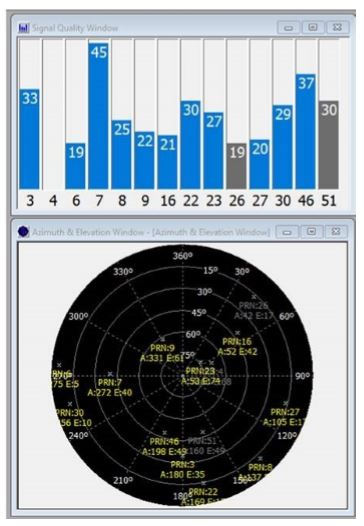
Fig. 1. Screenshot of ZonuSkyshot software output. (Screenshot: Optical Zonu)

Fig. 1. Screenshot of ZonuSkyshot software output. (Screenshot: Optical Zonu)

The ZonuSkyShot is a compact GPS receiver that detects the presence of a GPS signal, indicated on the top-panel LED. The receiver can be accessed at the USB port on the base unit, allowing the user to see the available satellites by using the app provided with the system and available at the Optical Zonu website.

The receiver can simultaneously track up to 16 satellites while searching for new ones. Because of this, a problem can be found and mitigated when a GPS antenna is installed, rather than when hardware is being integrating further down the line. Close-out of projects can be indicated with with screenshots of satellite visibility via the micro-USB port to a laptop.

The app provides:

  • RF GPS signal presence
  • GPS antenna functionality
  • Optical transmitter functionality
  • Fiber connectivity
  • Optical receiver functionality

Pre-orders are now being accepted for the kit, which includes the handheld device with power supply, carrying case, jumpers and SMA cable.

Publicerad den Lämna en kommentar

QGIS Grants #5: Call for Grant Proposals 2020

Dear QGIS Community,

Our previous rounds of grant proposals have always been a great success (2019, 2018, 2017, 2016). We are very pleased to announce that this year’s round of grants is now available. The call is open to anybody who wants to make a funded contribution to QGIS, subject to the call conditions outlined in the application form.

The deadline for this round is 24th May 2020.

For more details, please read the introduction provided in the application form.

We look forward to seeing all your great ideas for improving QGIS!

Nyhet från QGIS, orginal inlägg

Publicerad den Lämna en kommentar

NCDOT initiative use drones for COVID-19 relief efforts

Photo: Shutter2U/iStock / Getty Images Plus/Getty Images

Photo: Shutter2U/iStock / Getty Images Plus/Getty Images

The North Carolina Department of Transportation (NCDOT) is working with public and private partners to launch three projects using drones to aid in COVID-19 relief efforts. According to NCDOT, the initiative will be launched in May.

For the first project, Novant Health and Zipline are proposing to deliver personal protective equipment and other medical equipment across Novant Health’s medical campuses in the Charlotte area.

For the second project, UPS Flight Forward and Matternet are proposing to work with a Winston-Salem hospital on an operation to use drones to take healthcare equipment, medicine and personal protective equipment to medical providers. UPS Flight Forward, which earned the necessary federal certifications to operate a drone airline, has an ongoing drone delivery service at WakeMed’s main campus in Raleigh, NCDOT said.

Finally, for the third project, Flytrex is proposing to deliver food from multiple restaurants in a shopping center to neighborhoods in the Holly Springs area.

The first two programs are aimed at reducing the strain on medical supply chains, and the third will make it easier for people to follow the stay-at-home order. According to NCDOT, officials will use data collected during the project to determine how this technology can be used in other areas of the country.

“North Carolina has been a leader in demonstrating how drones can help people in times of crisis,” said State Transportation Secretary Eric Boyette. “We look forward to putting this technology into productive use as we work to help citizens and medical professionals during the COVID-19 pandemic.”

Funding for the individual drone missions is coming from private partners, while NCODT is coordinating the initiative.


Read more of GPS World‘s coronavirus coverage here.

Publicerad den Lämna en kommentar

Inertial Labs releases 2-axis, 3-axis gyroscopes

Inertial Labs' TAG-200 two-axis and TAG-300 three-axis gyroscopes are designed for use in harsh environments. (Photo: Inertial Labs)

Inertial Labs’ TAG-200 two-axis and TAG-300 three-axis gyroscopes are designed for use in harsh environments. (Photo: Inertial Labs)

Inertial Labs has released its TAG-200 two-axis and TAG-300 three-axis gyroscopes, developed for electro-optical systems, gimbals, line-of-sight, and pan and tilt platforms for stabilization and pointing applications.

According to the company, TAG-200 and TAG-300 utilize advanced performance, tactical-grade MEMS sensitive elements, of which size, power consumption, reliability and performance are ideal for accomplishing complex tasks requiring accurate stabilization of assorted platforms.

The gyroscopes, designed for use in harsh environments, can withstand extreme shock and vibration in accordance with MIL-STD-810 ground mobile use, Inertial Labs added. In addition, they are fully digitized, include built-in test functionalities and have no moving parts.

Key advantages of the dual TAG-200 and triple TAG-300 axis gyroscopes include low noise, low latency, wide bandwidth, high data rate, low bias drift, low VRE, high MTBF and ITAR-free, Inertial Labs said. The gyroscopes are factory calibrated over operational temperature range with low non-orthogonality and misalignment between sensitive elements. They’re also QA/QC tested and supplied with individual calibration and acceptance test certificates.

Inertial Labs, based in Paeonian Springs, Virginia, manufactures orientation and navigation sensor solutions.