Publicerad den Lämna en kommentar

Trimble DA2 GNSS receiver launched for Catalyst positioning

The Trimble DA2 receiver boosts the performance of the Trimble Catalyst GNSS positioning service. (Photo: Trimble)

The Trimble DA2 receiver boosts the performance of the Trimble Catalyst GNSS positioning service. (Photo: Trimble)

Trimble has launched the Trimble DA2 GNSS receiver for the Trimble Catalyst positioning service. The DA2 — the second-generation receiver and antenna for the Catalyst service — now includes the Trimble ProPoint GNSS engine for enhanced performance.

Unique to the latest Trimble GNSS solutions, ProPoint technology reduces convergence times and improves positioning accuracy when operating near trees and buildings.

Trimble Catalyst is a subscription-based GNSS positioning service for location-enabled field applications. The service is available in accuracy-based packages from centimeter- to submeter-level for a wide range of mapping and mobile geographic information system (GIS) data-collection projects. Catalyst continues to support a broad range of GIS field applications, including Trimble TerraFlex software, for form-based GIS data collection.

“Trimble Catalyst brings easy-to-use precise positioning to location-enabled workforces,” said Gareth Gibson, marketing director, Trimble Mapping & GIS. “The addition of ProPoint technology, together with the DA2’s support for iOS devices, means Catalyst can now deliver Trimble quality positioning to more geospatial professionals than ever before.”

Trimble Catalyst subscriptions are available through Trimble’s Authorized Distribution Network. The Catalyst DA2 digital GNSS receiver, sold separately, is expected to be available in the fourth quarter. Trimble TerraFlex software subscriptions are available separately through Trimble Geospatial distribution partners.

Publicerad den Lämna en kommentar

Orolia joins with Keysight on advanced 5G GNSS testing

Integrated solutions address GNSS test requirements defined by 3GPP and major U.S. carriers

Orolia and Keysight Technologies Inc. have joined forces to advance 5G services by addressing GNSS test requirements defined by 3GPP and major U.S. carriers.

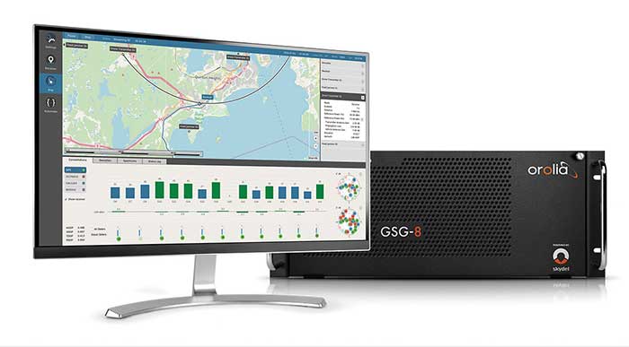
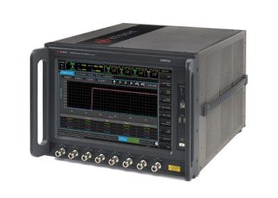
Working with Orolia allows Keysight to extend its 5G device test solution portfolio with advanced GNSS simulation capabilities. As a result, existing users of Keysight’s 5G device test solutions can easily address GNSS-related 3GPP protocol conformance and carrier acceptance test requirements by upgrading the software in Keysight’s E7515B UXM 5G Wireless Test Platform and combining it with Orolia’s GSG-8 simulator.

Skydel GSG-8 (Photo: Orolia)

Skydel GSG-8 (Photo: Orolia)

The efforts of Keysight and Orolia will enable chipset and device makers to verify functionality to accurately position mobile phone users within a geographic area.

“Working with Orolia has enabled Keysight to deliver GNSS-based LBS test solutions for 5G protocol conformance and carrier acceptance validation,” said Muthu Kumaran, general manager of Keysight’s device validation solutions business. “Keysight’s LBS solutions also support assisted GNSS test functionality, enabling users to comprehensively address 5G new radio conformance requirements mandated by both the Global Certification Forum (GCF) and PTCRB.”

Accurate positioning is important in a wide range of sectors including healthcare, road and aerial transportation, entertainment and homeland security.

Future applications, such as drones and autonomous vehicles, will depend on highly precise positioning services for reliable navigation and safe transportation of people and goods. Mobile operators use GNSS technologies and non-GNSS technologies, such as beamforming, angle-based positioning and round-trip time to deliver personalized services and support emergency calls.

Keysight's UXM 5G Wireless Test Platform. (Photo: Keysight Technologies)

Keysight’s UXM 5G Wireless Test Platform. (Photo: Keysight Technologies)

The GSG-8 simulator, powered by the Skydel Simulation Engine, offers high performance, flexibility and an easy-to-use software-defined platform to deliver superior jamming and spoofing options that can help ensure accurate, continuous operations for critical applications during interference or signal loss. Automated and scalable, the simulator supports GPS, Galileo GLONASS and BeiDou, with upgrade paths for future constellations.

Keysight offers in-built positioning capabilities in the UXM 5G wireless test platform for non-GNSS positioning test requirements.

“We are pleased to collaborate with Keysight on developing solutions that improve PNT testing for 5G communication networks and devices,” said Lisa Perdue, Orolia’s Simulation Product Line director. “Our GSG-8 simulator, powered by Orolia’s Skydel Simulation Engine, offers ultra-high performance and unmatched flexibility. The easy-to-use software-defined platform also delivers superior jamming and spoofing options that can help ensure accurate, continuous operations for critical applications during interference or signal loss.”

Publicerad den Lämna en kommentar

Boeing to build factory in Illinois to produce MQ-25 Stingray

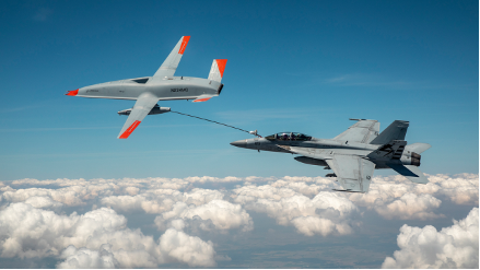
Boeing will build the U.S. Navy's MQ-25 Stingray unmanned aerial refueler at a new 300,000-square-foot facility at MidAmerica St. Louis Airport in Illinois. (Photo: Boeing)

Boeing will build the U.S. Navy’s MQ-25 Stingray unmanned aerial refueler at a new 300,000-square-foot facility at MidAmerica St. Louis Airport in Illinois. (Photo: Boeing)

Boeing will build the MQ-25 Stingray — the Navy’s first carrier-based unmanned aircraft — at a new high-tech facility in Illinois. The 300,000 square-foot facility at MidAmerica St. Louis Airport, Illinois, is scheduled for completion in 2024.

The MQ-25 facility will include state-of-the-art manufacturing processes and tools, including robotic automation and advanced assembly techniques, to improve product quality and employee ergonomics. The facility initially will employ 150 mechanics, engineers and support staff, but could grow to 300 with additional orders.

Boeing digitally engineered the entire MQ-25 aircraft and its systems, resulting in high-fidelity models used to drive quality, efficiency and flexibility throughout the production and sustainment process.

For two years, Boeing and the Navy have been flight testing the Boeing-owned MQ-25 test asset from MidAmerica Airport. In recent missions, the T1 model has refueled an F/A-18 Super Hornet, an E-2D Hawkeye and an F-35C Lightning II.

The U.S. Navy intends to procure more than 70 MQ-25 aircraft to help extend the range of the carrier air wing, and the majority of those will be built in the new facility. Boeing is producing the first seven MQ-25 aircraft, plus two ground test articles, at its St. Louis facilities, and they will be transported to MidAmerica for flight test. The MQ-25 program office, including its core engineering team, will remain based in St. Louis. MidAmerica is adjacent to Scott Air Force Base.

The new MQ-25 facility will be in addition to existing manufacturing operations at Boeing St. Clair, which produce components for the CH-47 Chinook, F/A-18 Super Hornet, F-15 and other defense products.

T1 Stingray refuels a Navy F/A-18. (Photo: U.S. Navy/Boeing)

T1 Stingray refuels a Navy F/A-18. (Photo:
U.S. Navy/Boeing)

Publicerad den Lämna en kommentar

Hemisphere GNSS announces Outback Guidance MaveriX for precision ag

Photo: Hemisphere GNSS

Photo: Hemisphere GNSS

Hemisphere GNSS has announced the Outback Guidance MaveriX for precision agriculture.  The solution is built around the new MaveriX agriculture application software platform to provide state-of-the-art guidance, steering and application control.

The MaveriX application software includes a new user interface that provides an innovative tablet-like user experience with improved 3D graphics. The included adjustable widgets give users the freedom to customize their UI experience.

“The announcement and the upcoming release of our new MaveriX solution is a key milestone for the Outback Guidance business and our loyal customer base,” said Jeff Farrar, general manager of Outback Guidance. “We are looking forward to building the Next Generation of Outback success for our customers on this new platform.”

New M7 and M10 terminals (7 inch and 10 inch) are the centerpiece of the MaveriX. The M-series terminals deliver the latest display technology. They provide enhanced situational awareness for users and preferred features like auto-scaling and pinch-to-zoom capabilities.

The MaveriX solution provides superior centimeter-level performance via the new eDriveM1 steering controller. The eDriveM1 offers AB Straight, AB Contour, Freeform Contour and Circle Pivot guidance modes and supports Shuttle Shift, Reverse Steer and the Outback Guidance eTurns feature for automated headland turns.

The eDriveM1 can be paired with the proven ESi2 Electric Wheel, existing OEM Steer Ready, or hydraulic retrofit interfaces.

Outback Guidance continues to offer machine specific installation kits for more than 1500 machine models. The A631 GNSS Smart Antenna delivers GNSS performance at scalable accuracy levels using real-time kinematic (RTK), SBAS and Hemisphere’s Atlas L-band service.

The A631 supports RTK base functionality when paired with the Outback RTK radio option. The powerful MaveriX technology platform supports the AC110 Rate and Section control to maximize implement functions during planting, spraying and application tasks.

Publicerad den Lämna en kommentar

Spiren’s new GNSS Foresight checks reliability for BVLOS

Spirent GNSS Foresight predicts where and when unmanned vehicles, air taxis and drones can operate safely and dependably beyond visual line of sight

Spirent Communications plc has launched Spirent GNSS Foresight, a cloud-based solution that lets operators know in advance where and when GPS or GNSS positioning is reliable for unmanned and autonomous journeys.

GNSS Foresight accurately predicts where and when unmanned vehicles, air taxis and drones can operate safely and dependably beyond visual line of sight (BVLOS), especially in urban areas where buildings frequently obstruct GNSS signals.

The service addresses a key issue facing developers and operators of unmanned aerial systems (UAS) and autonomous vehicles. Because GNSS performance can be unpredictable in urban and suburban areas from signals being obscured or blocked by buildings, autonomous systems have not been able to rely on GNSS for accurate positioning.


GNSS Foresight will be shown publicly for the first time at ION GNSS+ 2021 in St. Louis, Missouri (Sept. 22–24).


GNSS Foresight can produce forecasts using data from any of the world’s satellite constellations, and is of particular interest to the aviation and UAS sector, as well as the automotive industry.

“Accurate, reliable GNSS performance is a key enabler of game-changing innovations that are shaping our future — autonomous drones, air taxis, cars and trucks,” said Spirent’s vice president of PNT Assurance, Jeremy Bennington. “GNSS Foresight overcomes navigation and positioning challenges by providing real-world situational awareness ahead of time for pre-flight, or for real-time performance improvement, through a cloud-based service. It can be used to determine areas that are always safe to fly or operate in, in addition to finding the exact time in a degraded area when specific operational requirements can be met. GNSS Foresight enables operators to enhance efficiency, safety and ROI through the resulting operational improvements.”

Spirent GNSS Foresight’s ability to accurately predict where and when autonomous systems will perform enables users to scale operations or services by expanding operational areas, reducing the number of system disengagements, and providing a greater level of safety and reliability assurance when reducing — or ultimately removing — human involvement in the driving or piloting task.

GNSS Foresight can produce forecasts using data from any of the world’s satellite constellations, and is of particular interest to the aviation and UAS sector, as well as the automotive industry. It will be shown publicly for the first time at ION GNSS+ in St Louis (Sept. 22–24).

Image: acavalli/iStock/Getty Images Plus/Getty Images

Image: acavalli/iStock/Getty Images Plus/Getty Images

Publicerad den Lämna en kommentar

QGIS Open Day – 24 Sept 2021

Dear QGIS Users

On Friday, 24 September 2021 we will be holding our monthly QGIS Open Day!

Programme

My QGIS. Each of us has a specialty in QGIS and our own workflows and tricks join this months QGIS Openday to learn from each other.

Where to watch

Please see the event wiki page at for all the details of times and links for participation.

All of the YouTube live-streamed events will be recorded and made available on the QGIS Open Day Youtube channel.

If you missed the last event, have a look at the excellent contributions by Leonardo Nazareth (Brazil), Victoria Neema (Kenya), and Tim Sutton (Portugal):

(YouTube live streams sometimes take 24 hours to be available for catch-up viewing. Be sure to check back here for updates!)

Participants are kindly reminded to please read and observe our QGIS Code of Conduct and Diversity Statement to make these events a great experience for everyone!

Please contact Amy on Twitter @amzenviro or via the Telegram Channel if you have any queries or need help setting up events.

We look forward to seeing you there!

Regards

The QGIS Open Day Organising Team!

Nyhet från QGIS, orginal inlägg

Publicerad den Lämna en kommentar

Qualcomm Location Suite increases support for emergency services

Photo: FilippoBacci/E+/Italy

Photo: FilippoBacci/E+/Italy

To comply with Federal Communications Commission (FCC) E-911 regulations, Qualcomm Technologies has enhanced its Qualcomm Location Suite to provide improved horizontal and vertical positioning information. The upgrade will help first responders better determine the floor within a multi-story building from which an emergency call was placed.

The Qualcomm Location Suite is deeply integrated with Qualcomm’s Snapdragon Mobile Platforms and Snapdragon Modem-RF Systems that power millions of mobile devices in the U.S. The suite has supported emergency location services in the U.S. and globally for two decades.

The change will help mobile service providers comply with new E-911 regulations requiring that the horizontal and vertical position of each wireless caller be determined with a certain level of precision.

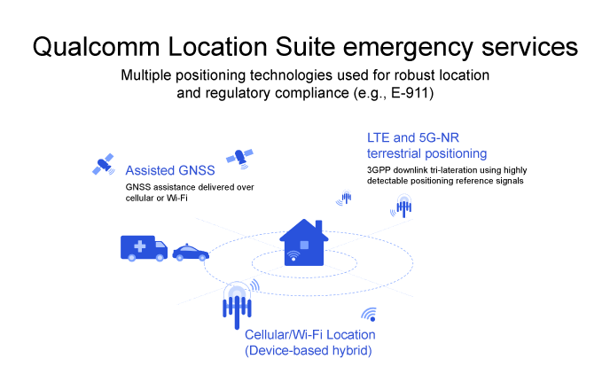
The Qualcomm Location Suite uses GNSS with network-based positioning and dead reckoning to deliver accurate location with speed and efficiency. GNSS assistance is delivered over cellular or Wi-Fi, LTE and 5G-NR terrestrial positioning; cellular/Wi-Fi-based location is also provided.

When an emergency call comes in, operators rely on a combination of triangulation of wireless signals and device positioning technologies, such as GPS, to provide the position of the caller. The use of technologies in the Qualcomm Location Suite is designed to result in highly accurate positioning information and the ability to share this reliable information with first responders, allowing them to reach the precise emergency site more quickly.

Qualcomm

Qualcomm

Publicerad den Lämna en kommentar

CHC Navigation introduces the NX510 Pro Auto Steer

High accuracy and economical steering solution for most tractors in any field type

Photo: CHCNAV

Photo: CHCNAV

CHC Navigation (CHCNAV) has released the NX510 Pro, a high-accuracy automated steering system designed for tillage, seeding, fertilization, pesticide application, and harvesting. With a steering controller and full GNSS RTK capability, the NX510 Pro can be quickly and easily mounted to various types of tractors and other farming vehicles to achieve ±2.5 cm pass-to-pass accuracy.

“The NX510 PRO is the new generation’s auto-steering system, engineered to dramatically reduce installation time, simplify daily operations and increase the productivity of farms of all sizes,” said Yorke Tang, product manager of CHCNAV’s Precision Agriculture division. He said the NX510 Pro allows farmers to afford a high-performance yet affordable auto-steer kit to retrofit their tractors to optimize their work, reduce input costs and fuel consumption, and meet the main goals of sustainable agriculture:

  • Increase farm income
  • Promote environmental stewardship
  • Enhance the quality of life for farm families and communities
  • Increase production for human food needs
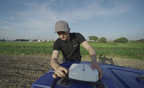
Installation of the NX510 Pro auto-steering system to a tractor. (Photo: CHCNAV)

Installation of the NX510 Pro auto-steering system to a tractor. (Photo: CHCNAV)

Quick installation. NX510 PRO takes less than one hour from installation start to operator use. The entire system can be installed in 30 minutes and calibrated in about 15 minutes, significantly reducing downtime costs in the field.

The intuitive AgNav software controls operations. It supports multiple guidance patterns to fit field layouts, including Straight AB line, A+ line, circle line, irregular curve and headland turn. It eliminates steering errors and overlapping passes on the field. The AgNav software also features real-time remote technical support from the local dealer’s help desk.

Powered by local, network or satellite-based RTK corrections, the GNSS+INS terrain compensation technology ensures ±2.5 cm hands-free accuracy on any terrain. The advanced controller ensures full RTK accuracy in seconds, provides smooth auto-steering and ensures repeatable long-term accuracy.

The CHCNAV NX510 Pro is now available worldwide.

Publicerad den Lämna en kommentar

Hi-Target launches GNSS/IMU RTK receiver for the field

Photo: Hi-Target

Photo: Hi-Target

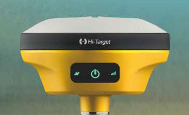
Hi-Target has introduce a new GNSS receiver, the V200. The V200 is a GNSS RTK receiver with an integrated nine-axis inertial measurement unit (IMU). The receiver is designed to provide superior performance and high-efficiency to support fieldwork with reliable solutions.

The advanced RTK engine and new-generation nine-axis IMU guarantees a 25% performance improvement over the company’s previous V100 model, even in demanding environments. It is designed to be easy to use and carry.

A smart Hi-Fix function supports the receiver to increase stability. Hi-Fix enables continuous connectivity and quality results even if the signal is lost while using an RTK base station or VRS network under extreme circumstances.

Advanced RTK Technology features

  • Full constellation support (receives GPS, GLONASS, Galileo, BDS, QZSS, SBAS, IRNSS)
  • 800+ channels
  • 9-axis IMU for better tilt survey performance
  • Increases productivity by 25%

Convenient Features

  • Lightweight at  820 grams
  • Can work continuously for more than 12 hours
  • Supported by the latest Hi-Survey Road software and smart Hi-Fix function

The V200 nine-axis IMU GNSS RTK receiver represents a step forward in the development of GNSS receivers towards miniaturization, according to maker Hi-Target.

Publicerad den Lämna en kommentar

Galileo, OneWeb and the UK’s sovereignty way forward

A discussion with Admiral Lord West

Admiral Lord Alan West of Spithead has served the United Kingdom as First Sea Lord and led the government’s efforts for counter terrorism and cybersecurity. He has been a member of the House of Lords since 2007 and has stayed engaged with defence and maritime issues. RNT Foundation President Dana A. Goward spoke with him in early September about the UK’s way forward for GPS-like services.

DG: The UK government has been talking for years about the nation’s vulnerability to disruption of space-based signals such as those from GPS and Galileo. What is being done about it?

LW: Unfortunately, the government is not being as transparent as we might like on this. I do know from comments made in the House of Lords that there is a group developing a strategy. Also, that the Cabinet Office — our equivalent of the National Security Council in the United States — is deciding who is to be in charge and how things will be run.

I have heard the strategy group will propose a mix of technologies such as has been discussed in the United States. The idea of having several different systems, I am sure, is so that something interfering with one won’t disrupt them all.

This is all supposed to published in November. But I am concerned that government distractions with COVID, Afghanistan and other issues will delay that.

DG: What about the OneWeb project?  That doesn’t seem to be waiting for a November announcement. And there is talk it may provide GPS-like timing and navigation services.

LW: OneWeb is moving forward, but at present it is only about 5G and making it available more quickly and broadly. There may be a OneWeb Phase 2 that includes modified or additional satellites to provide positioning, navigation and timing (PNT), but that is to be decided.
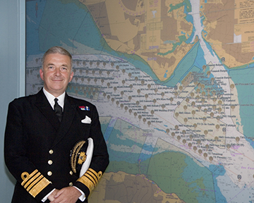
Admiral Sir Alan West, then First Sea Lord, is pictured with the official chart of anchorages for the International Fleet Review. (Photo: DP Kilfeather's book Trafalgar 200 Through the Lens Queen Elizabeth II 80th Birthday Edition, CC BY-SA 2.5)

Admiral Sir Alan West, then First Sea Lord, is pictured with the official chart of anchorages for the International Fleet Review. (Photo: DP Kilfeather’s book Trafalgar 200 Through the Lens, Queen Elizabeth II 80th Birthday Edition, CC BY-SA 2.5)

DG: How about the UK rejoining Galileo?

LW: Actually, that makes a lot of sense from a practical point of view for both the UK and Europe. Unfortunately, there were a lot of hurt feelings on the continent with Brexit, some EU leaders seemed to be in punishment mode, and expulsion from Galileo was part of the fallout. I think that in due course as tempers cool, we will fully re-engage with the European Space Agency.

DG: So, no UK project for a GPS equivalent?

LW: The government allocated £90 million to that, which enabled a thorough look at the idea but was woefully inadequate to even start a project. Doing a British version of GPS or Galileo would be hugely expensive and doesn’t make sense. There are better, cheaper ways of getting what we need.

DG: And what does the UK need? What is the goal?

LW: We need several things.

First, we need a global capability that is ours, or that we are closely partnered in, to support the UK’s worldwide military and economic interests.

We also need to have something in place so that, even if space is denied to us — and that is getting to be more and more of a threat each day — we can keep our industries, critical infrastructure and economy going at home.

And third, we need a resilient PNT capability as a foundation for current applications, and to build on for such things as autonomy, intelligent transportation, and the like.

DG: So how do you get there?

LW: For the global bit, the OneWeb, and perhaps an even closer partnership with the United States on GPS.

At home, we definitely need a sovereign capability for when space is denied by solar weather or our adversaries. Also to be a check on space signals because our adversaries and criminals are spoofing them more and more.

I have always thought eLoran was a good choice. The UK pioneered its development and had the world’s first operational system in 2015. It is really hard to interfere with the signal, and there are other features that could be added to it that would make it even more robust.

There was a very interesting report called MarRINav put out last year about what UK maritime needs to ensure it can navigate regardless of whether the satellites are working or not. They came up with a reasonably inexpensive combination of systems anchored by eLoran.

By the way, it is interesting that the MarRINav study was funded by the European Space Agency. They seem to understand that satellites are not the be all and end all for PNT services.

DG: That all seems pretty straightforward and the right thing to do. What’s standing in the way?

LW: Well, so few people understand the problem. The population as a whole is almost completely unaware. At some level government understands all 13 of our critical infrastructure sectors could be impacted, but the people senior enough to drive action have dozens of other issues to deal with that probably seem more urgent.

DG: I wonder what it will take to make it seem urgent enough.

LW: Let’s hope the wakeup call is something short of a national disaster.