A roundup of recent products in the GNSS and inertial positioning industry from the April 2020 issue of GPS World magazine.
OEM
LPWA module
Collaborative IoT SOLUTION
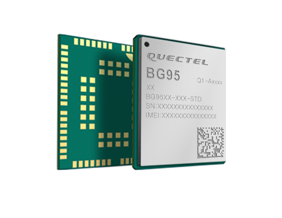
Photo: Quectel
Quectel Wireless Solutions’ LPWA module BG95 is being integrated with Microsoft’s Azure Device software development kit (SDK). The BG95 cellular module is based on the Qualcomm 9205 LTE modem. The integration will provide direct and secure connections to the Azure IoT Hub and provide full support for Azure device management. Customers can connect their BG95 devices to the Microsoft Azure cloud where they can build, manage and deploy internet of things (IoT) solutions at scale, significantly accelerating time to market. The BG95 module is a highly integrated variant supporting integrated GNSS, Cat M1, Cat NB2 and EGPRS (also called edge). The module complies with 3GPP Release 14 and delivers improved capabilities in power consumption, data rates and hardware-based security.
Quectel Wireless Solutions, quectel.com
Microsoft Azure, azure.microsoft.com
Qualcomm Technologies, qualcomm.com
Cell module
Integrated GNSS for LPWA IOT
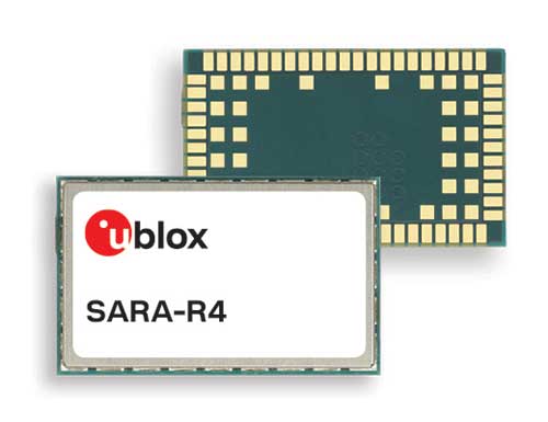
Photo: u-blox
The SARA-R422 product series of LTE-M/NB-IoT and EGPRS cellular modules now include GNSS variants for internet of things (IoT) data, devices and ecosystems. The SARA-R422M8S module is pre-integrated with the u-blox M8 GNSS receiver and a separate GNSS antenna interface. This provides highly reliable, accurate positioning data simultaneously with LTE communications. The module also supports hybrid positioning strategies, in which positioning data provided by satellite constellations is enhanced with data from the u-blox CellLocate service, ensuring that location data is always available everywhere. The SARA-R4 series is designed for a wide range of mission-critical IoT solutions such as connected healthcare, industrial monitoring, point of sale and vending terminals, tracking and telematics devices, as well as smart lighting solutions and building automation.
u-blox, u-blox.com
Emergency beacons
Line meets new Cospas-Sarsat requirements
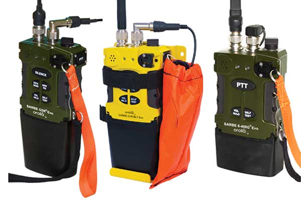
The new line of Sarbe search and rescue beacons. (Photo: Orolia)
Orolia has improved its Sarbe Evo search-and-rescue (SAR) beacon range line to deliver upgraded operational capabilities. The line offers new operational improvements to meet revised Cospas-Sarsat requirements in operating lifetime, location accuracy, voice signal management, integrated protocols, testability and maintenance. Also a focus of the upgrade was more robust and frequent GPS/GNSS position acquisition with the GPS, Galileo and GLONASS satellite constellations.
Orolia, orolia.com
GNSS monitoring
Fights jamming and spoofing

ADVA’s GNSS assurance solution could help companies dependent on satellite-based timing. (Photo: Business Wire)
ADVA’s GNSS assurance solution helps companies dependent on satellite-based timing. The centralized GNSS monitoring and assurance tool uses artificial intelligence and machine learning for comprehensive predictive maintenance. The customer-owned tool enables users to collect and analyze huge amounts of information from across the network to remotely identify issues and protect networks from GNSS vulnerabilities, including jamming and spoofing attacks. It also helps to identify GNSS obstruction issues, detect blind/poor spots that appear over time, and enable optimal antenna positioning. Built into ADVA’s Ensemble Controller network management suite with Sync Director, the solution enables customers to detect potential problems in advance and maintain the highest quality of network synchronization. It complements the limited distributed approach to GNSS assurance with a centralized global system, providing a boost to critical infrastructure now dependent on satellite-based timing.
ADVA, adva.com
Oscilloquartz, oscilloquartz.com
TRANSPORTATION
GNSS/MEMS module
Improves GNSS-denied positioning

Photo: Locosys
The Locosys MC-1612-DG is a single-band multi-system with an ARM-based processor that supports GPS, GLONASS, Galileo, QZSS and SBAS. The embedded micro-electro-mechanical systems (MEMS) sensor is equipped with dead-reckoning software and provides six-axis accelerometer and gyroscope data. The extended Kalman filter algorithm combines GNSS and MEMS sensor data with a weighting function that relies on GNSS signal quality. In adverse GNSS conditions such as urban canyons, tunnels or parking garages, the dead-reckoning features boost accuracy with the software filling the gaps. It supports three-dimensional dead-reckoning and standard NMEA output, and has Flash memory, TCXO, RTC crystal, LNA and SAW filter.
Locosys, locosystech.com
Automotive-grade lidar
25-beam solid-state family

The RS-Lidar-M1. (Photo: Robosense)
The automotive-grade solid-state RS-LiDAR-M1 family has the performance advantages of traditional mechanical lidar, while meeting requirements for mass-produced vehicles. The RS-LiDAR-M1Smart is embedded with an artificial intelligence perception algorithm that transforms conventional 3D lidar sensors into a full data analysis and comprehension system, outputting semantic-level structured environment information in real time for autonomous vehicle decision making. The RS-LiDAR-M1Smart outputs two redundant channels of data: the original point cloud and the object list. The redundacy provides vehicles with a range of sensing results — dynamic, static, inside and outside the road. Also available is the RS-LiDAR-M1Simple.
RoboSense, robosense.ai
MACHINE CONTROL
GNSS receiver
For excavators, drills, pile drivers

Photo: Carlson
The Vsx7 multi-frequency position and heading receiver is designed specifically for machine control and can be mounted by bolts or with magnets on heavy equipment. Paired with the Carlson A45 antennas, the Vsx7 features high-precision positioning in Athena RTK, Atlas L-band and SBAS and heading accuracy of up to .01 degrees. The whole Vsx7 system is designed to operate in harsh conditions from –40° F to +158° F. The Vsx7 is primarily used in the mining and construction industries, but can be used in similar industries with companion software, Carlson Grade. Field data can be collected and viewed in real time both at the machine with either the MC8 or MC10 control box as well as in the office with Carlson Command.
Carlson Machine Control, carlsonsw.com
SaaS operating system
Cloud-based, integrates data

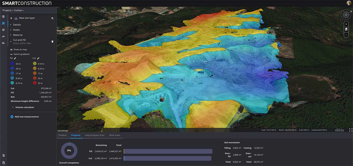
Screenshot: Trimble
Trimble WorksOS is a new Software-as-a-Service (SaaS) operating system. The cloud-based system will integrate data from Trimble and third-party providers across the entire civil construction project lifecycle, including estimating, scheduling, designs and the field. Currently, site supervisors and project managers jump between multiple systems to keep track of daily production quantities, labor/equipment hours and equipment maintenance schedules. Works OS is designed to bring real-time visibility into jobsite progress, schedule and cost. Users will be able to log into a single application to view real-time visibility of cut, fill, volume and compaction data to maximize jobsite productivity. Site supervisors will see daily volume calculations and compaction quality metrics, and be able to monitor progress and schedules.
Trimble, trimble.com
MAPPING
3D dashboard
Powers smart construction
Screenshot: Cesium
Komatsu’s Smart Construction dashboard includes the 3D visualization power and geospatial accuracy of Cesium, a platform to visualize, analyze and share 3D data. The dashboard enables users to monitor a construction site from anywhere in the world, see how it changes over time, and compare architectural plans with real-world data. It is compatible with data from sensors on construction machines, drone surveys, or computer-generated files like BIM/CAD models . It allows users to visualize projects in a single scene within a web browser, as well as calculate precise measurements for cut and fill, slope, contours and more.
Cesium, cesium.com
Komatsu, komatsuamerica.com
Web app
For utilities and infrastructure
Image: MGISS
The TopoGrafi app has been updated to allow for display of 3D data in real-world models. With enhanced 3D data-processing capabilities, TopoGrafi is an end-to-end platform for capturing buried asset data and processing it for augmented reality visualizations. Designed to be used alongside apps such as Esri Collector for ArcGIS, the TopoGrafi platform uses GNSS data. It applies near-real-time conversions, transforming the recorded positions to local reference systems and aligning it with high-accuracy mapping including Ordnance Survey MasterMap. The TopoGrafi toolkit also includes functionality to snap 3D features to each other and to other spatially referenced data to create a 3D model that can then be used to create augmented reality visualizations accessible from the desktop or in the field.
MGISS, mgiss.co.uk
SURVEYING
Drone data import
For surveyors and geospatial professionals
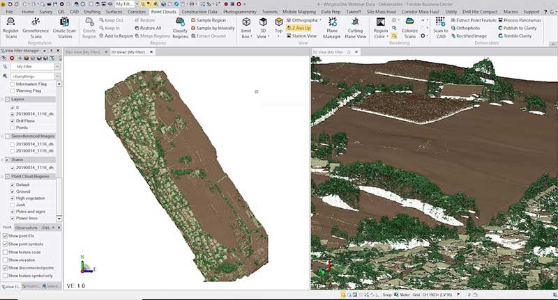
Photo: Wingtra
WingtraOne drone data can now be directly imported into the Trimble Business Center (TBC). The new integration combines WingtraOne high-accuracy drone data within TBC, optimizing drone mapping workflows for survey and construction projects within a single software platform. After dragging and dropping the JobXML data file, automated point cloud tools, such as classification and feature extraction, can quickly generate surface models, topographic plans and as-built deliverables. Also new: high-altitude flight capabilities, longer flight times and more intuitive battery-level readings in-flight.
Wingtra, wingtra.com
Trimble, geospatial.trimble.com
Scanning system
Can be mounted on backpacks, vehicles or uavs
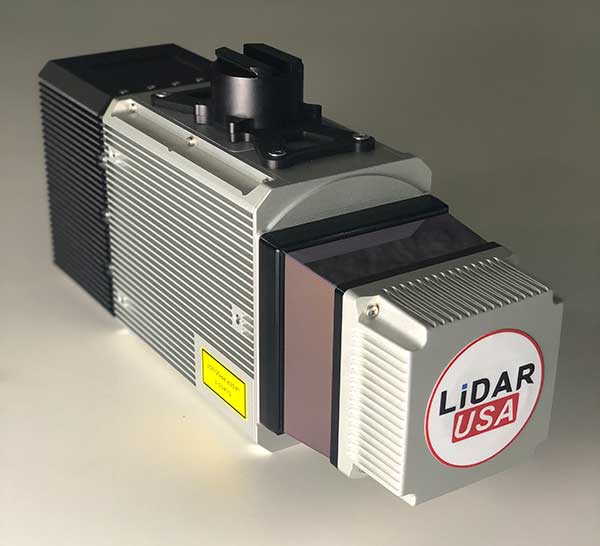
The Snoopy CL-360 lidar scanner. (Photo: Lidar USA)
The Snoopy CL-360 has been meticulously designed for integration on backpack, vehicle and UAV applications. Weighing 5 kilograms fully assembled, the Snoopy CL-360 is capable of delivering highly accurate results, up to +/-0.01 feet on paved surfaces from a vehicle. The system has a scan line rate of 250 Hz with a 500-kHz data rate, giving a uniform result along and across track. The system is easily configurable with multiple scanners (similar to internet of things applications) to avoid occlusions. A UAV deployment achieves scans with usable data as much as 60 degrees off nadir (widths of more than 1,100 feet while scanning at the 400-foot ceiling). The small beam size of 0.3 mrad allows the CL-series to reliably collect ground points (such as on or near the dirt through vegetation) while also providing better detection of fine linear features such as power lines and railroad tracks.
Lidar USA, www.lidarusa.com
GNSS + inertial receiver
Dynamic GNSS receiver for professionals
Photo: E-Compass
The E300 Pro receiver tracks GNSS with 700 channels and fully supports BDS-3 signals. It supports 31 frequency points, using all GNSS constellations and frequency bands. The E300 interface has a concealed design for better protection. USB type-C charging and transmitting is a two-in-one function. The magnesium-alloy body is rugged, and the battery level can be checked with a unique LED power indicator. The weight of the whole receiver is 940 grams. The E300 Pro supports satellite station differential and satellite chain life, quick connection, intelligent voice and tilt compensation. It integrates multiple sensors including GNSS, an inertial measurement unit (IMU), a magnetometer and a thermometer. With the help of a Kalman filter algorithm, the device can dynamically output position, speed and attitude information. It can measure and make real-time dynamic sampling without the need for leveling. For better radio signal quality, the E300 Pro integrates GNSS, Bluetooth, Wi-Fi, 4G main and auxiliary antennas on the top of the receiver to ensure the best reception in all directions. An RF connector improves connection reliability while reducing loss of gain.
E-Compass Science & Technology, esurvey-gnss.com
GNSS/scanning station
Combines GNSS and 3D scanning

Photo: Leica Geosystems
The Nova MS60 MultiStation combines upgraded, fast 3D laser-scanning capabilities, GNSS connectivity and digital imaging with a high-end total station. It features a fast laser-scanning speed of up to 30,000 points per second, optimized scan area definitions, adapted scan managements, and an improved scanning path for zenith scans. Professionals can perform point-cloud analysis in the field. Scan data is combined with traditionally measured points from GNSS receivers to graphically show locations the same day it is collected.
Leica Geosystems, leica-geosystems.com
UAV
Defense UAS
Designed for demanding environments
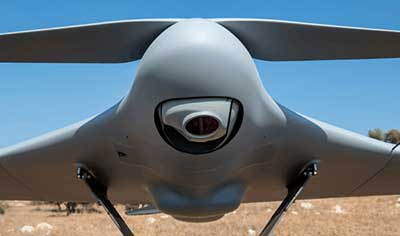
Photo: CP Aeronautics
CP Aeronautics, a new division of CP Technologies, has launched integrated turn-key solutions based on unmanned aerial systems (UAS) platforms, payloads, data links, ground control stations (GCS) and communications for defense and civil applications. The systems offer operationally proven solutions for intelligence, surveillance and reconnaissance (ISR) systems requirements. Its broad product portfolio has demonstrated excellent performance and operability in demanding environments, the company stated in a press release. Backed by continuous research and development, the systems are built on three decades of technological and operational experience. Systems include Orbiter 2 Small UAS, Orbiter 3 Small Tactical UAS, Orbiter 4 Small Tactical UAS (pictured), Aerostar Tactical UAS, Dominator XP (medium-altitude long-endurance) and Pegasus 120 (vertical takeoff and landing).
CP Aeronautics, cp-aeronautics.com
Flight control system
For multi-mission, multi-domain UAV platforms
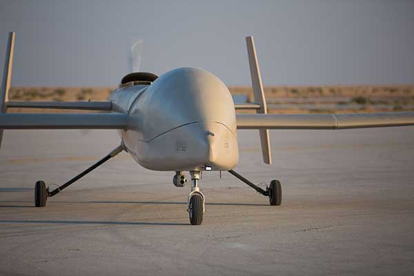
Photo: UAVOS
A new flight control system (FCS) fits and leverages multi-mission, multi-domain UAV platforms. Using the FCS, the new Saker-1B Medium Altitude Long Endurance (MALE) UAV performs with fully autonomous online and offline operation, from takeoff to landing. Testing included more than 500 hours of day and night test missions under various weather conditions, including extremes of dust and heat. A total of 1,000 hours of take-off and landing test missions were successfully performed, with long-endurance flights lasting up to 19 hours. The Saker-1B is equipped with a satellite communication data link for beyond-visual-line-of-sight (BVLOS) operation. The FCS provides sustainability to jamming attacks and advanced data security.
UAVOS, uavos.com
King Abdulaziz City for Science and Technology, kacst.edu.sa
Drone monitor
Counter UAS system for dense urban environments
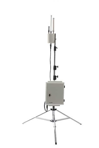
Photo: Vorpal
VigilAir is an RF-based system of deployed sensors able to accurately detect, geolocate and track commercial drones and their operators in different environments, including dense urban environments. VigilAir provides extremely sensitive detection and highly accurate geolocation and tracking over very large areas, with virtually zero false-alarms. Being a passive, receive-only system, VigilAir can easily be installed and operated without regulatory or legal limitations. The VigilAir version 2.0 C-UAS (counter unmanned aerial system) is certified by the United Kingdom Center for the Protection of National Infrastructure (CPNI) under the CPNI’s Counter Unmanned Aerial Systems Detect, Track and Identify (DTI) testing and evaluation standard. VigilAir generates a comprehensive drone situational awareness which enables users to proactively and intelligently match correct mitigation actions with actual drone threats, on time and with minimal collateral effects.
Vorpal, vorpal-corp.com
Counter-UAV system
Detect, identify, control, act
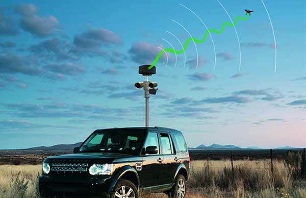
Photo: Hensoldt
Xpeller Rapid — the mobile version of the counter UAV solution Xpeller — uses a combination of radar, electro-optical sensors, rangefinders and jammers to protect against threats posed by over-the-counter drones. Xpeller Rapid is either integrated into a vehicle (mast solution) or comes in transport boxes and can be easily set up on tripods. Based on the Xpeller toolkit, the components follow the detect, identify, control and act workflow, defeating hostile drones at ranges up to several kilometers. The system can locate and classify even small hobby drones at a range of several kilometers. High-resolution cameras make it possible to decide whether there is a serious threat so that it can be countered with appropriate countermeasures.
Hensoldt, hensoldt.net