A roundup of recent products in the GNSS and inertial positioning industry from the November 2019 issue of GPS World magazine.
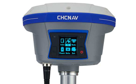
IMU-RTK receiver
Increases GNSS availability and reliability
The i90 IMU-RTK GNSS series receiver is designed to dramatically increase GNSS real-time kinematic (RTK) availability and reliability. The i90 is powered by the company’s latest inertial measurement unit (IMU) and RTK technology to provide robust and accurate GNSS positioning in any circumstances. Unlike standard micro-electro-mechanical (MEMS)-based GNSS receivers, the i90 GNSS IMU-RTK combines a high-end calibration and interference-free IMU sensor with a state-of-the-art GNSS RTK engine and advanced GNSS tracking capabilities. The i90 is designed to increase the productivity and reliability of survey projects, with no complicated calibration process, rotation, leveling or accessories are necessary. A few meters’ walk will initialize the i90 internal IMU sensor and enable RTK survey in difficult field environments. The i90 GNSS automatic pole-tilt compensation boosts survey and stakeout speed by up to 20%.
CHC Navigation, chcnav.com
GNSS/INS System
Both accurate and rugged for machine control, logistics

The AsteRX-SBi has a rugged housing, making it suitable for machine control and other outdoor uses. (Photo: Septentrio)
Septentrio has expanded its GNSS/INS portfolio with the AsteRx SBi, a new housed GNSS/INS receiver. The ruggedized AsteRx SBi fuses high-accuracy GPS/GNSS with a high-performance inertial sensor to provide reliable positioning and 3D orientation for machine control and logistic applications. Within its rugged, waterproof enclosure, a high-performance GPS/GNSS is coupled with an industrial-grade inertial sensor to provide high-accuracy, reliable positioning and 3D orientation (heading, pitch, roll). Offering the flexibility of either single or dual antenna, the AsteRx SBi is designed for quick and easy integration into any machine monitoring or control system. Reliable location and 3D orientation data is streamed with a high update rate and constant low latency. Septentrio’s reliable centimeter-level positioning is based on true multi-frequency, multi-constellation GNSS (GPS, GLONASS, Galileo, BeiDou, QZSS) technology.
Septentrio, septentrio.com
Scanning System
For surveying, construction
The Trimble X7 laser scanning system is designed for surveying, construction, industrial and forensic applications. It enables professionals to quickly and easily capture precise 3D scanning data to produce high-quality deliverables. The X7 features Trimble X-Drive technology, survey-grade self-leveling and a smart calibration system. It integrates streamlined workflows to provide automatic registration of point-cloud data in the field with Trimble Registration Assist, bringing scans together through self-leveling inertial measurement unit technologies and cloud-based software.
Trimble, trimble.com
City mapping
Service offered for Europe

The Bluesky MetroVista range includes high-resolution imagery combined with high-accuracy, wide-scale 3D models. (Image: Bluesky)
The MetroVista city mapping service for Europe incorporates the Leica CityMapper hybrid airborne sensor designed for 3D city modeling and urban mapping. The sensor includes a vertical camera and survey-grade oblique cameras, and incorporates lidar to accurately collect elevation and infrared data. The MetroVista range includes high-resolution imagery combined with high-accuracy, wide-scale 3D models. CityMapper has already been used to capture MetroVista data for cities across the United Kingdom, including London, Manchester, Newcastle and Bristol.
Bluesky International, bluesky-world.com
Simulation solution
Updated for high-accuracy market
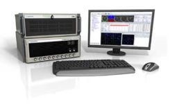
The enhanced GSS9000 series GNSS constellation simulator has been updated to provide significantly improved capability, flexibility and performance to meet the test needs of high-performance navigation systems. It doubles the number of supported channels (320 in a single chassis) while maintaining its full performance specification in key areas such as signal iteration rate and low latency under maximum signal dynamics. These attributes, together with the ability to produce a comprehensive range of emulated multi-GNSS, multi-frequency RF signals, enables full and future-proofed testing of advanced applications. Greater signal flexibility is also built into the enhanced GSS9000 through its open application program interface (API) and flexible architecture. This delivers a highly sophisticated arbitrary waveform generator (AWG) capability.
Spirent Communications, spirent.com
NavIC support
Added to constellation data service
Rx Networks has added NavIC constellation support to its real-time and predicted-assistance data service. The company’s technology partners — semiconductor vendors, mass-market mobile device manufacturers and network operators — now have global support for all satellite navigation systems and L1 satellite-based augmentation systems (SBAS) for any region around the world. Used daily by more than two billion devices, Rx Networks data is delivered via ephemeris in RINEX and via the Location.io interface, with predictions in SP3. Predictions for NavIC via the Location.io platform will be added in the first quarter of 2020.
Rx Networks, rxnetworks.com
MEMS timing
For rugged GNSS applications
Endura micro-electro-mechanical system (MEMS) timing solutions are designed for aerospace and defense applications including precision GNSS. They provide high performance in harsh conditions such as severe shock, vibration and extreme temperature. SiTime offers customers 5 million possible part numbers that can be created from 17 programmable products. Solutions accommodate 4 parts per trillion per g force of acceleration (50 times better than quartz); support for –55° C and +125° C operation; timing specifications conforming to MIL-PRF-55310; and Endura Super-TCXOs (temperature compensated oscillators) for use in GNSS applications.
SiTime, sitime.com
GNSS RF Simulator
Record and playback system
Portos Team is a new GNSS RF signal record-and-playback system. It can record and play back — or simulate —multi-frequency, multi-system GNSS signals when paired with the company’s Replicator. It can do the same for CRPA signals when paired with the company’s Ninja. The Portos itself can also operate as multi-frequency or CRPA front end for a GNSS software receiver.
IP-Solutions, ip-solutions.jp
UWB module
For real-time location systems
The DWM1004 module targets time difference of arrival (TDoA) tag applications that require years of battery life and a compact design. Based on the DW1000 chipset, the DWM1004C offers high-accuracy, real-time-location capability with a 6.8-Mbps data rate. It delivers more than five years of battery life. Real-time location systems (RTLS) enable managers to have a real-time view of their operations through data collected from connected objects such as tools, pallets, forklifts, badges and collars. The DW1000 is immune to multipath fading, with 2-centimeter precision in indoor environments.
Decawave, decawave.com
RTK GNSS Rover
GNSS for a moving vehicle
The F9P Sirius RTK GNSS rover is designed to be mounted on a moving vehicle. The u-blox ZED-F9P module inside provides 1-cm position accuracy, a convergence time under 10 seconds and a navigation update rate up to 20 Hz. The rover has a built-in active antenna patch. It receives GPS, Galileo, Beidou and GLONASS signals, providing additional accuracy. It is designed to fit most setup designs as well as integrate easily into a vehicle. Its six-pin JST-GH connector makes it plug-and-play with the Pixhawk Pro 3 autopilot.
Drotek Electronics, drotek.com
GNSS Datalogger
Accuracy for automotive testing
The VBOX Touch is a highly flexible GNSS datalogger with enhanced accuracy. The powerful hardware can be used diverse automotive tests such as acceleration, braking, speed verification, tire temperature monitoring, lap-timing and durability. The VBOX Touch comes preloaded with a sophisticated performance application that covers common use cases; applications can be downloaded from an online library. Racelogic can also write custom Python scripts based on customer requirements.
Racelogic, www.vboxautomotive.co.uk
Positioning module
Designed for auto industry
The LG69T GNSS module is an automotive-grade dual-band high-precision GNSS module that integrates dead-reckoning (DR) and real-time kinematic (RTK) technologies. The module facilitates open-sky positioning performance with an accuracy of up to 10 centimeters. It supports next-generation precision positioning capabilities for smart vehicles and autonomous driving scenarios. The LG69T module is based on ST’s STA8100GA, the latest automotive-grade dual-frequency positioning chip with 80 tracking channels and four rapid-acquisition channels compatible with GPS, BeiDou, Galileo, Navic and QZSS. The AEC-Q100-qualified dual-band module integrates multi-band RTK technology for centimeter-level accuracy. The LG69T module’s dead-reckoning capabilities feature an integrated inertial measurement unit (IMU) that provides continuous high-precision positioning.
Quectel Wireless Solutions, quectel.com
STMicroelectronics, st.com
Combo antenna
For advanced rail communications
The Coach II antenna with GNSS L1/L2/L5 is designed to provide greater precision and reliability for advanced rail communications systems, enabling next-generation positive train control (PTC) and passenger Wi-Fi. The Coach II features global multi-GNSS compatibility, dual-port 4G LTE / sub-6 GHz 5G NR and 802.11ac Wi-Fi / Bluetooth connectivity. It is AAR compliant for railway applications and is IP67-rated.
PCTEL, www.pctel.com
Firmware update
Includes new automotive package for Ellipse GNSS/IMU products
New features have been added to the Ellipse product line with firmware update version 1.7. The update better answers needs of the autonomous testing and driving markets such as a CAN odometer. Users now have the choice to connect an external odometer (DMI) with pulses or use their car odometer with velocity information. New outputs include body velocity and slip angle, which calculate the drift angle between the vehicle’s assumed trajectory and its actual trajectory. For precision applications as well as low dynamics and reduced warm-up time, the new firmware allows users to run the Ellipse Kalman filter with no lever-arm estimation. This will ensure centimeter pass-to-pass accuracy for real-time kinematic (RTK) applications and allow operation in lower dynamics while reducing warm-up time. The firmware update also provides new features for advanced marine applications.
SBG Systems, www.sbg-systems.com


