Publicerad den Lämna en kommentar

GPSdome: Industry’s Most Disruptive GPS Anti-Jammer

[SPONSORED CONTENT] GPS jamming has become the #1 threat to defense and commercial drones. Therefore we developed GPSdome: a GPS protection solution tailored for defending drones and vehicles from jamming attacks. GPSdome provides a robust cyber shield, allowing the protected platform to safely and continuously operate and complete missions in a GPS-challenged environment. At its minimal size weight and power, there is no other solution that offers such protection as small, light, affordable or as easily installed as GPSdome.

Learn more.

This video is sponsored content from Infinidome.

Publicerad den Lämna en kommentar

Navigation company iXBlue acquired by Groupe Gorgé

Photo: ixBlue

Photo: ixBlue

Groupe Gorgé has acquired navigation company iXblue. The move will bring iXblue and Groupe Gorgé subsidiary ECA Group and iXblue.

Groupe Gorgé is a European company specializing in high-tech industrial solutions for the robotics, maritime, navigation, aerospace and photonics markets. Together, iXblue and ECA Group will provide customers with components and complex systems to support critical missions in severe environments.

The two companies will have a global workforce of 1,500 people and will achieve an annual turnover of €250 million.

“In addition to our complementary activities, both our companies share a common DNA centered around innovation and entrepreneurship,” said Fabien Napolitano, president and CEO of iXblue. “This acquisition by Groupe Gorgé, which puts iXblue and ECA Group under the same roof, will enable us to create new synergies and strengthen our capacity to invest in research and development to offer solutions that are always at the cutting edge of technology.”

Dominique Giannoni, CEO of ECA Group, added, “With the combination of the technological expertise and global footprint of the two companies, we will provide unmatched value to our customers through our comprehensive portfolio of products and solutions. This operation consolidates our leadership in our markets and offers excellent growth prospects. The teams of our two companies have already started working closely together. We see great development opportunities that we are eager to share with our customers.”

Publicerad den Lämna en kommentar

ION ITM/PTTI 2023 abstracts due October 7

Logo: IONAbstracts for ION ITM/PTTI 2023 are due Friday, October 7.

Submit your abstract for the Institute of Navigation’s (ION) combined International Technical Meeting (ITM) and the Precise Time and Time Interval (PTTI) Systems and Applications Meeting 2023. The co-located conferences will take place January 23-26 at the Hyatt Regency Long Beach, Long Beach, California. Both in-person and virtual presentation options will be available.

The International Technical Meeting (ITM), is is the ION’s winter meeting, with technical papers related to positioning, navigation and timing and includes the ION Fellows and Annual Awards presentations.

The Precise Time and Time Interval Systems and Applications (PTTI) meeting is an annual conference sponsored by ION with a technical program designed to disseminate and coordinate PTTI information at the user level, review present and future PTTI requirements, inform government and industry engineers, technicians, and managers of precise time and frequency technology and its problems, and provide an opportunity for an active exchange of new technology associated with PTTI.

Publicerad den Lämna en kommentar

Space Tech Expo Europe to showcase industry trends

Space Tech Expo Europe will make its return to Bremen, Germany November 15-17.  The full agenda has been released, detailing the speakers, sessions and pressing topics that will help to shape the future of a thriving space industry.

Space Tech Expo Europe provides attendees with fundamental knowledge on current industry trends, challenges, and opportunities in unmissable discussions from technical-level experts from across the supply chain. The expo boasts over 100 speakers, over 450 exhibitors and three separate conferences over three days.

Conferences

The Industry Conference at Space Tech Expo Europe provides audiences with critical insights into the latest updates and key trends happening in the European (and beyond) space sector, aiming to help shape the future of our thriving industry.

Sessions taking place at the Industry Conference will shed light on the sector’s most pressing matters, including industry developments, investment, space exploration, launch, digitalization, the in-space supply chain, space sustainability, and much more.

The Smallsats Conference at Space Tech Expo Europe enables the small satellite community to meet and explore the most exciting developments in the market. Here, the upstream small satellite technology providers, downstream service providers and end-users come together to address the sector’s biggest trends. Topics will include launch and propulsion, increasing satellite manufacturing capabilities, standardization, exploring downstream applications of remote sensing data, creating actionable data insights, and space cyber security.

The Mobility Connectivity Conference at Space Tech Expo Europe bridges the gap between merchant shipping, cruise shipping and commercial aviation’s connectivity requirements, and the technical solutions satellite operators, service providers and ground network providers can now offer through a developing and maturing space and ground technology infrastructure.

Topics include passenger expectations following the pandemic, crew welfare optimization through advanced communication systems, high-data transfer in remote areas, optimized terminals and antennas, hybrid network solutions and advanced onboard communication technology.

The full agenda for all conferences can be found at https://www.spacetechexpo-europe.com/conference/conference-agenda.

Registration is still open for the event. To attend Europe’s largest exhibition and conference for the aerospace industry visit https://www.spacetechexpo-europe.com/register-now.

Publicerad den Lämna en kommentar

Plugin Update September 2022

The QGIS plugin repository currently lists 1710 plugins and the list keeps on growing. September has been busy with 16 new plugins. It can be challenging to stay up to date.

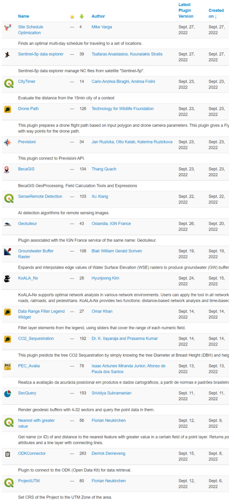
Our monthly plugin update is meant to provide you a quick overview of the newest plugins. If any of the names or short descriptions piques your interest, you can find the direct link to the plugin page in the table below the screenshot.

Site Schedule Optimization
Finds an optimal multi-day schedule for traveling to a set of locations.
Sentinel-5p data explorer
Sentinel-5p data explorer manage NC files from satellite “Sentinel-5p”.
CityTimer
Evaluate the distance from the 15min city of a context
Drone Path
This plugin prepares a drone flight path based on input polygon and drone camera parameters. This plugin gives a Fly Litchi compatible csv file with way points for the drone path.
Previsioni
This plugin connect to Previsioni API.
BecaGIS
BecaGIS GeoProcessing, Field Calculation Tools and Expressions
SenseRemote Detection
AI detection algorithms for remote sensing images.
Geotuileur
Plugin associated with the IGN France service of the same name: Geotuileur.
Groundwater Buffer Raster
Expands and interpolates edge values of Water Surface Elevation (WSE) rasters to produce groundwater (GW) buffer rasters
KoALA_Nx
KoALA-Nx supports optimal network analysis in various network environments. Users can apply the tool in all network environments, such as roads, railroads, and pedestrians. KoALA-Nx provides two functions: distance-based network analysis and time-based network analysis
Data Range Filter Legend Widget
Filter layer elements from the legend, using sliders that cover the range of each numeric field.
CO2_Sequestration
This plugin predicts the tree CO2 Sequestration by simply knowing the tree Diameter at Breast Height (DBH) and height of the tree.
PEC_Avalia
Realiza a avaliação da acurácia posicional em produtos e dados cartográficos, a partir de normas e padrões brasileiros
SecQuery
Render geodesic buffers with 4-32 sectors and query the point data in them.
Nearest with greater value
Get name (or ID) of and distance to the nearest feature with greater value in a certain field of a point layer. Returns point layer with added attributes and a line layer with connecting lines.
ODKConnector
Plugin to connect to the ODK (Open Data Kit) for data retrieval.

Nyhet från QGIS, orginal inlägg

Publicerad den Lämna en kommentar

M3 Systems, Pipistrel and Volocopter complete air traffic tests in France

The flight test is the third of several to simulate a variety of real-world scenarios that demonstrate how UTM and ATM intersect with multiple aircraft types.

M3 Systems, Pipistrel and Volocopter have completed their first joint flight test campaign in France at Pontoise airfield.

The week-long flight tests simulated three different avoidance maneuvers in real-world situations where unforeseen circumstances occur, such as a complete airport or vertiport closure, an unavailable final approach and takeoff area, and traffic deconfliction.

M3 Systems was created from engineering activities in GNSS and consulting activities in air traffic management (ATM), including for uncrewed aircraft. M3 played a role in Galileo signal definition, among other projects for Europe’s various space agencies. Pipstrel is a light aircraft manufacturer specializing in electric propulsion, and Volocopter specializes in urban air mobility (UAM) systems.

The joint campaign among the three companies — with French partners Groupe ADP and its subsidiary Hologarde — aimed to achieve smooth interaction within and between the new lower airspace’s unmanned traffic management (UTM) and standard civil aviation ATM systems.
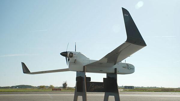
The Boreal system is a fixed-wing UAV with high-endurance and heavy payload capacity. (Photo: M3 Systems)

The Boreal system is a fixed-wing UAV with high-endurance and heavy payload capacity. (Photo: M3 Systems)

The aviation industry is experiencing an innovation upsurge driven by technology and societal pressure for new forms of aviation focused on sustainable, digital and autonomous air mobility. The resulting solutions will generate a significant increase in traffic density in the lower airspace.

Because existing ATM systems are not designed to handle such volumes or digitalization, coordinating existing and new traffic management systems for brand-new aircraft integration will ensure efficient large-scale operations. This includes commercial, general and drone aircraft for cargo and passenger flights, both crewed and uncrewed.

The CORUS-XUAM project, funded by the European Union’s initiative Single European Sky ATM Research (SESAR) Joint Undertaking, focuses on solving the challenge of conventional and new traffic management system integration and consists of 19 partners and 11 third parties. M3 Systems, Pipistrel and Volocopter all completed individual flight-test campaigns before this event to bring their aircraft in line with the U-space services.

A week of flight tests ended with an Open Day air show and presentations. (Photo: M3 Mobility)

A week of flight tests ended with an Open Day air show and presentations. (Photo: M3 Mobility)

The CORUS-XUAM flight test conducted at Pontoise airfield near Paris is the third of several flight tests to simulate a variety of real-world scenarios that demonstrate how UTM and ATM intersect with multiple aircraft types.

Moreover, the CORUS-XUAM project will continue to proactively test and create a safe and controlled lower airspace under the European Union’s ambitious Single European Sky (SES) initiative throughout 2022.

The successful flight tests at Pontoise airfield were conducted with M3 System’s Boreal remotely piloted aircraft system, Pipistrel’s crewed Velis Electro, the only type-certified electric aircraft in commercial service in the world, and Volocopter’s fullscale, remotely piloted 2X prototype. Pipistrel uses the conventional ATM tower and system while Volocopter and M3 Systems use the UTM system. The following three flight scenarios were tested:

  • The unexpected occupancy of a final-approach-and-takeoff plan and aircraft diversion because of priority landing of another aircraft (Pipistrel and Volocopter aircraft).
  • The diversion of a flight path because of the closure of an airport or vertiport (M3 Systems).
  • The diversion of a flight path with two aircraft flying the same path (M3 Systems and Volocopter aircraft).

“These successful tests confirm that our Boreal UAS will be an enabler for future XUAM operations in situations where aircraft need to safely divert paths to another vertiport due to an unforeseen closure or another aircraft in the air,” explained Marc Pollina, M3 Systems CEO. “By providing rerouting demonstrations and tactical communications with U-Space service providers, M3 Systems can support future coordination between AAM and airport operators.”

Pipistrel is “As the manufacturer of the only type-certified electric aircraft in commercial service in the world, proud to take part in technical projects that shape the vision of air mobility and make progress in a meaningful way,” said Gabriel Massey, Pipistrel president. “The CORUS project and Paris demonstrations clearly show how UAM vehicles will be able to fly safely in regular airspace post-2030 and will help to unlock new lower-noise and lower-emission air passenger and air cargo services.”

In 2019, Volocopter tested its 2X ATM integration at Helsinki airport and was actively involved in the development of the European U-Space Concept of Operations, according to Oliver Reinhardt, Volocopter’s chief risk and certification officer. “Building an efficient ecosystem around UAM is Volocopter’s mission, and connecting ATM/UTM integration with our digital platform, VoloIQ, is poised to be an integral part of bringing UAM to megacities worldwide,” Reinhardt said. “I am looking forward to the next CORUS-XUAM test flights later this year in Germany and what we can achieve there.”

The project has received funding from the SESAR Joint Undertaking under the European Union’s Horizon 2020 research and innovation program under grant agreement No. 101017682.

Publicerad den Lämna en kommentar

AUVSI works with Defense on cybersecurity certification for commercial drones

AUVSI’s Trusted Cyber Program will offer commercial drone certification based on DIU Blue UAS methodology

Blue UAS logoThe Association for Uncrewed Vehicle Systems International (AUVSI) is collaborating with the Defense Innovation Unit (DIU) to further commercial cyber methodologies to build a shared standard. The standard would be similar to one used to develop DIU’s Blue UAS Cleared List.

AUVSI’s effort is designed to expand the number of vetted uncrewed aircraft systems (UAS) that meet congressional and federal agency drone security requirements.

DIU accelerates commercial technology for national security. Its Blue UAS program launched in 2021 is aimed at prototyping and scaling capable and secure commercial UAS technology for the Department of Defense (DOD).

“The goal of this new pilot initiative is to extend relevant cyber credentialing across the U.S. industrial base, proactively, streamlining and accelerating capabilities available to the DOD and the rest of the U.S. government,” said Brian Wynne, AUVSI president and CEO. “We are grateful for DIU’s partnership and look forward to working with them to make the U.S. drone industry more resilient and secure.”

AUVSI efforts will streamline the vetting process and expand potential small UAS entrants to the government through its Trusted Cyber Program. The industry-led cyber compliance effort will work with a suite of cybersecurity firms to provide technical cyber assessments. DIU, DOD and other government organizations can then conduct additional vetting if needed.

The Blue UAS program has helped establish a cybersecurity baseline and coordinate government efforts to streamline the approval process for commercially available NDAA-compliant drones. Thirteen drones are scheduled to be added to the Blue UAS Cleared List, but demand for additional cleared drones with new capabilities has outpaced DIU’s ability to scale this critical program, because of limited funding and manpower. Because of its unique position in the market, AUVSI and its Trusted Cyber Program will provide this cybersecurity certification pathway to the commercial industry in close coordination with DIU.

“Commercial-off-the-shelf UAS are increasingly relied upon by federal agencies as critical tools to conduct diverse operations,” said David Michelson, DIU program manager for Blue UAS. “Partnerships with industry that make it easier for federal users to access commercial technology will help achieve the program’s goals.”

Publicerad den Lämna en kommentar

Tallymatics launches TW5390 antenna with IP network and L-band capability

Photo: Tallymatics

Photo: Tallymatics

Tallymatics has introduced the TW5390 smart antenna with IP network and L-band augmentation service capability.

Tallymatics is a division Tallysman Wireless, a Calian company, specializing in of precision geolocation applications and equipment.

To create the TW5390, Tallymatics leveraged its experience in GNSS applications, design and manufacturing,  combining Tallysman’s GNSS antenna technology with the high-precision u-blox F9R GNSS receiver and DS9 L-Band receiver modules.

The combination delivers a reliable and convenient smart antenna yielding <6 cm accuracy, with precise point positioning/real-time kinematic (PPP/RTK) augmentation services via the PointPerfect subscription service.

The TW5390 solves the complexities of GNSS design — it sends the host system PPP/RTK corrected coordinates in NMEA format over a robust RS-485 interface, assuring results that meet customers’ high expectations.

Features of the TW5390

  • simultaneous dual-band coverage for GPS, Galileo, GLONASS and BeiDou
  • superior multipath rejection with Tallysman Accutenna technology
  • low noise amplifier
  • Tallysman’s eXtended Filtering (XF) technology, which mitigates saturation from nearby RF signals (targeting
  • LTE and Ligado)
  • tight, measured phase-center offset and low axial ratio, enabling accurate and precise positioning
  • direct decoding of PointPerfect, SPARTN formatted augmentation packets (u-blox specific)
  • IP network and L-band augmentation communications channels
  • built-in inertial measurement unit for UDR and ADR
  • fast convergence time of 40 seconds (PPP/RTK) with < 6 cm accuracy
  • IP69K package
  • RS-485 transceivers
  • Tallymatics SDK available with computer interface, TruPrecision software and 60 days of free PointPerfect
  • service
  • cable lengths of 5, 15 and 25 meters
  • rugged, fixed mount
Publicerad den Lämna en kommentar

Continuous evolution – What is new with GNSS receivers?

GNSS receivers face the same old challenges (extremely weak received signal, orbit and satellite clock errors, ionospheric and tropospheric delays, multipath, dilution of precision, urban canyons, etc.) and new ones (increased interference). However, compared with just a few years ago, they benefit from new signals, many more satellites, a panoply of options for corrections, and improved integration with inertial navigation systems (INS).

For example, pole-tilt compensation is quickly becoming standard. This feature enables users to locate dangerous or hard-to-reach points by measuring them at an angle with just the tip of the pole to which the receiver is attached.

Pole-tilt compensation also makes surveying and mapping easier by removing, in many situations, the need to use total stations or offsets. Together with improvements in work processes, this makes GNSS receivers more user friendly. This is particularly welcome now that more surveyors are retiring than there are new surveyors entering the profession.

The greater accuracy of GNSS receivers enabled by the increase in the number and quality of satellites, signals, corrections services and integration of GNSS with other sensors is also increasing the number of use cases, especially at the high end of the accuracy requirements, such as lane-level vehicle navigation. (Next month’s cover story will center on this year’s Google Smartphone Decimeter Challenge contest, in which competing teams aim to bring smartphone location down to the decimeter or even centimeter resolution using raw location measurements from Android smartphones. This could enable services that require lane-level accuracy, such as estimated time of arrival when using a high-occupancy vehicle lane.)

This month’s cover story highlights what has changed “inside the box” to improve the accuracy and resilience of GNSS receivers for surveying, mapping and a variety of other applications. Read the success stories from five different companies below.

Swift Navigation: Driving safety for consumers

CHC Navigation: Making receivers user-friendly

Trimble: Positioning engine optimized for fusion

u-blox: Disruption leads to wide adoption

Septentrio’s Stellar 2022

Publicerad den Lämna en kommentar

Septentrio’s Stellar 2022

Receiver maker Septentrio, based in Leuven, Belgium, has made a series of announcements this year that push the industry forward, from updating existing receivers to accepting new services to launching new product lines.

Head of the CLAS

In March, the company launched three new products that support Japan’s high-accuracy Centimeter Level Augmentation Service (CLAS). CLAS, which receives the L6 signal, transmits high-accuracy corrections from Japan’s QZSS constellation. The technology was developed in close cooperation with CORE, a leading integrator of high-accuracy positioning technology and services in Japan.

Photo: Septentrio

Photo: Septentrio

Septentrio now offers the mosaic-CLAS receiver for high-volume industrial applications; the AsteRx-m3 CLAS that combines PPP-RTK CLAS with dual-antenna heading functionality; and the AsteRx SB3 CLAS in a ruggedized IP68 enclosure to protect it in harsh environments.

Septentrio is simultaneously offering various receiver types to the Japanese market ensuring an optimal match between products and customer needs in various applications including robotics, precision agriculture, construction, machine control and UAV.

Stopping the Spoofs

Following the CLAS upgrade, the mosaic line received another boost in April, when Septentrio announced Open Service Navigation Message Authentication (OSNMA) functionality. OSNMA offers end-to-end authentication on Galileo’s civilian signals, protecting receivers from OSNMA attacks.

For the past two years, Septentrio has been working closely with the European Space Agency (ESA) during the test phases of OSNMA deployment. The know-how gained during this period allowed Septentrio to be one of the first to market with this advanced security feature.

OSNMA’s anti-spoofing capability complements Septentrio’s Advanced Interference Mitigation (AIM+) technology and further strengthens the overall security of Septentrio GNSS receivers, making them suitable for assured PNT solutions as well as critical infrastructure, such as 5G network synchronization.

Vertical Markets

Machine Control. In April, Septentrio launched the AsteRx-U3 ruggedized GNSS receiver, successor to the AsteRx-U for construction, mining and other machine control applications. The new receiver combines Septentrio’s latest triple-band precise positioning GNSS core with extended wireless communication features including Wi-Fi, UHF and 4G LTE. The versatile connectivity features of this receiver make it easy to fit it into any control system and enable simple and cost-effective overall design.

Photo: Septentrio

Photo: Septentrio

Unmanned Aerial Vehicles (UAVs). Also in April, Septentrio is collaborating with MicroPilot, maker of professional UAV autopilots. Septentrio receivers, including the small form factor mosaic modules, as well as the OEM board AsteRx-m3, will support seamless integration of positioning and orientation into MicroPilot’s autopilot ecosystem. MicroPilot chose Septentrio GNSS receivers for their resilience to radio interference such as jamming and spoofing, as well as security and robustness with high-accuracy real-time kinematic (RTK) positioning.

Marine. In May, Septentrio introduced the housed AsteRx-U3 Marine and the OEM board AsteRx-m3 Fg, two receivers for dredging, marine construction and offshore applications. Both offer accurate positioning near shore and offshore via centimeter-level real-time kinematic (RTK) or the built-in Fugro precise point positioning (PPP) sub-decimeter subscription service, delivered either over NTRIP internet or over L-band satellite.

Corrections delivered over L-band allow dredging, bathymetry or marine construction projects even in areas where there is no internet service. The AsteRx-U3 Marine receiver, enclosed in an IP68-rated housing, offers a dedicated L-band demodulator with a separate L-band RF input, which allows for the use of dedicated antennas for excellent reception of L-band signals even at high latitudes.