Publicerad den Lämna en kommentar

GMV awarded contract for Galileo HAS data generator

Image: EUSPA

Image: EUSPA

GMV has been awarded a contract for the implementation of the Galileo High Accuracy data generator (HADG), which will be the facility in charge of generating the high-accuracy corrections data to enable the provision of the Galileo High Accuracy Service (HAS).

The contract was awarded by the European Union Agency for the Space Programme (EUSPA).

HADG will ensure the continuous provision of HAS data with a proper rate, accuracy, availability, continuity and latency. The data will encompass orbit and clock corrections, biases, quality indicators and service parameters.

The HADG contract addresses a key infrastructure development of the Galileo program. The Galileo HAS, together with the Open Service Authentication (OSNMA) and the Commercial Authentication Service (CAS), is one of Galileo’s stand-out services, setting it apart from GPS or GLONASS.

The HAS will be an open-access service based on the provision of high-accuracy corrections transmitted in the Galileo E6-B signal (E6, data component), at a rate of 448 bps per Galileo satellite connected to an uplink station. The data retrieved by the user from the different satellites offering the HAS will be reconstructed, allowing the user to achieve an improved positioning performance.

As the project’s leader, GMV will be responsible for core project activities such as the provision of the algorithms for the computation of the high-accuracy corrections, which rely on GMV’s MagicPPP software suite for precise point positioning. GMV is supported by SIDERTIA in the area of cybersecurity.

The specification , design  and development phases have already been completed, and the project is progressing toward qualification of the system that will enable the execution of the necessary validation activities prior to the HAS initial service declaration, which is expected in 2022.

GMV presented the first version of MagicGNSS in 2008.

Publicerad den Lämna en kommentar

Håvard Tveite has passed away

It is with a heavy heart that we announce that on 2021-05-31, our friend and colleague Håvard Tveite has passed away at the age of 59 after a period of illness.

Håvard was a very active member of the QGIS community, providing valuable input to the documentation, developing numerous plugins, and taking care of the QGIS Resources Sharing Repository to name just a few of his contributions.   

Besides his contributions to the QGIS project, Håvard was also an active volunteer in the Norwegian Orienteering Federation and in the International Orienteering Federation Map Commission (more: https://orienteering.sport/norwegian-great-havard-tveite-has-passed-away/)

The QGIS community would like to extend our heartfelt condolences to Håvard’s wife Ingrid and son Nils.  Håvard’s contributions to the QGIS Project will leave a lasting impact on the lives of many people around the world as they benefit from the work he has done on a daily basis.

R.I.P. Håvard

Nyhet från QGIS, orginal inlägg

Publicerad den Lämna en kommentar

IMCA publishes guidelines on use of GNSS for tide calculations

Nick Hough, IMCA

Nick Hough, IMCA

The International Marine Contractors Association (IMCA) has published “Guidelines on the use of GNSS for tide calculations” (IMCA S 027). It provides an overview of how GNSS can assist in more accurate real-time direct measurement of tidal changes. IMCA S 027 is available for members to download free of charge, and costs £50 for non-members.

IMCA S 027 includes sections on

  • tide theory
  • geodetic reference systems and tidal datums
  • tides from GNSS
  • quality assurance and quality control
  • glossary, references and a list of further reading

One reference is the recently revised IMCA S 015, “Guidelines for GNSS positioning in the Oil and Gas industry,” produced with the International Association of Oil and Gas Producers.

“As with horizontal positioning, vertical positioning is referenced to specified datums,” explained Nick Hough, IMCA’s technical adviser for Offshore Survey. “Unlike land surveying, where vertical measurements (elevations) are made from and to a known, fixed position, vertical measurements offshore (depths) are taken against a moving dynamic surface.”

“All absolute depths recorded from survey activities need to be adjusted for tide and reduced to a known constant vertical datum such as Mean Sea Level (MSL) or Lowest Astronomical Tide (LAT),” Hough said. “The effect of tides will result in depth differences at different times of the day, and at the same times on different days.”

“Advances in GNSS technology enable accurate and consistent calculation of height above a known datum, which means reliance on tide gauges or tide prediction tables is no longer necessary,” Hough said.

Publicerad den Lämna en kommentar

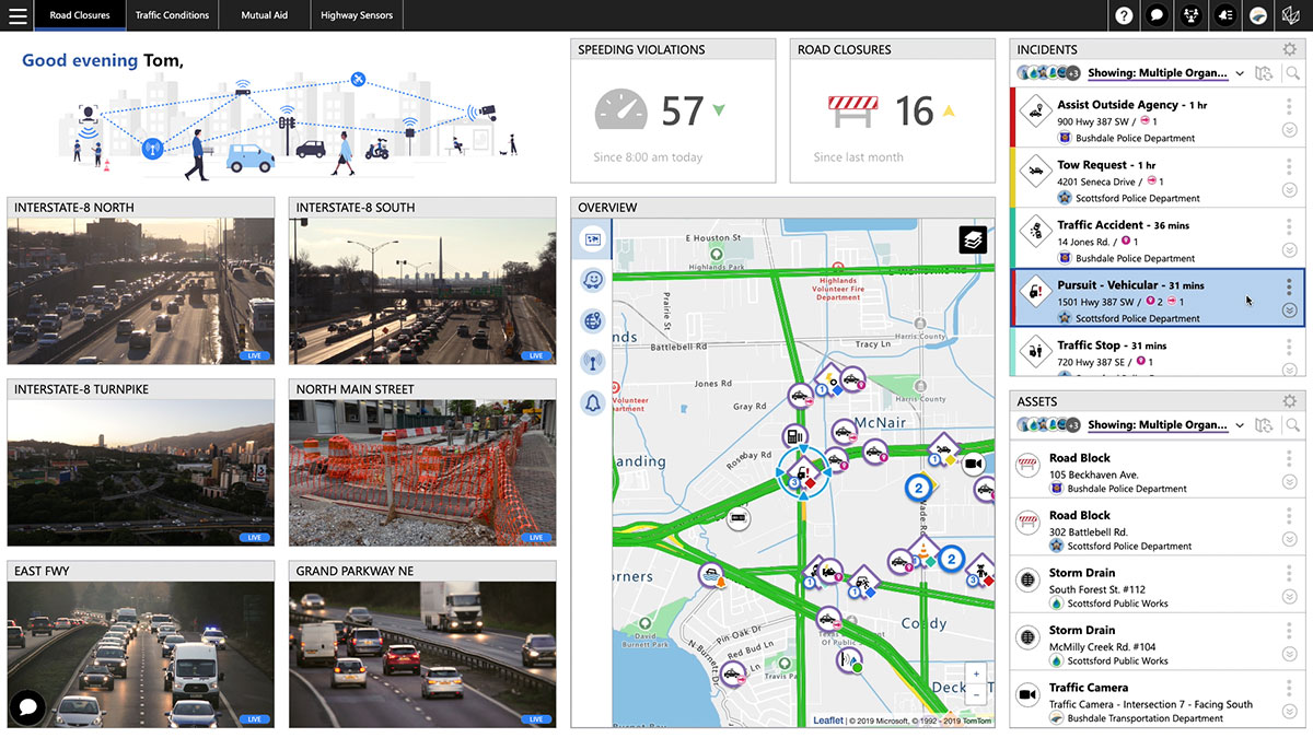
New HxGN Connect enables seamless, citywide collaboration

Hexagon AB has launched HxGN Connect, a software-as-a-service (SaaS) workspace for citywide collaboration enabling government agencies and other organizations to share data and coordinate action for ad-hoc, routine and emergency situations.

Hosted in Microsoft Azure, HxGN Connect provides a networked workspace and unified view of information within and between entities. Participants can actively collaborate and securely share data as events unfold, overcoming technical and political barriers that result in missed opportunities, conflicting actions, errors and delays.

With HxGN Connect, organizations can move beyond basic cooperation to true collaboration, where all participants gain mutual value. HxGN Connect is easily implemented and scaled — whether between multiple departments in a single agency or multiple organizations across cities and regions.

“The future of smart cities lies in connected data communities that enable users to work with people and information irrespective of organisational and geographical affiliations or technology limitations,” said Hexagon President and CEO Ola Rollén. “HxGN Connect reimagines collaboration, breaking down barriers and bridging gaps between vertical sectors, organizational types and operational functions, which means safer cities, more effective services and happier residents.”

HxGN Connect brings a city’s public safety, transportation, utilities and other related organizations together seamlessly. While users can visualize people, places and activities, and send messages and assign tasks to each other, all participants retain full ownership and control of their own data (nothing is stored in a central repository).

The HxGN Connect dashboard. (Screenshot: Hexagon AG)

The HxGN Connect dashboard. (Screenshot: Hexagon AG)

Publicerad den Lämna en kommentar

UAV Navigation autopilot powers Power4Flight engines

UAV Nav logoUAV Navigation’s range of Vector-autopilots is now integrated with Power4Flight’s IntelliJect EFI, designed for use in small-engine aerospace applications.

Using the robust and extensive communication capabilities of UAV Navigation autopilots, the IntelliJect EFI’s engine control unit can communicate and deliver critical parameters through the CAN port. This way, the autopilot is able to automatically control and monitor the engine. The operator will be capable of controlling and receiving real-time status information from the engine in the UAV Navigation’s advanced ground-control station Visionair.

The IntelliJect EFI is highly configurable for a variety of engine types (two-stroke, four-stroke, triples, twins and singles), including Power4Flight’s engines or any other manufacturer engine.

Power4Flight propulsion systems and electronics are used in a wide range of unmanned aircraft systems. With this integration, the fuel injection systems of the American manufacturer will be able to send performance parameters, such as RPM, temperatures, pressures, throttle range and error to the autopilot, and receive commands.

Publicerad den Lämna en kommentar

Commercial UAV Expo Europe delayed to January due to COVID-19

Commercial UAV Expo logoOrganizers of Commercial UAV Expo Europe have announced that the next edition of the event will take place with Amsterdam Drone Week (ADW) and EASA High Level Conference at RAI Amsterdam Convention Center, Jan. 18-20, 2022.

Previously, the events were scheduled to take place together in December 2021, but the organizers have decided — in close consultation with partners Amsterdam Drone Week and EASA — to delay the event until early 2022 due to the impact of COVID-19 on travel and the event industry.

The new date will offer partners, speakers, visitors and delegates more certainty to travel to Amsterdam and thus bring the worldwide UAM/UAS community together. Future editions will revert to the usual December time frame.

“The benefit of co-locating the three events is in bringing the whole drone ecosystem together in one place where professionals can learn, connect and drive the industry forward,” said Lee Corkhill, group event director at Diversified Communications, organizer of Commercial UAV Expo Europe.  “Commercial UAV Expo Europe is the leading international trade show and conference in Europe for the commercial drone market delivering sUAS manufacturers and end-users. Amsterdam Drone Week focuses on Urban Air Mobility and the role of cities. The EASA High Level Conference focuses on the stakeholders involved in UTM and regulatory issues.”

During ADW 2021, the EASA High Level Conference will take place on Jan. 18-19 and the Commercial UAV Expo Europe will be held on Jan. 19-20.

ADW will offer a hybrid option in January 2022, meaning content from the ADW mainstage will be broadcast daily, including matchmaking and online speed networking sessions.

In 2020, ADW organized a successful online event. “Although it was a great success given the circumstances, we prefer to see the fast-growing industry around drones and unmanned aircraft back in Amsterdam in person,” said Paul Riemens, CEO RAI Amsterdam. “Bringing people together is part of the DNA of RAI Amsterdam.”

“Innovative Air Mobility is an area of intense activity for EASA. We are steadily putting all the rules in place for these operations and working on certification for these entirely new types of aircraft,” said EASA Executive Director Patrick Ky. “The High Level Conference at ADW is an important platform for discussions with a range of stakeholders on these developments.”

Commercial UAV Expo Europe, taking place as part of Amsterdam Drone Week along with the EASA High Level Conference, is a leading international trade fair and conference in Europe focusing on the integration and operation of commercial UAS. Industries covered include

  • Construction
  • Drone delivery
  • Energy and utilities
  • Forestry and agriculture
  • Infrastructure and transportation
  • Public safety and emergency services
  • Security
  • Surveying and mapping

The next edition will take place 18-20, 2022 at RAI Amsterdam.

Commercial UAV Expo Europe is presented by Commercial UAV News and organized by Diversified Communications, organizer of Commercial UAV Expo Americas, Geo Week, and Geo Business Show. For information about exhibiting at Commercial UAV Expo contact Katherine Dow, Sales Manager, at kdow@divcom.com or +1.207-842-5497. For attending information, visit www.expouav.com or email info@expouav.com.

EASA High Level Conference

The main theme of the EASA High Level Conference will be “UAM Becoming a Reality.” Main topics are:

  • Multi-Level Governance of Urban Skies
  • Integration of new entrants in Urban Airspace and overall U-space-ATM integration
  • Mobility Hubs: drone and eVTOL landing sites and vertiport.

The outcome of EASA Social Acceptance study and status of the implementation of the key findings will be discussed. There will be presentations and discussions on concrete implementation projects.

In addition, educational and technical sessions, workshops and roundtables will be held on, among others, the application of the guidelines related to design verification of UAS, technical requirements on vertiports, counter drones technology and U-Space implementation.

Amsterdam Drone Week

Amsterdam Drone Week is the global platform for sharing knowledge on current air solutions, potential innovations, and vital regulations. Creating valuable connections with all key players, knowledge institutes and authorities to co-create and cooperate to build the UAM ecosystem. Through live and virtual summits, expert sessions and matchmaking, ADW connects the entire UAM value chain around drone regulations, new technology and future solutions.

Publicerad den Lämna en kommentar

Controversial GAO report on DOD nav webinar June 15

webinar ad

On May 10, the General Accountability Office (GAO) released a report on navigation efforts n the Department of Defense (DOD). Among its findings were that the department regularly fails to establish validated navigation and timing requirements for systems and instead defaults to the capabilities of GPS. Also, that alternate positioning, navigation and timing (PNT) efforts are not prioritized, and sometimes actively opposed, by forces within DOD.

One of the report’s more startling recommendations is that the department change its focus from GPS as the central pillar of its PNT strategy going forward in favor of resilient technologies.

The Institute of Navigation (ION) and Resilient Navigation and Timing Foundation (RNTF) are hosting a webinar to discuss the report with two of its authors on June 15 at 11 a.m. ET. Two members of the Senate Armed Services Committee staff have also been invited as panelists.

After a panel discussion moderated by Dana A. Goward, president of the RNT Foundation, attendees will have the opportunity to ask questions of the panelists.

The event is open to the public, but attendees must register in advance.

Publicerad den Lämna en kommentar

$17M proposed for DOT resilient PNT initiatives

Photo: E4C/E+/Getty Images

Photo: E4C/E+/Getty Images

Office and Management and Budget (OMB) seeks to extend Trump policies and repeal timing law counter to its own study and industry input

The Biden administration’s budget proposal delivered to Congress last week includes $17 million for the small Department of Transportation (DOT) office responsible for leading civil positioning, navigation and timing (PNT) efforts for the nation. This is a marked increase over the $2 million allocated in 2020 and estimated $5 million being spent this fiscal year.

At the same time, it seeks to repeal the National Timing Resilience and Security Act of 2018 that mandated DOT establish a terrestrial timing backup for GPS. This, despite the findings of a recently published RAND study completed for the Department of Homeland Security (DHS), and other input from a telecommunications industry group.

Proposed Spending

The administration’s budget proposes $17 million for the DOT Office of Research and Technology to be split among three areas of effort.

Monitoring and detection. The first is a $3.5 million “(GNSS) performance monitoring and interference detection” project. This is a one-time request that is expected to be followed by a request for $1 million in yearly funding to maintain and operate the capability.

While these may not seem like sufficient funds to many, DOT is tasked with working with other departments and agencies, and to leverage existing capabilities. The National Geospatial-Intelligence Agency (NGA) is specifically named as an important partner with DOT in this effort. NGA already has responsibility for issuing worldwide navigation warnings for U.S. interests. It also has access to a wide variety of information that could be used for the project.

Signal authentication. Another $3.5 million is proposed for Executive Order (EO) 13905 Implementation and GPS Signal Authentication. The EO was issued in February 2020. It seeks to leverage market forces and education to create additional sources of PNT and encourage users to access them. This approach has been criticized by many as unworkable without extensive regulation and mandates for users, while still not addressing the majority of American companies and users.

$1.5 million of this $3.5 million will go to further implement the EO through development of a “PNT threat space model” and otherwise support inter-department PNT profile and research and development efforts.

$2 million would be allocated for a one-time investment in GPS signal authentication to “result in the development and validation of requirements for data and signal authentication capability for civil GPS,” reads the proposal. DOT has regularly requested much greater sums to establish civil signal monitoring, leading many to believe the requirements are already well known. One industry observer suggested this could be “a study in lieu of action.”

GPS Backup. $10 million would be spent for “GPS Backup/Complementary PNT Technologies Research,” essentially follow-on studies to the DOT GPS Backup Technologies Demonstration. “These efforts will further develop PNT modeling, simulation, and testing tools, as well as standards and performance monitoring tools needed to evaluate integration of diverse positioning, navigation, and/or timing technologies into end-user applications. This work will also support development of cyber-secure receivers,” reads the proposal.

Proposed Repeal of Timing Law

More surprising to many than the significant increase in proposed funding is inclusion of a proposal to repeal the National Timing Resilience and Security Act of 2018 (NTRSA).

One congressional staff member expressed shock at seeing that provision. “The act was the epitome of thoughtful, bipartisan congressional effort,” the staff member said. “It was co-sponsored in the Senate by Markey and Cruz, for crying out loud. You can’t get more bipartisan than that. To have this dumped on us without any notice or consultation is amazing. It is not something I would expect from this White House. I am not sure how serious a proposal it is.”

Some observers on the hill and elsewhere have opined that, rather than the repeal proposal being a well-vetted administration policy, it is an effort by OMB staff held over from the previous administration to carry forward and preserve President Turmp’s Executive Order 13905 and other PNT policies. Rather than focusing on establishing a GPS backup capability, they instead urged PNT users to find and pay for alternatives on their own.

Harsh Tone, False Assertions

Compounding the surprise is the exceptionally harsh tone in the proposal, and assertions that many claim are out-right false.
Among the problems with the language seen by observers is its assertion that NTRSA seeks to establish a single backup for GPS services.

“It’s unclear to me where such an assertion is supported in the record,” said Greg Winfree, former Assistant Secretary at DOT in the Obama administration. “NTRSA requires the department to incorporate findings from the GPS back-up demonstration program. That project found a variety of systems are needed to protect America,” he said. “NTRSA does require establishment of at least one system, which is incredibly important. Without at least one alternative in place, GPS is one of highest priority targets for our enemies. We have to get the bullseye off of GPS. NTRSA does that.”

This point on national security was reinforced by Dr. Scott Pace, head of the Space Policy Institute at George Washington University (GWU). Pace was Executive Director for the Space Council in the Trump administration. At a recent GWU webinar on the topic he commented that having an alternative to GPS will contribute to national security and improve global stability. It will “lower the pressure on us to escalate and respond” should GPS satellites be damaged, or services disrupted, he said.
China, Russia, and other nations have terrestrial PNT alternatives to GNSS already in operation. This imbalance creates strategic and tactical problems for the United States according to many analysts.

The proposed budget also describes NTRSA’s goal of providing at least one backup as “…inefficient, anti-competitive, and potentially harmful to the existing market for back-up/complementary PNT services.”

“Exactly the opposite is true,” according to GWU economics professor, Diana Furchtgott-Roth. Until January of this year, she led civil PNT issues within the Trump administration as a Deputy Assistant Secretary for Research and Technology at DOT. “DOT’s Complementary PNT and GPS Backup Technologies Demonstration Report, published in January, specifically stated that a variety of technologies are needed to complement GPS. What is the most cost-efficient in an urban area is not necessarily the most cost-efficient in a rural or maritime area.”

“PNT is a utility used by every American. Having affordable complementary service available to people in rural and urban areas is the height of efficiency. It is unquestionably in the interests of national and economic security. In fact, access to at least one alternative should be free so to encourage adoption and best protect the nation,” she said.

“GPS is now a free service provided by the government, and the government is responsible for making sure that it is reliable. GPS outages would cause harm across a broad range of economic activities, including emergency services, general aviation, pipelines, and the electricity grid,” according to Furchtgott-Roth.

No-So-New and Contradictory Research

The proposal to repeal NTRSA cites “recent federal analyses” as part of its justification. One of these is likely a report done for the Department of Homeland Security (DHS) by the RAND Corporation. Touted in a press release last month as “new research” and labeled “Published 2021,” the work was actually completed in 2019. DHS representatives have said the delay in publication was needed for review and approval.

Yet the report was the basis for a DHS report to Congress submitted in April 2020. This has caused some to opine that its publication was timed to reinforce OMB’s effort to repeal NTRSA. “You don’t submit reports to Congress based on un-reviewed, un-approved material,” said a retired DHS official. “The timing of its release is clearly deliberate.”

The study, “Analyzing a More Resilient National Positioning, Navigation, and Timing Capability,” takes a cost-benefit approach to the issue. One of its high-level findings is that government investment in a duplicate, GPS-like backup capability is not warranted.

At the same time, it found that government investment in a national timing network, such as the one mandated by the NTRSA, is likely warranted. Saying that a complete backup for all GPS services in all parts of the country is not cost-beneficial, the study says there are some “…federal initiatives that do appear to be cost effective or close to cost effective.” These include “Timing-only backup through fiber/FirstNet, eLoran, or STL [Satelles].”

According to the retired DHS official, this directly contradicts OMB’s assertion that NTRSA should be repealed. “Either they didn’t read the whole thing, or they counted on most people not reading farther than the top-level recommendations,” he said. “And those top recommendations were clearly selected to match OMB’s desired outcome.”

Telecommunications Industry Cites Need for NTRSA Provisions

The May 2021 “Report to the President on Communications Resiliency” also runs counter to claims made in the budget proposal. In it the president’s National Security Telecommunications Advisory Committee (coordinated by DHS) cites the need for GPS alternatives in telecommunications and urges President Biden to fund them. It specifically mentions the need for a national timing architecture, and cites the provisions of NTRSA several times as a step in the right direction.

The industry group Alliance for Telecommunications Solutions also sent letters last month to congressional leaders urging funding for GPS alternatives.

Continuing the Discussion

Congress has become increasingly dissatisfied with executive branch actions on resilient PNT over the last decade.

The most recent evidence of this is an extensive and highly critical report of the Department of Defense’s approach to PNT resilience released last month by the Government Accountability Office (GAO). Among its recommendations was to not rely on GPS as a primary PNT source but look to more resilient technologies.

While President Trump’s 2020 Executive Order did not make precisely the same recommendation to civil users, it did focus on “responsible use” of PNT and transitioning to using additional, non-GPS dependent sources.

The question still under discussion is how far the government should go to support such a transition.

Seasoned observers regularly comment that Congress has the “power of the purse” and every President’s budget is “dead on arrival” regardless of which party controls the White House.

It seems clear that resilient PNT will be a topic of lively debate between the Congress and the White House, as well as internally on the hill, for the foreseeable future.

Publicerad den Lämna en kommentar

US Congress may move against Chinese-made drones

The FLIR M440 UAV. (Photo: Teledyne FLIR)

The FLIR M440 UAV. (Photo: Teledyne FLIR)

A bill moving through the U.S. Congress would impose a five-year ban on United States government purchases of drones manufactured or assembled in China, reports The Associated Press. The measure reflects bipartisan concerns that the unmanned aerial vehicles (UAVs) made in China could facilitate Chinese spying on critical infrastructure.

Major commercial and consumer UAV-maker company DJI is based in Shenzhen, China. Many of its small, low-altitude drones are employed by local and regional government users in law enforcement, emergency response and surveying. The ban could affect police departments that rely on federal funds for equipment. In 2020, the Department of Homeland Security halted such grants for Chinese-made drones.

Chinese-made components, including GNSS receivers and inertial sensors, are not addressed in the bill, and the Pentagon has acknowledged that many components for non-Chinese-company drones are made in China.

While the ban wouldn’t go into effect until 2023, many federal agencies have already imposed temporary restrictions on the use of Chinese drones. The Interior Department had flown more than 11,000 drone missions before January, when the agency temporarily grounded its fleet of more than 500 DJI drones over cybersecurity concerns, according to The Hill. The Hill cites a May 6 Pentagon report. The report found no malicious code in the software for DJI’s Government Edition drones.

An analysis by Booz Allen Hamilton released in June 2020 found no evidence that DJI drones have shared sensitive information with the company or the Chinese Communist Party.

In August 2020, the Defense Department issued approval to drones from five companies:

  • Skydio’s X2-D. Skydio is based in Redwood City, California.
  • Parrot’s Anafi USA. While Parrot is based in Paris, France, the ANAFI USA drone is manufactured in the United States for U.S. customers.
  • Teledyne FLIR’s Flir M440 Ion. The drone was originally made by Altavian in Florida, which was acquired by FLIR in December 2020, which was subsequently acquired by Teledyne Technologies in January. Teledyne FLIR is headquartered in Wilsonville, Oregon.
  • Teal Drones’ Golden Eagle. Teal Drones is based in Salt Lake City, Utah.
  • Vantage Robotics’ Vesper. Vantage is based in San Leandro, California.

Publicerad den Lämna en kommentar

TRX Systems delivers NAVWAR threat mapping for foot soldiers

Image: TDK/U.S. Army

Image: TDK/U.S. Army

Electronic Warfare Kit enables dismounted soldiers to detect, map and mitigate the impact of navigational warfare (NAVWAR) attacks

TRX Systems, developer of NEON GPS-denied location solutions, has delivered the TRX Systems Dismount Electronic Warfare (EW) Kit prototype to the U.S. Army.

Developed for U.S. Army Rapid Capabilities and Critical Technologies Office (RCCTO), the TRX EW Kit is designed to extend EW and signal intelligence for the dismounted warfighter.

The kit adds powerful new capabilities to the company’s NEON Personnel Tracker-MIL solution, expanding the integration between its NEON Location Service and ATAK application to better equip dismounted personnel for detection and mapping of jamming and spoofing attacks.

New NEON functionality includes:

  • Robust Interference Detection. Rapidly detects and geo-references NAVWAR threats including GPS jamming, repeating and spoofing.
  • NAVWAR Threat Mapping. Increases situational awareness by geo-referencing and mapping detected threats through integration with ATAK and EW platforms.
  • Reliable Dismount Location Data. Mitigates the impact of NAVWAR attacks by eliminating erroneous GPS inputs while continuing to deliver reliable location data to dismounted users.
  • Integration with NAVWAR Devices. Integrates threat data from Orolia Defense & Security BroadSense Nano and other devices already carried by warfighters to provide a fused NAVWAR threat indication.

The NEON Personnel Tracker Military (PT-MIL) uses a suite of patented algorithms that fuse GNSS, an inertial sensor, ultra-wideband (UWB) and other inputs to deliver reliable position data to dismounted personnel operating in the presence of compromised or intentionally denied GNSS signals.

With the new EW Kit functionality, warfighters will receive real-time situational awareness into jamming or spoofing threats at their immediate location and from other dismount personnel sharing data over the TAK network.

The EW Kit is integrated via soldier plug-ins, enabling threats discovered and mapped by dismounts to be fused into the overall NAVWAR threat picture.

“In today’s conflict zones, it’s becoming increasingly easy for adversaries to launch electronic attacks against GNSS systems using low-cost jammers built with readily available commercial technology,” said Carol Politi, president and CEO of TRX Systems. “The EW Kit developed in the RCCTO program provides dismount soldiers with clear insight into their NAVWAR environment by rapidly detecting and characterizing these NAVWAR attacks, and it mitigates the impact by eliminating compromised data from their position solution.”