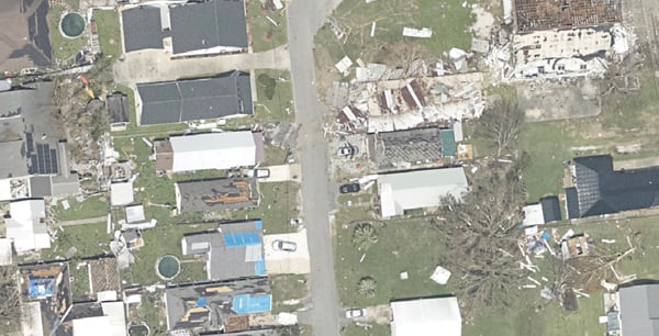
High-resolution imagery geolocated by the sixth-generation Digital Sensor System (DSS) after Hurricane Ida. (Photo: NOAA)
a We discussed this collaboration with Joe Hutton, the company’s director of inertial technology, land and airborne products. Please describe Applanix’s collaboration with NOAA.
Please describe Applanix’s collaboration with NOAA.
We worked with them to develop a solution that allowed them to get out in the field and produce high-accuracy map products with minimal touching of the data. In mid-2021, we delivered the next generation of this solution, or DSS version 6, which represents the culmination of everything learned over the years about how to produce imagery for emergency response, in terms of the types of collection, the types of imagery, and how to get it into first responders’ hands as quickly as possible.
At the heart of the system is our direct georeferencing technology. It’s a solution that allows us to assign the geographic location of every pixel of the digital imagery collected in the air. As soon as you land, you have the coordinates of every pixel, which means you have a map that NOAA then pushes to the cloud for first responders to use in their emergency response efforts.
The collaboration consisted of Applanix working with Lead’Air to manufacture a next-generation system that meets NOAA’s latest requirements. That’s what we delivered in 2021. Weeks after delivery, NOAA was called to respond to several hurricanes. They flew the new system with great success and were able to use it for their response.
What is your perspective on ground control points (GCPs) versus direct georeferencing?
It is impossible to place GCPs in an emergency response when you cannot get on the ground. People who say they need GCPs do not really understand direct georeferencing. The NOAA system does not use GCPs, and the map products are at centimeter-level accuracy.
We use Trimble’s RTX technology, which enables centimeter-level GNSS positioning without base stations, which is important when the CORS or local RTN is unreliable due to a disaster. We have high-accuracy inertial systems that get us the orientation, so that we can go directly to ortho photos and ortho mosaics without running any triangulation or using GCPs in that process. GCPs are only there for quality control.
What are your system’s components?
This system encompasses all the lessons learned over the years in terms of what NOAA needs to optimize both their coastal mapping and their emergency response. It incorporates two pairs of color and near-infrared Phase One cameras configured in an oblique format with some overlap, forming a bowtie footprint on the ground.
You have 100% overlap of the color with the near-infrared, and it’s on a high-performance stabilized mount that keeps everything perfectly level. The mount also has a special feature that enables the operators to rotate the cameras to go into nadir mode, mostly for traditional coastal mapping that requires stereo imagery. We were able to incorporate into a single system the requirements for both emergency response — where you want large coverage and obliqueness to look for damage — and nadir for coastal mapping.