Integritet och cookies: Den här webbplatsen använder cookies. Genom att fortsätta använda den här webbplatsen godkänner du deras användning.
Om du vill veta mer, inklusive hur du kontrollerar cookies, se:
Cookie-policy
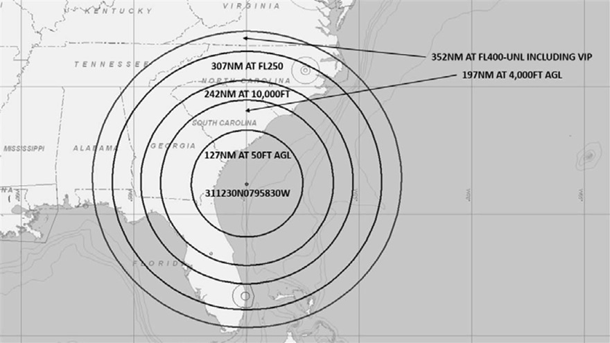
A U.S. Navy exercise in the southeastern United States will involve GPS interference testing that could make aircraft navigation unreliable or unavailable, both today and on Sept. 5.
The Federal Aviation Administration issued an advisory about the testing, which will be centered in the Atlantic off the coast of Savannah, Georgia, on the SAV VOR 139-degree radial at 84 nautical miles.
It could affect GPS reliability — including WAAS, GBAS and ADS-B — centered at 311230N 0795830W (SAV139084):
within a 352-nautical-mile radius at Flight Level 400
within 307 nautical miles at Flight Level 250
within 242 nautical miles at 10,000 feet
within 197 nautical miles at 4,000 feet above ground level
within a 127-nautical-mile radius at 50 feet above ground level.
The tests are scheduled for 1800 Zulu to 2200 Zulu on Aug. 30, and 1600 Zulu to 2000 Zulu on Sept. 5.
The FAA advisory states that GPS interference notices to airmen may change with little or no notice, and encourages pilots to check regularly for updates. NOTAMs will be published at least 24 hours in advance of any GPS tests.
U.S. Space Command Commander General John W. “Jay” Raymond, in his first official directives, established two subordinate commands that will jointly provide support to the new Unified Combatant Command.
Combined Force Space Component Command and Joint Task Force Space Defense will focus the planning and execution of global space operations, activities and missions into two areas:
protection and defense from threats to U.S. space capabilities/forces and
maintaining and growing our national security space programs, combat-relevant space capabilities, and space cadre talent to increase warfighter lethality.
“To ensure USSPACECOM can conduct its mission decisively, I am establishing two subordinate commands with distinct and defined mission areas to ensure the command is postured to protect and defend, while also increasing joint warfighter lethality and strengthening partnerships,” Raymond said.
“The establishment of the Department of Defense’s 11th COCOM dedicated to space operations reflects the value of space contributions to national security, the evolution of the threats to U.S. space systems, and the importance of deterring potential adversaries from challenging or attacking U.S. space systems. These subordinate commands will have a direct impact on that mission,” he said.
JTF-SD
The JTF-SD will be commanded by Brigadier General Thomas L. James, with a mission to conduct space superiority operations in unified action with mission partners to deter aggression, defend space capability and, when directed, defeat adversaries throughout the continuum of conflict.
The JTF-SD will execute its protect and defend mission through various operations centers, including National Space Defense Center at Schriever Air Force Base, Colorado; Space Situational Awareness Units; and Emerging Space Defense Units.
CFSCC
Maj. Gen. Stephen N. Whiting. (Photo: USAF)
The CFSCC will be commanded by Major General Stephen Whiting with a mission to plan, integrate, conduct and assess global space operations in order to deliver combat-relevant space capabilities to Combatant Commanders, Coalition partners, the Joint Force, and the Nation. CFSCC plans and executes space operations through four distinct and geographically dispersed operations centers, including:
Combined Space Operations Center at Vandenberg AFB, California;
Missile Warning Center at Cheyenne Mountain Air Force Station, Colorado;
Joint Overhead Persistent Infrared Center at Buckley AFB, Colorado; and
Joint Navigation Warfare Center located at Kirtland AFB, New Mexico.
Additionally, CFSCC executes tactical control over a number of Air Force, Army and Navy space units.
Protecting critical space assets
“Over the past decade, our great power competitors have developed technologies that threaten our critical national assets in space,” Raymond said. “The U.S. has no desire to see a conflict in space, and we are working hard to ensure no country believes they can gain a terrestrial advantage by extending a conflict to space.
“It’s important to understand that, like all nations, we have the inherent right of self-defense, so purposeful interference with space assets vital to our national security will be met by leveraging our multi-domain capabilities across air, land, sea, cyber and space, and all of our instruments of national power.”
In a move to enhance the United States’ space superiority capabilities, the United States Space Command (USSPACECOM) was formally re-established today.
USSPACECOM existed from 1985 to 2002 but was absorbed into U.S. Strategic Command in 2002 to make room for U.S. Northern Command and a greater focus on homeland defense.
The Department of Defense established U.S. Space Command today as the eleventh Unified Combatant Command, with Air Force General John W. “Jay” Raymond as its congressionally confirmed commander.
From establishment to full operational capability, General Raymond will remain dual-hatted as the commander of Air Force Space Command and U.S. Space Command. The GPS constellation is operated by Air Force Space Command’s 50th Space Wing at Schriever Air Force Base east of Colorado Springs.
USSPACECOM will have a temporary headquarters of about 280 people at Peterson Air Force Base, Colorado.
“Establishing USSPACECOM is a critical step that underscores the importance of the space domain and its strategic contributions to U.S. national security,” the U.S. Space Command stated in a news release. “The USSPACECOM establishment will accelerate the United States’ space capabilities to address rapidly evolving threats to U.S. space assets and the importance of deterring potential adversaries from putting critical U.S. space systems at risk.”
“The scope, scale and complexity of today’s threat is real and it is concerning,” said Raymond during the establishment ceremony. “The establishment of a Combatant Command solely focused on the space domain demonstrates the United States’ commitment to protecting and defending its space assets against that threat.”
Emblem of USSPACECOM
The USSPACECOM mission is to deter aggression and conflict, defend U.S. and allied freedom of action, deliver space combat power for the Joint/Combined force, and develop joint warfighters to advance U.S. and allied interests in, from and through the space domain.
The command will be postured to protect and defend, while increasing joint warfighter lethality by executing two primary missions focused on
unifying and leading space capabilities for the Combined Force, and
maintaining U.S. and Allied advantages in space through protection and defense.
USSPACECOM’s global area of responsibility includes the area surrounding the earth at altitudes equal to or greater than 100 kilometers above mean sea level.
NovAtel, part of Hexagon’s Positioning Intelligence division, now brings users greatly improved processing speed and accuracy as well as significantly reduced signal acquisition time through the latest 7.07.03 firmware release.
The SPAN CPT7. (Photo: NovAtel)
The firmware works best with the recently launched TerraStar-X correction service, which delivers accuracy and reliability, as well as the OEM7, SPAN CPT7 and PwrPak7 products, which use signals from all GNSS constellations and frequencies to provide users with reliable autonomy and exceptional positioning availability.
The 7.07.03 firmware offers a significant improvement to the SPAN GNSS + INS (inertial navigation system) technology. SPAN with 7.07.03 shows improvements of up to 20% in the horizontal position over the entire SPAN IMU catalog and across various industry use cases including agriculture and marine. SPAN with 7.07.03 also provides improved motion detection, resulting in more robust time to convergence.
“The 7.07.03 firmware features improvements to both our SPAN Marine and SPAN Rail profiles that will greatly impact application performance and consistency,” noted NovAtel Director of Product Management, Neil Gerein, “The SPAN Marine Profile sees improvements to the heave performance and will allow users to start their work significantly faster thanks to a simplified setup for applications in marine dynamics. The SPAN Rail Profile improves position accuracy over long GNSS outages, which is crucial for applications in rail environments that often deal with potential signal obstructions such as trees, tunnels and dense urban areas.”
To download the 7.07.03 firmware update for your platform, click here.
3D modeling solution creates true-to-life synthetic environments for more accurate testing.
Spirent Communications plc has launched an innovative multipath simulation solution, Spirent Sim3D. The 3D modeling solution enables the testing of realistic multipath and obscuration effects on GNSS signals in a true-to-life synthetic environment.
Sim3D is suitable for use by automotive, chipset, handset and receiver manufacturers, as well as in aerospace, military, mining and precision agricultural applications.
Spirent will demonstrate Sim3D at ION GNSS+ 2019 in Miami, Florida, Sept. 16-20.
Studying multipath. Historically, researchers and developers of GNSS receivers have had to rely on statistical models and time-consuming field testing to study the effects of multipath on GNSS signals.
With Sim3D, the industry can now gain a greater understanding of the impact of multipath and obscuration in a broad range of real-life situations. It offers the level of control and traceability needed for developers to improve their customers’ experience in the most challenging environments.
A satellite signal reflecting off surfaces, such as a building, a high-sided vehicle, a tree, or even the ground, alters the pseudorange, causing the signal to arrive at the receiver slightly later than line-of-sight signals.
Without proper mitigation, this can cause a receiver to output an inaccurate position.
“Obscuration and multipath effects are one of the major obstacles faced by engineers trying to achieve accurate GNSS positioning solutions,” said Spirent Managing Director of Positioning Martin Foulger. “The accelerating development of connected autonomous vehicles and other precision applications means the need to test for higher precision positioning, navigation and timing in a variety of environments is growing rapidly. Sim3D is an important and timely development.”
Image: Spirent
Simulation of 3D environments. The unique system has been developed in partnership with OKTAL Synthetic Environment. It offers the ability to simulate multipath effects in a range of lifelike geo-typical environments, using different models to recreate locations such as urban highway, an inner city or a forest. Geo-specific models of real locations can also be commissioned.
During simulation with Sim3D, the GNSS signals interact with fully customizable 3D environments to simulate real-life applications in operation, like a vehicle on a highway, or a wearable device on a pedestrian.
This gives a level of detail, control and realism in testing not previously available. Such realistic multipath and obscuration simulation will add greater credibility to GNSS testing and assure that developed solutions are optimized and tested for their intended environments.
“As vehicles become increasingly autonomous, it’s vital to get a more detailed understanding of the effects of obscuration and multipath on a vehicle’s ability to generate an accurate GNSS-based position” explained Foulger. “Statistical models cannot sufficiently achieve this.
“Sim3D’s ability to realistically simulate different environments provides this greater accuracy and brings a host of benefits to researchers and developers of autonomous vehicle systems,” Foulger said. “It will help to guide critical design decisions like where to place the GNSS antenna on the vehicle, what GNSS receiver to use and when to hand over to other position sensors as GNSS signals degrade.”
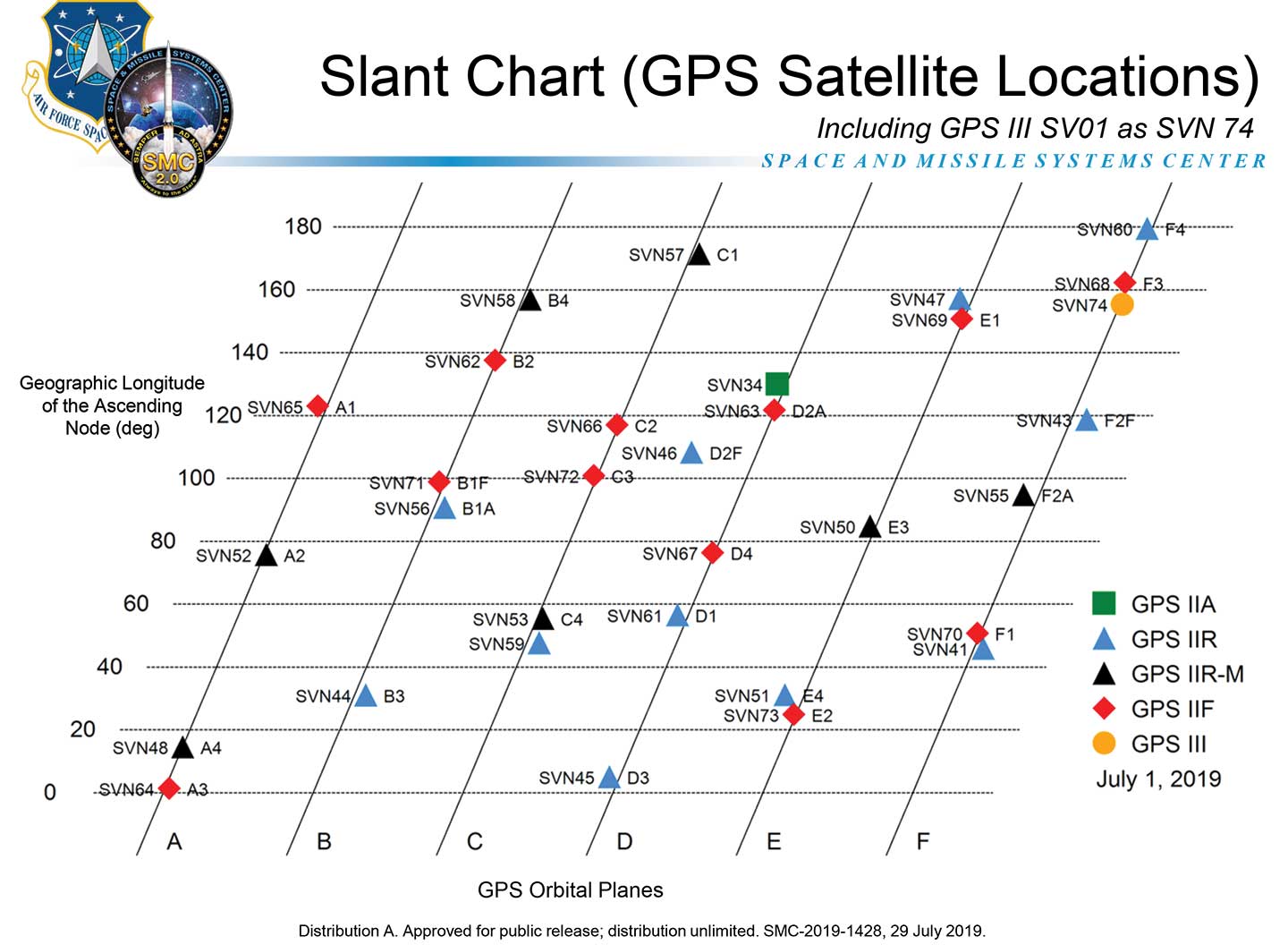
The GPS Directorate has approved a change to the Navstar GPS Control Segment to User Support Community Interfaces ICD-GPS-240 and ICD-GPS-870, reports the U.S. Coast Guard Navigation Center.
The change removes the GPS satellite plane/slot and clock information from the Operational Advisory message. SVN/PRN, block type and NANU details will continue to be included.
The change proposal was approved by the GPS Interface Control Working Group in December 2018.
A depiction of the GPS constellation of satellites with slot and plane designations has been published by the U.S. Coast Guard Navigation Center as an easy-to-read graphic for use by the GPS user community.
Chart: NAVCEN
The chart can be found on the NAVCEN Constellation Status page and will be updated with the commissioning of new GPS satellites or upon any change in the constellation.
Safely integrating autonomous drones into global airspace is the goal of Altitude Angel.
The company has completed its involvement in the Gulf of Finland (GOF) U-Space project, declaring the trials to have been a “huge success” and an “amazing showcase” of its unmanned traffic management (UTM) technologies.
The GOF U-space demonstrations are funded by the SESAR Joint Undertaking for European sky air traffic management research.
In July and August, advanced drone operational demonstrations took place across Estonia and Finland, showcasing use cases that involved both manned and unmanned aircraft in shared airspace. The demonstrations relied on systems such as Altitude Angel’s GuardianUTM O/S to remain safe.
GuardianUTM, the company’s core system, is already helping drones operate in controlled airspace. It powers the UK’s national UTM system, operated by NATS, the UK’s main air navigation service provider.
Photo: Altitude Angel
Altitude Angel was a key UTM partner for the trials, providing services that included integration to the FIMS (flight information management system) for the transport of flight plans, telemetry/position reports, AIM (geofencing/volume reservations), as well as alerts and registration data to-and-from the drone operators and manned aviation which were involved in the trials.
Altitude Angel was able to demonstrate its UTM platform across a number of scenarios that varied in scope and range, and included:
urban drone fleet operations with police intervention,
long-distance multisensory inspection flights over forests,
urban drone operations in controlled airspace,
powerline inspection in rural areas, maritime search and rescue, and
international parcel delivery.
The demonstration series concluded with an urban Volocopter air taxi flight around Vantaa International Airport, Helsinki.
“We’ve been working with the SESAR team for over a year on this project. It’s been a great few months in Finland and Estonia supporting the live demonstrations which have been huge success and an amazing showcase of our world-leading UTM technologies,” said Simon Wynn-Mackenzie, Altitude Angel’s head of products.
“Not only did the scenarios give us another opportunity to demonstrate our production UTM platform in another real-life environment, they went a long way to showing the public how drones can be used in a positive and socially beneficial way on a daily basis,” Wynn-Mackenzie said.
“Our only disappointment was that we were not able to demonstrate our world-first Conflict Resolution Service which we unveiled in July, as the trial scenarios had already been agreed. However, we’ll be looking to showcase our constantly evolving platform and several new services very soon,” he said.
Other UTM demonstrations. In November 2018, Altitude Angel led the team behind Operation Zenith, which gave a view of the future of air traffic management and drone integration into busy, complex airspace, demonstrating how by using the right technology, it’s possible to safely integrate unmanned traffic into controlled airspace and open the skies to commercial airspace worldwide.
The U-space initiative. The GOF U-space project, with a broad consortium of 19 members, demonstrates Europe is on course with its implementation of U-space, an initiative that aims to ensure safe and secure drone traffic management, taking into account the rapid growth in the use of drones.
The GOF concept enables shared situational awareness for all aviation stakeholders. The success of the project is based on deep air traffic management experience of all consortium members, including three world-leading UTM technology vendors and two air navigation services providers, developing interoperability and data-sharing solutions that are aligned with SESAR’s overall U-space architecture.
The U-Space project has received funding from the SESAR Joint Undertaking under the European Union’s Connection Europe Facility (CEF) programme under grant agreement SJU/LC/343-CTR.
u-blox has announced that its Bluetooth low-energy module NINA-B1 has been chosen by AddMobile, Swedish provider of devices and services for construction site management, as the basis of its short-range equipment-tracking beacons, AddTrackers.
Photo: AddMobile
In addition to NINA-B1, the AddMobile Toolbox features the u-blox MAX-M8 GNSS module and the u-blox GSM/GPRS cellular module SARA-G3.
AddTrackers is among the latest enhancements to the company’s AddMobile Toolbox platform and involves adding radio beacons to any tools or equipment that need tracking.
The AddMobile Toolbox helps site managers control mobile work orders, log fleet vehicle mileages, secure entry to work sites, register staff as they come and go, as well as handling fleet management and equipment safety.
It uses a variety of hardware to enable these Connected Construction Site’s services, including stationary hubs and entrance control units with Bluetooth low-energy and cellular connectivity, as well as an RFID reader, and mobile hubs with GNSS, Bluetooth low energy and cellular connectivity.
“The AddTracker beacons and hubs rely upon a combination of GNSS positioning, cellular connectivity, and Bluetooth low energy short-range radio interfaces,” said Bo Lyvall, business development manager at AddMobile. “U-blox was able to provide all three key technologies for our solutions, as well as providing great local support in the Malmö area.”
In use, the beacons equipping tools and equipment communicate with suitably equipped smartphones or other AddMobile hardware infrastructure. When one of these devices picks up an asset’s signal, the asset’s unique ID and GNSS coordinates are sent to AddMobile’s cloud platform, which can then show managers an image of the asset and its position on a map, list the equipment’s features, and show where it is on its planned maintenance schedule.
Trackers don’t have to be static. In one use case, a vehicle is fitted with a mobile hub that includes a GSM connection, GNSS positioning, and a Bluetooth low energy interface in the luggage area.
Tools can be tracked on-site by static hubs, and then followed as they are put into company vans for use offsite. This means that staff scheduling offsite jobs can know the location of all their mobile personnel, and whether they have the right tools with them to undertake each task.
The company was also attracted by the cost efficiency of u-blox’s offering, and what is already a vast installed base of interoperable Bluetooth low energy technology. In the future, the collaboration between AddMobile and u-blox may extend to the use of a longer-range variant of Bluetooth, to further reduce the cost of asset tracking on large and complex sites, and exploring the appropriate use of cellular technology in asset tracking.
CHC Navigation has launched a new website to convey its expanding role as a global leader in geospatial and GNSS products and solutions.
“Our new website provides a clear insight of who we are and where our ambition lies when developing, delivering and supporting high-end, professional and innovative GNSS-based solutions to our customers,” the company stated in a press release. “The website offers extensive refreshed and updated resources presenting the entire scope of CHCNAV solutions to make any surveying work more effective.”
In commenting on the new website, George Zhao, CEO of CHC Navigation said, “We have been enjoying double-digit growth for over 16 years demonstrating the strength of CHC Navigation in the professional GNSS-based markets. Our new website brings a comprehensive vision of our technology and innovation, expanding compelling solutions and our global customer care approach.”
The GPS World staff is reporting live from ION GNSS+ Sept. 16-20 in Miami, providing news, photos, videos and more. According to show organizers, this year’s conference brings together international leaders in GNSS and related positioning, navigation and timing fields to present new research, introduce new technologies, discuss current policy, demonstrate products and exchange ideas.