Publicerad den Lämna en kommentar

Launchpad: GOOSE receiver, splitter and decoder

A roundup of recent products in the GNSS and inertial positioning industry from the October 2019 issue of GPS World magazine.


Multi-GNSS receiver

Refined in the Galileo Online project for rail applications

Photo: TeleOrbit

Photo: TeleOrbit

The multi-GNSS receiver GOOSE, distributed by TeleOrbit GmbH and developed by Fraunhofer IIS, is now available in a new housing. GOOSE now also includes the new OS-NMA beta standard, available by the end of 2019, which was integrated within the research project PRoPART. GOOSE is a flexible, professional GNSS receiver development platform with an open software interface, which can be adapted to a variety of applications and application-specific correction services. The flexible development platform offers multi-system and multi-signal real-time processing; integrated antenna receiver combination (smart antenna); guaranteed stable phase center for all GNSS frequencies; and deployment in commercial PC or as an embedded platform. It allows deep coupling and vector tracking in real time; access to correlation values; and record and replay of IF samples. It also offers access to SBAS data including upcoming augmentation systems and differential augmentation systems. The platform has been refined in the Galileo Online project for specific usage in rail applications. It has also been further upgraded as a robust and reliable Galileo position sensor for autonomous truck applications.

TeleOrbit, teleorbit.eu

Inertial measurement

Low-noise performance for high dynamic applications

Photo: Gladiator Technologies

Photo: Gladiator Technologies

The LandMark 007 inertial measurement unit (IMU) combines low noise, high range sensors and Velox high-speed output in a rugged package measuring 0.7 inches square. With rate ranges up to 2000°/s and acceleration ranges as high as 200 g, the LandMark 007 IMU provides demanding, precision performance for a range of high dynamic, rugged applications. High-speed output data rates (up to 10 kHz) for measurement accuracy and flexibility are complemented by low-noise gyros and accelerometers. A development kit is available.

Gladiator Technologies, gladiatortechnologies.com

Decoder

Corrections data from L6D and l6E

How Allystar's QZSS L6 Decoder TAU1303 operates. (Diagram: Allystar)

Diagram: Allystar

The QZSS L6 decoder module TAU-1303 supports tracking QZSS signals L6D (CLAS) and L6E (MADOCA). It can decode corrections data broadcast from L6D and L6E signals, and assist developers in applying the centimeter-level accuracy by PPP-RTK algorithm with the correction data. Within its 7.6 × 7.6-millimeter size, the module provides six channels to support tracking L6D and L6E at the same time. CLAS on L6D channel corrects satellite clock, orbit, code bias, phase bias ionosphere delay and tropospheric delay. MADOCA on L6E channel corrects satellite clock, orbit, code bias and phase bias. The TAU-1303 offers superior performance through an on-board 26-MHz temperature-compensated crystal oscillator (TCXO) and a reduced time to first fix because of its dedicated 32-KHz real-time clock oscillator. Based on 40-nanometer manufacturing processes of the Cynosure III GNSS chipset, the TAU-1303 has very low power consumption of less than 40 mA at 3.3V.

Allystar Technology Co., www.allystar.com

GPS Splitter

Uses only one rack space

Photo: ViaLite

Photo: ViaLite

ViaLite’s new Local Integrated GPS Splitter was designed to minimize rack space. The unit provides a fan-out of GPS/GNSS signals within a local area, can accept optical inputs from up to four antennas, and has a 1000-1800-MHz frequency range. Though it has a height of only one rack unit, the system is useful for feeding timing and synchronization signals to single or multiple floors or rooms through eight to 32 optical fiber links with no system loss. It includes built-in simple network management protocol (SNMP) control as well as dual-redundant power supply units. Built for data centers, banking institutions, scientific research establishments, cellular test environments, fixed satcom stations, oil and gas platforms, and big data.

ViaLite, vialite.com


Point-cloud software

Creates intelligent 3D mesh models

Image: Pointfuse

Image: Pointfuse

Pointfuse point-cloud processing software converts the millions of individual measurements captured by laser scanning and photogrammetry into 3D mesh models.The latest release features streamlined classification to ensure maximum efficiency and multicore processing for unlimited conversion power. The ability to classify objects and compare as-built objects with the design enables more accurate clash detection, reducing the number of false clashes being flagged. Intelligently optimized mesh models reduce the working data size by a factor of up to 100, making them easy to share with online 3D collaboration platforms, such as BIM 360, 3D Repo, Revitzo and Trimble Connect.

Pointfuse, pointfuse.com

Android Software

Mobile data collection in the field

FieldGenius for Android, v1. (Image: Hexagon)

FieldGenius for Android, v1. (Image: Hexagon)

FieldGenius for Android, version 1.0, is multi-platform data-collection software built on Android OS. The brand-neutral data-collection software supports most popular GNSS sensors on the market. Features include dynamic data panels synchronized with map views, intuitive interface, simplified workflows and readily available data that surveyors require to make informed decisions in the field. Early adopters receive additional benefits and participate in the newly created MicroSurvey Technology Innovation Group.

MicroSurvey Software, microsurvey.com

Handheld GNSS receiver

Camera-enabled centimeter logging

Photo: Spectra Geospatial

Photo: Spectra Geospatial

The SP20 handheld GNSS receiver offers innovative camera-enabled centimeter-accurate logging in an everyday GIS and survey tool. Rugged, lightweight and versatile, the SP20 delivers high-end performance. It is an easy-to-use tool that delivers accuracy from meter to centimeter, depending on the job. Android-based, it is useful for cadastral, construction or topographic surveys; a range of GIS jobs from data collection to inspection and maintenance; and non-traditional geospatial professionals. The 5.3-inch screen displays the new workflow using a camera to ensure 2D centimeter accuracy handheld and 3D centimeter accuracy with monopole setup.

Spectra Geospatial, spectrageospatial.com

Offline data transfer

Alternative to the clouds

Photo: Trimble

Photo: Trimble

TerraFlex users can now synchronize data directly to their on-premise Esri geographic information system without cloud services. The new software workflow — called offline data transfer — is possible through the integration of Trimble TerraFlex and the Trimble Positions Desktop add-in for Esri ArcGIS Desktop. TerraFlex is a field solution that enables mobile workers to easily collect, manage and edit their geospatial feature data. The new workflow provides an alternative to using Trimble cloud services for storing and transferring GIS feature data collected with the TerraFlex platform. In addition, TerraFlex field data collected via this workflow using a Trimble GNSS receiver can be post-processed directly inside the Trimble Positions Desktop add-in for improved positional accuracy. The mobile apps are available in Apple’s App Store and the Google Play store.The Trimble Positions Desktop add-in is available through the Trimble Geospatial distribution channel.

Trimble, www.trimble.com

GPS Receiver

Now compatible with iPhone and iPad 

Photo: Juniper Systems

Photo: Juniper Systems

The Geode GNS2 sub-meter GPS receiver features connectivity with a range of iPhone and iPad devices, made possible by the Geode’s new MFi certification. Features of the Geode GNS2 include an IP-68 rating to withstand harsh environments, all-day battery life, multiple correction sources for precise real-time data, and an open interface that works with a wide range of Windows, Android, iPhone, and iPad devices as well as Juniper Systems’ handhelds.

Juniper Systems, junipersys.com 

Publicerad den Lämna en kommentar

ADVA brings sub-microsecond synchronization to utility and broadcast networks

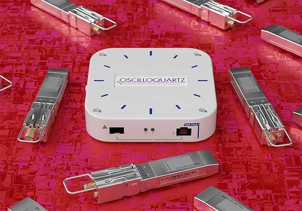
The OSA 5401 and OSA 5405 now enable power utility and broadcast networks to achieve sub-microsecond synchronization. (Photo: Business Wire)

The OSA 5401 and OSA 5405 now enable power utility and broadcast networks to achieve sub-microsecond synchronization. (Photo: Business Wire)

Upgraded PTP grandmaster clocks deliver precise, robust timing in compact form factor

ADVA has extended the capabilities of its compact Oscilloquartz PTP timing technology to enable power utility and broadcast networks to achieve sub-microsecond synchronization.

Now electricity companies can harness the accuracy needed for smart power grids, and media enterprises can meet key timing challenges, the company said.

The two upgraded solutions are the pluggable OSA 5401, a small PTP grandmaster clock, and the versatile OSA 5405, an integrated PTP grandmaster with dual GNSS antenna and receiver.

Both technologies have proved critical in the telecommunications industry, where they have been widely deployed across the globe. They offer outstanding precision and design density. Thanks to unique spoofing and jamming detection capabilities, they also provide high availability.

“This upgrade is big news for utility and media network operators looking to harness the most advanced innovation in their field. With our OSA 5401 and 5405 bringing new levels of accuracy and resilience to their infrastructure, they can reap the benefits of emerging bandwidth-intensive, latency-sensitive applications”

“This upgrade is big news for utility and media network operators looking to harness the most advanced innovation in their field. With our OSA 5401 and 5405 bringing new levels of accuracy and resilience to their infrastructure, they can reap the benefits of emerging bandwidth-intensive, latency-sensitive applications,” said Nir Laufer, senior director, product line management, Oscilloquartz, ADVA.

“These devices are feature rich and incredibly efficient. But as well as their versatility, what really sets them apart is their extremely small footprint and low power consumption. This is key to bringing packet time distribution to the edge of network. With our technology ensuring sub-microsecond synchronization, smart grids can perform flexible, real-time decision making, as well as monitoring and automated maintenance. And for media companies, the possibilities for high-quality, interactive broadcasting from any location are enormous.”

The OSA 5401 and OSA 5405 now comply with the latest PTP profiles for time, frequency and phase synchronization in both power utility and broadcast networks. These include the IEC/IEEE 61850-9-3 Power Utility Profile for precise time distribution and clock synchronization in electrical grids with an accuracy of 1μs, and SMPTE 2059 for synchronizing video and audio equipment over packet networks.

By supporting NTP, both solutions also enable enterprises to run an on-premises NTP server for high levels of accuracy and uncompromised availability. What’s more, the OSA 5401 and OSA 5405 include advanced GNSS jamming and spoofing detection mechanisms, which are integrated in a centralized AI-based GNSS assurance toolkit.

Taking up zero real estate and using very little power, the OSA 5401 can be deployed in the most space-restrictive locations. Its capabilities include multi-constellation GNSS (GPS/GLONASS/BEIDOU) and accurate time and frequency recovery, even in challenging environments such as urban canyons.

Available in both indoor and outdoor variants, the OSA 5405 radically simplifies and extends the reach of GNSS antenna installation by allowing operators to forget about archaic and expensive RF cables and instead use simple Ethernet over copper cables or optical fiber.

With the OSA 5405, highly precise GNSS-sourced synchronization is supported by network-based SyncE and PTP backups for highly stable sub-microsecond timing accuracy.

“Our mission is to make precise, resilient and affordable timing available in every industry. Both our OSA 5401 and OSA 5405 have had a significant impact on communication service provider networks, supporting mass small cell rollout and the transition to 5G connectivity. Now we’re ready to bring accurate, reliable and cost-efficient PTP timing to the edge of power and broadcast networks,” commented Ulrich Kohn, director, technical marketing, ADVA.

“One feature of these devices that will prove key to network operators in these industries is their unique spoofing and jamming detection capabilities. These work on two layers. Firstly, network elements identify disruption autonomously. Then, on top of that, a layer powered by AI analyzes information from multiple devices. Using machine learning, this delivers the highly sophisticated and extremely robust protection needed for machine type communication applications in energy grid protection and control,” Kohn said.

Further information can be found in these slides.

A supporting solution brief is also available.

Publicerad den Lämna en kommentar

Flowfinity and Leica Geosystems streamline high-precision GNSS data collection workflows

Photo: Leica Geosystems

Photo: Leica Geosystems

Flowfinity Wireless Inc. has today released new functionality that allows field users to collect highly precise GNSS location data via external Leica Zeno GG04 plus Smart Antennas in Flowfinity applications.

This powerful new capability assists organizations in the engineering, environmental consulting, construction and public utilities sectors that use custom mobile data collection apps built with Flowfinity to survey and inspect work sites.

The Zeno GG04 plus is a rugged, flexible and easy-to-use smart antenna from Leica Geosystems, part of Hexagon. It uses RTK technology and Precise Point Positioning (PPP) to make high-accuracy data collection possible in real-time even in demanding locations without the need for a mobile data connection.

Photo: Flowfinity

Photo: Flowfinity

The combination of state-of-the-art Zeno GNSS technology with the workflow automation features in Flowfinity Actions is a game-changing update that will save hours in the field while providing location data accurate to five decimal places for analysis in the office.

“This is an exciting update for any organization that needs to record accurate site survey data as part of their digital mobile workflows,” said Larry Wilson, VP Sales & Marketing, Flowfinity. “Field users in engineering and related industries can now collect some of the most precise GNSS readings possible and have that info available in their existing Flowfinity applications. This opens up significant opportunities to become more efficient on-site.”

All Flowfinity applications deployed on Android and iOS devices can now leverage the Leica Geosystems antenna to achieve 5 decimal place accuracy for GNSS location data.

For example, if an environmental consulting firm needs survey quality GNSS data to be collected and submitted during site inspections, they can now deploy field workers with Leica GG04 plus Smart Antennas to record data directly into their Flowfinity mobile applications, rather than performing manual data entry or relying on much less precise data from internal mobile device sensors.

Flowfinity is used across industries including environmental services, engineering, construction, municipal governments and utilities for driving efficiency and streamlining operational workflows.

Go here for complete list of new features.

Publicerad den Lämna en kommentar

3GPP approves NaVIC for global commercial use

Disy Informationssysteme GmbH, www.gis2go.com

Photo: Gis2Go

Global mobile wireless standards body 3GPP has given its approval to the regional navigation system created by the Indian Space Research Organisation (ISRO), known as NaVIC, reports The Times of India.

The approval was given for the system’s use in Rel-16 LTE and Rel-17 5G NR specifications, paving the way for wider commercial adoption of NaVIC and allowing it to be integrated with 4G, 5G and internet of things technology (IoT).

Once these specifications are adopted by Telecommunications Standards Development Society, India (TSDSI), IoT devices in India can make a switch from GPS to NaVIC.

Electronics companies can start designing and building integrated circuits and mass manufacture other products created to be compatible with NaVIC.

Publicerad den Lämna en kommentar

Future UK GNSS gets small business investment

logoWith Brexit on the horizon, the UK Space Agency is interested in creating its own GNSS.

The agency is investing in research and development that explores challenges and ideas around receivers for a future UK global navigation satellite system.

Specifically, the agency is seeking UK organizations that are interested in investigating and developing concepts for satellite system receivers.

The best ideas could be awarded contracts in a later stage of the competition under the Small Business Research Initiative (SBRI).

Following Brexit, the UK would be locked out from the European Union’s Galileo-provided services, including the upcoming Public Regulated Service (PRS), an encrypted navigation signal for governmental-authorized users and sensitive applications such as the military.

Publicerad den Lämna en kommentar

MBDA investigates GPS/GNSS-denied navigation under REASON project

The REASON project uses satcom signals to help long-range missiles navigate. (Image: MBDA)

The REASON project uses satcom signals to help long-range missiles navigate. (Image: MBDA)

MBDA Missile Systems is exploring a navigation solution for long-range cruise missile systems that would use satellite communications signals to maintain precision navigation accuracies at range, reports Jane’s 360.

MBDA told Jane’s that is has demonstrated for the first time a satcom-aided navigation as part of the Resilient and Autonomous Satcom Navigation (REASON) project. Also taking part in the project are Airbus Defence and Space and ONERA.

REASON is part of the UK/French Materials and Components for Missiles Innovation and Technology Partnership (MCM IPT) programme, for which MBDA is the lead.

REASON is evaluating the technical and system-level feasibility and benefits of using specialist satellite signals to aid navigation.

For a medium-to-long duration flight, cruise missile systems require additional information to support inertial measurement unit (IMU) sensors to achieve the required level of guidance accuracy, Jane’s reported. Recent years have seen greater reliance on GPS/GNSS signals to provide navigation updates to correct IMU drift.

Publicerad den Lämna en kommentar

Polte and Altair embed location services on cellular IoT chipset

Altair Semiconductor integrates Polte’s Cloud Location over Cellular (C-LoC) technology with Altair’s ALT1250 dual-mode CAT-M& NB-IoT chipset.

Photo: Altair

Photo: Altair

Polte Corp. and Altair Semiconductor have collaborated to integrate Polte’s cellular-based location technology with Altair’s ALT1250 cellular Internet of Things (IoT) chipset.

The ALT1250 is Altair’s dual-mode CAT-M & NB-IoT solution, a small, highly integrated cellular IoT chipset with ultra-low power consumption, GNSS location positioning, a hardware-based security framework and an RF front-end supporting all commercial LTE bands.

Enabling miniature module sizes of less than 100 square millimeters, the ALT1250 is suitable for a range of industrial and commercial IoT applications.

Polte’s patented location-as-a-service (LaaS) solution leverages ubiquitous 4G and 5G cellular networks and cloud computing to enable highly accurate location data indoors and outdoors.

Business processes, customer self-service automation, and better decision making insights enable consumer, commercial and industrial businesses to capitalize on location.

“With the explosive demand for smaller and low powered IoT devices, Polte’s C-LoC technology is a great complement to the integrated GPS and GNSS capabilities of our dual-mode ALT1250 chipset,” said Oded Melamed, CEO of Altair Semiconductor.

“Location is a key function in numerous IoT applications, such as smart meters, telematics and trackers, where low power and small form factor are crucial,” Melamed said. “We look forward to the opportunity of working with Polte to offer our customers the best solutions to meet their needs.”

“Polte is poised to disrupt the location services market. As more and more IoT use cases demand indoor, outdoor and everywhere in between location, Polte’s software-only solution embedded on Altair’s dual mode ALT1250 chipset delivers location services — at lower cost, using less battery, more securely,” said Polte CEO Ed Chao. “We are excited about the opportunity to bring the power of Polte’s location services platform to Altair’s leading Cellular IoT chipset.”

Publicerad den Lämna en kommentar

Business presidents named for consolidated Raytheon businesses in Raytheon/United Technologies merger

logosRaytheon Company Chairman and CEO Thomas A. Kennedy today announced leadership appointments for the Raytheon businesses that will be consolidated following the close of the merger of equals with United Technologies.

Roy Azevedo will be president of the Intelligence, Space and Airborne Systems, which combines Space and Airborne Systems (SAS); Intelligence, Information and Services (IIS); and Forcepoint. The new business unit will have 2019 sales of approximately $15 billion.

Wesley D. Kremer will be president of the Integrated Defense and Missile Systems, which combines Missile Systems (MS) and Integrated Defense Systems (IDS). The new business unit will have 2019 sales of approximately $16 billion.

“Roy and Wes are defense industry veterans with proven track records developing and delivering advanced technologies,” said Thomas A. Kennedy. “Their global business acumen and strong customer focus will help ensure the new Raytheon Technologies Corporation is poised for success from day one.”

Anthony “Toby” O’Brien was selected as chief financial officer for the new Raytheon Technologies Corp. O’Brien is the current CFO of Raytheon Company.

The Raytheon business unit consolidation will be effective upon merger close, which is expected in the first half of 2020, subject to the satisfaction of customary closing conditions, including receipt of required regulatory approvals, as well as completion by United Technologies of the separation of its Otis and Carrier businesses.


Roy Azevedo, President, Intelligence, Space and Airborne Systems

Roy Azevedo was appointed president of Raytheon SAS in 2018. The business is a leader in the design, development and manufacture of integrated sensor and communication systems for advanced missions. These missions include intelligence, surveillance and reconnaissance; precision engagement; manned and unmanned aerial operations; electronic warfare; and space.

With a workforce of 17,600 and 2018 sales of $6.7 billion, Space and Airborne Systems is headquartered in McKinney, Texas and operates across the United States and internationally, overseeing Raytheon UK.

Before being named president of SAS, Azevedo was vice president and general manager of Raytheon’s Intelligence, Surveillance and Reconnaissance Systems, a mission area within SAS that focuses on electro-optical/infrared sensors, active electronically scanned array/scanning radars, and various special mission aircraft solutions to provide customers with actionable information for strike and persistent surveillance.

The new Intelligence, Space and Airborne Systems business which Azevedo will lead, pairs his existing business unit with Raytheon’s Intelligence, Information and Services business, and the company’s commercial cybersecurity unit, Forcepoint™. The newly combined business will offer world-class airborne and space sensors, electronic warfare and communications systems, cybersecurity and cyber analytics capabilities, advanced air traffic control technologies, ground-based space logistics, training, and engineering services. It will also provide artificial intelligence and machine learning capabilities, and mission support.

Azevedo, who joined Raytheon in 1989, also serves as a member of the Raytheon Saudi Arabia, Raytheon UK and Raytheon Australia Boards of Directors.


Wesley D. Kremer, President, Integrated Defense and Missile Systems

Wes Kremer currently serves as president of Raytheon Missile Systems, after being appointed to the role in March 2019. Missile Systems is the world’s leading producer of weapon systems for the United States military and the allied forces of more than 50 countries. It produces defensive and offensive weapons for air, land, sea and space, including interceptors for U.S. ballistic missile defense. The business continually develops and invests in new, innovative technologies such as hypersonic and counter-hypersonic weapons and directed energy systems to provide rapid, high-quality, affordable mission capability to its customers. It had 2018 sales of $8.3 billion and employs more than 16,000 people. Headquartered in Tucson, Arizona, Missile Systems also has locations in Alabama, Arkansas, Kentucky, New Mexico, Oklahoma and Texas, as well as oversight of Raytheon Emirates, where Kremer serves as board chair.

Prior to leading MS, Kremer was president of Raytheon’s Integrated Defense Systems business, which is headquartered in Tewksbury, Massachusetts with 31 locations around the world and operational oversight of Raytheon Saudi Arabia. Its broad portfolio of weapons, sensors and integration systems supports its customer base across multiple mission areas, including air and missile defense systems; missile defense radars; early warning radars; naval ship radar systems; C5I® products and services; and other advanced technologies.

Kremer also served 11 years in the U.S. Air Force as a weapon systems officer, flying the F-111 and F-15E, with more than 1,500 hours of flight time in fighter aircraft, including over 90 combat sorties. He joined Raytheon in 2003.


Anthony “Toby” O’Brien, Chief Financial Officer

Toby O’Brien was named chief financial officer for the future Raytheon Technologies Corporation on September 12, 2019. He currently serves as vice president and chief financial officer of Raytheon Company where he directs the company’s overall financial strategy. His responsibilities include financial reporting and controls, merger and acquisition activity, planning and analysis, investor relations, tax and treasury.

Prior to his current position, O’Brien was vice president of finance and chief financial officer for Raytheon IDS. He has also served as Raytheon vice president of finance, CFO of Raytheon Aircraft Company and has held other senior finance positions across Raytheon.

O’Brien joined Raytheon in 1986.

Publicerad den Lämna en kommentar

Apple warns old iPhones, iPads could hit GPS rollover problem

iPhone 4s. (Photo: Apple)

iPhone 4s. (Photo: Apple)

Anyone who owns an older model Apple iPhone or iPad could experience a device-breaking problem on Nov. 3, according to Apple.

The issue could affect iPhone and iPad models introduced in 2012 and earlier.

“If you don’t update to the newest version of iOS available for your device before November 3, some models might not be able to maintain an accurate GPS position. And functions that rely on the correct date and time—such as syncing with iCloud and fetching email—might not work,” Apple said in a blog post.

The problem is because of the GPS time rollover on April 6. Affected Apple devices won’t be impacted until just before 12 a.m. UTC on Nov 3.

The iOS update will solve the problem, enabling the device to maintain accurate GPS location and keep the correct date and time.

Devices affected include iPhone 4s and 5, third and fourth-generation iPad, iPad mini and iPad 2. Learn specifics of affected models and how to update the operating system on the Apple website.

If not updated, these devices might not be able to maintain accurate GPS position or perform functions that require accurate time, such as properly syncing with iCloud or fetching email. The devices also might not be able to receive over-the-air software updates. As a result, the only way to update the device will be to restore it via iTunes or Finder through a tethered connection.

Publicerad den Lämna en kommentar

First Fix: Regulation is necessary to advance drone operations

Experts discuss GNSS/PNT news, trends, obstacles and opportunities

Guest column by Brian Wynne
AUVSI President and CEO

Brian Wynne, AUVSI president and CEO

Brian Wynne, AUVSI president and CEO

A recent analysis found that just 10 percent of the unmanned aircraft systems (UAS) included in the Unmanned Systems and Robotics Database maintained by the Association for Unmanned Vehicle Systems International (AUVSI) can operate beyond the visual line of sight (BVLOS) of its operator.

While the technology for BVLOS operations has existed for years, under current federal regulations, only the military is permitted to use it. The absence of federal regulation allowing BVLOS operations hinders the full value and benefits that the UAS industry has to offer.

Regulations that provide guidance and rules for operating unmanned systems are necessary for the industry’s advancement. Earlier this year, the Federal Aviation Administration (FAA) issued a proposed rule for UAS operations over people, and the UAS community is eagerly anticipating the agency will offer an additional rule requiring UAS to be equipped with remote identification.


“Remote ID is a crucial next step to gain the confidence of federal defense and security agencies, manned aviation users and the public.”


However, the rulemaking process for remote ID has been delayed by the FAA twice this year and is now slated to be released in December. The need for remote ID cannot be overstated, as the advancement of the UAS industry depends on identifying and tracking UAS flying in the airspace.

Furthermore, remote ID is a crucial next step to gain the confidence of federal defense and security agencies, manned aviation users and the public. With this confidence, UAS can further integrate into the national airspace to perform important BVLOS operations such as inspection of utility rights of way, widespread search-and-rescue missions, and package delivery.

A clear, national regulatory framework and the support of the federal government is needed to drive the adoption of unmanned systems technology and its applications. Currently, the UAS industry is working with our government partners on remote ID and tracking standards, but we recognize that more needs to be done and at a faster pace than the regulatory process allows. That is why the UAS industry is stepping up to explore near-term solutions before remote ID regulations are finalized and published.

In May, AUVSI and the Airports Council International-North America commissioned a Blue Ribbon Task Force on UAS Mitigation at Airports. The task force is working to refine procedural practices and provide a policy framework to address the timely and critical issue of incursions by unauthorized UAS at airports and how best to mitigate this threat, including industry and government recommendations for remote ID. The task force will release a report this year.

Applications of unmanned systems aren’t limited by technology or imagination; they’re only limited by regulations. We need a streamlined regulatory environment that allows for the safe deployment of unmanned systems into our nation’s transportation infrastructure so we can begin to reap the full benefits of this technology.