Publicerad den Lämna en kommentar

Wingcopter contracted for US medical deliveries

Photo: Wingcopter

Photo: Wingcopter

German drone-delivery company Wingcopter has signed a commercial agreement with Spright worth US$16 million to enable UAV medical deliveries.

Spright is a subsidiary of American air medical service provider Air Methods. Under the agreement, Spright is acquiring a fleet of Wingcopter’s flagship delivery drone, the Wingcopter 198, to meet the increasing demand for medical drone deliveries throughout the United States.

The contract makes Wingcopter the exclusive provider of fixed-wing electric vertical take-off and landing (eVTOL) delivery-drone technology to Spright. Spright, in turn, becomes exclusive provider of maintenance, repair and overhaul for the Wingcopter 198 to third parties in the United States.

Drone Division Launched

Spright was launched in July 2020 as the new drone division of Air Methods to improve healthcare access and minimize supply challenges for customers across the United States. To this end, Spright is creating a drone-based, U.S. healthcare-specific delivery network leveraging an existing infrastructure of more than 300 bases, serving hundreds of hospitals across 48 states in predominantly rural areas.

The agreement further strengthens the strategic partnership between the two companies, announced in August 2021. Spright is closely supporting Wingcopter in its Federal Aviation Administration (FAA) UAS type-certification process, leveraging Spright’s aviation experience operating FAA 121 and 135 air carriers, its existing Part 135 certificate (on-demand air service) and safety management system program.

Spright is collaborating with Hutchinson Regional Health System in Hutchinson, Kansas, for initial tests, and plans to expand the service beyond Kansas with additional strategic medical projects later this year.

The Wingcopter fleet will increase healthcare access across rural and underserved communities by enabling instant and on-demand delivery of vital medical supplies, medications, vaccines, blood and lab samples between medical facilities. It will also improve quality of care for patients with faster turn-around time of lab samples and more targeted treatments for patients.

Finally, the electrically powered Wingcopter cargo drones will reduce the medical industry’s carbon footprint, contributing to greener and more sustainable supply chains with faster and more predictable delivery times.

Wingcopter and Spright will showcase the Wingcopter 198 delivery drone and provide an opportunity to meet executives of both companies at the logistics tech conference Manifest in Las Vegas Jan. 25-27.

Publicerad den Lämna en kommentar

U-blox adds LENA-R8 GNSS receiver to LTE Cat 1 portfolio

Photo: U-blox

Photo: U-blox

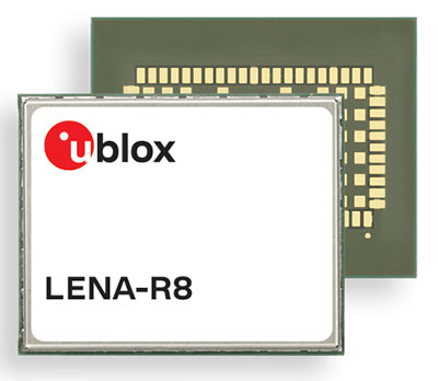
U‑blox has added a GNSS receiver module to its cellular LTE Cat 1 portfolio. The GNSS receiver in the LENA-R8 is based on the u‑blox M10 platform.

U-blox also introduced the LARA-R6, its smallest LTE Cat 1 module with global coverage. Together, the modules comprise five certified global, multi-regional and regional product variants, simplifying logistics for product developers and increasing design flexibility.

Both modules offer device makers facing imminent 2G and 3G network sunsets a future-proof migration path to 4G technology for data-streaming applications.

Additionally, they offer MQTT Anywhere and MQTT Flex connectivity via u‑blox’s Thingstream platform out of the box, thereby enabling low-power, low-cost connectivity with globally ubiquitous, seamless roaming.

Tracking and Telematics

The LENA-R8 standard-grade module series targets customers in the tracking and telematics markets seeking to minimize costs associated to their bill of material and data charges. The compact module balances cost and performance with single Rx antenna and primarily targets customer deployments in the Europe, Middle East, Africa, Asia, and South America regions.

The LENA-R8 supports a broad range of frequency bands with 2G fallback, providing maximum roaming coverage for global tracking applications using a single stock keeping unit (SKU).

A variant of the LENA-R8 series comes with an ultra-low power u‑blox M10 GNSS receiver for high performance asset tracking applications, reducing integration effort and time to market. Making no compromises in terms of GNSS performance, the module can concurrently receive up to four GNSS constellations for maximum position availability.

CellLocate Support

All variants of the LARA-R6 and LENA-R8 family support CellLocate, u‑blox’s cellular network-based location service, for coarse positioning data even in the absence of GNSS signals.

Engineering samples will be available in February.

Publicerad den Lämna en kommentar

Space Systems Command launches USSF-8 mission for US Space Force

Space Systems Command, together with United Launch Alliance and other mission partners, successfully placed the fifth and sixth Northrop Grumman-built Geosynchronous Space Situational Awareness Program (GSSAP)-5/-6 satellites into orbit for the U.S. Space Force, after an on-time launch aboard an Atlas V rocket from Space Launch Complex (SLC)-41 at Cape Canaveral Space Force Station, Florida, at 2 p.m. EST (11 a.m. PST).

“The evolving threat to our space environment requires new levels of resiliency and survivability, autonomy and automation, and unprecedented levels of integration and networking,” said Lt. Gen. Michael A. Guetlein, commander of Space Systems Command. “Today’s successful launch will enhance our capabilities in space domain awareness and our space-based space domain awareness architecture. Congratulations to the USSF-8 integrated team and all mission partners on a successful launch.”

The GSSAP-5/-6 satellites join a constellation supporting U.S. Space Command’s space surveillance operations as a dedicated Space Surveillance Network sensor.

GSSAP also supports the Combined Force Space Component Command by collecting space domain awareness data, allowing for more accurate tracking and characterization of manmade orbiting objects. GSSAP is led by SSC’s Special Programs directorate.

The National Security Space Launch (NSSL) mission launched aboard ULA’s Atlas V in the “511” configuration, which was comprised of a five-meter diameter payload fairing from RUAG Space, a single Graphite Epoxy Motor (GEM)-63 solid rocket booster from Northrop Grumman, and a single RL-10 engine from Aerojet Rocketdyne on the Centaur upper stage.

SSC’s Launch Enterprise acquired the launch service through ULA and was responsible for successfully placing the GSSAP satellites on orbit.

The NSSL program provides assured access for the United States’s critical warfighting space assets, and this launch vehicle has reliably placed valuable assets into their intended orbits repeatedly, adding to the NSSL program’s success record of 88 consecutive launches. The program supports a full range of government mission requirements for the nation’s defense and intelligence sectors.

Space Systems Command is the U.S. Space Force field command responsible for rapidly identifying, prototyping and fielding resilient space capabilities for joint warfighters. SSC delivers sustainable joint space warfighting capabilities to defend the nation and its allies while disrupting adversaries in the contested space domain. SSC mission areas include launch acquisition and operations; space domain awareness; positioning, navigation and timing; missile warning; satellite communication; and cross-mission ground, command and control and data.

A ULA Atlas V rocket carried the USSF-8 mission for the U.S. Space Force into orbit, (Photo: ULA)

A ULA Atlas V rocket carried the USSF-8 mission for the U.S. Space Force into orbit, (Photo: ULA)

Publicerad den Lämna en kommentar

European GNSS RTK network upgraded with Tallysman antennas

Photo: Tallysman

Photo: Tallysman

Case New Holland (CNH) has selected the Tallysman Wireless VeraChoke antenna for modernization of its high-precision European GNSS real-time kinematic (RTK) network.

“The objective of the GNSS antenna update is to enable the tracking of all GNSS constellations and signals, thus improving the robustness, convergence time, and accuracy of positioning within CNH’s European RTK network,” said Michiel Jochims, CNH Industrial RTK manager EMEA. “At this stage, with only 25 stations updated, we are delighted to observe a significant performance improvement. We look forward to continuing the network update and bringing enhanced positioning to all of our European customers.”

The VeraChoke antenna provides excellent multipath suppression and repeatability of PCV and group delay variation (GDV), making it suitable for GNSS reference networks, explained Temo Wubbena, CEO of Geo++. “After detailed analysis, we have recommended Tallysman’s VeraChoke antenna to CNH Industrial.” Geo++ is supporting the upgrade of CNH Industrial’s European RTK network.

The patented VeraChoke has a very tight phase center variation (PCV), strong multipath mitigation and excellent performance across the full GNSS spectrum. Its PCV and phase center offsets (PCOs) are repeatable from unit to unit, making suitable for network RTK applications.

Publicerad den Lämna en kommentar

GPS satellite SVN-47 decommissioned, SVN-41 returns to broadcast almanac

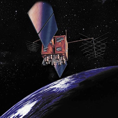
Artist's rendition of a GPS-IIR satellite in orbit. (Image: GPS.gov)

Artist’s rendition of a GPS-IIR satellite in orbit. (Image: GPS.gov)

The U.S. Space Force has announced the decommissioning of GPS satellite SVN-47 (PRN-22), which officially took place Jan. 18.  The satellite has been unusable since Dec. 2.

SVN-47 was a replacement satellite in the second generation of GPS satellites (GPS-IIR), launched Dec. 21, 2003.

The announcement was made in a Notice Advisory to NavStar Users (NANU 2022001) issued by NAVCEN, U.S. Coast Guard.

The designation PRN-22 will be used to bring SVN-41 back in to the active constellation. After 2200 Zulu on Jan. 2o, GPS will transition SVN-41 (PRN-22) into the broadcast almanac for all satellites, and SVN-41 will resume transmitting L-band signals. The almanac transition, accomplished one satellite at a time, will require approximately 24 hours to complete.

A second NANU emphasized that “Before, during, and after transition SVN-41 (PRN22) will remain unusable until further notice.”

SVN-41, the sixth of the GPS-IIR satellites, was launched on Nov. 10, 2000, and set to active service a month later on Dec. 10. It was decommissioned in July 2021.

Publicerad den Lämna en kommentar

Launchpad: Timing antennas, defense UAS, infrastructure mapping

A roundup of recent products in the GNSS and inertial positioning industry from the January 2022 issue of GPS World magazine.


Surveying

Base Station

Receives all available GNSS signals

Photo: Trimble

Photo: Trimble

The Trimble R750 GNSS modular receiver is a connected base station for use in civil construction, geospatial and agricultural applications. The R750 provides high-accuracy base-station performance, giving contractors, surveyors and farmers more reliable and precise positioning in the field. The R750 also can be used to broadcast real-time kinematic (RTK) corrections for a wide range of applications, including seismic surveying, monitoring, civil construction, precision agriculture and more. Access to all available satellite signals provides improved performance and reliability when used with a Trimble ProPoint GNSS rover. ProPoint gives users improved performance in challenging GNSS conditions, with improved signal management.
Trimble, trimble.com

Flight Planning

Updated for safer UAV surveying

Photo: mdCockpit

Photo: Microdrones

The mdCockpit app was designed for professional drone users to make it easy to plan, monitor, change and control flights from an Android tablet. The updates in version 2021.3 include features that improve flight safety and give more options for surveying with an aim to deliver a premier solution for planning, monitoring, adjusting, analyzing and controlling professional drone flight missions from a tablet. Updates include an improved flight editor, flight data collection and drone configuration. Drone pilots can download mdCockpit through the Google Play store.
Microdrones, microdrones.com


OEM

LTE Module

With 2G fallback for Latin America

Photo: Telit

Photo: Telit

The LE910S1-ELG LTE Cat 1 module is designed for internet of things (IoT) applications in Latin America that need a combination of performance, affordability and voice support in a compact form factor. It provides 2G fallback, making it suitable for areas that have not upgraded to 4G. With an embedded GNSS receiver, the cost-optimized LE910S1-ELG is suitable for tracking applications such as fleet management, stolen-vehicle tracking and recovery, and other mobile IoT applications that need to maintain a reliable connection when moving around in a country, region or multiple regions. The power-saving embedded GNSS receiver enables the use of GNSS positioning even when the cellular modem is switched off.
Telit, telit.com

Flex Power

Capability now on constellation simulator

Photo: Spirent

Photo: Spirent

A new positioning, navigation and timing (PNT) test capability commonly referred to as programmable power — or flex power — is available on the Spirent GSS9000 constellation simulator and can be applied to existing scenarios. Flex power is the reallocation of transmit power among individual signals in GPS satellites, providing a countermeasure against GPS jamming. Spirent simulators fully support programmable power for M-code, Y-code and C/A (coarse acquisition) code.
Spirent, spirent.com

GNSS Module

Automotive qualified with INS and dead reckoning

Photo:

Photo:

The Teseo-VIC3DA is the latest member of the Teseo module family, designed for vehicle positioning. It combines the Teseo III GNSS integrated circuit with the 6-axis MEMS inertial measurement unit (IMU) and dead-reckoning software to provide super-high-resolution motion tracking for advanced vehicle navigation and telematics applications. Teseo III offers robust positioning capabilities by simultaneously receiving signals from GPS, Galileo, GLONASS, BeiDou and QZSS constellations. The module enables competitively priced in-car navigation, fleet management and insurance-monitoring applications.
STMicroelectronics, st.com

PNT Platform

Protects critical infrastructure from GNSS vulnerabilities

Photo: ADVA

Photo: ADVA

The scalable aPNT+ platform meets the latest guidelines for resilient positioning, navigation and timing (PNT), providing end-to-end control and timing network visibility for robust protection against the catastrophic risks that PNT disruption poses to national security and essential assets such as power grids. Even without GPS or GNSS timing, the solution provides an intelligent, end-to-end self-recovery system designed around a three-fold framework, integrating multi-layer detection, multi-source backup and multi-level fault-tolerant mitigation.
ADVA, adva.com

Timing Antennas

IP67-compliant for outdoor and marine environments

Photo: RadioWaves

Photo: RadioWaves

A new series of GPS/GNSS timing antennas cover the L1 and L5 GPS bands, providing axial ratio and higher accuracy for the reception of satellite timing signals and reference frequencies for enhanced phase synchronization in precision network deployments. Their high gain, low noise figure of 2-dB and high out-of-band rejection allows for use of longer and cost-effective cables for easy and flexible installations. Built-in surge protection supports a wide range of GNSS including GPS, GLONASS, BeiDou and Galileo, as well as Iridium.
RadioWaves, radiowaves.com


Mapping

Imaging System

Designed for utility and infrastructure mapping

Photo: Geocue

Photo: Geocue

True View 435 is an economical platform for utility-grade mapping, with superior ground-capturing capabilities for lightly vegetated areas. The next-generation compact 3D imaging system has the sensitivity needed for infrastructure mapping. Its position and orientation system is the Applanix APX-15, achieving accuracy of better than 5 cm RMSE and precision of better than 5 cm at 1 sigma.
GeoCue, geocue.com

Long-Range Scanner

Includes integrated GNSS receiver

Photo: Riegl

Photo: Riegl

The VZ-2000i long-range 3D laser scanning system combines user friendliness with fast, accurate data acquisition. The flexible system includes an integrated GNSS unit for a high-accuracy real-time kinematic (RTK) solution. Other peripherals and accessories include a SIM card slot for 3G/4G LTE, WLAN, LAN, USB and other ports. A new processing architecture enables execution of different background tasks onboard in parallel to the simultaneous acquisition of scan data and image data, such as point-cloud registration, georeferencing and orientation via an integrated inertial measurement unit.
RIEGL, riegl.com


Transportation

Vehicle Antennas

Designed for Intelligent connected cars and trucks

Photo: Harxon

Photo: Harxon

Two new GNSS antennas are designed for vehicles equipped with advanced sensors, controllers, actuators and other devices. They are enabled for intelligent information exchanges between the vehicle and everything (V2X), connecting autos with GNSS, 5G, Wi-Fi, ultra-wideband and more. The integrated antennas support dedicated short-range (DSRC) and cellular vehicle-to-everything (C-V2X) communication, embedding a premium GNSS antenna with high gain for consistent and reliable precise positioning service. They also allow for multiple input and output of data to achieve swift internet download speed in 5G networks.
Harxon, harxon.com

NVIDIA AV Support

Receiver now supported on autonomous platform

Photo: NovAtel

Photo: NovAtel

The PwrPak7-E1 GNSS receiver is now supported on the NVIDIA Drive Hyperion autonomous vehicle (AV) development platform. Selected for its robustness and precise position output, the PwrPak7-E1 will be offered with NVIDIA’s autonomous driving test fleets worldwide. Drive Hyperion is a fully operational, production-validated and open AV platform that reduces the time and cost required to outfit vehicles with autonomous driving and artificial intelligence (AI) features. The PwrPak7-E1 also is now compatible with NVIDIA’s DriveWorks v4 software release.
Hexagon | NovAtel, novatel.com

Splitter

Provides signals to two GNSS receivers

Photo:Tallysman

Photo: Tallysman

The TW162A automotive-grade smart power GNSS signal splitter supports the full GNSS spectrum: GPS/QZSS-L1/L2/L5, QZSS-L6, GLONASS-G1/G2/G3, Galileo-E1/E5a/E5b/E6, BeiDou-B1/B2/B2a/B3 and L-band correction service frequency band. It offers fail-over and fault-identification features. The splitter accepts power from all attached GNSS receivers; if one receiver fails, the next attached receiver automatically provides power to the splitter and antenna. If the antenna fails and does not draw current, all connected receivers will sense a current draw lower than 1 mA, indicating an antenna fault. The TW162A offers high performance in terms of noise figure, isolation and linearity.
Tallysman, tallysman.com

ADS-B Receiver

Enhances airport situational awareness

Photo: uAvionix

Photo: uAvionix

The pingStation 3 integrates 978 MHz and 1090 MHz ADS-B receivers, a GPS receiver, an antenna and a power-over-Ethernet (POE) interface into an easy-to-install, rugged weatherproof enclosure. With a selection of non-proprietary and industry-standard data interfaces, such as JSON and ASTERIX CAT 021, pingStation 3 is designed to integrate into a multitude of end-user applications, including airport displays, UAS Ground Control Stations (GCS), Unmanned Traffic Management (UTM) Solutions, and Flight Information Displays (FID). When paired with the VTU-20 airport vehicle ADS-B transmitter, pingStation 3 improves the situational awareness of ATCs and the safety of airport operations by reducing the risk of runway incursions.
uAvionix, uavionix.com


UAV

Defense UAS

Flexible UAV and control software combined

Photo: Ascent

Photo: Ascent AeroSystems

Ascent AeroSystems’ Spirit coaxial unmanned aerial system (UAS) offers a versatile and durable system for mission-critical operations. With a modular, plug-and-play payload design, the Spirit’s open architecture allows operators to add or upgrade software to unlock new operating capabilities without the need to design or develop a new aircraft. Autonodyne’s additive software solution allows the Spirit to perform autonomous tasks either individually or as a team with multiple vehicles, from a single operator and control station.
Ascent AeroSystems, ascentaerosystems.com
Autonodyne, autonodyne.com

Evaluation Kits

Now include mosaic Septentrio modules

Photo: ArduSimple

Photo: ArduSimple

Two Septentrio modules are being integrated into ArduSimple’s new evaluation kits — the mosaic-X5 GNSS module and the mosaic-H heading module. The new kits make resilient centimeter-level positioning easily accessible for testing and prototyping. ArduSimple’s kits provide triple-band real-time kinematic (RTK) GPS/GNSS as a plug-and-play solution for the most popular development platforms such as Arduino, STM Nucleo, Raspberry Pi, Ardupilot and Nvidia Jetson. It enables developers of robotics, UAVs and autonomous systems to try out mosaic, a unique module offering the latest high-performance GNSS positioning technology.
Septentrio, septentrio.com; ArduSimple, ardusimple.com

Geospatial Data

Drones as a service

Photo: Beagle

Photo: Beagle

A drone network solution offers on-demand imagery to customers in Germany at resolutions up to 50 times higher than available from commercial satellite data providers. The Beagle M drone and sensors can deliver image data at 1-cm per pixel many times faster than satellites and regardless of cloud coverage. The company’s charging hangars enable quick flights. After completing an autonomous inspection flight (up to 200 km on a single charge), the drone returns to its hangar where it charges for its next mission. The drone takes just 90 minutes to become fully charged, and can then advance to its next mission without any physical contact between operator and aircraft.
Beagle Systems, beaglesystems.com

Publicerad den Lämna en kommentar

10 questions on eLoran

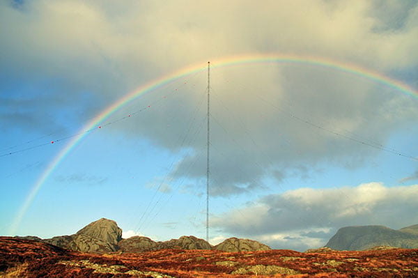
the former Loran-C transmission antenna at Værlandet, Norway. (Photo: UrsaNav)

Photo: UrsaNav

A PNT expert suggested that my piece titled “Opposite and Complementary: eLoran is part of the solution to GNSS vulnerability” in our November 2021 issue could be augmented with information not currently available on the proposed eLoran capability. This expert also questioned my statement that eLoran “does not have any common failure modes with GNSS” and pointed to potential common threats such as from cyberattacks, physical attacks, and space weather.

Matteo Luccio

Matteo Luccio

I welcome such feedback on the contents of these pages — and agree that in this case some hard questions are warranted. So, in the interest of further exploring the use of eLoran, I pose some questions, hoping that its advocates will provide answers. I know that at least some of them will not shy away from this challenge.

Please note that I wish to keep the discussion on positioning, not the easier question of timing, because that was the primary focus of my article. I also wish to address long-term outages (weeks or months), which would have a greater impact on the United States.

Some of these questions have been addressed, at least in part, in various studies and proposals, most of them now more than a decade old. So, it would be helpful to update those answers and consolidate them in the pages of this magazine.

1. Accuracy specifics. While my November article stated that eLoran would have a two-dimensional accuracy of “better than 20 meters, and in many cases, better than 10 meters,” is that RMS, 95%, or some other statistic?

2. Performance standard. GPS provides a commitment to users in a published performance standard. What specific measures of positioning accuracy, integrity and continuity would you recommend the proposed eLoran system be committed to provide (using the architecture described in the answer to Question 6)?

3. Coverage. Would you recommend this eLoran positioning performance hold for the entire United States (including Alaska, Hawaii, Puerto Rico and other territories), only for the “lower 48” states, or only parts of these 48 states?

4. Current users. By number of users, the predominant common current civil uses of GNSS for positioning are consumer devices (mostly cellphones). By contribution to the U.S. economy, the predominant uses are high-precision applications. For what fraction of these uses would eLoran positioning be adequate? Could an eLoran receiver and antenna fit in today’s consumer devices?

5. Future uses. Emerging civil uses of GPS for positioning include autonomous ground and air vehicles, navigation to space and in space, and lane-accurate car navigation. Which of these could be served by eLoran?

6. Architecture. To maintain accuracy during a prolonged GPS outage, eLoran would require reference stations to calibrate time-varying propagation errors, as well as a certain number of transmitters for good nationwide geometry and for redundancy, ensuring service even if a transmitter is attacked or is taken off-line for maintenance. What architecture would you recommend to achieve this?

7.  Infrastructure cost. What would be the cost of installing the required transmitters, power supplies, reference stations, communication links and control system for the architecture described in the answer to Question 6? Can you reference a recent and independent estimate? To a ballpark figure, what cost fixed-price contract would you accept to implement it? Similarly, what would be the annual costs for operating and maintaining this infrastructure?

8. Impact. eLoran transmitters are large and high-power. Providing positioning across the United States could require building some of them from scratch or significantly reconstructing old Loran sites. What issues — such as environmental, aviation safety and security — would this raise, and how would you recommend they be addressed?

9. Receivers. Assuming all the above were achieved, it would accomplish nothing unless eLoran receivers were widely purchased, installed and used. How much would that cost? Who would pay? Should we assume that “if we build it, they will come”?

10. Alternatives. Given the widespread development of other positioning technologies over the past decade, much has changed since the earlier recommendations for eLoran. How do we know that eLoran is the right investment — or even a needed part of the solution or needed system in a system of systems — for the future of U.S. PNT?

Common threats to GNSS and eLoran could include the following:

 
1. Cyber attacks. Given that GPS’s OCX is said to be the most cybersecure system built by the U.S. Department of Defense, how would eLoran’s control system be even more cybersecure than OCX, to avoid a common cyber-vulnerability?

2. Physical attacks. Given concerns about possible physical attacks on GPS satellites, which move at multiple km/sec 20,000 km from Earth, would it not be easier to physically attack eLoran transmitters, which are stationary, terrestrial, in remote locations, and hundreds of feet tall and require massive power sources?

3. Space weather. GPS is potentially vulnerable to severe space weather that could damage satellites or temporarily hinder signal propagation from space to Earth. However, severe space weather could also damage the power grid upon which megawatt eLoran transmitters rely. How would eLoran service be protected from the effects of severe space weather, such as a Carrington Event?

Send me your thoughts at the e-mail address below, with “eLoran” in the subject line.

Matteo Lucio | Editor-in-Chief
mluccio@northcoastmedia.net

Publicerad den Lämna en kommentar

RINEX 4.00 format now available

Logo: International GNSS ServiceThe RINEX Working Group of the International GNSS Service (IGS) is now available on the IGS website.

RINEX 4.00 (2021) is a major revision of the format document to modernize the navigation message files to be able to accommodate the new navigation messages from all the GNSS constellations, as well as system data messages such as ionospheric corrections, Earth orientation parameters and system time offsets.

The RINEX Working Group Chair Ignacio Romero provided an explanation to the GNSS community about the new RINEX 4.00 format that explains changes from previous RINEX versions.

The new format is also described in detail on the IGS Format and Standards page. For more information on the RINEX updates and activities, visit the RINEX WG Page.

The IGS adopted RINEX 4.00 during its  59th Governing Board Meeting on Dec. 7, 2021.

Publicerad den Lämna en kommentar

Space Force releases new GPS Roadmap, doc changes

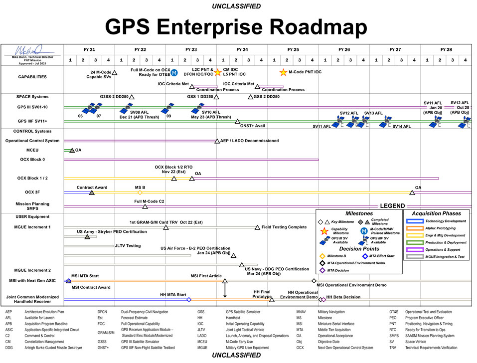
The U.S. Space Force has released a graph illustrating the GPS Enterprise Roadmap. The roadmap provides timelines for all the different elements of the GPS enterprise through the end of fiscal year 2028.

GPS Enterprise Roadmap. (Chart: U.S. Space Force)

GPS Enterprise Roadmap. (Chart: U.S. Space Force)

The agency has also released proposed change notices for several GPS-related public documents.

The link includes proposed changes for IS-GPS-200, IS-GPS-705 and IS-GPS-800 related to RFC-467 (2021 Proposed Changes to the Public Documents), as well as updated briefing charts for the 2021 GPS Public Interface Control Working Group (ICWG).

The updated documents reflect changes discussed at the 2021 Public ICWG on Sept. 29, 2021.

Publicerad den Lämna en kommentar

John Deere reveals fully autonomous tractor

Photo: John Deere

Photo: John Deere

John Deere has revealed a fully autonomous tractor ready for large-scale production. The machine combines Deere’s existing 8R tractor, a TruSet-enabled chisel plow, a GPS-based guidance system, and new advanced technologies.

The autonomous tractor has six pairs of stereo cameras, which enable 360-degree obstacle detection and the calculation of distance. Images captured by the cameras are passed through a deep neural network that classifies each pixel in 100 milliseconds and determines whether the machine continues to move or stops, depending on whether an obstacle is detected. The autonomous tractor  continuously checks its position relative to a geofence, ensuring it operates where it is supposed to, and is within less than an inch of accuracy.

John Deere Operations Center Mobile provides access to live video, images, data and metrics on a mobile device. Using the app, farmers can swipe from left to start the machine. While the tractor is working, the farmer can leave the field to focus on other tasks, while monitoring the machine’s status.

The app allows a farmer to adjust speed, depth and more. In the event of any job quality anomalies or machine health issues, farmers will be notified remotely and can make adjustments to optimize the performance of the machine.

Unveiled at the 2022 Consumer Electronics Show in Las Vegas on Jan. 4, the autonomous tractor will be available to farmers later this year.