Publicerad den Lämna en kommentar

EMCORE releases MEMs IMU

Photo: EMCORE Corporation

Image: EMCORE Corporation

EMCORE Corporation has released the TAC-440 MEMS inertial measurement unit (IMU). The TAC-440 IMU is designed for demanding, mission-critical, rugged environments in a wide variety of defense, commercial, industrial and marine applications.

The TAC-440 features 1°/hr gyro bias and 1 mg accelerometer bias stability with very low 0.05°/√hr angle random walk over a wide temperature range. The solid-state quartz sensors and hermetically sealed IMU construction provide reliable MTBF and storage life, EMCORE states.

The TAC-440 supports four data message synchronization methods with either input synchronization pulse capability or an output time of validity capability. The user can choose whether the synchronization pulse is internally generated and output as a time of validity of the output data or whether the TAC-440 software will identify the synchronization pulse input and synchronize the output data to the input pulse.

Publicerad den Lämna en kommentar

KP Performance Antennas launches vehicle GPS antenna

Image: KP Performance Antennas

Image: KP Performance Antennas

KP Performance Antennas has launched its line of vehicle GPS antennas designed for automotive applications.

These antennas come equipped with a high gain of 28 dB and high out-of-band rejection, allowing them to capture weak signals efficiently, even in challenging environments. By minimizing signal interference and multipath effects, the technology aims to provide signal quality and stability to users in applications such as personal vehicles, commercial fleets or autonomous systems.

With waterproof and dustproof ratings of IPX6 or IP66, the antennas can withstand varying outdoor conditions, offering uninterrupted performance even in inclement weather and rough terrains. This design makes them the ideal choice for vehicle tracking, fleet management, telematics and navigation systems.

Publicerad den Lämna en kommentar

Satellite imagery released in response to Libya flooding

Image: Maxar Technologies

Image: Maxar Technologies

On Sept. 10, floodwaters overpowered dams and wiped out entire neighborhoods in eastern Libya, taking the lives of thousands of people and displacing more than 40,000 people, reported the Associated Press.

Maxar Technologies has responded by publicly releasing satellite imagery data that maps the affected areas to support emergency response efforts as a part of its Open Data Program.

The Maxar imagery or data distributed through the program can be quickly integrated into first responder workflows with organizations such as Team Rubicon, the Red Cross and other nonprofits.

Derna and other parts of eastern Libya were hit with extreme flash flooding the night of Sunday, Sept. 10 — an effect of the Mediterranean storm, Daniel.

The National Meteorological Center of Libya had issued early warnings for Daniel 72 hours before it occurred and notified all governmental authorities by e-mail and through media urging them to take preventive measures, reported the Associated Press.

Publicerad den Lämna en kommentar

FocalPoint upgrades Supercorrelation technology

Image: FocalPoint

Image: FocalPoint

FocalPoint has added new functionality to its Supercorrelation technology, S-GNSS, to simplify the integration process for chipset companies.

The company has introduced an API interface between a GNSS chipset and an application or operating system that runs on its own navigation engine, easing deployment of Supercorrelation.

Based on the existing Android open-source interfaces, the S-GNSS API will allow a normal GNSS chipset to run S-GNSS in a separate external host processor. With this additional software added to the GNSS chipset, the overall system can get the performance improvements necessary to upgrade the GNSS receiver to a S-GNSS receiver and offer enhanced positional capabilities.

The S-GNSS API outputs the multipath-free line-of-sight correlation peak for each satellite and the corresponding corrected frequency, codephase and status flags. Optional outputs can be enabled with turn-on keys, spoofer detection and localization, and instantaneous magnetic-free heading estimation.

Supercorrelation has recently been awarded the National Technology award for Security Innovation of the Year and is recognized by the UK Royal Institute of Navigation and the Institute of Navigation. This development is the latest technical upgrade for the S-GNSS product portfolio.

Publicerad den Lämna en kommentar

Inside the box: New NavIC clock outperforms previous generation

Image: metamorworks/iStock/Getty Images Plus/Getty Images

Image: metamorworks/iStock/Getty Images Plus/Getty Images

NVS-01 is the first second-generation satellite of the Indian Navigation Satellite System (IRNSS), also known as Navigation with Indian Constellation (NavIC). It was launched into geostationary orbit on May 20. The satellite is placed at 129.6° eastern longitude and will finally replace IRNSS-1G launched in April 2016.

Whereas the first-generation satellites transmit navigation signals in the L5- and S-band, NVS-01 is the first IRNSS satellite also transmitting in the L1-band. The 1547.42 MHz frequency is also used by other satellite navigation systems, including GPS, Galileo, and BeiDou-3. However, a different modulation is used, namely a Synthesized Binary Offset Carrier (SBOC) signal. The IRNSS L1 SBOC signal has data and pilot components with and without navigation data. Data and pilot signals consist of BOC (1,1) and BOC (6,1) components with sub-frequencies of 1.023 MHz and 6.138 MHz. A quadrature multiplexing is applied for the data and pilot components with a power sharing of 41.82% and 58.18%. The navigation message on the IRNSS L1 signal has a different structure compared to those on the legacy L5- and S-band signals. The new L1 navigation message uses an advanced frame structure and forward error correction inherited from the CNAV-2 message of the GPS/QZSS L1C signal as well as a similar orbit model. Among other things, it provides inter-signal corrections for the L1 data and pilot signals with reference to the S band signal for single-frequency L1 band users.
NVS-01 started signal transmission on June 17, 2023, with the pseudo-random noise (PRN) code I10. The satellite’s L1 and L5 signals were tracked by a Septentrio PolaRx5 receiver located in Tokyo, Japan, with a prototype firmware that is capable of tracking the L1 pilot signal. Figure 1 shows the multipath linear combination of NVS-01’s L1 and L5 pilot signals. Whereas the short-term variations are smaller for L1 compared to L5, the overall RMS is 18 cm for both signals.

PFigure 1: Noise- and multipath linear combination for NVS-01’s L1 and L5 pilot signals received on 26 June 2023.

Figure 1: Noise- and multipath linear combination for NVS-01’s L1 and L5 pilot signals received on 26 June 2023. (Image: All figures provided by the authors) 

Whereas IRNSS-1’s rubidium clocks were provided by Spectratime, NVS-01 is the first satellite operating a new type of rubidium atomic frequency standard (RAFS) developed in India. The short-term performance of GNSS satellite clocks can be evaluated with the one-way carrier phase method. The receiver is connected to a highly stable external clock, e.g., a hydrogen maser. Thus, the receiver clock error is negligible. Measurement biases as well as the delays of ionosphere and troposphere on short time scales are removed by fitting a fourth-order polynomial. If no external clock is available, as is the case for the station in Tokyo, the precise clock information can be transferred from another station by a reference satellite jointly tracked by both receivers.

The Allan deviation based on this three-way carrier phase (TWCP) analysis is shown in Figure 2. The hydrogen maser of the IGS station USUD in Usuda, Japan, is used as the reference clock. At short integration times up to 20 s, the Allan deviation computed from the TWCP analysis is dominated by the GNSS measurement noise hiding the true clock performance. Above 20 s, the TWCP demonstrates that the NVS-01’s RAFS stability meets the performance of the ground tests and even exceeds them for longer integration times. At all integration times, the new RAFS outperforms the first generation IRNSS clocks.

Figure 2 IRNSS clock performance obtained from three-way carrier phase analysis as well as ground tests.

Figure 2: IRNSS clock performance obtained from three-way carrier phase analysis as well as ground tests.

Manufacturers

GNSS data used in this article were collected with a Septentrio PolaRx5 receiver.

Further Reading

Bandi TN, Arora R (2019) Indigenous Atomic Clock and Monitoring Unit for NavIC. ICG-14, https://www.unoosa.org/documents/pdf/icg/2019/icg14/WGD/icg14_wgd_09.pdf

ISRO (2022) NavIC Signal in Space ICD for Standard Positioning Service in L1 Frequency, Version 1.0. U.R. RAO Satellite Centre, Indian Space Research Organization, Bangalore, https://www.isro.gov.in/media_isro/pdf/SateliteNavigation/Draft_NavIC_SPS_ICD_L1_Oct_2022.pdf


Peter Steigenberger and Oliver Montenbruck are scientists at the German Space Operations Center of the German Aerospace Center (DLR), where they conduct research in the field of new satellite navigation systems.

Jean‑Marie Sleewaegen is Lead Architect at Septentrio, Belgium, where he has been responsible for GNSS signal processing, system design and technology development since the company’s inception in 1999.

Publicerad den Lämna en kommentar

u-blox launches new dual-band GNSS module


u-blox has released its latest positioning module, the NEO-F10N. The module is based on the u-blox NEO form factor and is equipped with u-blox F10 dual-band GNSS technology. It supports L1/L5 GNSS bands from multiple constellations, including NavIC, to provide solid meter-level position accuracy in urban areas.

The technology’s firmware is upgradeable and configurable to support a variety of applications such as vehicle aftermarket telematics and micromobility or industrial applications requiring meter-level position accuracy.

The NEO-F10N provides resilience against multipath interference and leverages signals from both the L1 and L5 bands. The module aims to increase accuracy, reduce power consumption and offer an alternative solution to users who do not want to deploy dead reckoning (DR) setups.

Users currently employing receivers based on modules, such as the u-blox NEO-M8 and NEO-M9, can seamlessly upgrade to the new NEO-F10N generation.

U-blox also introduces the new ANN-MB5 L1/L5 antenna to strengthen u-blox’s F10 dual-band solution. This tailored antenna offers an easy and reliable option for meter-level applications that require multi-band and multi-constellation support, even in challenging environments.

Publicerad den Lämna en kommentar

New Pentagon plan calls for UAV swarms to counter China, but is that enough?

Image: Navy Petty Officer 1st Class Devin M. Langer

Image: Navy Petty Officer 1st Class Devin M. Langer

The U.S. Department of Defense has called for thousands of UAVs to be built as a part of its Replicator initiative that aims to hasten military innovation to “leverage platforms that are small, smart, cheap and many,” said Deputy Defense Secretary Kathleen Hicks in a recent speech. This was cited in a Wall Street Journal editorial published on Sept. 13.

The United States plans to build thousands of UAVs over a 24-month period to counter China and the current military threat against U.S. forces in the Pacific Ocean. The UAV swarms could help the United States jam or distract enemy radars and surface-to-air missiles to stop China from pushing U.S. forces out of the Pacific.

The Wall Street Journal article stated that this idea by the Pentagon is not a real substitute for a bigger navy. While the Pentagon’s idea of UAV swarms for reconnaissance in the Pacific is technologically innovative, the article stated that the United States will still need technology breakthroughs and plentiful stocks of materials ranging from aircraft to munitions.

Furthermore, Deputy Hicks said that the Replicator initiative is not asking for new money in the next fiscal year budget, citing “not all problems need new money; we are problem-solvers, and we intend to self-solve,” reported the Wall Street Journal.

A new swarm of UAVs will give significant support to the U.S. military to counter China. However, the Pentagon’s quick plan for an unmanned technological “revolution” will need more investment to compensate for the failures that will inevitably accompany the new technology, the editorial argued, and to build “two Virginia-class submarines a year and fielding thousands of long-range weapons so U.S. forces don’t run out of their best firepower after a week in the Taiwan Strait.”.

Publicerad den Lämna en kommentar

Samples from DSEI Unmanned 2023

Defense and Security Equipment International (DSEI) in London just wrapped up last week and industry news circulated many reports of various unmanned-related releases and opportunities during the show.

Drawing more than1,500 visitors annually, DSEI is an event at which representatives from governments, armed forces and industry leaders meet to advance the technology of weapons systems. With mostly armed or armored exhibits, the show is aimed at demonstrating to British forces and others coming from around the world, the various advances in weapons-related products and activities — with technological advances taking a primary position throughout the meeting and the exhibit hall.

Some unmanned exhibits/notes of interest

Drone Evolution promoted its UK-built Sentinel tethered UAV and MPU5 mesh radio system that puts a UAV-mounted radio/camera/thermal imaging system more than 150 ft above the ground for up to 6 hr or more — typically to support intelligence gathering, surveillance / reconnaissance, force protection and security. Sentinel is capable of running off of 12 v or 24 v power such as from a field vehicle battery without an inverter or generator, but also through main power, the company states.

Elistair France also launched its Orion 2.2 TE tethered UAV with a 2-in-1 propeller configuration change, which allows it to carry a heavier 5 kg payload. A recently integrated Nextvision Raptor with a 3 km laser rangefinder provides continuous imagery, target tracking, automated object categorization, automated scanning routines, and points of interest for military units, border guards, and national security agencies. Elistair claims its Orion UAV is capable of continuous operations for more than 50 hr over a 328 ft tether.

Robosys Automation and Landau Marine announced a collaboration to convert regular marine vehicles into autonomous unmanned surface vessels (USV). UK’s Robosys provided the Voyager artificial intelligence (AI) vessel system — an autonomy solution using AI combined with decision-aids. These new USVs are capable of surveillance, surveying, warfare, and patrolling duties — Voyager AI is claimed to be vessel-, propulsion-, and sensor-systems agnostic and retrofitting a crewed vessel can result in an autonomous craft operating at speeds of up to 45 kn. The system provides collision avoidance, anti-grounding, smart object avoidance, and autonomous operation during loss of communications.

Orion 2.2 TE – Standard props (left) and with heavy-lift props (right). (Image: Elistair)

Orion 2.2 TE – Standard props (left) and with heavy-lift props (right). (Image: Elistair)

Robosys Automation and Landau Marine announced a collaboration to convert regular marine vehicles into autonomous unmanned surface vessels (USV). UK’s Robosys provided the Voyager artificial intelligence (AI) vessel system — an autonomy solution using AI combined with decision-aids. These new USVs are capable of surveillance, surveying, warfare, and patrolling duties — Voyager AI is claimed to be vessel-, propulsion-, and sensor-systems agnostic and retrofitting a crewed vessel can result in an autonomous craft operating at speeds of up to 45 kn. The system provides collision avoidance, anti-grounding, smart object avoidance, and autonomous operation during loss of communications.

Landau Marine USV conversion (Image: Landau)

Landau Marine USV conversion (Image: Landau)

W Autonomous Systems (WAS) released news of the first landing of an autonomous UAV on the UK Royal Navy’s aircraft carrier Prince of Wales while at sea off Cornwall, England. The WAS HCMC UAV involved has two engines and a twin boom tail and can carry 220 lb across 620 mi and land within 500 ft about half the length of the landing area on the Price of Wales aircraft carrier. For this trial, the UAV took off from a remote airfield at Royal Naval Air Station Culdrose and flew for 20 min to land autonomously on the deck of the HMS Prince of Wales aircraft carrier. The trials aimed to demonstrate that cargo UAVs are capable of relieving some of the re-supply tasks which are currently carried out by the ship’s helicopters. 

BAE Systems and QinetiQ signed an agreement at DSEI to collaborate on autonomous uncrewed air systems (UAS) and mission management systems. Both companies are leading competitive UK aerospace companies, and it’s perhaps unusual to see them collaborating. Perhaps this indicates the degree of importance and complexity that this development investment signifies. The mission management system work will investigate compatibility between BAE Systems and QinetiQ ground-based mission software systems, and develop autonomous systems that enable operator/human decision-makers to combine the use of both manned and unmanned assets on the battlefield. The companies will continue to develop their own airborne vehicles independently but aligned with the intent to continue their collaborative concepts.

HMS Price of Wales leaving Portsmouth UK on its way to rendezvous for the HCMC UAV autonomous deck landing at sea (Image: UK Ministry of Defence)

HMS Price of Wales leaving Portsmouth UK on its way to rendezvous for the HCMC UAV autonomous deck landing at sea (Image: UK Ministry of Defence)

In summary

This show is huge and this was only a small sample of the sort of unmanned and autonomous news found there this year — tethered UAVs, retrofitting surface vessels to become autonomous USVs, autonomous landings on the Royal Navy aircraft carrier Price of Wales and British industrial collaboration around UAVs.

Publicerad den Lämna en kommentar

Breaking down the F-35 jet “mishap”

Image: Lance Cpl. Kayla Rainbolt, Marine Corps Air Station Beaufort

Image: Lance Cpl. Kayla Rainbolt, Marine Corps Air Station Beaufort

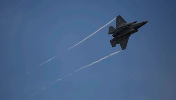
On Sept. 18, 2nd Marine Aircraft Wing Cpl. Christian Cortez, a pilot, set out on a training mission from the Marine Corps Air Station in Beaufort, South Carolina, only to eject from his Lockheed Martin F-35B Lightening II fighter jet over North Carolina. The U.S. military then lost the expensive, highly automated, lethal jet that was still in flight, as it was set on autopilot when the pilot ejected.

During the mishap, the U.S. Air Force Joint Base Charleston made a highly usual plea to the public to call with information regarding the lost plane. It is also still unclear why the pilot had to bail out of the jet and those details are actively under investigation.

The U.S. Marine Corps confirmed on Sept. 19, that debris had been found in South Carolina in Williamsburg County, north of Charleston, reported The New York Times. Joint Base Charleston stated the jet debris is located about two hours north of the base and it is urging residents to avoid the area as the recovery team secures the scene.

The jet search team consisted of the Second Marine Aircraft Wing, Navy regional authorities in the southeast, the Civil Air Patrol, the Federal Aviation Administration, and local law enforcement teams.

The Marine Corp released a statement on Sept. 18, stating that its acting commander, Gen. Eric M. Smith, had directed all Marine Corps aviation units to conduct a two-day pause in operations to discuss aviation safety matters and best practices. The statement said that the directive came after three Class-A aviation mishaps occurred during the last six weeks.

During the pause of operations, aviation commanders plan to review the service’s flight practices, procedures, and policies.

The jet

Lockheed Martin’s website states, “with stealth technology, advanced sensors, supersonic speed, weapons capacity and superior range, the F-35 is the most lethal, survivable and connected aircraft in the world. More than a fighter jet, the F-35’s ability to collect, analyze and share data, is a powerful force multiplier that enhances all airborne, surface and ground-based assets in the battlespace enabling men and women in uniform to execute their mission and return home safely.”

The F-35 program is the most expensive U.S. weapons program of all time and is expected to cost more than $400 billion in development and acquisition and $1.2 trillion to operate and maintain the fleet over 60 years. Each jet costs more than $160 million, depending on the variant.

Notable program advancements

Lockheed Martin reached a $4 billion deal with the Pentagon in 2014 to bring in the new fleet of F-35 jets.

In late 2019, Lockheed Martin received a $25 million initial contract for engineering and manufacturing development for the GPS Spatial Temporal Anti-Jam Receiver (GSTAR) system that was integrated into the F-35 as part of its modernization phase, also known as Block 4. The GSTAR provides protection against enemy jamming and spoofing by utilizing critical GPS capabilities that can quickly adapt to meet specific platform requirements.

Several unanswered questions

Several details of this story have left many wondering exactly how this U.S. fighter jet just went missing in U.S. airspace without anyone being able to locate it or know its heading. It is an expensive, highly automated, weaponized aircraft that can create catastrophic damage to its surroundings. 

As this investigation is ongoing, further details about this incident have not been reported.   

Publicerad den Lämna en kommentar

SingularXYZ launches upgraded auto-steering system

Image: SingularXYZ

Image: SingularXYZ

SingularXYZ has released the SAgro150 automated steering system for precision agriculture.

The product aims to provide farmers with an easy way to get started with auto-steering while increasing productivity. With full-constellation tracking capability, the SAgro150 realizes ±2.5cm auto-steering accuracy to maximizes land use and yield while saving resources such as water and fertilizer.

When compared to the first-generation SAgro100 system, the SAgro150 auto-steering system uses a single-antenna solution instead of a dual-antenna solution. It also features simpler integration options, only requiring a strong magnetic chuck to securely attach the antenna to the top of the tractor for satellite signal tracking. The new system also adopts dual gyroscope mode, enhancing the heading data reliability and compatibility with different tractors.

Upgraded from the SAgro100 auto-steering system, the SAgro150 has also inherited all of its advantages. Facing different tractor models, different farm terrains and working tasks.

The new system aids in work modes including rotary tillage, ridging, sowing and harvesting in straight line, curve, U-turn and more.