Publicerad den Lämna en kommentar

Seen & Heard: Space Force recruits with GPS

“Seen & Heard” is a monthly feature of GPS World magazine, traveling the world to capture interesting and unusual news stories involving the GNSS/PNT industry.


Photo: nattrass/iStock/Getty Images Plus

Photo: nattrass/iStock/Getty Images Plus

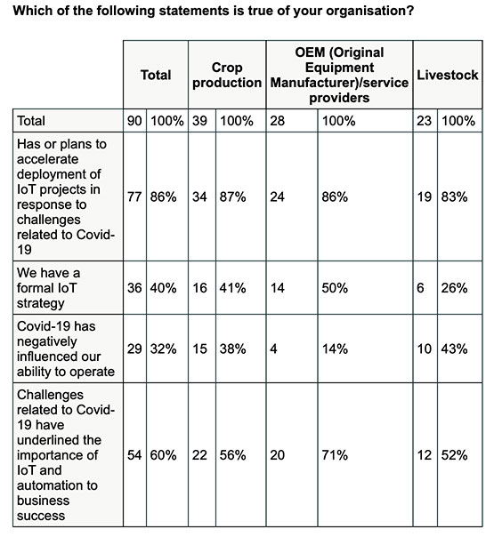
SMARTWATCH REVEALS RUNNER’S FATE

On the morning of July 10, Berkeley resident Philip Kreycik went for a run in Pleasanton, California. That day, temperatures reached 106 degrees, and he didn’t return home. His body was found Aug. 3, reports the San Francisco Chronicle. His Suunto smartwatch stopped tracking movement 4.5 hours after he started his run. GPS data from the watch showed him moving in erratic zigzags and circles before he stopped. Experts concluded he experienced delirium before succumbing to heat exhaustion.


Photo: SOPHIE-CARON/iStock Unreleased/Getty Images

Photo: SOPHIE-CARON/iStock Unreleased/Getty Images

GANGS TARGET FARM DEVICES

Organized gangs riding e-scooters are stealing high-value GPS/GNSS technology from farms in the United Kingdom, reports BBC News. Insurer NFU Mutual said the cost of replacing the stolen equipment nearly doubled in a year to £2.9 million. The technology, in worldwide demand, has become the “rural thieves’ top target,” the insurer said. GPS/GNSS equipment on tractors can cost up to £10,000 per unit.


SPACE FORCE RECRUITS WITH GPS

A 13-minute recruitment commercial from the U.S. Space Force debuted
Aug. 24, with GPS as a star. “There’s no such thing as a day without space operations. You just don’t see them,” explains the video, mentioning how GPS is key to the operation of ATMs, cell phones, gas pumps, traffic lights, power grids, guided missiles and more. The commercial states that the Space Force is seeking guardians who will help protect satellites from attack and debris. Current guardians describe the importance of GPS. “We won’t just think outside the box, we’ll think outside the atmosphere, in one of the most challenging environments ever known,” concludes the video. “The sky is not the limit.”


THIEVES STEAL TRACKERS AND… (GUESS THE REST)

Two burglars who stole a package from a drop-off box were quickly apprehended — the package was filled with Roambee GPS-based trackers heading to a COVID-19 vaccine maker for use in tracking shipments. The Santa Clara Police Department was ecstatic to learn what the thieves had stolen, reports Roambee, who knew the package had gone missing. Unaware of what was in their trunk, the thieves traveled more than 761 miles around the Bay Area before being arrested 14 days later on July 18.

Publicerad den Lämna en kommentar

2J Antennas launches GNSS, 5GNR and WiFi-6E combination 9-in-1 antennas

Photo: 2J Antennas

Photo: 2J Antennas

2J Antennas has introduced the Stellar series, antennas designed for a large suite of devices with a focus on GNSS, sub-6 GHz, 5G NR, 4G LTE, 3G, 2G and WiFi-6E technologies.

The Stellar Series is suitable for law enforcement, medical transportation, fire rescue and other applications where mission-critical communication is a requirement. The antennas are designed to reliably provide real-time connectivity in a small size.

This series includes single or up to 9-in-1 configuration choices within the range of 617 MHz to 7125 MHz frequency bands.

The patent-pending technology reduces the antenna footprint by 55% while implementing a new double trifilar design and longitudinal resonances for MIMO/ARRAY configurations that traditionally have more complex size restrictions (such as B71 band/600 MHz).

Each antenna configuration uses symmetrical or asymmetrical resonators for negative sections of the antenna, resulting in maximum performance at low and mid frequencies. The Stellar series offers magnetic and adhesive mounting choices, making them suitable for temporary installations.

For permanent installation, 2J Antennas also offers the screw mount option in its roof series. The low-profile and lightweight housing introduces a new design that offers a more cost-effective solution for suppliers and distributors.

“We are excited to reinvent antenna designs to meet the fast-growing global markets and offer antenna solutions with the highest quality while reducing antenna sizes as much as possible,” said Ruben Cuadras, director of engineering. “We are proud to continue to bring antenna solutions to customers that require small device integration, reliability and new designs.”

Publicerad den Lämna en kommentar

NGA launches new phase of Earth magnetic field project

Image: Credit: Petrovich9/iStock/Getty Images Plus/Getty Images

Image: Credit: Petrovich9/iStock/Getty Images Plus/Getty Images

The National Geospatial-Intelligence Agency launches Phase 4a of MagQuest Challenge to advance NASA’s ability to measure Earth’s magnetic field

The National Geospatial-Intelligence Agency (NGA) has launched the Demonstration Phase (Phase 4a) of its MagQuest Challenge to develop novel data-collection approaches for the World Magnetic Model.

The WMM ultimately ensures the accuracy of navigation, because it corrects for differences in magnetic forces at a user’s location. The model is used by thousands of systems for mobile navigation apps and is critical for military and commercial uses around the world.

Produced since 1905, the WMM originated with data collection from two ships surveying 500,000 miles of ocean. Today, the data is collected by satellites operated by the European Space Agency that will eventually reach the end of their useful life.

NGA’s MagQuest Challenge is promoting the development of miniaturized solutions to determine whether they can produce data useful to support WMM production. NGA has an extensive network of government partners collaborating on the WMM production, including the National Oceanic and Atmospheric Administration (NOAA), the British Geological Survey, the Federal Aviation Administration (FAA), the Department of Defense (DOD), the United States Geological Survey (USGS), and the United States Naval Observatory (USNO) among others.

As part of its core mission, NGA provides geospatial intelligence products and services to decision makers, military service members, and first responders.

The MagQuest Demonstration Phase 4a will take place on HeroX, a social network platform for crowdsourced solutions.

Three winning teams from Phase 3 of MagQuest each proposed a magnetometer design to measure the Earth’s magnetic field. In this new phase, the teams will receive several million dollars in awards, including a $1.55 million incentive prize purse, to develop their proposed magnetometers. NASA Goddard Space Flight Center will conduct independent testing on each team’s prototype.

Following Phase 4a, successful teams will integrate their magnetometers into their satellites and launch their systems, acquire data and share their results with NGA.

“Our ultimate goal is for all three teams to successfully develop a magnetometer, each of which can be sent into orbit to determine viability for WMM production,” said Mike Paniccia, NGA program manager for the World Magnetic Model. “We want to test as many innovative and groundbreaking magnetometers as possible to ensure that NGA has a robust set of data suppliers to support the future of the WMM. We intend to have a competitive procurement for a data-buy contract following MagQuest and hope that these three teams, in addition to others from industry, will be able to supply comprehensive data sets to support the future of the WMM.”

Three of the teams that participated in Phase 3 were selected to participate in Phase 4:

  • Iota Technology, the first-place Phase 3 winner, works alongside experienced teams from Oxford Space Systems and AAC Clyde Space. Their combined expertise in sensor technology, deployable structures and mission design informed the design of their SIGMA solution — a 3U CubeSat featuring a novel deployable boom and a 3D magnetometer array.
  • University of Colorado Boulder is one second-place Phase 3 winner, and their solution, COSMO, leverages recent innovations in CubeSat technology and novel magnetometer technology. The University of Colorado Boulder team includes experts and faculty from the Department of Aerospace Engineering Sciences, the Department of Mechanical Engineering, and the Laboratory for Atmospheric and Space Physics, and they operate their missions entirely at the university, including using their own ground stations.
  • Spire Global and SBQuantum formed a partnership with a promising approach to become the other second-place Phase 3 winner. SBQuantum’s novel diamond-based quantum magnetometer technology is coupled with Spire’s expertise and existing infrastructure in satellites, ground stations and data processing to produce a unique solution.

“This MagQuest Challenge is a testament to the power of the crowd,” said Kal K. Sahota, CEO, HeroX. “We are pleased to be part of securing the future of geomagnetic data collection and consequently contributing to the resilience and continued crucial work of the WMM.”

Publicerad den Lämna en kommentar

Geoscience Australia launches open-source GNSS corrections software

Geoscience Australia is developing open-source software — named Ginan — that will provide real-time corrections to positioning signals of all the GNSS constellations.

Once operational, Ginan will improve the accuracy of location data from 10 meters down to 3 to 5 centimeters for users with an internet and mobile connection. It will enable industry to provide reliable centimeter positioning to their customers, the agency said in a press release.

“Ginan is part of an exciting and innovative Australian Government program to enable precise positioning technology across the whole of the Australian continent,” said Martine Woolf, head of Geoscience Australia’s National Positioning Infrastructure Branch. “It will provide industry with the ability to use precise point positioning, bringing significant economic and social benefits to Australia.”

Examples of how this data could be used include reducing fertilizer and chemical spray waste in agriculture. It could also improve the operational efficiency of large mine sites through greater use of automation.

“Ginan will allow Australians to enjoy the benefits of precise positioning through the creation of new services and products, and in doing so, drive Australia’s economic growth,” Woolf said. “Our precise location data will inform of near real-time atmospheric conditions, which is already being used by the Bureau of Meteorology to assist with their weather predictions. It will also enable a greater understanding of movements in the Earth’s crust and provide insight into earthquakes, sea-level changes and the atmosphere.”

Ginan 1.0 will be publicly released in June 2022. An alpha version is now available on the Ginan GitHub repository, with a beta version planned for user testing from February 2022.

Ginan concept overview. This diagram illustrates how Australia’s network of GNSS ground station infrastructure streams GNSS satellite observations for Ginan to process and analyze, providing correction data to users through an internet connection. (Diagram: Geoscience Australia)

Ginan concept overview. This diagram illustrates how Australia’s network of GNSS ground station infrastructure streams GNSS satellite observations for Ginan to process and analyze, providing correction data to users through an internet connection. (Diagram: Geoscience Australia)

A thoughtful name

Ginan is named for a star that aided the First Australians as they navigated across the continent.

Woolf said the name of the software is a gift from the Wardaman people from the Northern Territory. Geoscience Australia sought permission to use the name Ginan as part of its commitment to respectfully engage and collaborate with Australia’s First Peoples.

“In the language of the Wardaman people, Ginan means ‘a red dilly-bag filled with songs of knowledge’. We like to think of this software as being similar to a dilly-bag full of knowledge because of the benefits it will unlock,” Woolf said. “Ginan is also the name of the fifth-brightest star in the Southern Cross. Just as the Southern Cross helped the First Australians to navigate this land, the positioning capability we are developing here at Geoscience Australia will enable us to know exactly where we are and where we are going.”

Wardaman Elder Diganbal Rosas said the dilly-bag was an important part of the Wardaman songline of the Katherine region. Songlines help to culturally and physically map land and seas through the transmission of traditional knowledge, cultural values, lore and wisdom across the landscapes. They are a living ancient memory code linking the environment, language and culture.

“Ginan [in our language] has all of the Wardaman knowledge regarding connection to country — all of the stars, the skies, the country, the people and the kinship. Everything we do is held in that dilly-bag, in that Ginan,” Rosas said. “The star teaches us many aspects of that spiritual connection to country, how it all began through those songlines, and how that story connects country to the stars. It is significant [that the Wardaman people have allowed Geoscience Australia to use this name] and I think it is a great opportunity for us to showcase our partnership.”

The Ginan initiative is part of Geoscience Australia’s Positioning Australia program, which is improving the accuracy of location-based data across the nation, bringing it from meters to centimeters.

Further information

Ginan Analysis Centre Software
Ginan GitHub repository
Positioning Australia

Photo: intst/iStock/Getty Images Plus/Getty Images

Photo: intst/iStock/Getty Images Plus/Getty Images

Publicerad den Lämna en kommentar

Septentrio and SBG Systems partner on Qinertia post-processing

Septentrio now offers Qinertia post-processing software from SBG Systems on AsteRx-i3 D Pro+, AsteRx-i3 S Pro+ and AsteRx SBi3 Pro+ receivers

Septentrio will now offer post-processing solutions for its GNSS/INS (inertial navigation system) receivers, using SBG Systems’ Qinertia software.

The AsteRx-i3 Pro+ receivers are fully compatible with Qinertia post-processing software, so no data manipulation is required before the post-processing step.

Land or aerial mapping applications, which do not have access to real-time GNSS corrections, benefit from post-processing software for higher positioning and orientation (heading, pitch and roll) accuracy. With the addition of post-processing, Septentrio GNSS/INS products cover the full mapping workflow.

“As a result of our cooperation with SBG Systems, Septentrio’s mapping customers who use GNSS/INS are benefiting from a quicker and more reliable workflow,” said Danilo Sabbatini, product manager at Septentrio. “The intuitive user interface of Qinertia software makes it easy for users to further improve their positioning and orientation accuracy in the post-processing step.”

In case of GNSS outage or correction link failure, post-processing recovers accuracy for recorded positioning and inertial data.

After the mission, Qinertia gives access to real-time kinematic (RTK) corrections from more than 8,000 base stations to deliver centimeter level accuracy. Trajectory and orientation are greatly improved by post processing GNSS and IMU data forward and backward. The Qinertia GNSS/INS post-processed kinematic (PPK)  solution provides accuracy, reliability, advanced quality-control indicators, and a modern application programming interface (API).

Qinertia recently added an image geotagging feature, and specific outputs dedicated to photogrammetry.

Qinertia post-processing software will be used on Septentrio receivers. (Photo: SBG Systems)

Qinertia post-processing software will be used on Septentrio receivers. (Photo: SBG Systems)

Publicerad den Lämna en kommentar

Virginia Tech’s Mark Psiaki receives ION’s Kepler Award

Mark Psiaki received the  2021 Johannes Kepler Award. (Photo: ION)

Mark Psiaki received the  2021 Johannes Kepler Award. (Photo: ION)

The Institute of Navigation’s (ION) Satellite Division presented two prestigious awards Sept. 24 at its ION GNSS+ 2021 Conference, which took place in St. Louis, Missouri.

Mark Psiaki received the  Johannes Kepler Award for setting a standard of rigor, clarity and thoroughness in addressing key estimation and signal processing problems in positioning, navigation and timing (PNT).

The Johannes Kepler Award recognizes and honors an individual for sustained and significant contributions to the development of satellite navigation. It is the highest honor bestowed by the ION’s Satellite Division.

Psiaki originated the technique of bit-wise parallel RF signal processing for use in general-purpose processors. This enabler of software-defined GNSS led to the first space deployment of a fully software-defined GNSS receiver on a general-purpose digital signal processor (DSP) and to the widespread adoption of software-defined GNSS across the aerospace industry.

Psiaki’s real-time software radio expertise also enabled the development of a spoofer cultivated in his research group. He led the development of spoofing detection algorithms based on cross-correlation of unknown P(Y) codes and based on direction-of-arrival sensing.

Psiaki was the lead signal processing designer/analyst for the iGPS program that combined Iridium L-band downlink signals, GPS signals and inertial navigation system (INS) data to enhance GPS anti-jam capabilities. Recent work on navigation based on low-Earth-orbit (LEO) satellites fuses observables from an existing global communications constellation with INS and other sensor data to provide a backup to GPS.

Another contribution demonstrates how Doppler-based navigation could replace pseudorange-based navigation if implemented using a large LEO constellation.

DPsiaki has made many contributions to the practice of modeling, estimation, and detection applied to GNSS, including the study of GNSS carrier phase modeling for space-based applications.  His campaign to decode the GIOVA-A L1 BOC(1,1) PRN codes enabled Galileo receiver manufacturers to test their systems before the ESA published the codes.  His group’s work on ionospheric scintillations led to the first commercially-available scintillation simulators.

Psiaki holds the Kevin T. Crofton Faculty Chair of Aerospace & Ocean Engineering at Virginia Tech.  He studied at Princeton University, completing a B.A. in physics in 1979 (magna cum laude) followed by an M.A. (1984) and a Ph.D. (1987) in mechanical and aerospace engineering.

He is a past recipient of the ION’s Burka Award, its Tycho Brahe Award, and the Pride at Boeing Accomplishment Award. He is a Fellow of both the AIAA and the ION.

PARKINSON AWARD

Lakshay Narula with Brad Parkinson. (Photo: ION)

Lakshay Narula with Brad Parkinson. (Photo: ION)

The Institute of Navigation’s (ION) Satellite Division also presented Lakshay Narula with its Bradford W. Parkinson Award for his thesis, “Towards Secure & Robust PNT for Automated Systems.”

The Bradford W. Parkinson Award is given annually to an outstanding graduate student in the field of GNSS. The award, which honors Parkinson for his leadership in establishing both GPS and the Satellite Division of the ION, includes a personalized plaque and a $2,500 honorarium.

Any ION member who is a graduate student completing a degree program with an emphasis in GNSS technology, applications or policy is eligible for the award.

Publicerad den Lämna en kommentar

Robotic ‘white cane’ helps visually impaired navigate indoors

News from the National Institutes of Health

Study author Lingqiu Jin tests the robotic cane. (Photo: Cang Ye, VCU/NIH)

Study author Lingqiu Jin tests the robotic cane. (Photo: Cang Ye, VCU/NIH)

A new robotic cane can help the visually impaired navigate indoors. The cane is equipped with a color 3D camera, an inertial measurement sensor, and its own on-board computer.

When paired with a building’s architectural drawing, the device can accurately guide a user to a desired location with sensory and auditory cues, while simultaneously helping the user avoid obstacles like boxes, furniture and overhangs.

Development of the device was co-funded by the National Institutes of Health’s National Eye Institute (NEI) and the National Institute of Biomedical Imaging and Bioengineering (NIBIB). Details of the updated design were published in the journal IEEE/CAA Journal of Automatica Sinica.

“Many people in the visually impaired community consider the white cane to be their best and most functional navigational tool, despite it being century-old technology,” said Cang Ye, Ph.D., lead author of the study and professor of computer science at the College of Engineering at the Virginia Commonwealth University, Richmond. “For sighted people, technologies like GPS-based applications have revolutionized navigation. We’re interested in creating a device that closes many of the gaps in functionality for white cane users.”

While cellphone-based applications can provide navigation assistance — helping blind users stay within crosswalks, for example — large spaces inside buildings are a major challenge, especially when those spaces are unfamiliar.

Earlier versions of Ye’s robotic cane began tackling this problem by incorporating building floorplans; the user could tell the cane where he or she wished to go, and the cane — by a combination of auditory cues and a robotic rolling tip — could guide the user to the destination. But when used over long distances, the inaccuracies in the user’s location could build up, eventually leaving the user at an incorrect location.

To help correct this issue, Ye and colleagues have added a color-depth camera to the system. Using infrared light, much like a mobile phone’s front-facing camera, the system can determine the distance between the cane and other physical objects, including the floor, doorways and walls, as well as furniture and other obstacles. Using this information, along with data from an inertial sensor, the cane’s onboard computer can map the user’s precise location to the existing architectural drawing or floorplan, while also alerting the user to obstacles in their path.

“While some cell phone apps can give people auditory navigation instructions, when going around a corner for example, how do you know you’ve turned just the right amount?” said Ye. “The rolling tip on our robotic cane can guide you to turn at just the right point and exactly the right number of degrees, whether it’s 15 or 90. This version can also alert you to overhanging obstacles, which a standard white cane cannot.”

There are still a few kinks to be worked out before the system will be market-ready — it’s still too heavy for regular use, for example, and Ye’s team is looking for a way to slim down the device.

Nevertheless, with the ability to easily switch between its automated mode and a simpler, non-robotic “white cane mode,” Ye believes the device could provide a key independence tool for the blind and visually impaired, without losing the characteristics of the white cane that have stood the test of time.

The study was funded by NEI and NIBIB through grant EB018117.

Reference: Zhang H, Jin LQ, Ye C. “An RGB-D camera based visual positioning system for assistive navigation by a robotic navigation aid,” IEEE/CAA J. Autom. Sinica. 2021. 8(8):1389-1400. doi:10.1109/JAS.2021.1004084

Publicerad den Lämna en kommentar

Roscosmos to deploy GLONASS monitoring stations in five countries

Roscosmos plans to place GLONASS ground stations in Brazil, China, Indonesia, India and Angola, reports the TASS news agency.

“In the near future, another six non-request measuring stations are to be placed abroad: two in Brazil (Belem and Colorado de Oeste), one in China (Shanghai), one in Indonesia (Bukittinggi, West Sumatra), one in India (Bangalore) and one in Angola (Luanda),” the corporation said.

Negotiations with foreign partners have been held. On-site reconnaissance work has been carried out and contracts are being coordinated.

Publicerad den Lämna en kommentar

Inmarsat: Ag accelerates IoT adoption in response to COVID-19

Image: William_Potter/iStock/Getty Images Plus/Getty Images

Image: William_Potter/iStock/Getty Images Plus/Getty Images

New Inmarsat research reveals a rapid increase in levels of industrial IoT maturity in 2021, with agricultural businesses accelerating IoT adoption in response to COVID-19

Research by Inmarsat, a global mobile satellite communications company, reveals a rapid increase in the maturity level of the industrial internet of things (IoT) across the agricultural sector since the start of the COVID-19 pandemic, with 86% of ag business accelerating or intending to accelerate deployment.

Respondents in the report, “Industrial IoT in the Time of COVID-19,” include crop producers, OEMs, service providers and livestock businesses, who report that COVID-19 demonstrated the importance of IoT to their businesses.

According to the research, adoption has seen huge progress from 2020 to 2021, with automation and cost savings the greatest drivers. Four-fifths (80%) of agricultural respondents have now fully deployed at least one IoT project, with 53% having achieved this in the 12-month period from the second quarter of 2020. Of the remaining 20% of agricultural respondents that have not yet adopted IoT in any form, all of them are either currently trialing it, or plan to deploy or trial at least one IoT project in the next two years.

Chart: Inmarsat

Chart: Inmarsat

A further 86% of agricultural respondents indicated they have or they intend to accelerate the adoption of IoT in response to challenges related to COVID-19. This figure includes 46% who have already accelerated IoT adoption to respond to COVID-19, versus 29% who will accelerate over the next 12 months and 11% who will accelerate beyond the next 12 months.

The 46% that have already accelerated IoT adoption are less likely to state that COVID-19 has negatively impacted their ability to operate, demonstrating a link between IoT and business continuity during the pandemic. Additionally, more than half (60%) of respondents in the sector indicated that business and operational challenges related to COVID-19 have underlined the importance of IoT.

“We have seen agricultural producers take on more and more solutions that allow them to operate remotely, from autonomous irrigation control to the latest precision farming technologies, demonstrating increased faith in the technology,” said Steven Tompkins, Director of Market Development at Inmarsat.

As part of the research, Inmarsat is offering businesses the opportunity to measure their IoT readiness compared to the respondents in the survey, using their free IoT maturity tool.

Publicerad den Lämna en kommentar

Hexagon introduces Security & Surveillance portfolio for rail

The Security & Surveillance portfolio for rail. (Image: Hexagon)

The Security & Surveillance portfolio for rail. (Image: Hexagon)

Hexagon’s Safety, Infrastructure & Geospatial division, in partnership with Hexagon’s Geosystems division, has introduced Hexagon’s Security & Surveillance portfolio for rail.

Comprised of an integrated set of solutions proven in rail operations around the globe, the portfolio unites 3D surveillance systems with best-in-class security, dispatching and collaboration software. It enables rail operators to better protect their assets, passengers and freight to reduce disruptions and improve safety and customer satisfaction.

The portfolio addresses the complete lifecycle of incident management, empowering operators to detect, assess and respond to threats and incidents and collaborate with outside organizations when needed. It includes:

  • Detect: Leica BLK247 and accur8vision 3D security and surveillance systems go beyond traditional 2D security cameras by integrating lidar, thermal sensors, video and 3D planning and tracking software for high-value areas, perimeters and zones, such as tunnels and rolling stock.
  • Assess: HxGN OnCall Security | Guardian provides a common operational picture for alarms, sensors, the internet of things, intrusion devices and video data to deliver situational awareness for real-time event monitoring.
  • Respond: HxGN OnCall Dispatch, a computer-aided dispatch solution with embedded assistive artificial intelligence, allows control room operators to dispatch resources to respond to incidents.
  • Collaborate: HxGN Connect facilitates collaboration and information sharing between internal teams and external entities to ensure stakeholders are informed and engaged during events.

“Globally, passenger and freight traffic are expected to double by 2050, which means rail operators must begin investing in safer rail operations now,” said Juergen Dold, President, GSI, Hexagon. “Rail networks have a broad spectrum of security needs, and Hexagon’s Security & Surveillance portfolio uniquely spans different hazards, capabilities and teams. It offers scalable solutions that seamlessly transition from simple security monitoring to emergency response to collaboration among diverse teams during complex operations.”

Hexagon’s Security & Surveillance portfolio builds on Hexagon’s capabilities for rail safety and security operations. Every year, Hexagon solutions protect more than 5 billion rail and transit passengers around the world. In North America alone, the company’s technologies help protect more than 56,000 miles of railways.