
Veronte Curve-based navigation in UAV operations
Press
2 June 2017
One of the most innovating and exclusive features of Veronte Autopilot is its curve-based navigation capacity in UAVs operations, becoming the pioneer autopilot to incorporate this technology. This kind of navigation allows to define missions made of an unlimited quantity of points and lines, either curved or straight, replacing the traditional “Waypoints”.
Curve-based navigation allows to perform turns softly, stablishing a custom configuration for each UAV. The Veronte Autopilot allows to configure a maximum “bank angle” and the minimum turn radius that the UAV supports, so when operating, the UAV doesn’t perform sudden turns.
In addition to the curves navigation feature, Veronte Autopilot also permits the possibility to perform Above Ground Level (AGL) flights to keep a specific height considering the ground itself, or Mean Sea Level (MSL) flights to keep the height in relation to the sea level.
APPLICATIONS THAT TAKE BENEFIT FROM CURVE-BASED NAVIGATION
There are different applications that take benefit from the use of curve-based navigation, optimising UAVs operations. This optimisation is maximised due to the use of Veronte Autopilot together with its control software Veronte Pipe, since the latter includes one-click auto missions.
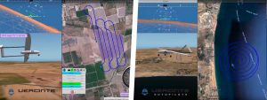
On applications such as mapping or capsule dropping with UAVs, the turn radius is configured to let curve-based navigation to establish the turns the UAV has to perform outside the mapping area. On this way, the aircraft would go back into the mapping area with the ortographic camera on a straight line/course to continue its mission.
In “Search and Rescue” operations, curve-based navigation allows to configure on a single click a spiral flight, opening the radius from the searching point to perform an exhaustive scanning of the area to trail. On the same way, it is possible to perform the mapping of windmills and other vertical structures, configuring an ascending spiral flight to surround the structure to inspect.
Content retrieved from: https://www.suasnews.com/2017/06/veronte-curve-based-navigation-uav-operations/.