Publicerad den Lämna en kommentar

Septentrio and CORE receiver will use Japan’s centimeter-level service

Septentrio and CORE partner up to develop a GPS/GNSS receiver which will make use of Japan’s Centimeter-Level Augmentation Service (CLAS). CLAS corrections are broadcast directly via QZSS constellation to enable high-accuracy positioning across Japan.

Septentrio, a leader in high-precision GNSS technology, and CORE, a Japanese system integrator with extensive experience in GNSS, are jointly developing a receiver that can use the Centimeter-Level Augmentation Service (CLAS) of Japan’s Quasi-Zenith Satellite System (QZSS).

Septentrio’s multi-frequency GPS/GNSS receiver AsteRx4 will be used as a platform for the development of CLAS functionality. Septentrio receivers already track the L6 signal and can use QZSS for increased positioning availability and reliability.

CORE’s know-how will be instrumental for the deployment of CLAS on Septentrio receivers. The two companies are planning to launch their CLAS-enabled receiver in January 2020.

Japan’s CLAS is a self-augmentation GNSS correction service. Without the need for a ground link, it allows real-time kinematic (RTK) centimeter-level positioning all over Japan with convergence times of less than a minute.

It does this by broadcasting GNSS corrections directly via QZSS satellites, also known as Michibiki. These corrections are generated from the dense network of reference stations operated by Japan’s Geospatial Authority.

The two companies have also entered into a distribution contract that allows CORE to sell Septentrio high-precision positioning technology, including CLAS-capable GNSS receivers, in the Japanese market.

The new CLAS-enabled receiver will also incorporate Septentrio’s Advanced Interference Mitigation (AIM+) technology. In busy urban environments electromagnetic waves can interfere with GPS and GNSS signals.

AIM+ offers protection against such interference resulting in faster set-up times and robust continuous operation.

“QZSS Centimeter Level Augmentation Service has been limited to evaluation phase up till now. Realizing CLAS on Septentrio’s multifunctional, high-quality, cost-competitive platform allows our customers to finally use QZSS in their applications,” emphasized Takahiro Yamamoto, Director of GNSS Solution Development Center at CORE Corporation. “Galileo High Accuracy Service (HAS) is expected to start in 2020, so the demand for high accuracy GNSS receivers is also expected to increase. By complementing CORE’s QZSS technology and Septentrio’s Galileo technology, we can provide competitive products to global customers.”

“CLAS is a first-of-its-kind service which will contribute to the proliferation of high accuracy GNSS applications in Japan. Europe is also taking similar initiatives with their Galileo High Accuracy Service (HAS),” commented Neil Vancans, Director of Global Sales at Septentrio. “We are excited to enter into an agreement with CORE to enable the support of CLAS on our receivers. CORE’s expertise allows us to get the best out of CLAS and to follow new developments in QZSS evolution. Moreover, CORE’s expertise in system integration will allow us to tackle new markets in Japan.”

Publicerad den Lämna en kommentar

How do we ensure GNSS security against spoofing?

By Maria Simsky
Technical Writer, Septentrio

As technological advances make GPS/GNSS devices more affordable, our lives are becoming increasingly dependent on precise positioning and timing. Industries such as survey, construction and logistics rely on precise positioning for automation, efficiency and safety.

GNSS time provides the pulsating heartbeat for the backbone of our industry by synchronizing telecom networks, banks and the power grid. A single day of GNSS outage is estimated to cost $1 billion U.S. dollars alone.

GNSS is a reliable system, and to keep it as such, professional GNSS receivers need to be wary of all possible vulnerabilities which could be exploited. Using GNSS receivers that are robust against jamming and spoofing is key for secure PNT (positioning, navigation and timing).

What is GPS/GNSS spoofing?

Radio interference can overpower weak GNSS signals, causing satellite signal loss and potentially loss of positioning. Spoofing, is an intelligent form of interference which makes the receiver believe it is at a false location. During a spoofing attack a radio transmitter located nearby sends fake GPS signals into the target receiver. For example, a cheap software-defined radio (SDR) can make a smartphone believe it’s on Mount Everest!

Figure 1. A cheap SDR can overpower GNSS signals and spoofs a single-frequency smartphone GPS into believing it is on Mount Everest. (Image: Septentrio)

Figure 1. A cheap SDR can overpower GNSS signals and spoofs a single-frequency smartphone GPS into believing it is on Mount Everest. (Image: Septentrio)

Why GPS spoofing?

Imagine a combat situation. Clearly, the side which uses GPS/GNSS technology would have an advantage over the side which does not. But what if one side could manipulate GPS receivers of their adversary? This could mean taking over control of autonomous vehicles and robotic devices which rely on GPS positioning.

For example, in October 2018, Russia accused the U.S. of spoofing a drone and redirecting it to attack a Russian air base in Syria.

Figure 2. GNSS spoofing could be used to manipulate movement of aerial drones. (Image: Septentrio)

Figure 2. GNSS spoofing could be used to manipulate movement of aerial drones. (Image: Septentrio)

In the last three years, more than 600 incidents of spoofing have been recorded in the seas near the Russian border. These ships appeared to be “transported” to nearby airports.

This type of spoofing might have been introduced as a defense mechanism to ground spy drones. Most semi-professional drones on the market have a built-in geo-fencing mechanism that lands them automatically if they come close to airports or other restricted areas.

Some of the most enthusiastic spoofers are Pokémon GO fans who use cheap SDRs to spoof their GPS position and catch elusive Pokémon without having to leave their room.

Types of spoofing

Spoofers overpower relatively weak GNSS signals with radio signals carrying false positioning information. There are two ways of spoofing:

  1. Rebroadcasting GNSS signals recorded at another place or time (so-called meaconing)
  2. Generating and transmitting modified satellite signals

Spoof-proof: How can you protect your receiver against spoofing?

To combat spoofing, GNSS receivers need to detect spoofed signals out of a mix of authentic and spoofed signals. Once a satellite signal is flagged as spoofed, it can be excluded from positioning calculation.

GNSS receivers can offer various levels of spoofing protection. Let’s compare it to a house intrusion-detection system. You can have a simple entry alarm system or a more complex movement detection system. For added security you might install video image recognition, breaking-glass sound detection or a combination of the above.

Like a house with an open door, an unprotected GNSS receiver is vulnerable to even the simplest forms of spoofing. Secured receivers, on the other hand, can detect spoofing by looking for signal anomalies, or by using signals designed to prevent spoofing such as Galileo OS-NMA and E6 or the GPS military code.

Advanced interference mitigation technologies, such as the Septentrio AIM+, use signal-processing algorithms to flag spoofing by detecting various anomalies in the signal. For example, a spoofed signal is usually more powerful than an authentic GNSS signal.

AIM+ won’t even be fooled by an advanced GNSS signal generator: Spirent GSS9000. With realistic power levels and with actual navigation data within the signal, AIM+ can identify it as a “non-authentic” signal.

Other advanced anti-spoofing techniques such as using a dual-polarized antenna are being researched.

Satellite navigation data authentication

Various countries invest in spoofing resilience by building security directly into their GNSS satellites. With OS-NMA (Open Service Navigation Message Authentication), Galileo is the first satellite system to introduce an anti-spoofing service directly on a civil GNSS signal.

OS-NMA is a free service on the Galileo E1 frequency. It enables authentication of the navigation data on Galileo and even GPS satellites. Such navigation data carries information about satellite location and if altered will result in wrong receiver positioning computation. While currently in development, OS-NMA is planned to become publicly available in the near future. Also GPS is experimenting with satellite based anti-spoofing for civil users with their recent Chimera authentication system.

Figure 3. European Galileo satellites provide an open authentication service on the E1 signal and a commercial authentication service on the E6 signal. (Image: European Space Agency)

Figure 3. European Galileo satellites provide an open authentication service on the E1 signal and a commercial authentication service on the E6 signal. (Image: European Space Agency)

Recently, within the scope of the FANTASTIC project led by GSA, OS-NMA anti-spoofing protection was implemented on a Septentrio receiver.

The strongest shield: signal-level GNSS authentication

The Galileo system will be offering Commercial Authentication Service (CAS) on the E6 signal with the highest level of security for safety-critical applications such as autonomous vehicles. The signal level encryption will be based on similar techniques as the military GPS signals. Only the receivers who have the secret key are able to track such encrypted signals. The secret key is also needed to generate the signal making it impossible to fake. CAS authentication techniques are currently being prototyped at Septentrio in collaboration with the European Space Agency.

Spoof-resilient GNSS means reliable precise positioning and timing, and a peace of mind for everyone touched by this indispensable technology.

References

  1. Study finds that a GPS outage would cost $1 billion per day
  2. Russia Claims US Spoofed Drones to Attack Base
  3. Spoofing in the Black Sea: What really happened?
  4. Technical paper by Septentrio – Authentication by polarization: a powerful anti-spoofing method
  5. New Report Details GNSS Spoofing Including Denial-of-Service Attacks
Publicerad den Lämna en kommentar

Seen & Heard: Golf play, corn mazes and Google Maps

“Seen & Heard” is a monthly feature of GPS World magazine, traveling the world to capture interesting and unusual news stories involving the GNSS/PNT industry.


Photo: MazePlay.com

Photo: MazePlay.com

There’s an app for that

For 17 years, Kersey Valley Attractions in Archdale, N.C., created its annual corn maze by using a GPS-enabled tractor to cut paths out of grown corn. Instead of being limited by a tractor’s turning radius, this year’s “Maize Adventure” used a GPS planter programmed with a maze design from the MazePlay app. Based in Idaho, MazePlay provides maze design and cutting services throughout North America. The Apollo 11 example here is from Richardson Adventure Farm in Spring Grove, Illinois.


Photo: BMW

Photo: BMW

Just hit it already!

To speed play, officials for the PGA European Tour are using a GPS tracking system. Tracking devices were placed on one golf bag in each group in the BMW Championship, held Sept. 19–22 in Surrey, UK. When a group completed a hole, the information was sent to officials and displayed at five holes. Next year, all 18 holes will have displays, which include player names and indicate if the group is behind. The tour plans to increase fines for pace-of-play violations.


Photo: iStock.com/gchapel

Photo: iStock.com/gchapel

GPS makes it (too?) easy

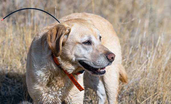
Animal rights groups are suing California over rules that allow animals to be hunted with the aid of hunting dogs wearing GPS tracking devices on their collars. The Animal Legal Defense Fund called the hunting method “unusually cruel and unfair” because tracking devices allow dogs to chase prey to the point of exhaustion, and then hunters follow the GPS signal to find an animal that can no longer flee and is easily shot. The lawsuit says the commission violated state environmental law by failing to conduct an assessment of how the use would affect wildlife.


Photo: Google

Photo: Google

Google Maps come alive

Google Maps is beta testing a new Live View feature, allowing travelers to use augmented reality (AR) to better see which way to go. Arrows and directions are placed in the real world to guide the walker. Google has tested Live View with its Local Guides and Pixel community for several months, and has now expanded the beta to Android and iOS devices that support ARCore and ARKit.

Publicerad den Lämna en kommentar

Raytheon adopts tech-startup processes for OCX

Raytheon plans to deliver the final phase of the GPS Ground Control System (OCX) upgrade to the United States Air Force by June 2021, despite past delays to the program.

A report by the General Accountability Office (GAO), issued in May, said the Air Force has yet to develop full cost estimates for the new ground system, as well as the user equipment needed to access the expanded capabilities of GPS III.

In the report, the GAO recommended that the Department of Defense (D0D) conduct an independent schedule assessment of the full program schedule at the end of 2019. DOD did not agree with the recommendation.

“OCX delivery, acceptance, and the ready to transition to operations decision will likely be delayed, potentially exceeding the April 2023 threshold date for completing the program,” the GAO report said.

However, Raytheon said Oct. 1 that it had completed software and hardware development and has started testing and integrating the system, keeping it on track to meet its contractual deadline.

In an Oct. 1 Denver Post article, David Wajsgras, president of Raytheon’s Intelligence, Information and Services business, said Raytheon has changed its process for the OCX upgrade by adopting less-traditional tech startup development processes.

The new process —now in action at Raytheon’s Aurora, Colorado, campus — emphasizes collaboration across teams and has a less linear structure.

“I’d call it almost a 180 from the way we had developed software in the past, from the traditional way for the Department of Defense,” Wajsgras told the Post.

“A few years ago the GPS OCX program was considered the No.1 problem program in the entire Department of Defense,” Wajsgras acknowledged. “Our team truly stepped up to the challenge of what needed to be done in order to get one of the most important programs for U.S. government back on track.”

DOD’s Defense Digital Service helped the company apply an “agile” approach to “DevOps” (development and operations) that stresses collaboration across teams as well as flexibility.

The new process includes “dojos,” centers for focused, quick training, and “hives,” open workspaces without cubicle walls.

Read more here.

Publicerad den Lämna en kommentar

Editorial Advisory Board PNT Q&A: Receiver grades defined

We used to divide GPS receivers into consumer grade, resource grade and survey grade. Have these categories been replaced by a continuum of GNSS capabilities?

Clem Driscoll

Clem Driscoll

“In the U.S. commercial telematics market, GPS remains the primary source of location data, with very little reliance on other GNSS networks. A bigger issue is the generation of cellular networks used to transmit GPS data, with 3G network sunsets pending and 5G on the horizon. As autonomous commercial vehicles become closer to a reality, multiple GNSS networks and differential techniques will become essential. These solutions are currently in development.”
Clem Driscoll
C.J. Driscoll & Associates

Greg Turetzky

Greg Turetzky

“No. These categories still define important hardware distinctions (such as antenna) and required correction services that define the achievable specifications. Although they all have correlators, they have very different architectures; however, resource and survey have a blurrier line.”
Greg Turetzky
Consultant


Members of the EAB

Tony Agresta
Nearmap

Miguel Amor
Hexagon Positioning Intelligence

Thibault Bonnevie
SBG Systems

Alison Brown
NAVSYS Corporation

Ismael Colomina
GeoNumerics

Clem Driscoll
C.J. Driscoll & Associates

John Fischer
Orolia

Ellen Hall
Spirent Federal Systems

Jules McNeff
Overlook Systems Technologies, Inc.

Terry Moore
University of Nottingham

Bradford W. Parkinson
Stanford Center for Position, Navigation and Time

Jean-Marie Sleewaegen
Septentrio

Michael Swiek
GPS Alliance

Julian Thomas
Racelogic Ltd.

Greg Turetzky
Consultant

Publicerad den Lämna en kommentar

Sony sensors not just for robot puppy

DENVER — The importance of sensors, whether they be incorporated in cute dog robots or autonomous vehicles, is gaining more traction.

At September’s Custom Electronic Design and Installation Association (CEDIA) Expo here, Sony Electronics President and COO Mike Fasulo told GPS World that its foundation sensors are going into autonomous vehicles, drones, agricultural solutions and other platforms.

“A lot of people also don’t know that more than half of the hardware in most smartphones is ours,” Fasulo said. “These sensors we are working on do things you and I can’t do. They can assess sunlight and darkness. They can put a safety cocoon around a vehicle.”

The Aibo robot dog uses artificial intelligence to mimic a real puppy’s behavior. (Photo: Kevin Dennehy)

The Aibo robot dog uses artificial intelligence to mimic a real puppy’s behavior. (Photo: Kevin Dennehy)

At the conference, Sony displayed a nearly $3,000 Aibo dog robot, which has many of the same sensors that go into many of the company’s other products, including its venerable camera line. Aibo has facial recognition technology and uses artificial intelligence to mimic a real puppy’s behavior.

Sony sensors seem to be a cornerstone in several new announcements. Less than two months ago, Sony and Yamaha Motor Co. announced the joint development of the SC-1 Sociable Cart, a small autonomous vehicle that will be deployed to golf courses, amusement parks and commercial facilities, the company said.

The SC-1, which is not for sale, features five seats, replaceable batteries, front and rear scope of view thanks to image sensors, an innovative vehicle design, and other improvements over an original prototype vehicle.

In addition to the image sensors, the vehicle has ultrasonic sensors and a two-dimensional laser detection and ranging (lidar) system, the company said. These sensors allow the vehicle to gather cloud travel data for safe-driving analysis.

Sony is working with Japan’s NTT Docomo to test the vehicle’s 5G mobile technologies for remote-controlled functions, the company said.

Geotab leverages sensor data

Sony and Yamaha Motor plan to roll out the SC-1 later this year in Japan. (Photo: Sony/Yamaha Motor)

Sony and Yamaha Motor plan to roll out the SC-1 later this year in Japan. (Photo: Sony/Yamaha Motor)

Canada-based Geotab has made big announcements this year, although the huge one is from the U.S. government to equip more than 200,000 vehicles with its telematics systems.

While that contract itself is massive, the company believes the more than 2 billion data points gathered each day, from millions of Geotab-equipped vehicles on the road, is the real valuable commodity.

The data gathered with the company’s connected-car technology can help companies and governments assess how their fleets are operating, said Mike Branch, Geotab vice president of data and analytics.

Branch, who leads a team of 40 employees, said the company uses the data to help cities assess road impediments — not only road quality. This includes analyzing ABS activation to look at black ice or other hazards. “While weather companies can only estimate conditions, we have sensors in vehicles that can give hyperlocal reports and ground truth,” he said. “People consistently slamming on their brakes in one area is an example [of aggregative data].”

Back in the day, which is less than 10 years ago, all that many companies expected from their fleet management systems was to let them know where their drivers were, by using GNSS and mapping technology. Today, the sensors — and data provided by them — allow managers to assess dangerous driving areas, save on fuel costs by rerouting trucks and compare routes throughout the United States, not just in big cities, Branch said.

In the smart cities space, Branch said that Geotab is working with municipalities for fuel intersection insight mapping. “This means if 20 vehicles, or even just two, are stopped at an intersection, our sensors can detect the wait times,” he said. “The big thing for us is looking at this smart-city deployment to leverage organic data in a private manner.”

Because of the nature of data procurement, privacy is big topic for the company, Branch said. “We treat it with high importance. Our view is that the data is owned by the customer,” he said. “They have full access to it. We will go through it, aggregately, so we can improve our customer’s experience.”

Keeping OBD port secure

The future of open on-board diagnostic (OBD) vehicles — and procuring secured and open data from them — is a concern for Geotab, Branch said.
“We have a full port safety committee with the goal of security and access to the port,” he said. “We believe in open access to this port. This gets to be a concern with mixed-fleet Fords, Mercedes, BMW and others as the data can slow down the port at any time.”

Branch said the company does not want to remove the entrepreneur, who is interested in working with the port in a safe manner. “We work with the OEMs on the future of telematics not just by pulling the data from our device, but pulling it from their feed,” he said.

Branch said that technology may make the port dongle obsolete in five to 10 years, but until then, the company has created an ecosystem to enable the use of the data. “There is going to be an aftermarket as cars are lasting an average of 11 years,” he said.

Publicerad den Lämna en kommentar

A day without satellites would affect us all

A solar flare in 2015. (Photo: Photo: Solar Dynamics Observatory, NASA)

A solar flare in 2015. (Photo: Photo: Solar Dynamics Observatory, NASA)

You wake up and turn on the TV. Your usual shows aren’t airing. You flip on the radio and learn that the Paris and Tokyo stock markets have closed. Back on TV, CNN is trying to use Skype in an attempt to cover what’s happening around the world following a solar superstorm.

In a U.S. bunker, the military has lost contact with armed drones flying over hostile areas in the Middle East. Loss of global communication satellites makes it difficult to send commands and surveillance data to soldiers, ships and aircraft, rendering them vulnerable to attack.

Throughout the day, more challenges arise. First responders don’t have access to their location systems. Delays in ground and air traffic begin to develop. Systems that depend on GPS time stamps — ATMs, power grids, computer-data and cell-phone networks — begin to fail, and the cloud becomes unstable. The internet soon collapses.

These events take place just a few hours into “A Day Without Satellites” as presented by Pål Brekke, solar physicist and senior advisor at the Norwegian Space Agency. Brekke spoke at the plenary session of ION GNSS+ on Sept. 17 in Miami.

Brekke reviewed the Carrington Event of September 1859, the first documented solar superstorm. In that event, a solar coronal mass ejection (CME) hit Earth’s magnetosphere, and its effects were observed and recorded by British astronomers. The storm wrought havoc with telegraph systems.

Today, a solar storm of this magnitude would cause widespread disruptions, blackouts and damage from extended outages of the power grid, communications networks, and of course, GNSS. The solar storm of 2012 was probably as big, but we were lucky — Earth wasn’t in the ejection path.

Without more data, it’s difficult to predict how often such superstorms take place, but it’s a sure bet that the scenario Brekke presented will happen eventually. To prepare, agencies around the world are studying and planning for the phenomenon, including the United Nations Office for Outer Space Affairs (COPUOS), the World Meteorological Organization (WMO) and the International Civil Aviation Organization (ICAO). Space and emergency agencies in the U.S, European countries and other countries are also developing plans.

Good to hear in the face of a threat that would undoubtedly affect us all.

Publicerad den Lämna en kommentar

US Department of Defense PNT strategy: ‘GPS is not enough’

  • DOD report coverGPS might be interfered with globally
  • Multiple, diverse PNT sources, modular open system needed for receivers
  • Civil use hampering military efforts to leverage GPS for military advantage
  • DoD PNT efforts to be increasingly classified, not shared with civil users

In August of this year the United States Department of Defense (DoD) publicly released a version of its “Strategy for the Department of Defense Positioning, Navigation, and Timing (PNT) Enterprise” with the tagline “Ensuring a U.S. Military PNT Advantage.”

Calling PNT “foundational,” the strategy observes that the U.S. military has over the years structured its weapons systems and business processes around GPS PNT. This has created a tremendous dependence and associated vulnerability.

Added to this threat is the realization that “At the same time, it is increasingly clear… GPS will be targeted and will not always be available in contested military operating areas, or perhaps globally.”

Multiple diverse sources of PNT

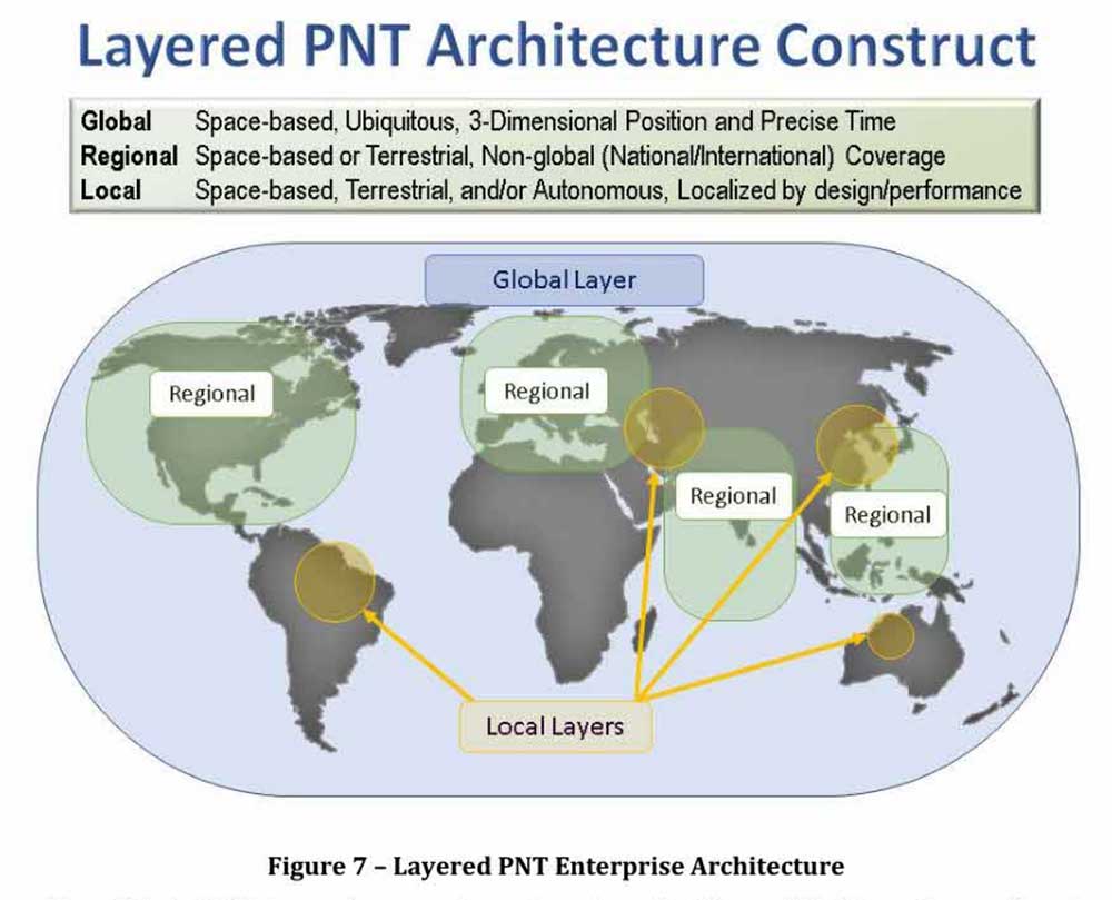
One of the primary ways DoD will deal with is this is to access multiple diverse sources of PNT. These will be in a multi-layered architecture of global, regional and local services.
DOD report figure-architecture

The strategy envisions GPS, paired with military-grade receivers, as the primary global layer source. It recognizes that allied GNSS will be available, but observes that DoD has not done any accuracy and integrity assessments to determine their usefulness. And, since “…all are vulnerable to the same interference and jamming effects” as GPS, “…other sources of PNT information with different characteristics are necessary.”

The regional layer is defined by systems that service large areas such as a few countries or even continents. Recognizing that regional sources can be in space, the strategy discusses two low-frequency ground-based systems with characteristics much different from satellites — enhanced Loran (eLoran) and spatial, temporal and orientation information in contested environments (STOIC).

“Their high power and low frequency enable regional/nationwide coverage, spectrally separate from GPS services, accessible in buildings and under water, and transmitted from dispersed terrestrial locations. Each can be considered as a possible complement to GPS, depending upon operational circumstances and requirements.”

Short-range radio frequency systems, clock, inertial, sensory and hybrid PNT services integrated with wireless networks are all cited as possible contributors to the local layer of DoD’s PNT architecture.

Modular, open-systems approach

Receivers that employ a modular, open-systems approach that can ingest and integrate the various sources of PNT information are needed to take advantage of this multi-source, multi-layer strategy. And integration of the various sources must be seamless and invisible to the user, unless they decide otherwise.

“The employment of multiple PNT sources should not require user awareness or intervention to switch among alternatives during mission execution unless the user elects that option.”

A critical need for implementing this approach, according to the strategy, is the establishment of PNT input/output standards. The document notes that candidate standards have been developed, and it is vital to finalize and approve the standards and bring them into operational service as soon as possible.

Other provisions

The strategy includes a number of other provisions regarding internal DoD processes, the complicated governance process for PNT within the department, and some complex graphics that may be of interest to the larger PNT community.

It also sends several messages about the department’s desires, intent and concerns in the world of PNT that are worth noting.

NAVWAR. The department’s main defensive capability during navigation warfare will be the use of its layered architecture of PNT information and modular, open-systems integration. For offensive operations, it cautions warfighters to not shoot themselves in the foot. PNT is so vital to a wide variety of allied systems, it warns, that denying it to hostiles could do as much damage to friendly forces.

PNT dominience/superiority. At at time when there are more of China’s brand new BeiDou satellites in the skies of many cities, and China is negotiating with Russia for closer BeiDou/GLONASS integration, the strategy calls for the U.S. DoD to achieve PNT dominance. To date, U.S. PNT leadership has been a big contributor to the nation’s political and military leadership in the world. The strategy seeks to continue this.
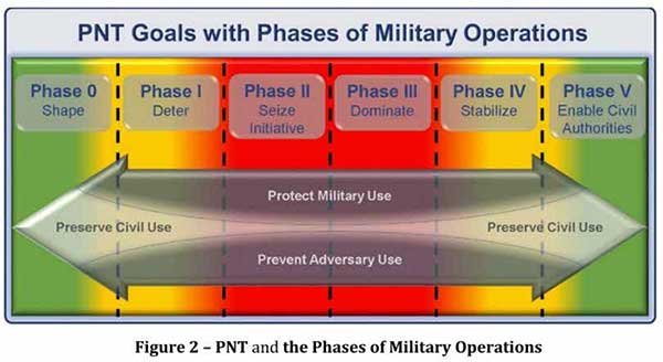
DOD report figureAccelerate M-code receivers. The need to get more M-code GPS receivers into the hands of warfighters is mentioned several times. GPS III satellites have been transmitting M-coded signals that are much more resilient to jamming and spoofing than civil signals since late 2018. These are useless, though, without properly equipped receivers in the field.

Future support to Civil PNT. The strategy also seems to show the department is distancing itself from support of future civil PNT endeavors. While GPS has been an incredible economic engine and boon to civil users, this has not always been in DoD’s best interests.

“It must also be recognized that in this context growing civil dependence on GPS services for critical infrastructure and public use will continue to constrain the ability of the DoD to maintain a military PNT advantage from GPS.”

It goes on to warn that future DoD PNT systems and efforts will not follow the same path to civil-military use as was taken by GPS.

“DOD must take steps to ensure the civil agencies are aware of and are sensitive to the dual-use implications inherent in GPS and other PNT Enterprise applications. From this point forward, many of the specific PNT capabilities and combinations of PNT capabilities employed by the DoD for military purposes will increasingly be classified.”

The way ahead for the 99%

It is clear that the Department of Defense, through the very capable leadership of its CIO, Dana Deasy, has a clear idea of where it is with PNT, its critical challenges, and how to overcome them.

This does not appear to be the case for those in the federal government charged with safeguarding the interests of civil users. With responsibilities fragmented across a host of departments and agencies, efforts on behalf of the public at large are barely visible compared to those the Defense Department is taking to protect itself.

According to officials, this may change. They report that leadership of civil PNT within the executive branch is under review with an eye to making it more efficient and effective.

Perhaps it will result in a PNT strategy for the 99% of GPS users who are not connected with the Defense establishment, making them safer and more secure as well.


“Strategy for the Department of Defense Positioning, Navigation, and Timing (PNT) Enterprise” is available online.

Publicerad den Lämna en kommentar

Tallysman adds 3 more to Helical antenna line

Photo: Tallysman

Photo: Tallysman

Tallysman GNSS has added three new antennas to its Helical antenna line.

Released earlier this year, the helical antenna line provides unprecedented performance in a lightweight, compact form factor.

The line now extends beyond dual-band GNSS and Iridium support to also include single and triple GNSS frequency bands.

Tallysman helical antennas are designed for applications that require high performance and versatility, with an absolute minimum of weight, such as unmanned aerial vehicles (UAVs).

In addition to the HC600, HC871 and HC872, the expanded helical antenna family now includes:

  • the single frequency HC771
  • the dual- frequency (plus L- band corrections) HC882
  • the triple band (plus L- Band corrections) HC975.

The table below lists the complete Tallysman helical Family of antennas.

Chart: Tallysman

Chart: Tallysman

Publicerad den Lämna en kommentar

Stratospheric exploration craft aloft for more than a month

Photo: World View

Photo: World View

World View, the stratospheric exploration company, has reached an important milestone representing a key step toward persistent and navigational stratospheric flight.

After achieving the goal of more than 30 days aloft with full navigational control, the Stratollite completed its 32-day mission over the weekend, showcasing its enhanced long-duration flight capability.

Before this mission, the longest Stratollite flight was 16 days, achieved in June 2019. This mission moves World View closer to scaled commercial operations, making the unique data and information sets it can provide available to commercial and government Earth-observation and remote-sensing customers around the world.

Notable accomplishments from the mission:

  • Executed four continuous days of station-keeping (mission objective) with an average distance of 20 km from the first predetermined target location, followed by an intentional navigation to the second station-keeping target location 1,230 km away.
  • Achieved 2.5 days of continuous station keeping at the second station-keeping target with an average of 40 km from the second target location.
  • Averaged an altitude of 19.5 km during both station-keeping exercises.
  • Traveled more than 11,200 km during the mission, covering Arizona, Utah, Nevada, Colorado, New Mexico, Texas, Oklahoma, Nebraska, Iowa and Kansas.
  • Demonstrated complete navigational control during the mission from World View’s remote Mission Control in Tucson, Arizona.
  • The total mission duration was 32 days, 5 hours and 14 minutes
  • Executed more than 1,000 trajectory-control maneuvers over the entire mission.
Stratollite track: The craft stayed aloft more than 30 days and navigated as planned. (Image: World View)

Stratollite track: The craft stayed aloft more than 30 days and navigated as planned. (Image: World View)

“This is another encouraging milestone for the team and our customers that confirms we are on the right track,” said Ryan Hartman, World View president and CEO. “It sets the stage for a challenging set of missions ahead of us as we continue to push the envelope and demonstrate the ability of the Stratollite to meet customer requirements.”

World View’s flight operations team landed the Stratollite at a predetermined landing zone in Iowa on Saturday, Sept. 28, to conclude the mission. The system landed on command, was recovered, and will be refurbished for reuse on future missions.

World View will continue to increase the cadence of its Stratollite flight operations. The company plans to launch multiple missions focused on demonstrating optical imaging and synthetic aperture radar sensing systems with further enhancement of station-keeping and navigational performance.


About the Stratollite. World View’s Stratollite is a long-endurance stratospheric flight vehicle capable of station-keeping over areas of interest for remote sensing and communications.

The craft can travel 95,000 feet above the Earth. World View is already routinely flying payloads to the edge of space for a wide variety of government, commercial, and education customers.

World View’s proprietary altitude-control technology allows it to harness stratospheric winds to steer the Stratollite to and from desired locations and loiter above them for long durations.

Stratollites can carry a wide variety of commercial payloads (sensors, telescopes, communications arrays, etc.), launch rapidly on demand, and safely return payloads back to Earth after mission completion.

Among its wide variety of uses, the Stratollite will help researchers greatly advance knowledge of planet Earth, improve our ability to identify and track severe weather, and assist first responders during natural disasters.