Stan servicing vehicles at the Lyon Airport. (Photo: Stanley Robotics)
Stan incorporates the Trimble BX992 dual-antenna enclosure for accurate, available and reliable localization
The Stanley Robotics team has called on Trimble to equip Stan, their autonomous parking and valet robot, with accurate localization.
To achieve centimeter-level localization, Stanley Robotics needed to combine perception algorithms and intelligent management software with reliable GNSS technology.
“The robot must move fast to handle high traffic flow and precisely to park cars as densely as possible,” said Anthony Troublé, robot team manager at Stanley Robotics. The team selected the Trimble BX992 dual-antenna enclosure and two Trimble AV59 GNSS antennas.
The BX992 is installed inside the robot and the two antennas are mounted on the robot’s head with maximum separation between them. For the robot to attain centimeter-level localization, a Trimble BX992 base and a Trimble Zephyr antenna are installed at the drop-off cabins where customers leave their cars until robots move them to a more permanent location.
The Trimble BX992 base broadcasts real-time kinematic (RTK) corrections over a Wi-Fi link to the robots.
What Stan Does
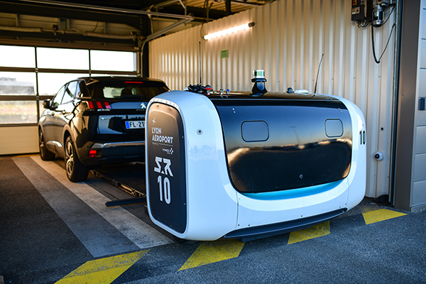
Photo: Stanley Robotics
With the Stan robotic valet, passengers no longer waste time looking for a free space or trying to locate their vehicle, according to Stan’s creators. After booking their parking space in just a few clicks on the Lyon Airport website, passengers drop off their vehicle in dedicated cabins and make their way to the terminals using the shuttle bus located just a few steps away.
The robot takes care of the car, parking it in the secure car park. When they return, passengers pick up their vehicle, which is waiting for them in one of the cabins.
“The service offers security, simplicity and time savings. With this new technology, parking becomes a no-fuss experience that takes only a few minutes of passengers’ time, leaving them free to travel in a relaxed state of mind,” Stanley Robotics said in a press release.
The system also constitutes a new way of arranging vehicles in a car park and makes excellent use of space since cars can be parked in dense blocks.
In addition, the robot uses two lidar scanners and four cameras. Stan relies on lidar-based simultaneous localization and mapping (SLAM) techniques to locate the robot and build a map. The lidar-based SLAM system is always running and is fused with the GNSS localization and odometry.
“The lidar is mostly critical in the cabins where the GNSS availability and reliability is not sufficient,” Troublé said. “The full integration with our localization system, especially the transition from indoor-to-outdoor when the robot enters a cabin was a challenge. We have tuned and improved our localization fusion algorithm to get the best out of each component and deliver a consistent confidence index.”
Stan is equipped with three levels of safety to ensure operational effectiveness.
- First, Stanley Robotics continuously monitors the accuracy, availability and consistency of the RTK GNSS, SLAM and odometry localization signals. “If these signals are too inconsistent or if the overall confidence is too low, the robots are stopped and a site supervisor is alerted,” Troublé said.
- Further, the site is monitored through lidars and cameras on the robot to prevent any collision with obstacles.
- Finally, a trained Stan maintenance worker is assigned to every parking lot. These individuals wear a safety badge. Every robot is equipped with a safe-stop feature that will trigger if the operator gets within a defined proximity to the robot.
The first outdoor car park managed by robots opened to the public in 2018 at Lyon Saint-Exupéry airport. Since testing started in 2017, four Stan robots are now fully operational in the Lyon Saint-Exupéry airport car park, which can accommodate up to 500 vehicles.
Stanley Robotics announced in January 2019 that they will open 2,000 spaces at Lyon in the summer of 2020. The airport is looking to eventually expand this system to up to 6,000 spaces in total.
In 2019, Stanley Robotics signed a contract with Gatwick Airports, the first UK airport to use robots that valet park passengers’ cars. The Stanley Robotics team is gearing up to begin work at another airport to be announced soon.
Gilla detta:
Gilla Laddar in …