Publicerad den Lämna en kommentar

US West Coast now has access to GNSS-powered ShakeAlert app

After 15 years of planning and development, the ShakeAlert earthquake early warning system is now available to more than 50 million people in California, Oregon and Washington, the most earthquake-prone region in the conterminous U.S.

ShakeAlert provides alerts to the general public through public alert systems such as TV, radio and mobile phones. It also slows down trains, opens firehouse doors, closing water and gas valves and

May’s addition of Washington State to the system completes the U.S. Geological Survey and partners’ West Coast rollout of ShakeAlert.

ShakeAlert first launched in California in 2019 and expanded to Oregon in March of this year. People in all three states can now receive alerts from FEMA’s Wireless Emergency Alert system, third-party phone apps, and other technologies.

The ShakeAlert system relies on sensor data from the USGS Advanced National Seismic System. ANSS is a USGS-facilitated collection of regional earthquake monitoring networks operated by partner universities and state geological surveys on the West Coast and throughout the nation.

Part of that data comes from GPS, which the USGS uses to measure crustal deformations over time. The USGS measures the precise position (within 5 mm or less) of GNSS stations near active faults relative to each other.

USGS works closely with ANSS partners and state emergency management agencies on the system’s development as well as public communication, education and outreach.  “USGS science is the backbone of hazard assessment, notification, and response capabilities for communities nationwide so they can plan for, and bounce back from, natural disasters,” said David Applegate, associate director for Natural Hazards Exercising the Delegated Authority of the USGS Director.


See also:

Early earthquake warnings: GNSS could enable 10-second alerts


“Systems powered by ShakeAlert can turn mere seconds into opportunities for people to take life-saving protective actions or for applications to trigger automated actions that protect critical infrastructure,” Applegate said. “An effort like this takes the dedication, ingenuity and hard work of dozens of partners with the same vision, and the USGS is proud to have been part of a collaborative team that made this robust public safety system available for millions of citizens on the West Coast.”

The ShakeAlert earthquake early warning system can save lives and reduce injuries by giving people time to take protective actions like drop, cover and hold on before potentially dangerous earthquake shaking arrives at their location.

In addition to supporting public alerts to mobile phones, ShakeAlert system data has, since late 2018, been used to develop applications that trigger automated actions. Automatic actions can be used to slow down trains to prevent derailments, open firehouse doors so they don’t jam shut and close valves to protect water and gas systems.

The technology will continue to improve over time with the addition of more seismometers to the network, by expanding alert delivery area and by improving messaging speeds.

A GNSS station in the Pacific Northwest geodetic array. (Photo: Central Washington University)

A GNSS station in the Pacific Northwest geodetic array. (Photo: Central Washington University)

Publicerad den Lämna en kommentar

Orolia and Anritsu to launch 5G assisted GPS CAT solutions

Anritsu Corporation and Orolia announce immediate support of assisted GPS (A-GPS) test functionality to meet 5G New Radio (NR) Carrier Acceptance Testing (CAT) requirements for multiple North American operators on the Anritsu ME7834NR 5G mobile device test platform.

As part of the strategic partnership between the two companies, Anritsu leverages Orolia’s GNSS simulation capabilities to deliver A-GPS CAT testing platforms featuring the new Orolia GSG-SKY-ANR solution. The Anritsu MR7834NR supports A-GPS, FR1, FR2, FR1+FR2 NSA and SA US operator signaling requirements on the same platform.

The ME7834NR 5G NR mobile device test platform. (Photo: Anritsu)

The ME7834NR 5G NR mobile device test platform. (Photo: Anritsu)

The A-GPS simulation component of Anritsu’s ME7834NR-based test solution leverages Orolia’s GSG-SKY-ANR simulation platform. The GSG-SKY-ANR is powered by Orolia’s award-winning SKYDEL simulation engine, which delivers flexible, scalable, and efficient GNSS/GPS simulation solutions. The GSG-SKY-ANR GNSS simulator is exclusively available to Anritsu ME7834NR customers.

Anritsu ME7834NR A-GPS-enabled solutions for 5G NR CAT requirements are available immediately. The test solutions support the rollout of nationwide 5G networks by helping to ensure device compliance and optimum operability.

“Anritsu continues to address the needs of our customers globally,” said Shinya Ajiro, general manager of Anritsu Corporation. “By partnering with Orolia, a worldwide leader in GPS simulation technology, we are introducing a reliable, accurate, and cost-effective A-GPS CAT solution that conforms to operator requirements and delivers repeatable results. We remain committed to provide the validation tools necessary for mobile operators, device makers, chipset manufacturers, and test houses to verify designs and ensure product performance. This benefits everyone in the mobile ecosystem.”

“Orolia is proud to support North American operators through our partnership with Anritsu,” said Lisa Perdue, simulation director at Orolia. “Our resilient GPS simulation solutions deliver proven high-end capabilities for critical technology challenges such as the implementation of 5G.”

Publicerad den Lämna en kommentar

Topcon’s MAGNET7 construction and survey software out now

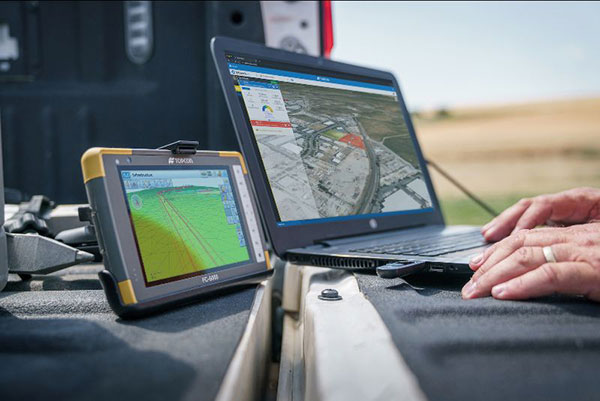
Survey and construction software suite MAGNET 7 is now available from Topcon, using cloud-based connectivity to streamline workflows through GNSS receivers and other equipment.

Photo: Topcon

Photo: Topcon

Survey and construction software suite MAGNET 7 is now available from Topcon Positioning Group.

MAGNET7 uses cloud-based connectivity to streamline workflows through GNSS receivers, total stations and other positioning tools and instruments. It addresses common needs to increase productivity, efficiency and profitability levels across the job site.

The software is also designed to improve accuracy while efficiently managing data and collaboration — in real time — with the project team.

Enhancements in the MAGNET7 field version improve 3D model support, reporting and interactivity in working directly on a visual map. Also improved is data handling for large and complex 3D projects.

Productivity features include an ability to connect to the newest version of the Sitelink3D job-site monitoring and management system. This enables office personnel to send machine models via the web portal directly to machines on site.

The new connection also allows access to the Haul Truck app, which dramatically improves efficiency in the mass-haul environment by sending real-time data — including haul volumes and truck locations — directly to the master schedule.

MAGNET7 provides new capability for calculating the International Roughness Index (IRI), a valuable indicator for resurfacing projects. The IRI data exports directly to ProVAL formats, commonly used in the paving industry, to report and validate road-surface smoothness against government guidelines.

Also provided are enhanced terrain-modeling capabilities for surveyors and an overall increase in file-type capability.

Addressing COVID-19

COVID-19-related demands placed on construction and survey professionals underscore the need for comprehensive, integrated software solutions to meet those challenges head on, according to Alok Srivastava, senior director, product management.

“The push to ramp up production levels and increase efficiency, while operating profitably, has never been greater,” Srivastava said. “Our suite — made up of field software, cloud services, tightly integrated office software and third-party integrations — is a key component of our digital ecosystem, all designed to enhance productivity in the field while helping the office efficiently manage the project dataset. It does so by tapping the power of integrated solutions to provide end-to-end workflows, superior data exchange and a far better level of collaboration.

“We’ve long recognized that many of the basic needs and challenges of today’s survey and construction disciplines are similar. With that in mind, this solution provides compatible, comprehensive, connected answers to many of those shared issues.”

“The need for digital connectivity, both on site and between the office and the job site, has never been greater,” Srivastava said. “With the continued push toward digitization in all facets of their jobs, today’s construction and survey professionals regularly risk loss of efficiency — and the financial costs associated with it — due to issues of incompatibility between equipment and systems. This upgrade of the MAGNET suite of productivity solutions takes connected field and office management to a new level, making the long sought-after ‘end-to-end workflow’ a reality while helping projects stay on schedule and under budget.”

Publicerad den Lämna en kommentar

NSSLGlobal and DDK Positioning offer enhanced GNSS positioning for maritime

DDK Positioning’s precise GNSS positioning solution provides an accuracy of less than 5 cm

NSSLGlobal has entered a strategic alliance with DDK Positioning, to incorporate enhanced GNSS positioning navigation and timing solutions into NSSLGlobal’s maritime portfolio.

NSSLGlobal will now provide, install and service DDK’s GNSS precise point positioning (PPP) solution which enhances the ability of NSSLGlobal’s customers to precisely locate and track their assets.

DDK’s independent GNSS technology is provided exclusively through Iridium’s global satellite constellation, and creates a robust, resilient and completely independent GNSS solution that has an enhanced accuracy of less than 5 cm, compared to the standard GPS accuracy of 10 m.

“This partnership is a fantastic fit for DDK Positioning,” said Kevin Gaffney, DDK Positioning CEO. “We are now in a place to provide our clients with our precise positioning solutions globally and we are delighted to formalize our working relationship with NSSLGlobal with the signing of this new strategic alliance.

“To continue the journey with such a strong and well-respected company such as NSSLGlobal, and with their reach in the market, makes great sense and we are looking forward to the journey that we will have together.”

“DDK Positioning is leading the field in advanced GNSS positioning,” said Paul Rutherford, service director, NSSLGlobal. “We’re pleased to partner with such an innovative company and to be able to add this technology offering on top of the already extensive navigation and communication portfolio we offer our customers. The system will provide greater location accuracy, along with the ability to help detect and mitigate spoofing.”

Once arriving at port, container vessels are offloaded by ship-to-shore (STS) cranes. (Photo: bfk92/E+/Getty Images)

Photo: bfk92/E+/Getty Images

Publicerad den Lämna en kommentar

Trimble GuidEx enables control of machine navigation

The Trimble GuidEx machine guidance system is an advanced navigation solution to guide machines along route corridors or to specific target areas.

Photo: Trimble

Photo: Trimble

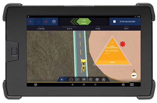
Trimble has introduced the Trimble GuidEx Machine Guidance System, an advanced machine navigation solution intended to quickly and efficiently guide machines along route corridors or to specific target areas, while providing local awareness using customer-provided mapping or engineering data to create exclusion and inclusion zones.

Trimble GuidEx uses an integrated GNSS and inertial navigation system (INS) to compute a virtual reference point and precise heading, pitch and roll.

Users can install the Trimble GuidEx system on anything from utility terrain vehicles (UTVs) to heavy equipment, on- or off-road.

Trimble GuidEx provides streamlined design-stakeout navigation that eliminates the need for advance survey stakeout operations. This enables machine operators to navigate to an exact point without stakes or surveyors, such as for core-sampling operations.

Corridor navigation allows users to efficiently complete a range of tasks including clearing paths for access routes and plowing snow. With comprehensive local machine data-logging, contractors can capture a range of data including position, time and speed.

“Trimble GuidEx was built to meet the needs of natural resource exploration activities, but can be used for many other applications,” said Scott Crozier, vice president of Trimble Civil Construction. “This system improves productivity and awareness with easy, efficient, task-specific navigation.”

To ensure work is done exactly where it should be, proximity and zone breach alarms can be set based on custom exclusion and inclusion zones.

Regardless of the equipment or the application, Trimble GuidEx uses customer-provided data to keep operators aware of prohibited or dangerous areas and decrease time and money wasted on unnecessary work.

Trimble GuidEx provides crossline navigation along predefined routes via an integrated software-based lightbar viewed on the display, including visual and audible alarms when operators breach user-defined distances from a centerline. The system also provides point and pad navigation information with intuitive navigational arrows, supported by a wide variety of data recording settings.

Compatible with virtually any machine type, Trimble GuidEx connects equipment to the office to keep everyone aligned. Operators and supervisors can send mapping data to and from the machine and office to avoid rework.

Reliable guidance data allows contractors to track machines by time or user-defined event triggers for a more accurate representation of the machine utilization cost of a project. Trimble GuidEx can leverage real-time kinematic (RTK) and CenterPoint RTX correction services for enhanced high-accuracy positioning.

Publicerad den Lämna en kommentar

Europes’s GSA becomes EUSPA for stronger space role

EUSPA logoA new space agency launched in Europe today, taking the place of the European GNSS Agency (GSA) and adding responsibilities to encourage Europe’s space enterprises.

The European Union Agency for the Space Program (EUSPA) marks the start of a new era for European Union space, according to an agency statement. EUSPA will build on the legacy of the GSA, which was established to promote use of Galileo and EGNOS, with additional responsibilities to create even more opportunities from space for European Union citizens and its economy.

An April 27 space regulation established EUSPA. Under the new space regulation, EUSPA’s mandate includes promoting Galileo and EGNOS, but with increased responsibilities, including their service provision and operational security. The agency also will coordinate the user-related aspects of government satellite communication in close collaboration with Member States and other entities.

Including Copernicus

Rodrigo da Costa, executive director of the European GNSS Agency. (Photo: GSA)

Rodrigo da Costa, executive director, EUSPA (Photo: EUSPA)

EUSPA is also responsible for the development of downstream markets and fostering of innovation based on Galileo, EGNOS, and now also commercial uses of Copernicus (Europe’s Earth observation satellite program), leveraging funding mechanisms such as Fundamental Elements and Horizon Europe.

EUSPA is also responsible for security accreditation of all the components of the EU Space Program. The European Commission may also decide to entrust the agency with other tasks.

“More and more, our economies, our society and our safety depend on space,” said EUSPA Executive Director Rodrigo da Costa, former director of GSA. “Europe has incredible opportunities ahead that cannot be missed. By creating EUSPA, the European Union will further increase the return on investment made by EU citizens in the EU Space Program by strengthening its contribution to the priorities of the union. We will achieve this primarily by leveraging synergies between the various program components — particularly navigation, Earth observation and secure communications — to drive innovation across a broad range of sectors.”

In particular, bringing management of downstream and combined applications based on Galileo, EGNOS and Copernicus under the umbrella of one agency will make it possible to leverage synergies, according to the agency statement.  “On their own, these technologies can play a key role supporting a digital and green transformation, but leveraging their synergetic and combined use will facilitate the generation of innovative solutions that bring a higher societal impact,” the statement read.

Focus on security

“The teams of committed professionals we have in place at our sites in Europe — from the EGNOS center in Toulouse to the European GNSS Service Centre in Spain and the Galileo Reference Centre in the Netherlands — will continue to ensure the high quality, robustness and reliability of EUSPA’s service provision,” reads the statement. “This will be backed up Galileo security monitoring centers in France and in Spain, and the industrial teams managed by EUSPA in the Galileo control centers in Germany and Italy, along with facilities around the world.”

In addition, the Security Accreditation Board will continue to initiate and monitor implementation of security requirements to ensure a robust and uniform level of security for the entire EU Space Program.

“The new agency has a core role in the security accreditation of all the components of the EU Space Program,” said Bruno Vermeire, chair of EUSPA’s Security Accreditation Board.

Looking to the future

While EUSPA’s mission has expanded, its core aim remains the same – to link EU investment in space to the needs of users in the European Union and around the world.

“The agency remains committed to its traditional users and will continue to deliver the high level of GNSS services that users have come to rely on,” the agency stated. Copernicus and satellite communications will also benefit from the former GSA’s user-oriented focus and “the experience it has gained in developing markets for Galileo and EGNOS.”

Publicerad den Lämna en kommentar

GAO Report: ‘Use resilient tech vs. GPS as DOD primary PNT’

Cover: USGAO Report

Click to open the GAO Report.

A new report by the Government Accountability Office (GAO) questioned the Department of Defense (DOD) strategy of keeping GPS as the central pillar of its positioning, navigation and timing (PNT) capabilities.

It said policymakers “could consider selecting the most resilient technologies as the cornerstone of the PNT suite for military missions, rather than defaulting to GPS.”

The 51-page report takes a comprehensive view of alternative PNT policy and leadership across the department. Its findings are an interesting and informative look at issues and efforts.

Increasing demands

The report comes at a time when U.S. forces have been seeing increasing interference with their own and allied GPS-enabled systems. The Organization for Security and Cooperation in Europe has regularly reported that its surveillance drones in the Ukraine have been jammed. Chinese press recently bragged that jamming caused U.S. Navy ships in the South China Sea to switch from using GPS to the Chinese BeiDou system. Additionally, U.S. military commanders have regularly described the Middle East as the most contested electronic warfare area on the planet, in large part because of regular interference with GPS signals.

The GAO study also comes on the heels of a provision in the National Defense Authorization Act (NDAA) for this year which directs DOD to provide non-GPS PNT to combatant commanders by 2023. The act says this timeline is consistent with responding to Joint Urgent Operational Needs, a formal method for commanders to communicate with department leadership. According to some sources, this suggests that the Pentagon has been receiving such requirements from field commanders, but has not responded to them in what Congress considers a timely manner.

Alternative PNT “not a priority,” resisted

Despite chronic GPS signal interference across the globe, outside experts and officials across the DOD told the GAO study team that developing alternative sources of PNT was not a priority for DOD. One example cited was the lack of a central program office.

One expert said, “PNT — It’s everyone’s need, but nobody’s business.” Another expert said, “Everyone wants to use [PNT], no one wants to pay or care for [PNT].” One DOD official characterized alternative PNT as an afterthought. DOD’s PNT Roadmap states that PNT capabilities, despite being mission critical, are not normally considered a key requirement, but rather may be treated as “a second-tier requirement.”

Worse, the report indicated that some forces within the department resist alternative PNT efforts.
According to one DOD official cited anonymously in the report “bureaucratic and political obstacles [represent] the biggest challenges for alternative PNT” and “anything that threatens GPS, such as alternative PNT technologies, faces pushback.”

The report cited another DOD official as agreeing that “there is an impression that the GPS program has a lot of political clout within DOD, and that those trying to develop alternative PNT technologies may face political challenges.”

Realistic requirements

Many missions do not need the accuracy provided by GPS, according to the report. Nevertheless. DOD programs often default to GPS performance standards when developing requirements. Many alternative technologies, while more resilient, are unable to achieve the same accuracy as GPS and therefore fail to meet the over-stated requirements.

Open architecture

Both DOD and GAO see development of modular open system architecture (MOSA) as key to PNT success in the future. This will allow addition of new PNT sources to a platform without the need for a major retrofit. With MOSA, all that would be needed is a new sensor module for the desired PNT source.

The GAO report endorsed this approach and encouraged DOD to institutionalize it with dedicated funding.

Working with industry

Decades of civil GPS use have benefited DOD in many ways. Broad academic and commercial research has resulted in a host of applications and improvements in the size, weight, and power requirements of equipment, as well as lowered costs. These benefits would almost certainly not have been realized at the current scale if the market for GPS equipment and apps had been restricted to military users.

The 2021 NDAA directs the department to “…enable civilian and commercial adoption…” of the GPS alternative technologies it develops for field commanders. The GAO report suggests DOD also work to leverage industry advances in technologies.

Scope and recommendations

GAO’s tasking for this effort did not include examining efforts to make GPS signals and equipment more resilient to disruption, nor use of non-U.S. satellite navigation systems. Neither were non-defense uses of PNT, nor improvements in such things as tactics, techniques, and procedures considered.

The study focused solely on department efforts to complement GPS services.

Six recommendations for policymakers are included in the report:

  1. Increase Collaboration — Consider mechanisms to coordinate across DOD to clarify responsibilities and authorities in prioritizing the need for alternative PNT technologies.
  2. Focus on Resiliency — Consider selecting the most resilient technologies as the cornerstone of the PNT suite for military missions, rather than defaulting to GPS.
  3. Clarify Requirements — Consider opportunities to clarify what level of PNT performance is actually needed for missions, rather than defaulting to requirements that match GPS performance.
  4. Coordinate with Industry — Consider ensuring that DOD and commercial industry coordinate so that industry is prepared to meet DOD’s needs, and DOD can leverage industry advances.
  5. Institutionalize Open Architecture — Consider making the open architecture initiative more permanent, including providing funding.
  6. Analyze Vulnerabilities — Consider having DOD conduct ongoing analysis of vulnerabilities of different PNT systems.

The May 2021 GAO report “Defense Navigation Capabilities: DOD is Developing Positioning, Navigation, and Timing Technologies to Complement GPS” is available here.


Dana Goward is president of the Resilient Navigation and Timing Foundation.


Feature image: gorodenkoff/iStock/Getty Images Plus/Getty Images

Publicerad den Lämna en kommentar

GPS upgrade: SMC shares constellation modernization plans

By Col. Ryan Colburn
Director, Spectrum Warfare Division and Portfolio Architect,
Space and Missile Systems Center

The United States’ Global Positioning System is used now more than ever before. With an estimated four billion users worldwide, industries of all kinds continue to leverage the precise and consistent data streaming from the GPS satellites. The universal use of GPS signals permeates our lives and creates positive impacts around the globe.

We continue to deliver on our decades-long commitment to provide precise positioning and timing data to the civil, commercial and scientific communities. To support the evolving use of this global utility, the government and industry GPS Enterprise team has embarked on major investments to modernize GPS capabilities for our stakeholders. These efforts are occurring across all of our segments and combine to deliver incremental capabilities and improvements over time.

Colonel Ryan Colburn leads the team dedicated to modernizing the GPS constellation to meet tomorrow’s needs. (Photo: U.S. Space Force)

Colonel Ryan Colburn leads the team dedicated to modernizing the GPS constellation to meet tomorrow’s needs. (Photo: U.S. Space Force)

GPS ENTERPRISE ROADMAP

The GPS Enterprise Roadmap is an overview of the many programs we have in execution or planning stages. These efforts will enable us to deliver new and improved positioning, navigation and timing (PNT) capabilities across all segments. We are upgrading each of the three GPS segments (space, control, and user equipment) to deploy modernized capabilities while continually replenishing the GPS constellation; ensuring we have 24 or more operational satellites available at least 95% of the time.

Additionally, we are always working on what’s next. We are actively researching, prototyping and planning; looking at how we will continue to evolve this architecture into one that is more robust and resilient than it is today. Our team is working to define the next set of capabilities for not only the GPS, as the backbone of our architecture, but also for ways to build off of this system and expand our ability to deliver PNT capabilities in new and useful ways.


“We continue to deliver on our decades-long commitment to provide precise positioning and timing data to the civil, commercial and scientific communities.”


2021 UPCOMING MILESTONES

Space Segment

The GPS III program is off to a great start, further enhancing military readiness and bolstering the activities and assurance of all GPS users. The program continues to push space acquisition boundaries with the first reuse of a Falcon 9 rocket for a National Security Space mission.

Slated for launch in June, SV05 will launch on a flight-proven Falcon 9 booster that was recovered after successfully launching SV04 into orbit.

SV05 will continue the GPS constellation modernization effort and will deliver users a bump in performance and accuracy. The satellite features the interoperable L1C signal, the newest civilian L5 signal and anti-jamming improvements. For the military user, SV05 will become the 24th military-code (M-code) satellite, bringing M-code utility to its Initial Operating Capability.

The GPS III SV03 satellite is encapsulated in its protective launch fairings. (Photo: U.S. Space Force)

The GPS III SV03 satellite is encapsulated in its protective launch fairings. (Photo: U.S. Space Force)

Ground Segment

2021 will be a big year for the Next Generation Operational Control System (OCX). OCX will soon complete the installation of an entirely modernized network of 17 global monitoring stations. These stations allow OCX to monitor the full suite of legacy as well as modernized military and civil navigation signals, including L2C and L5.

In the factory, OCX will continue to use a newly accredited GPS System Simulator (GSYS) in support of mission software testing. In parallel, OCX will continue to replace mission equipment with Hewlett-Packard Enterprise hardware prior to its deployment to operational sites. Once deployed, connections to the GPS command and control antennas will begin, and interconnections to other mission systems will be established.

This includes the GPS Global Information Grid Automated Information System (GGA) subsystem, which will ensure timely dissemination of important navigation data to the public. OCX’s Launch and Checkout System (LCS) will be used to launch and initialize GPS III SV05.

OCX 3F is a modification of the OCX baseline to support GPS IIIF-specific mission requirements. OCX 3F will maintain backward compatibility with the existing systems to support the legacy GPS constellation and will integrate future GPS IIIF capabilities. For example, it will implement command and control of the Regional Military Protection (RMP) and Rapid Warfighter Effects requirements. We are on track for an OCX 3F contract award later this year.
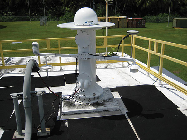
A GPS Antenna is installed at the Diego Garcia Tracking Station, part of the Satellite Control Network operated by the Space Force. (Photo: U.S. Space Force)

A GPS Antenna is installed at the Diego Garcia Tracking Station, part of the Satellite Control Network operated by the Space Force. (Photo: U.S. Space Force)

User Equipment Segment

In 2021, Military GPS User Equipment (MGUE) Increment 1 will culminate its ground user form factor efforts by completing a Field User Evaluation (FUE) of M-Code GPS technology in two service-nominated lead platforms. The Army FUE will be conducted with multiple variants of Stryker vehicles.

Meanwhile, the U.S. Marine Corps will use the Joint Light Tactical Vehicle (JLTV) for their FUE. Both events will assess the performance of the enhanced GPS receivers in operationally relevant environments. Toward the end of 2021, MGUE Increment 1 will deliver the aviation/maritime form factor, which will enable Navy Guided Missile Destroyer (DDG) and USAF B-2 bomber lead platform integration in 2022.

GPS III SV03 is rolled out to the launchpad (above) before its daytime launch on June 30, 2020 (left). The M-code-enabled satellite was joined by SV04 in December. SV05, the 24th M-code-enabled satellite, is expected to launch by July 2021, completing the Initial Operating Capability of M-code. (Photo: U.S. Space Force)

GPS III SV03 is rolled out to the launchpad before its daytime launch on June 30, 2020.

Enterprise Integration

None of these systems are delivered in a vacuum, and we work hard to integrate them all. It is the only way we can continue to deliver on our promises outlined in our published standards. From test campaigns and requirements management, to model-based systems engineering and roadmaps; it takes a united team of government and industry partners to deliver truly integrated capabilities.

We have many exciting milestones this year and we have a world-class government and industry team working tirelessly to ensure continued delivery, maintenance, and operations of GPS Enterprise capabilities. Our motivation is simple — continuing to deliver and evolve the gold standard PNT capabilities we all rely on day in and day out.

The U.S. Space Force’s Space and Missile Systems Center (SMC), located at the Los Angeles Air Force Base in El Segundo, California, is the center of excellence for acquiring and developing military space systems. The SMC’s portfolio includes space launch, global navigation satellite systems, military satellite communications, a meteorological satellite control network, range systems, space-based infrared systems, and space situational awareness capabilities.

The M-code-enabled SV03, shown launching in June 2020, was joined by SV04 in December. SV05, the 24th M-code-enabled satellite, is expected to launch by July 2021, completing the Initial Operating Capability of M-code. (Photo: U.S. Space Force)

The M-code-enabled SV03, shown launching in June 2020, was joined by SV04 in December. SV05, the 24th M-code-enabled satellite, is expected to launch by July 2021, completing the Initial Operating Capability of M-code. (Photo: U.S. Space Force)

Publicerad den Lämna en kommentar

Bad Elf Flex displays power-saving screen

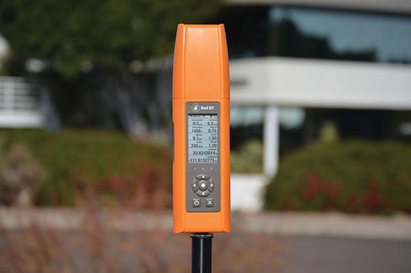
The new display can be easily read in sunlight. (Photo: Bad Elf)

The new display can be easily read in sunlight. (Photo: Bad Elf)

When survey receiver maker Bad Elf set out to make its new Flex device, they knew they had to make the battery last longer. But the device’s screen was eating up power, shortening surveyors’ time in the field.

“As we were building out the idea for Bad Elf Flex, we knew surveyors wanted four things: sunlight readability, a backlight for night visibility, ability to read the screen from a distance of one meter, and a long battery life,” explained Larry Fox, vice president of marketing and business development at Bad Elf. “We found many different display types, but they were all power hungry and not a great fit for surveyors who need to be in the field for a full day.”

After researching options, Bad Elf determined that transflective display technology could offer the power savings and visibility required. The Flex uses Azumo’s reflective LCD technology — a sheet of plastic the width of a human hair. Adhered to the device’s screen stack, it uses a front light instead of a power-hungry back light. The change allows for 90% energy savings.

The new Flex is popular with Bad Elf customers. “They’re getting the kind of quality they want in a high-end receiver, with the affordability they desire. It’s easy to see in the sun, and compatible with a wide variety of apps,” Fox said.

Publicerad den Lämna en kommentar

Taoglas MIMO antennas guide security robots

Enova’s PGuard security robot uses Taoglas antennas. (Photo: Enova Rootics)

Enova’s PGuard security robot uses Taoglas antennas. (Photo: Enova Rootics)

There’s strength in numbers. That’s why antenna systems are increasingly upgrading from single-input/single-output (SISO) architectures to multiple-input/multiple-output (MIMO).

Whether it’s military communications, public safety, smart meters or smartphones, more antenna elements increase channel capacity, reduce transmitting power and increase resistance to multipath fading.

But the smaller the device, the more challenging MIMO becomes from a design perspective, such as providing ample isolation between each antenna element.

Taoglas Pantheon MA750

The Pantheon MA750 antenna. (Photo: Taoglas)

That’s key for ensuring that they don’t interfere with one another, which would reduce channel capacity and system performance. For example, the Taoglas Pantheon MA750 is just 85.7 mm tall, with a 145.6 mm diameter, yet its five antennas have 20 dB+ of isolation.

Three additional key features to look for are high radiation efficiency, low envelope correlation and a built-in ground plane, which provides the flexibility to mount the antenna on metal or plastic without affecting performance.

For applications with long cable runs, such as 10 m, low-loss cables are critical for ensuring that a MIMO antenna can establish and maintain a reliable connection. If the antenna is likely to get wet or struck, it is best to use models with IP67 housings made with ultra-durable materials, such as Wonderloy PC-540 PC/ABS alloy.

Enova Robotics makes security robots. “At Enova Robotics, we know reliability is imperative when you are in the business of security and surveillance. That’s why we chose to work with Taoglas and chose their Pantheon MA750 for our PGuard Robot,” said Ahmed Dimassi, production and supply manager, Enova. “This unique antenna delivers powerful MIMO antenna technology, and we knew we could rely on their team to reduce the risks and time associated with integrating it into our technology.”