Xona has completed environmental testing for its upcoming demo mission, a significant step towards realizing its high-performance commercial navigation system
Xona Space Systems announced that their first in-space demonstrator has been delivered to Spaceflight Inc. for final integration after successfully completing testing and is scheduled for launch on SpaceX’s Transporter 5 in May.
Xona is an aerospace startup developing a precision navigation and timing system in low Earth orbit. It plans to build an independent high-performance satellite navigation and timing system to meet the needs of intelligent systems.
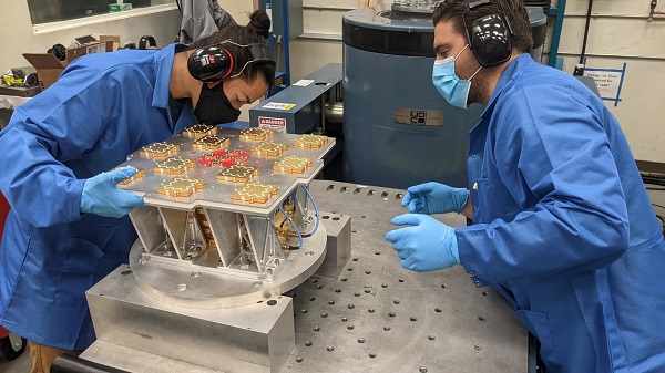
Xona’s first demonstration mission successfully completed testing at Experior Laboratories and prepares for launch on a Falcon 9 in May. (Photo: Xona)
Satellite navigation systems such as GPS and Galileo are in the domain of major governments (and free to users). Xona said it is part of the new commercialized space movement, using it to bring benefits to satellite navigation and timing.
Xona Space is launching Huginn, the first of two missions, demonstrating the capability of its Pulsar constellation. Pulsar’s architecture uses small, powerful satellites in low Earth orbit, more than 20 times closer to Earth than GPS satellites, which are in medium Earth orbit.
Pulsar is planned to deliver high-performance navigation and timing services by combining security and signal designs with Xona’s patent-pending distributed atomic-clock architecture to enable robust precision navigation services from low-cost satellites. Its precision LEO positioning, navigation and timing (PNT) service leverages advances in small satellite technology to provide users with a secure and robust alternative to traditional GNSS.
Xona’s system architecture utilizes the efficiency of small satellites to provide an affordable global system with more than 10 times better accuracy and 100 times better interference mitigation than legacy systems, the company claimed
Huginn will transmit the first precision navigation signals from a LEO spacecraft, designed to test and validate the core software and hardware technology that Xona has developed for Pulsar. The mission will also demonstrate the functionality of end-user equipment on Earth and supporting ground systems.
Huginn is now going through final integration with Spaceflight in preparation for launch on the scheduled Transporter 5 mission in May.
“We’re thrilled that Huginn has successfully completed its very rigorous test campaign in preparation for launch and are incredibly proud of the Xona team for achieving such a critical milestone,” said Brian Manning, CEO of Xona. “Through this process, we learned a massive amount and will be incorporating these lessons into our second demo mission as well as the production satellites.”
Following the Launch of Huginn, the Xona team will shift focus to the second demonstration mission as well as the development of the Block I Pulsar system.
The final Pulsar constellation will consist of several hundred LEO satellites, delivering secure and robust precision PNT services designed to meet the needs of advanced applications such as self-driving cars, precision agriculture and construction, augmented reality, critical infrastructure, and many others.
“It is inspiring to see what this team has been able to achieve going from a blank slate to orbit in less than a year from the time we completed our ground-based prototype testing,” Manning said. “This is a huge step in the development and deployment of our Pulsar constellation, and we’re looking forward to a very exciting year here at Xona.”
Xona is backed by Seraphim Space Investment Trust (LSE:SSIT) and MaC Venture Capital, with participation from Toyota Ventures, Daniel Ammann (co-founder of u-blox), and Ryan Johnson (former CEO of BlackBridge, operator of the Rapideye constellation). Follow-on investors also include 1517 Fund and Stellar Solutions.
Gilla detta:
Gilla Laddar in …