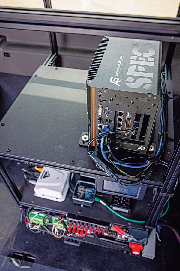
Hexagon | AutonomouStuff’s hardware rack inside the Ford Transit shuttle. (Photo: Hexagon | AutonomouStuff)
When it comes to ground transportation, most of the R&D regarding GNSS is aimed at developing driver-assist systems and, ultimately, driverless cars and trucks. For that purpose, GNSS receivers are integrated with inertial navigation systems, radar, lidar, computer vision and ultrasonics.
Leveraging decades of robotics experience and knowledge of control algorithms, AutonomouStuff, part of Hexagon’s Autonomy & Positioning division, has developed a software stack for autonomous vehicles based on the Apollo open-source software stack.
“Think of this software stack as a brain powering the autonomous platform,” said Kevin Fay, product manager for Hexagon’s platforms and vehicle software business. The software stack can be customized across platforms and to meet equipment needs.
Most recently, in a collaborative project with the National Advanced Driving Simulator at the University of Iowa, AutonomouStuff worked with the Automated Driving Systems for Rural America project to outfit a Ford Transit 350HD shuttle for autonomous operation. First, it created a drive-by-wire system that enabled electronic control of the vehicle, and then it installed positioning, navigation and perception sensors. The result is a platform ready to be autonomous as soon as the software stack is integrated.
Rural roads — which have a wider range of speeds than urban ones — may be encumbered by wildlife or heavy equipment. They also vary in surface from asphalt to gravel, providing a particularly challenging test environment for the autonomy software.
“The Iowa vehicle has done a sizable amount of automated driving on a combination of urban and rural roads, where traditional sensing falls flat,” Fay said. “It has excelled in areas such as gravel roads that have limited or no lane markings, or are narrower than normal. We deployed it earlier this year to do things such as traffic-light detection with the cameras on board, so that it navigates traffic-light intersections appropriately.”
While rural roads are generally free of the GNSS multipath challenges presented by urban canyons, they also provide fewer navigation landmarks. Another challenge is inclement weather. During snowstorms, Fay pointed out, country roads might be unplowed. “If you run on the right lane of the road all the time, you might be out of the ruts that are on the road, and then you’re struggling to get through.” The vehicle must learn to navigate appropriately in those conditions.
The University of Iowa Ford Transit shuttle is a limited deployment, mainly to collect data for research purposes. Meanwhile, it is giving real rides to residents, though with a safety driver. “They’re always attentive, but their hands will be next to the wheel,” Fay said. “There will be times where they may have to take over.”
Other universities and companies are using the platform to further their autonomy programs. Most of them are doing urban driving in complex routes with live traffic, for a total of a dozen vans nationwide.
Hexagon equips the vehicles with a variety of sensors, including a front-mounted adaptive radar, a roof-mounted Velodyne lidar, a roof-mounted NovAtel GNSS receiver and cameras mounted inside the vehicle. “Which ones we provide depends largely on the customer and on which software they’re deploying,” Fay said. “We provide our customers a complete package that can be used with minimal work out of the box. It has the software, the interface to the vehicle, and sensors on it. But we can also provide them with a vehicle that simply has an interface for control, and they add their own computer and software on top of it.”
Hexagon’s first Ford Transit was deployed in 2021. The company released the current version in the spring of 2022, and the Iowa project is slated to run through the middle of 2023. “We’ve not had something running in live traffic before,” Fay said, “so it allows us to continue to grow our skill sets and our overall expertise.”
Gilla detta:
Gilla Laddar in …