Publicerad den Lämna en kommentar

Coronavirus, organ transport top medical drone uses

With Coronavirus all over the news, it’s actually encouraging to hear that China is making high-level efforts to contain the infection: two isolation hospitals built in just one week in Wuhan where the outbreak began, travel restrictions inside China, very few people being allowed to leave the country, enforced mask-wearing, and local communities in neighboring provinces blocking visits by outsiders.

Two drone-related stories caught my attention, both in China and connected to the virus outbreak — one where drones were being used to enforce “wear-a-mask (see video), and another where disinfectant was being dispensed by drones.
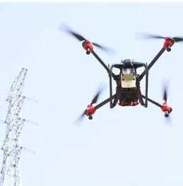
Photo: Xag

Photo: Xag

It’s not exactly clear who was behind recent drone flights that broadcast live warnings to people without protective masks on the streets — some villages in rural China were apparently overflown and people were advised to wear a mask while outdoors.

Around Beijing, similar activities were maybe down to well-intentioned social media people and traffic police.

XAG, which has fielded 42,000 agricultural spraying drones in China, is urging authorities to use its drones for widespread disinfectant spraying, and has set up a significant fund to support these activities. The company claims its drones can disinfect a local community in less than four hours, and may already have done so.

Medical transport drones. Staying with the medical theme, Aquiline Drones (AD) in Cincinnati is a drone company operating under a Federal Aviation Administration (FAA) Part 135 Air Carrier Certificate, and is working on a system to transport human organs for transplants.

VyrtX is an organ transport company in Ohio that has teamed with AD, with the object of creating a highway-in-the-sky across the state to overcome ground delivery delays. Apparently around 25% of precious transplant organs don’t make it in time to be used; they are lost to the patients on lengthy wait lists — and many people are dying as a consequence. There are supposedly enough donors, but organs deteriorate during ground transport and desperate transplant candidates are losing out badly.

So the next step for VyrtX and AD are custom-designed drones for life-saving rapid transport between donor and transplant hospitals. VyrtX is working with the U.S. Air Force Research Laboratory in Dayton, the Ohio UAS Centers and four Ohio organ procurement organizations to develop the air corridor and begin rapid organ transport by drone across the state.

The University of California, San Diego, Health (UC San Diego Health) is joining an increasing number of health organizations in developing a drone system for blood and documentation transport between its facilities. Collaborating with the UPS Flight Forward drone delivery program and with Matternet, medical payloads will travel between Moores Cancer Center and Jacobs Medical Center. The Center for Advanced Laboratory Medicine, about 1.5 miles north, will be added provided initial test flights work out well.

Trained professionals will load and operate the drones, which will follow predetermined, low-risk flight paths and will carry no cameras. (Photo: UC San Diego Health)

Trained professionals will load and operate the drones, which will follow predetermined, low-risk flight paths and will carry no cameras. (Photo: UC San Diego Health)

UPS Flight Forward is another company that was granted (FAA) Part 135 Air Carrier authorization and is already operating a UAS delivery program at WakeMed Hospital in Raleigh, N.C.. UPS Flight Forward is also planning with CVS to deliver prescriptions and other products to CVS pharmacy customers.

Another drone medical supplies delivery system in Tanzania ran an operational trial in the fall of 2018. Wingcopter (a German drone manufacturer), Deutsche Gesellschaft für Internationale Zusammenarbeit (GIZ) GmbH and DHL flew medicines from the mainland to an island. The DHL Parcelcopter completed a 60-km route autonomously in around 40 minutes, for a total of 2,200 km flown during the pilot project.

Building on these earlier trials, Wingcopter is now working with Merck and the Frankfurt University of Applied Science to demonstrate a drone delivery system between two Merck facilities in Germany. The object is to show the benefits of direct drone airborne transport over trucks for moving small packages between a Merck lab in Gernsheim to its headquarters in Darmstadt.

The first flight was recently accomplished over roughly 15.5 miles between the facilities, carrying a sample of pigments.
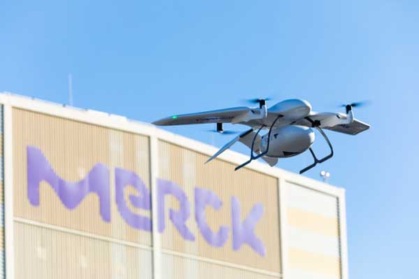
Photo: Wingcopter

Photo: Wingcopter

The BVLOS (beyond visual line of sight) flight passed over a dense metropolitan area, power lines, railways, and roadways. Benefits include time savings of around an hour, provided much greater savings at some times, and avoided significant ground vehicle emissions.

To sum up, drones being used to help combat coronavirus, to reduce time and costs for the transport of medical samples and supplies over medium distances, and there’s a spin-off with potential commercial promise, too. It’s a good month for the drone industry…

Tony Murfin
GNSS Aerospace

Publicerad den Lämna en kommentar

New Leica Nova MS60 enables surveying with one instrument

The new version of all-in-one MultiStation addresses a wide range of needs. (Phoeo: Leica Geosystems)

The new version of all-in-one MultiStation addresses a wide range of needs. (Phoeo: Leica Geosystems)

The new Nova MS60 MultiStation combines upgraded, faster 3D laser-scanning capabilities, GNSS connectivity and digital imaging with a high-end total station. According to Leica Geosystems, part of Hexagon, the multi-station brings sensor fusion to the “next level.”

The MS60 features several laser scanning updates, including an fast scanning speed of up to 30,000 points per second, optimized scan area definitions, adapted scan managements, and an improved scanning path for zenith scans.

It is also equipped with the unique AutoHeight feature, enabling users to save time by automatically measuring the instrument’s height with a simple button press. Measurement professionals can make decisions directly in the field, performing point-cloud analysis such as flatness analysis and as-built checks in the Inspect Surface app of the MS60.

“Scan data combined with traditionally measured points, whether it’s from the total stations or the GPS receivers, is one of those immediate deliverables that help our clients see what we’re doing. With the scan data of the Leica Nova MS60 MultiStation, we can graphically show — the same day it is collecting — the locations in the field to any person,” said Donald Smith, senior land surveyor and principal at BL Companies. “When you deliver on time and provide customers with a deliverable they can see, you’ve just got yourself a recurring client.”

The MS60 speeds up workflows by combining technologies in this all-in-one instrument. The MultiStation  total station offers advanced imaging, scanning capabilities and GNSS connectivity. With Leica Captivate field software, all measurement and scanning data can be visualized in 3D for quality and completeness checks.

MS60 users can seamlessly transfer all data into Leica Infinity software to manage, process, analyze and perform a quality check. The MultiStation helps users deliver projects on time, save money and have high flexibility in the field.

“The MS60 merges data in a multi-level process — total station measurements are complemented by 3D point clouds, which are automatically registered and coloured by the image information. All data perfectly fits within the same coordinate system, globally referenced by GNSS measurements or by measuring known points,” said Falko Henning, senior product manager at Leica Geosystems.

“Unlike other measurement devices, the MS60 offers familiar total station capabilities and scanning functionality to fulfil job requirements on site.” Henning said. “The operator can use the red laser pointer to perform reflectorless measurements for direct remedial work on-site or stakeout points and use the field controller even while a scan is performed.”

Publicerad den Lämna en kommentar

Apple applies for machine learning GNSS device

Logo: Apple

Earlier this month, Apple applied to the Federal Communications Commission for to a license to install GPS testing equipment on its headquarters campus.

This may be related to an application filed by Apple Inc. with the U.S. Patent Office in August 2019, which describes the company’s “Machine Learning Assisted Satellite Based Positioning.”

From the patent application:

MACHINE LEARNING ASSISTED SATELLITE BASED POSITIONING

A device implementing a system for estimating device location includes at least one processor configured to receive an estimated position based on a positioning system comprising a Global Navigation Satellite System (GNSS) satellite, and receive a set of parameters associated with the estimated position.

The processor is further configured to apply the set of parameters and the estimated position to a machine learning model, the machine learning model having been trained based at least on a position of a receiving device relative to the GNSS satellite.

The processor is further configured to provide the estimated position and an output of the machine learning model to a Kalman filter, and provide an estimated device location based on an output of the Kalman filter.

In 2015, Apple acquired the small enhanced-GPS company Coherent to aid the speed and accuracy of its devices’ location services. Presumably, Apple intends to incorporate its machine-learning positioning method into its navigation software.

Publicerad den Lämna en kommentar

FAA, AUVSI to co-host fifth annual FAA UAS Symposium

Logo: FAA UAS SymposiumThe Federal Aviation Administration (FAA) and Association for Unmanned Vehicle Systems International (AUVSI) will co-host the 5th Annual FAA Unmanned Aircraft Systems (UAS) Symposium June 16-18 in Baltimore. The event will take place at the Baltimore Convention Center.

The symposium will bring together representatives from the FAA, other government agencies, the industry and academia. According to the show organizers, the presenters and panelists will discuss the latest information and advancements related to the diverse uses of unmanned aircraft, and how these new entrants are being safely integrated into the National Airspace System.

The show will include four primary educational tracks, including public safety, technology and innovation, international and policy. The public safety track will explore topics such as addressing community concerns, security, and using drones to conduct safer and more effective public safety missions. The technology and innovation track will cover how drones and drone technologies are innovating rapidly and fundamentally changing aviation. The international track will feature discussions on how national and international UAS experts, industry representatives, civil society stakeholders, non-governmental organizations and policy makers are working to integrate and use drones across the globe. Finally, the policy track will allow attendees to hear directly from policy decision makers and get their thoughts on regulatory, operational and technical concerns.

In addition, the FAA will operate as an on-site resource center to answer questions from UAS owners and operators. Subject matter experts will be on hand to answer questions about airspace authorizations, waivers, the Part 107 small UAS rule, changes in hobbyists’ drone operations, the Remote Identification rulemaking, and other policies and regulations, the organizers added.

Publicerad den Lämna en kommentar

EGNOS payload enters service on Eutelsat 5 West B

The EGNOS payload aboard the Eutelsat 5 West B satellite has entered service, according to Eutelsat Communications. The satellite carries a payload for the European GNSS Agency (GSA) called GEO-3. GEO-3 is designed to be aboard a geostationary satellite to augment GNSS signals.

A solar-array problem affected the satellite shortly after its Oct. 9 launch.

Eutelsat 5 West B is hosting the EGNOS payload under a 15-year agreement signed in 2017 with the European GNSS Agency (GSA). The contract also includes technical services and a European ground infrastructure, including two gateways installed at Eutelsat’s Rambouillet and Cagliari teleports.

Image: GSA

Image: GSA

“Eutelsat is proud of the collaboration with its customer GSA, its partners including the European Space Agency, and its suppliers, culminating in the entry into service of this next generation technology of EGNOS on Eutelsat 5 West B,” said Yohann Leroy, Eutelsat’s Deputy CEO and Chief Technical Officer. “We are delighted to host this payload, which will significantly enhance the performance of global navigation satellite systems across Europe, notably Galileo, in the coming years.”

“With this new payload in service, EGNOS is moving towards the transition to its new generation,” said Pascal Claudel, GSA acting executive director and CEO. “This has been done thanks to the constructive collaboration with Eutelsat. Delivery and continuity of satellite services are part of our mission as delegated by the European Commission. It is essential that we, at the GSA, ensure these services to support economic growth and that the European Union’s citizens and companies can benefit from the latest GNSS technology.”

Publicerad den Lämna en kommentar

UAV Navigation compatible with new Trimble UAS1 GNSS receiver

UAV Navigation announced today that its flight control solutions for remotely piloted air systems/unmanned aerial vehicles (RPAS/UAVs) are compatible with the Trimble UAS1, a high-precision GNSS receiver. The core benefits of Trimble’s GNSS solution include centimeter-level precision and easy integration.

Image: UAV Navigation and Trimble

Image: UAV Navigation and Trimble

The light, small Trimble UAS1 receiver is less vulnerable to vibrations or temperature fluctuations, making it suitable for UAVs and RPAS. In addition, the receiver can provide real-time kinematic (RTK) positioning using a base station, enabling users to achieve higher precision for their projects.

Most UAV missions demand precision in its subsystems. The Trimble UAS1 receiver meets these requirements and includes a 336-channel high-precision GNSS engine. It tracks L1/L2 frequencies from the GPS, GLONASS, Galileo and BeiDou constellations.

The Trimble UAS1 supports OmniSTAR and Trimble CenterPoint RTX GNSS corrections, which enable precise and robust positioning without the use of a base station via a subscription service. The receiver also offers an industry-standard camera hot-shoe interface and a wide DC voltage range to work in a broad range of UAVs.

While Trimble is highly specialized in providing advanced GNSS solutions, UAV Navigation’s focus is on innovations in flight control systems. With this combined technology, current UAV/RPAS systems can now operate in more demanding environments and deliver higher precision through better navigation, UAV Navigation stated in a press release.

Publicerad den Lämna en kommentar

Septentrio launches online shop for GNSS receivers

Image: Septentrio

Image: Septentrio

Septentrio’s new web shop offers direct access to mosaic multi-frequency GNSS receiver module. Customers can purchase the mosaic development kit quickly and easily to evaluate this unique module.

Septentrio has opened an online store shop.septentrio.com, selling high-performance GPS/GNSS module receivers. The web shop is accessible via the Septentrio website, offering customers multi-constellation multi-frequency GNSS technology, which provides reliable centimeter level positions suitable for demanding applications.

The first product available for sale online is mosaic, Septentrio’s most compact GNSS receiver module. This light-weight, low-power receiver brings robust high-accuracy positioning to the mass market. With its security-centered anti-jamming and anti-spoofing technology, mosaic provides positioning to numerous demanding applications such as automotive ADAS, logistics automation, and robotics.

“We see a growing demand for reliable high-accuracy positioning across various industries. As GNSS receivers move towards becoming a commodity, we are providing our customers with easier and faster access to GNSS technology,” said Francois Freulon, senior product manager, Septentrio. “We are happy to offer the mosaic development kit as the first product in the shop, which makes it easy for people to purchase and evaluate the mosaic module and discover its capabilities for delivering robust, highly-accurate positions. “

True multi-frequency multi-constellation technology of mosaic ensures access to every possible signal from all available GNSS constellations including the U.S. GPS, European Galileo, Russian GLONASS, Chinese BeiDou and Japanese QZSS satellites. Septentrio’s advanced field-proven algorithms exploit this signal diversity to deliver maximum positioning availability even in the most difficult environments such as under foliage or in urban areas.

GNSS signals can become jammed by nearby electronics or illegal jammers that emit radio signals interfering with GNSS. Mosaic uses jamming-resistant signal processing making it robust against interference. Its design focuses on continuous, reliable high-accuracy positioning making mosaic suitable for demanding applications such as ADAS, UAVs and industrial automation.

Publicerad den Lämna en kommentar

Executive Order requires resilience of critical PNT infrastructure

On Feb. 12, President Donald Trump signed an Executive Order establishing a comprehensive national policy to promote the responsible use of positioning, navigation and timing (PNT) services by the federal government.

The order directs federal agencies to take steps to reduce disruption of critical infrastructure that relies on PNT, including GPS. It also directs critical infrastructure owners and operators to strengthen their systems’ resilience.

Markets affected include including the electrical power grid, communications infrastructure and mobile devices, all modes of transportation, precision agriculture, weather forecasting and emergency response.

The federal government will engage both the public and private sectors to identify and promote responsible use of PNT services, with the goal of ensuring that “critical infrastructure can withstand disruption or manipulation of PNT services.”

“Because of the widespread adoption of PNT services, the disruption or manipulation of these services has the potential to adversely affect the national and economic security of the United States,” the order states. “To strengthen national resilience, the Federal Government must foster the responsible use of PNT services by critical infrastructure owners and operators,” the order reads.

PNT Profiles

The Commerce Department is tasked with developing PNT profiles, due a year from today, for PNT-dependent  systems, networks and assets. The profiles will be developed through consultation with the private sector.

The profiles will also:

  • identify appropriate PNT services;
  • detect the disruption and manipulation of PNT services; and
  • manage the associated risks to the systems, networks and assets dependent on PNT services.

The profiles will be reviewed and updated every two years.

Reaction to the Order

Reacting to the Executive Order on PNT,  J. David Grossman, executive director of the GPS Innovation Alliance (GPSIA), stated:

“The GPS Innovation Alliance (GPSIA) welcomes today’s Executive Order recognizing the critical economic and societal benefits of GPS and other Global Navigation Satellite Systems (GNSS). Resiliency is among the core attributes that have made GPS the gold standard for delivering positioning, navigation, and timing (PNT) functions to our military as well as a wide range of other sectors, including transportation, agriculture, electricity, and finance. Today’s Executive Order represents a crucial next step in ongoing efforts to maintain the security, robustness, and redundancy of PNT capabilities, including GPS, that millions of Americans rely on every day. GPSIA looks forward to working with key government stakeholders to support the implementation of this effort.”

The Department of Transportation stated,

“Our challenge is to enable increased resilience across our transportation systems and ensure the traveling public and freight transporters experience an increased level of safety and efficiency without the possibility of interference caused by loss or manipulation of PNT.

Department of Homeland Security Acting Secretary Chad F. Wolf said,

“From mobile phone applications to automobile navigation, our digital, interconnected society is dependent every day on PNT services.That is why it’s critically important that PNT services remain properly functioning as a major component of the nation’s critical infrastructure. By adopting responsible use of PNT services, the federal government and owners and operators of critical infrastructure can contribute meaningfully to national resilience and ensure the continuous, uninterrupted delivery of services to the nation.”

Photo: adamkaz/E+/Getty Images

Photo: adamkaz/E+/Getty Images

Publicerad den Lämna en kommentar

Orolia’s Sarbe Evo line meets new Cospas-Sarsat requirements

The new line of Sarbe search and rescue beacons. (Photo: Orolia)

The new line of Sarbe search and rescue beacons. (Photo: Orolia)

Orolia is introducing the Sarbe Evo line at the Singapore Air Show, taking place at the Changi Exhibition Centre Feb. 11-16. The line is being exhibited at Orolia’s Booth G10.

The search-and-rescue (SAR) beacon range has been improved to deliver upgraded operational capabilities, to meet the latest Cospas-Sarsat testability and maintenance requirements.

Part of Orolia since 2011, the Sarbe brand is a worldwide market leader for military (tri-forces) Personal Locator Beacons and Emergency Locator Transmitters. Sarbe beacons have been at the forefront of innovation in life saving Locator Beacons and critical communications for over fifty years.

Sarbe equipment is often integrated into air crew clothing such as Air Crew Life Preservers, ejection seats and survival packs, and can be optionally equipped with remote antennas and automatic activation.

The Sarbe Evo line offers new operational improvements in order to meet revised Cospas-Sarsat requirements in operating lifetime, location accuracy, voice signals management, integrated protocols, testability and maintenance.

Orolia’s development of the Sarbe Evo line has focused on the following key elements to improve customer safety:

  • Upgraded battery management with use-monitoring
  • Exceeds Cospas-Sarsat endurance requirements
  • Built-in-test further enhanced
  • More robust and frequent GPS/GNSS position acquisition with GPS, Galileo and GLONASS satellite constellations
  • Audio system improvement for greater clarity under all operating conditions
  • Introduction of the National Location Protocol
  • Rugged and reliability improvement (qualified to MIL-STD-810G standards) to support complex rescue missions in harsh environments

For both commercial and military needs in SAR operations, Orolia’s main goal remains the provision of highly accurate location data, and real-time voice and data communication to SAR operators through robust line of sight transmission.

Publicerad den Lämna en kommentar

L3Harris passes critical design review for digital GPS IIIF payload

L3Harris logoThe design improves capabilities over the 70% digital payload used for GPS III space vehicles 1-10

L3Harris Technologies passed the critical design review (CDR) phase in development of a fully digital navigation payload for the U.S. Air Force’s GPS III Follow-On satellites.

CDR is a major milestone demonstrating the new payload’s design — specifically the fully digital Mission Data Unit (MDU) — is mature enough to proceed to final development, test and delivery.

The new MDU is the heart of the navigation payload and will provide more powerful signals and ensure flawless atomic clock operations. It will also provide improved capabilities over L3Harris’ 70% digital MDU used for GPS III space vehicles 1-10 (GPS III SV 1-10).

“The digital payload is flexible enough to adapt to advances in GPS technology and future warfighter mission needs,” said Ed Zoiss, president, Space and Airborne Systems, L3Harris. “Proceeding to the next stage in the GPS IIIF navigation payload development process moves the program closer to supporting evolving Air Force mission requirements.”

In September 2018, the Air Force selected GPS III prime contractor Lockheed Martin to build up to 22 GPS IIIF satellites, which add even more capabilities and technology to the new GPS III satellites — including the new fully digital navigation payload. GPS IIIF SV11 and 12 are currently under contract.

L3Harris is in a production cadence, having delivered to Lockheed Martin in July the eighth of 10 navigation payloads for the first 10 GPS III satellites.

GPS III SV 01 and 02 launched in December 2018 and August 2019 respectively, and are performing well on orbit. GPS III SV03 is expected to launch in April.

The remaining payloads are in various stages of integration with the satellites in Lockheed’s Colorado facility. L3Harris has provided navigation technology for every U.S. GPS satellite ever launched.