Publicerad den Lämna en kommentar

Skyborg UAV aiming to join frontline US fighter aircraft

It’s only a few weeks into the new year, yet there’s plenty happening in “UAV land” already. I expect another year of innovations, novel developments and groundbreaking firsts in unmanned aircraft.

This month’s question: What’s a Skyborg? The U.S. Air Force (USAF) has awarded contracts to Kratos, Boeing and General Atomics to prove their approaches to the UAV program.

All three have fielded existing, company-developed drones which are intended to fly alongside and be controlled by the latest frontline U.S. fighter aircraft. The idea is to have expendable force-multiplier unmanned aircraft support the capabilities of high tech, hugely expensive aircraft in order to undertake perhaps more risky missions, with the potential improvement acceptable versus unacceptable losses.

Flying alongside frontline fighter aircraft, these jet-powered unmanned aircraft could undertake more risky close support parts of the mission, where loss of the UAV might be more likely, while the manned aircraft remains outside the high-risk envelope. Hence the term attritable is now being applied to these unmanned accompanying vehicles, which are intended to have a reduced cost profile so that loss of the UAV might be more tolerable.

The Air Force Life Cycle Management Center (AFLCMC) has awarded Skyborg Vanguard Program contract amounts to Boeing ($25.7 million), General Atomics ($14.3 million) and Kratos ($37.8 million) for initial prototyping. All appear to have Skyborg prototypes in development.

Kratos has subsequently announced other contract modifications related to the U.S. Air Force Research Laboratory (AFRL) Low Cost Attritable Aircraft Technology (LCAAT) program.

Boeing will offer a variant of the Airpower Teaming System (ATS) drone being developed in Australia for the Australian Air Force. Engine runs and initial taxi tests were recently completed, however the program went into a short hiatus at the end of 2020 because of high COVID-19 infection rates in and around Sydney.

Boeing will offer a variant of the ATS drone being developed for the Australian Air Force. (Photo: Boeing)

Boeing will offer a variant of the ATS drone being developed for the Australian Air Force. (Photo: Boeing)

General Atomics Aeronautical Systems Inc. (GA-ASI) is in the process of modifying two company-owned Avenger UAVs to incorporate upgraded datalinks and the Skyborg System Design Agent (SDA) software. Flight trials will investigate Artificial Intelligence capability for autonomous control of the UAVs while operating alongside manned aircraft – with the object of demonstrating that “a mix of manned and unmanned aircraft can communicate, collaborate, and operate together,” said David R. Alexander, president of GA-ASI.

General Atomics Avenger unmanned aircraft. (Photo: GA-ASI)

General Atomics Avenger unmanned aircraft. (Photo: GA-ASI)

The jet-powered Avenger aircraft has been under development and evaluation for more than 10 years so it is well characterized, and its performance as a UAV is already understood.

The XQ-58A Valkyrie UAV has benefited from earlier generations of Kratos high-speed jet-powered target systems — something none of the other Skyborg competitors have in their bag of tricks. Kratos has been providing high-speed target drones to the military for a number of years, so jet powered drones are something they have been developing and fielding for a long time.

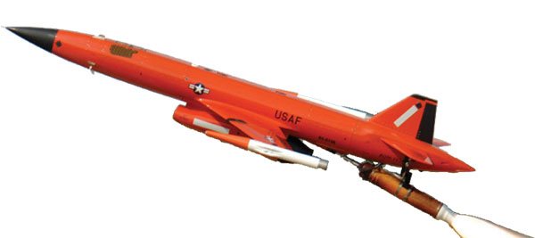
Kratos aerial target drone. (Photo: Kratos)

Kratos aerial target drone. (Photo: Kratos)

XQ-58A Valkyrie UAV. (Photo: Kratos)

XQ-58A Valkyrie UAV. (Photo: Kratos)

The Valkyrie UAV was developed under the USAF Research Laboratory’s Low-Cost Attritable Aircraft Technology (LCAAT) program to demonstrate unmanned low-cost capabilities, and to fly as a stealthy companion to manned aircraft. It is intended to carry internal and wing mounted weapons. The turbine division of Kratos is also investigating lower cost jet engine options for attritable UAVs.

Meanwhile, continuing developments in detect and avoid (DAA) are progressing, moving towards a solution for one of the main problems holding back integration of unmanned aircraft into controlled airspace.

A number of these solutions are based on ADS-B or Automatic Dependent Surveillance Broadcast, whereby the UAV location – usually position provided by onboard GPS — is transmitted at a regular interval by an equipped UAV. So any similarly equipped manned or unmanned aircraft can receive the ADS-B signal, has knowledge of where such flying obstacles might be and is therefore able to avoid a potential collision.

And for pseudo-satellite applications like the Airbus Zephyr which must transition between low-level airspace and the stratosphere, having on-board certified ADS-B is essential so that other aircraft and FAA air-traffic control have full visibility of such a delicate airframe which is lacking great maneuverability during climb-out, on station at altitude and during descent.

Zephyr pseudo-satellite UAV with uAvionix ADS-B transponder and GPS. (Photo: uAvionics)

Zephyr pseudo-satellite UAV with uAvionix ADS-B transponder and GPS. (Photo: uAvionics)

Since Zephyr transitions through Class A airspace, the manufacturer Airbus decided that it should be equipped with an ADS-B transponder and GPS source which had undergone FAA recognized qualification testing and which meets known Technical Standard Order (TSO) requirements.

The equipment also needed to be small and use little power — at 70 grams and using only 2 watts, the uAvionix ping 200X transponder and truFYX GPS provide high power (54 dBm), high integrity transmissions of ADS-B and transponder mode data to Air Traffic Control (ATC) and other suitably equipped aircraft.

Zephyr is an all-electric vehicle, using sunlight to derive power from large photo-voltaic arrays which cover its upper surfaces. Batteries store surplus energy which is not consumed during daylight and provide power in order to maintain aircraft station through the night hours. From a perch at around 70,000ft, Zephyr is apparently focused on Earth-observation capability with payloads envisaged to include Electro Optical, Infrared, Hyper spectral, Passive Radio Frequency (RF) Radar, Synthetic Aperture Radar (SAR), plus Early Warning, Lidar and Automatic Identification System (AIS).

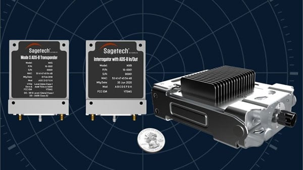
The Hover DAA solution. (Photo: Sagetech)

The Hover DAA solution. (Photo: Sagetech)

“Sagetech is another DAA supplier which is currently working with both fixed and rotary wing UAS customers who are incorporating DAA systems in their design and type certification projects,” said Tom Furey, CEO of Sagetech. “Sagetech is providing regulatory guidance, transponders and interrogators, and system design to ensure these UAV systems in development will satisfy the anticipated certification requirements. Sagetech itself, through technology development and partnerships with companies including Hover Inc., expects to offer a complete DAA prototype system by the end of this year.”

So, lots of progress towards Skyborg drone teaming systems with $78min awards by the Air Force Life Cycle Management Center from an anticipated budget of around $400m, while certified Detect and Avoid solutions help move commercial drones towards potential regular flight in controlled airspace.

Publicerad den Lämna en kommentar

Vodafone tests remote centimeter-level tracking tech

New tech can track vehicles, drones and cargo remotely within centimeters — key to safe adoption of autonomous vehicles, flying objects and machinery

Vodafone logoVodafone has successfully used new precision positioning technology to remotely track a vehicle to within 10 centimeters of its location, an improvement of more than three meters compared to its current system.

Vodafone is working in partnership with Sapcorda, using Vodafone’s global internet of things (IoT) platform, which has  118 million connections worldwide.

Vodafone expects the technology to enable applications that warn autonomous trucks of obstacles, tell first responders the position of critical medical drones, and give operators the precisely location of important cargo.

Pinpoint accuracy is critical to the acceptance and mass adoption of autonomous vehicles on the road and in factories, airports, dockyards and any site where machines are in motion. A matter of centimeters can be crucial to ensuring the safety of passengers on a driverless bus, or knowing the precise location of a medical drone. a

The tracking technology will also allow an autonomous truck to mind other road users, including cyclists, whose e-bikes can automatically transmit their position and intended direction of travel.

“We might not be able to locate a needle in a haystack yet, but we are getting close,” said Vodafone Business Platforms and Solutions Director Justin Shields. “What we can do now is take new digital services like this one, integrate it with our global IoT platform and fast networks, and offer it securely at scale to many millions of customers.

“Our in-building 5G and IoT services already allow manufacturing plants, research laboratories and factories to carry out critical, and often hazardous, precision work with robots. Now we are applying the same levels of accuracy to the outdoor world.”

Vodafone is redefining its network and technology on a Telco as a Service (TaaS) model. It makes key network capabilities available through common APIs in a cloud platform to deliver new software, video and data applications at scale, in addition to gigabit-capable connectivity.

Vodafone said the TaaS model will benefit large enterprises, improving their ability to  locate critical assets, precisely align machines such as driverless trains at platforms, and let farmers, airports, and fleet operators know the exact whereabouts of their autonomous vehicles.

Vodafone IoT-enabled vehicles, machinery and devices — when linked with Sapcorda’s comprehensive network of GNSS receivers and augmentation technology — improves location accuracy by correcting for things like the curvature of the earth, atmospheric delays and clock differences of global positioning satellites. This offers corporations hyper-precise positioning that they can use to ensure a safe environment for their employees, their customers, the public and their machines.

Combined with video and onboard diagnostics, the technology will also allow vehicle operators to carry out accurate location-sensitive remote inspections and even pause machines such as grass cutters on public footpaths when they encounter people.

PPP-RTK method. Vodafone is adopting the precise point positioning – real-time kinematics (PPP-RTK) method with ground-level GNSS stations to achieve the best error correction. GNSS signals are processed and GNSS corrections are sent out to enhance the position accuracy of the vehicles receiving them.

Vodafone is able to equip any number of vehicles with an in-built IoT SIM, and deliver the positioning data at speed using its gigabit-capable networks.

Vodafone recently put this to the test by tracking in real-time the exact lane that vehicles were traveling in during a combined journey of more than 100 kilometers in varying weather conditions.

Sapcorda provided the data feed, which enabled the GNSS signal to be corrected, to deliver the critical-level of positional accuracy. A precise positioning service complements the existing asset tracking and fleet telematics solutions already provided by Vodafone Business for enterprise customers across 54 countries.

Publicerad den Lämna en kommentar

Orolia chosen for GEODE, Galileo PRS project for European defense

Galileo PRS encrypted signal integrated for first time

Orolia, through its France-based entity Orolia Systèmes & Solutions (O2S), has been selected for the GEODE project to develop European standardized and sovereign Galileo PRS positioning, navigation and timing (PNT) receiver capabilities for military applications.

The GEODE (Galileo for EU Defence) program aims at promoting the competitiveness and innovation of the Defense PNT industry in the European Union.

The GEODE consortium will support the prototyping, testing and qualifying of military PNT technologies and resources such as PRS security modules, PRS receivers, GPS/Galileo PRS compatible Controlled Radiation Pattern Antennas (CRPA), and the development of a European PNT test and qualification facility.

As part of this consortium, Orolia brings its proven track record of developing Galileo-based applications and integrating custom signals for commercial and defense critical infrastructure in the GEARS program, and will now focus on the military use of the PRS signal by leading the critical timing and synchronization applications in the GEODE program.

This new PRS support and qualification infrastructure will ensure that the necessary security resources are in place for operational testing, and PNT testing profiles will be defined for naval, land and remotely piloted aircraft platforms.

The applications targeted for these new technologies and capabilities include tactical drones, military satellite and space technologies, unmanned ground vehicles, high precision missile systems, next-gen naval platforms, airborne electronic warfare solutions, resilient networks, cyber situational awareness, and the latest active stealth technologies.

This project will receive about €44M funding from the European Defence Industrial Development Programme (EDIDP) under grant agreement No EDIDP-PNTSCC-2019-039-GEODE.

“We are proud to support the development of future resilient military technologies that will increase safety and security in the European Union,” said Orolia CEO Jean-Yves Courtois. “As the world leader in resilient PNT, Orolia is uniquely positioned to offer the most advanced technologies for timing, synchronization, and GNSS testing and simulation, including encrypted GPS and Galileo signals.”

Orolia Systèmes et Solutions (O2S). In 2019, Orolia launched Orolia Systèmes and Solutions (O2S), a France-based entity dedicated to providing advanced resilient Positioning, Navigation and Timing (PNT) solutions and custom engineering services to French and EU Defense organizations.

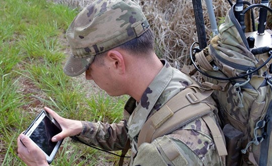
Photo: US Army

Photo: U.S. Army

Publicerad den Lämna en kommentar

GPS coalition asks White House to fix Ligado/5G chaos

GPSIA logoThe GPS Innovation Alliance (GPSIA) sent a letter on Feb. 16 to the White House National Economic Council, asking it “to look at ways to fix the interagency chaos over 5G airwaves that plagued the Trump era,” said J. David Grossman, GPSIA executive director.

“Such fights still haunt the incoming Biden administration and came up repeatedly during the confirmation hearing for Commerce secretary nominee Gina Raimondo,” writes Grossman on behalf of the GPSIA. “Biden’s FCC and executive branch will have to consider whether there are better ways to resolve such turf wars.”

“For example, in the Ligado case, despite the stated objections of 13 federal agencies and departments, the FCC proceeded independently, ignoring expert federal agencies whose missions and responsibilities include management, operation, and reliance upon GPS.”


Panel on risks to sat services

GPSIA’s J. David Grossman will be speaking Feb. 17 at 2 p.m. ET, in a panel discussion entitled “Satellite-Based Services at Risk?” Other speakers include former FCC Commissioner Robert McDowell; Capt. Steve Jangelis, representing the Air Line Pilots Association (ALPA); and Susan Avery, former president of the Woods Hole Oceanographic Institution. Register here.


The coalition, which counts Garmin and John Deere among members, was ensnared in the dispute between Trump executive branch agencies and the FCC over whether the commission’s Ligado approval decision in 2020 would scramble GPS.

In the letter to NEC Director Brian Deese, the group argues that these squabbles “are not unique to GPS” and “reflect a continued pattern by which shared decision-making is replaced by the FCC acting with exclusive authority as the final arbiter.”

GPSIA recommends that the council

  • update a memorandum of understanding between the FCC and Commerce Department to help ease decision-making;
  • install a detailee from federal agencies managing GPS in the FCC’s engineering office; and
  • have each FCC commissioner add a technical adviser to its staff.

The letter concludes, “GPSIA and its members stand ready to be a resource to the NEC and others in the Administration seeking to more efficiently allocate spectrum, while protecting critical incumbent systems and services.”

Publicerad den Lämna en kommentar

France chooses Airbus fixed-wing drone for ships

French ministry for Armed Forces selects Airbus Survey Copter Aliaca fixed-wing drone systems to equip its ships

Airbus Defence and Space mini UAS subsidiary Survey Copter signed a contract with French DGA Armament general directorate to provide the French Navy with 11 systems, (22 aircraft), of the electrically powered fixed-wing Aliaca maritime version UAS (officially called SMDM / “Systèmes de Mini Drones aériens embarqués pour la Marine” by French authorities), including training and integrated logistic support. First deliveries are expected in 2021.

“We are honored to contribute to the missions of the French Navy which we will support with the highest standards of quality and reliability,” said Nicolas Askamp, head of Survey Copter/Airbus Unmanned Aerial Systems. “This new contract strengthens Survey Copter’s position as a global key player for maritime mini UAS.”

The Aliaca maritime UAS is a high-endurance versatile system allowing up to 3 hours missions over a 50 km (27 Nm) range, perfectly adapted to maritime missions with high gyro stabilized EO/IR payload performances and qualified to operate in severe environmental conditions.

The Aliaca SMDM is catapulted from a ship deck. (Photo: Airbus Defence and Space0

The Aliaca SMDM is catapulted from a ship deck. (Photo: Airbus Defence and Space)

Launched by catapult, the Aliaca maritime UAS concludes its flight by landing automatically using a dedicated net landing solution. With a length of 2,2m and a wingspan of 3,6m for a maximum take-off weight of 16 kg., the Aliaca maritime UAS benefits from a powerful yet silent electric motor. The system can be deployed easily and rapidly in less than 15 minutes by 2 operators only.

Similarly, the user-friendly ground control station enables the operator to constantly monitor the automatic flight of the UAS while receiving in real-time day and night images and AIS (Automatic Identification System) data gathered by its on-board sensors.

It is designed to conduct several types of missions around the ships, including increasing the understanding of the tactical situation, control of illegal operations at sea, search-and-rescue, traffic monitoring, pollution detection, tracking of any suspicious behavior in the ship environment and coastal surveillance.

This light on-board aerial solution gives the opportunity to vessels, traditionally not equipped with aerial assets, to enhance their tactical ISR capabilities, support decision making and reactivity in operations.

The Aliaca maritime UAS can easily be integrated on board any ships, with or without helicopter landing-deck, and its small logistic footprint enables operations and storage on board smaller sized ships. Its integration does not require heavy on-board modification nor storage of specific fuel.

The result of 10 years of R&D investments and on-board experimentations, SURVEY Copter’s off-the-shelf Aliaca maritime UAS is a robust and resistant system to the corrosive maritime environment, an adapted solution to the electromagnetic constraints on board, and benefits from an efficient net recovery system, fully automated, meaning that no human action is required during the recovery phase.

Publicerad den Lämna en kommentar

u-blox presents ALEX-R5 miniature cellular module in SiP form factor

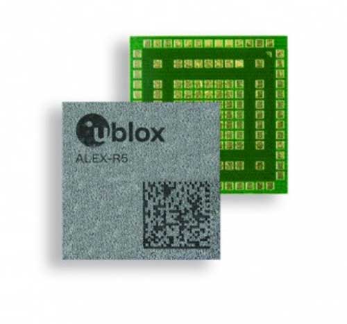
Photo: u-blox

Photo: u-blox

u-blox has debuted the ALEX-R5, a miniature cellular module that integrates low power wide area connectivity and GNSS technology into an ultra-small system-in-package (SiP) form factor.

According to u-blox, ALEX-R5 is based on the secure UBX-R5 LTE-M / NB-IoT chipset platform with out-of-the-box Secure Cloud functionality and the u‑blox M8 GNSS chip for world-class location accuracy.

ALEX-R5 features a 14×14 mm footprint, achieved as a result of its SiP design. It also boasts 23 dBm cellular transmission power that guarantees end devices operate effectively in all signal conditions and a dedicated GNSS antenna interference that enables fully independent, simultaneous operation of the u‑blox M8 GNSS chip.

ALEX-R5 is optimized for power-sensitive and battery-dependent applications, addressing common pain points of size-constrained applications such as wearables and connected medical devices. It achieves this by leveraging the lower power modes of the u‑blox UBX-R5 and UBX-M8 chipsets and giving users options to further balance power consumption and performance using GNSS Super-E mode, u-blox said.

Its rugged SiP construction makes it a perfect fit for harsh environments, where moisture or vibration would be a concern for conventional modules. ALEX-R5 is rated at moisture sensitivity level 3, offering reduced handling and device production complexity, u-blox added.

Finally, ALEX-R5 future-proofs IoT devices and solutions by enabling customers to software upgrade deployed devices for compatibility with 5G networks, u-blox said. This will offer a seamless transition to the next generation of cellular technology as 5G networks are rolled out by mobile operators.

Engineering samples of the ALEX-R5 SiP will be available by the first quarter of 2021.

Publicerad den Lämna en kommentar

Raytheon Intelligence & Space delivers 3,000th GPS receiver

Raytheon Intelligence & Space, a Raytheon Technologies business, delivered its 3,000th MAGR 2000-S24 GPS system to the U.S. Air Force. The MAGR2K is a secure, resilient GPS receiver that allows the warfighter to navigate the battlespace with protection against interference and jamming.

The MAGR2K is an upgrade to the legacy miniaturized airborne GPS receivers and is in service aboard 20 types of fixed-wing and rotary-wing platforms from Department of Defense and Foreign Military Sales customers.

“In the battlespace, disruptions to navigation are not an option,” said Eric Ditmars, vice president of Secure Sensor Solutions at RI&S. “Our MAGR2K GPS receivers enhance GPS acquisition and performance ensuring military forces reliable and assured GPS data they can act on. Delivery of the 3,000th unit is a significant milestone for our team.”

Raytheon Intelligence & Space continues to upgrade the MAGR2K technology to stay current with the evolving battlespace. Development is underway for the MAGR-2K-M, which uses the company’s M-code technology.

The first production readiness units are undergoing platform integration on the U.S. Air Force’s B-2 platform.

B-2 Spirit multi-role bomber capable of delivering both conventional and nuclear munitions. In December 2017, the Air Force completed a series of successful flight tests of M-code GPS using a Raytheon Company receiver on board a B-2 Spirit at Edwards Air Force Base, California. (Photo: U.S. Air Force/Bobby Garcia)

B-2 Spirit multi-role bomber capable of delivering both conventional and nuclear munitions. In December 2017, the Air Force completed a series of successful flight tests of M-code GPS using a Raytheon Company receiver on board a B-2 Spirit at Edwards Air Force Base, California. (Photo: U.S. Air Force/Bobby Garcia)

Publicerad den Lämna en kommentar

ESA: Baltic ferry gathers data for self-aware sailing

News from European Space Agency (ESA)

A day of ferry trips between Finland and Estonia became some of the best documented voyages in maritime history. Cameras, sensors, radio and satellite navigation receivers and even microphones recorded every instant of the crossings over the Baltic, gathering raw data for a new ESA-led project applying artificial intelligence (AI) to the situational awareness of shipping — as an important step to full autonomy.

The Tallink shipping company’s new 212.2 meter-long Megastar passenger and car ferry was fitted with data-gathering devices for its sailings on the busy stretch of sea between Helsinki and Tallinn.

The testing was overseen by a team from the Finnish Geospatial Research Institute (FGI) for an ESA project called Artificial Intelligence/Machine Learning Sensor Fusion for Autonomous Vessel Navigation, or Maritime AI-NAV.

“Our aim is to show how AI can be applied to achieve autonomous situational awareness, so that a ship can reliably sense its own environment,” said FGI’s Sarang Thombre.

Photo: European Space Agency

Photo: European Space Agency

“Such autonomous systems would initially be deployed in support of human crews, for enhanced safety and efficiency – with crewless ships a much longer-term goal.

“The most experienced human ship captains will have the least trust in any single navigational device but will rather continuously cross reference between them. Similarly, our autonomous functionality will not be overly reliant on a single data source but combine and verify data from multiple sensors.

“Having gathered many gigabytes of data during our initial August field campaign, then again in October with more days planned in December, we are applying the results to train and test our data-fusing algorithms. A follow-up seagoing test will then verify their performance in practice.”

The Maritime AI-NAV team plans to employ a variety of sensor types, including satellite navigation receivers – also utilizing of Europe’s Galileo system — monocular and stereo cameras, standard radar, “laser radar” lidar and an array of microphones, along with “Automatic Identification System” radio signals. These AIS signals transmit position, size and routing information of all vessels above a certain class, as well as fixed infrastructure such as oil rigs or wind turbines.

“Satellite navigation lets the ship know where it is in the sea, while the other sensors let it know what is around it, which is essential for identifying and avoiding any obstacles,” Thombre said. “The different data sources operate across a variety of ranges — so radar and AIS provide longer range detection out to the horizon, while cameras and lidars come into their own at shorter distances. Plus we had a trio of microphones aboard the Megastar, determining the angle of arrival of sound from other ships. The challenge now is to fully integrate all these sources using machine learning, to build up a holistic picture.”

Maritime AI-NAV is supported through ESA’s Navigation Innovation and Support Programme, working with European industry and academia to develop innovative navigation technology.

FGI is joined in the Maritime AI-NAV consortium by Aalto University’s Sensor Informatics and Medical Technology group and maritime IT startup Fleetrange.

Publicerad den Lämna en kommentar

New GNSS aboard LEO satellites in development

A new GNSS architecture aboard low-Earth-orbit (LEO) satellites is in development.

The patent-pending system architecture “is combining the efficiency and innovation of the new space era with the world of satellite navigation to help enable modern intelligent systems to operate safely in any conditions, anywhere on the planet,” according to a press release from Xona Space Systems.

Xona, a San Mateo-based startup, announced a service agreement to advance its 2022 Alpha mission. The agreement is with Momentus Inc., a commercial space company offering in-space infrastructure services.

Once complete, Xona’s LEO smallsat constellation will provide a resilient alternative to GNSS with more than 10 times better accuracy, Xona claimed.

“Xona is developing a truly innovative system to enhance the reliability and precision of global PNT and GNSS. As an infrastructure company, Momentus is excited to partner with other like-minded pioneers to help build out the future services needed to enable human presence in space while improving life on earth,” said Dawn Harms, Momentus CEO.

“We have been very impressed with the capabilities and services that Momentus offers with their Vigoride spacecraft,” said Xona CEO Brian Manning. “There is a rapidly growing demand for higher performance navigation and timing services as well as alternatives to GNSS. Forming this partnership with Momentus represents a key milestone in our technology development roadmap as we work towards our on-orbit demonstration and deployment of the full constellation to meet these needs.”

Xona joined the Open PNT Industry Alliance in February.

Publicerad den Lämna en kommentar

DSI to host 2021 Assured PNT Summit in April

Logo: Defense Strategies Institute

The Defense Strategies Institute’s (DSI) Assured Positioning, Navigation & Timing (PNT) Summit will take place April 14-15 at the Mary M. Gates Learning Center in Alexandria, Virginia.

According to DSI, the event will bring together members of the military services, Department of Defense (DoD), federal government, industry and academia in a “town hall” style forum to discuss how important GPS and space-based PNT systems are to the overall resilience of the warfighter, as well as critical infrastructure across the United States and abroad.

The 2021 Assured PNT Summit also will offer senior-level insight into how the U.S. military has been a leader in integrating PNT into its everyday operations and how such capabilities have become vital to the military’s ability to shape the global arena, deter aggression, and fight and win wars.

Confirmed speakers for this year’s event include William Nelson, SES, director, APNT CFT, Army Futures Command; Brig. Gen. Heather L. Pringle, USAF, commander, Air Force Research Laboratory; Anthony C. Smith, SES, director, C3I, DoD CIO; Richard De Fatta, SES, director, U.S. Army Space & Missile Defense Center of Excellence; Cordell “Del” DeLaPena, SES, program executive officer for Space Production Space & Missile Systems Center, USAF; Harold W. Martin III, SES, director, National Coordination Office for Space-Based Positioning, Navigation and Timing; and Col. Jason Joose, USA, chief of staff/APNT signature effort lead, Army Futures Command.

A number of topics will be covered at the 2021 Assured PNT Summit, including:

  • Leading current DoD initiatives toward integrating new PNT capabilities to help the Warfighter remain resilient in a dynamic threat environment;
  • Synchronizing PNT, navigation warfare and space capability development efforts across the Army to help reduce key capability gaps;
  • Delivering resilient, affordable and sustainable space capabilities such as modernized GPS to enhance warfighter superiority;
  • Providing alternate PNT for potential GPS-denied environments;
  • Accelerating the implementation of cutting-edge Air Force research projects such as NTS-3 GPS Satellite to provide the most value to the warfighter;
  • Developing critical PNT-related products to enable a Soldier’s PNT capabilities in all warfighting domains;
  • Overseeing the collection of GPS-related information from multiple federal agencies in an effort to improve and maintain space-based PNT capabilities;
  • Advancing efforts to provide GPS protection for all naval air platforms; and
  • Detailing the Department of Homeland Security plan to test the vulnerabilities of critical infrastructure systems, networks and assets if PNT services were to be disrupted or manipulated.

Register for the event here.