Publicerad den Lämna en kommentar

Surveyors and their global role as humanitarians

Every year, surveying associations worldwide celebrate Global Surveyor’s Day during the third week of March. This year is no different (even during a pandemic) and will be recognized on Tuesday, March 23.

While this past year has been full of challenges, the role of the surveyor on a global scale has continued to grow. As a professional land surveyor in the midwestern portion of the United States, my surveying experiences have been wide-ranging at times.

For those who know of me and/or have followed my writings here in GPS World, you probably understand how my perspective for the surveying profession has come to be. For those who have no clue about my background, let me give you a brief refresher:

  • Second-generation surveyor, born and raised in Central Illinois, United States
  • Surveyed in rural, suburban and urban environments
  • Began writing for GPS World in 2015 to share my surveying perspective

Even though my surveying career has spanned several decades, my experience has been limited to the areas described above. From my early days of spending hours in the county recorder’s office pouring through tract index books, all the way to viewing parcel shapes, scanned documents and high-resolution aerial imagery in today’s world, it seemed at face value that my experience covered most of the duties of the typical land surveyor.

My career has encountered robotic total stations, all iterations of GPS/GNSS data collection, laser scanning, and now UAV data collection. Throw in the development of the personal computer, COGO and CAD software, the Windows operating system, pen plotters, and countless software breakthroughs, and my perspective of the surveying profession had been front row for all the great things we now take for granted.

However, these advancements, in tandem with growing up in middle-class America, did not prepare me for a recent experience with a surveying/geospatial group new to me.

VCSP Wisdom Workshop

VCSP logoA virtual workshop was recently held to discuss the Volunteer Community Surveyor Program (VCSP) instituted in 2017 by the International Federation of Surveyors (FIG) and the FIG Young Surveyors Network (YSN). More than 125 attendees from worldwide locations logged into the sessions to learn about the program and how to become involved.

The program, titled “Sustainable Solutions for Land Based Community Problems: Tools and Modern Approaches,” spanned two days and two four-hour sessions. Before we jump into the specifics of the program, first we will offer another brief refresher on FIG and its YSN.

The Fédération Internationale des Géomètres, now known to English speaking nations as International Federation of Surveyors, was founded in July 1878. It has grown into a worldwide non-governmental organization representing more than 120 countries and their surveying/geomatics professions.

FIG logoThe National Society of Professional Surveyors (NSPS) is a member organization and participates at various levels throughout FIG.

The FIG Young Surveyors Network (FIG YSN) was initially established in 2006 as a working group, and upgraded in 2009 to network status due to its rapid growth. This group of young professionals and practitioners worldwide has worked with groups such as the United Nations, World Bank, National Society of Professional Surveyors (NSPS) and Council of European Geodetic Surveyors (CLGE) to promote the profession, increase opportunities for young professionals, and be an agent for social and climate change.

This YSN workshop set lofty goals, including providing information about the VCSP as well as informing participants of the current means and methods of surveying in underdeveloped countries. For context, here are the program topics covered over the two days:

DAY 1: Community problems, land tenure and tools for land management

  • Experiences and opportunities of humanitarian surveyors (past volunteer community surveys)
  • Land management, community development and open technologies
  • Identifying the relationship between land management and community development
  • The skills of a humanitarian surveyor
  • Introduction to STDM and Cadasta tools
  • An implementation of the STDM and Cadasta tools for land management

DAY 2: Building capacity and implementing modern land-management approaches

  • Leveraging land-management tools for problem solving and decision making
  • Designing country-scale solutions for land rights and tenure security issues
  • Gathering resources for land management projects
  • How much have land rights and tenure insecurity impacted your country?
  • Documenting and publishing experiences
  • What’s next? Parallel sessions by FIG region

Introduction to the humanitarian surveyor

Like most land surveyors in the United States, our role has been well-defined for generations. We establish and/or reestablish parcel boundaries (that is, original or retracement surveys). While our duties have expanded based upon technology, the central responsibility of the surveyor has been established as an expert measurer and provider of boundary information.

In the 200+ years since the westward expansion and formal establishment of most of the United States, the role of the surveyor has evolved into more of a commercial purpose. A surveyor’s principal responsibility is to protect the public, but that meaning has much different connotations in lesser developed countries.
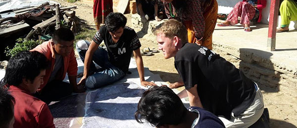
FIG Volunteer Community Surveyor working with locals to discuss parcel possession. (Photo: FIG Young Surveyors)

FIG Volunteer Community Surveyor working with locals to discuss parcel possession. (Photo: FIG Young Surveyors)

In the recent past, surveying efforts in many developing countries have been like the early General Land Office surveyors in the 1800s. A surveyor in these regions is out in front of development of unclaimed lands, observing natural and manmade boundaries to guide the decision-making process in establishing parcel rights. The methods and procedures used to date in many lesser developed countries are much like 19th-century surveying — primitive instruments and crude maps sketch property claims with little to no authority.

Surveying: The Next Generation. Here is where the concept of the community or humanitarian surveyor comes into the picture. A new generation of surveyors is using modern technology not just to map existing boundaries and improvements, but also to collect additional data that will be analyzed to help improve living conditions. With the introduction of GNSS technology, establishment of parcel boundaries now takes an accurate and precise shape in GIS databases created for improving conditions in these areas.

Additional attributes are collected to determine utility needs, communication availability and access to medical care.

The short answer seems to be that, as a larger part of the surveying community, we send teams of surveyors to these countries to locate and establish boundaries as well as perform site studies to determine living conditions and potential improvements. If it were just that easy…

Local government: Friend or foe?

Often, these surveyors are going into regions where the local or national governments do not agree with empowering their citizens with property rights and allowing them access to basic utilities. Part of the humanitarian surveyor’s role is to get to know the “lay of the land” when it comes to local order.

Many remote places are controlled by local gangs, tribes or other factions. These groups forbid the population around them to own their property. Even though it may seem like these physical parcel boundaries exist, most of these people do not have title or land tenure rights. This is partly because of the local control situation, but can also be due to the lack of sophistication within the local or national government.

FIG Volunteer Community Surveyor working with locals to discuss parcel possession. (Photo: FIG Young Surveyors)

FIG Volunteer Community Surveyor working with locals to discuss parcel possession. (Photo: FIG Young Surveyors)

Communication hurdles. Another hurdle for the humanitarian surveyor has nothing to do with their professional capability — it relies solely on appearance, body language and ability to bridge a communication gap. For example, most first-world nations rely strictly on communication skills and the competence to effectively work with other people. We often easily trust those who present evidence of competency with no previous interaction.

In third-world countries, however, locals do not trust outsiders and place competency on those who have built long-term relationships with them. They also rely heavily on body language and facial expressions to convey trust. Local citizens in these areas are less likely to trust visiting older generations who are not able to understand these visual cues.

Combining the factors of trust of the local citizens with the unsteadiness of government and/or lawlessness, the humanitarian surveyor must also be able to determine common property lines, locate lines of occupation, and remain neutral in providing guidance to adjacent neighbors. These conditions often include areas for crops and livestock, as well as places for food growth and development.

With little to no money and lack of commerce available, many of these regions are food poor. Locals are forced to harvest their own food, so having a plot of land to grow these crops is critical.

The surveying procedure for the VCSP. (Image: FIG Young Surveyors)

The surveying procedure for the VCSP. (Image: FIG Young Surveyors)

In more established areas, it can be challenging to determine land tenant rights with many shanties and lean-tos being joined structurally. It is equally difficult to determine if any common utilities exist in these areas, such as stormwater channels to help with rainfall.

Add to these improvement location duties the need for better census data to help with government analyzation of population to apply for aid from other countries.

The good thing is that technology has progressed in creating tools for geographically locating all these entities, including population, with a multitude of attributes to complete proper analyzation. But there is a catch.

Technology challenges worldwide

One of the biggest issue surveyors face when providing services in these areas is the lack of advanced technology and computers. These areas may not have reliable utilities, such as electricity or running water, much less viable internet or Wi-Fi. If computers do exist with local government, they are often years behind in computing power and software. Even operating systems like Windows are a rarity in many of these countries.

Networking accuracy needed. Most humanitarian surveyors will bring their own equipment and computers, so that problem can be averted. But what about geographical locations? Yes, GNSS constellations are available worldwide, but accuracy using just satellite signals is not sufficient for location of parcels and improvements.

To get survey-grade accuracy, the surveyor will typically utilize a correction service or base station on a known value. Most of these corrections are based on Continuously Operating Reference Stations (CORS) or similar established reference stations, so creating a georeferenced datum for the surveyed location takes time and knowledge. Once the network is established, lots of work and oversight is necessary to provide quality control on the data being located.

Tackling parcel management on a global scale. (Image: FIG Young Surveyors)

Tackling parcel management on a global scale. (Image: FIG Young Surveyors)

To add to these issues, most of the staff necessary to complete the surveys must be brought in due to the lack of education at the location. The role of the humanitarian surveyor will also be to teach the craft of surveying to locals, who will continue to expand the area cadaster after the volunteer surveyor has left.

Open-Source Software. However, affording the necessary equipment, computers and software to continue the newly established system is also a hurdle for the community. While the price of computer hardware has greatly reduced over time, the advancement of software and cost of upkeep provides a greater monetary challenge.

Enter open-source software, based upon Linux and other free computer operating systems. This software has been developed with these situations in mind. It allows for customization to each user’s specific need. There are several GIS and data-collection platforms to fit the needs of these budding communities and countries. Open-source and public-domain software allow even the most basic of cadaster needs to be completed efficiently.

Young surveyors network to the rescue

From a technology standpoint, it makes sense that the FIG Young Surveyors Network began this program to help underdeveloped nations begin to create simple cadasters for assessing their property and improvement needs. The younger generation has grown up with technology and can easily teach someone how to embrace it and trust the results.

This younger generation is also the developer of open-source software and tools and sees the value in providing low- to no-cost applications to those who need it most. While the hard part is collecting the data and working with the locals to establish common boundaries, count the population, and determine the utility needs, they take pride in being part of a solution for a segment of the world that may not have any other chance or choice.

Participants in the Volunteer Community Surveyor Program (VCSP). (Photo: FIG Young Surveyors)

Participants in the Volunteer Community Surveyor Program (VCSP). (Photo: FIG Young Surveyors)

One of the interesting portions of the workshop was the breaks between segments. While it was a time to step away from the computer/tablet/phone, the organizers broadcast videos of musical groups from around the world and encouraged the participants to stand up and dance, with their cameras on. While I did not partake in the dancing (it was 4 a.m. at my home), I applaud the Young Surveyors for providing a welcoming atmosphere where each person could be themselves. Several of the participants were in Africa and Asia on cellphones, so creating a workshop environment that worked for all levels of engagement was fascinating.

What I learned

My biggest takeaway was simply learning about the term “humanitarian surveyor.” My earlier reference trying to relate these volunteers to the GLO surveyors, while in the same vein in establishing land boundaries, misses badly in terms of overall contribution to the communities in which the volunteers visit.

The work they perform is truly humanitarian. While I have tried to comprehend the conditions they are facing, I again fall short in fully experiencing what the role has to offer.

One of the testimonials was regarding a group that went to Nepal following the 2015 earthquake to help re-establish towns and parcels. The pictures were stunning, and the memories shared were heartfelt. To be one of these volunteers is truly a humanitarian effort.

Well done, FIG Young Surveyors Network and the Volunteer Community Surveyor Program. I will do my best to not take life here for granted anymore.

Publicerad den Lämna en kommentar

ION hosts webinar on navigation of Mars Perseverance rover

Image: IONThe Institute of Navigation will host the Navigation of the Mars 2020 Perseverance Rover from Earth to Jezero Crater webinar on Tuesday, March 23, at 1:30 p.m. EDT.

The webinar will be presented by Gerhard Kruizinga, navigation engineer, Mars 2020 Navigation Team chief, NASA’s Jet Propulsion Laboratory, and moderated by Frank van Diggelen, ION president.

“We are honored to have the Navigation team chief of this historic mission, Gerhard Kruizinga, present his first-hand account of getting NASA’s Mars 2020 Perseverance Rover from the launch pad to a safe landing on Mars,” van Diggelen said.

The precision landing required very high-precision interplanetary navigation and accommodation of entry guidance target requirements, planetary protection requirements and propellant allocation for trajectory correction maneuvers.

The main navigation objective was to predict the trajectory accuracy at atmospheric entry, such that the entry descent and landing system requirements were satisfied for a safe landing. This presentation discusses the planning to meet all navigation requirements and the actual navigation performance during cruise and landing.

Register here for the webinar.

Publicerad den Lämna en kommentar

Topcon partnership with CyArk bolsters cultural site archiving efforts

Screenshot: CyArk

Screenshot: CyArk

Topcon Positioning Group is partnering with CyArk, a non-profit organization committed to the conservation of cultural heritage sites around the globe.

Using 3D digital documentation technology, CyArk works to ensure that culturally significant sites can be thoroughly and accurately documented for the benefit of current and future generations. Many of the technologies needed for doing so come from the geospatial world, making the Topcon partnership a welcome one, according to John Ristevski, CEO of CyArk.

“We have supported the documentation of over 200 sites around the world from the Mosque City of Bagerhat in Bangladesh to the iconic statues on Easter Island, but the need for high precision documentation continues to grow and there are many exciting projects yet to come,” he said. “High-precision measurement and documentation of these culturally significant sites is critical for decision making, so we are thrilled to be partnering with Topcon, an industry leader in that area and more.”

The commitment from Topcon includes GNSS receivers, robotic total stations, field controllers, MAGNET software and a subscription to Topnet Live, the company’s real-time GNSS reference network. According to Ulrich Hermanski, executive vice president of Geopositioning for Topcon Positioning Group, having worked alongside CyArk in the past, it was a pleasure to continue to support the organization in this way.

”Our relationship with CyArk dates back to 2015 when we helped them digitally document the Sogi Power Plant, one of Japan’s national industrial historic sites,” Hermanski said. “We quickly recognized and admired the crucial role they are playing in ensuring cultural landmarks of all types are preserved in a digital format. Our expertise — providing precision measurement solutions — blends perfectly with their needs, now and as they move forward.

“One of the first projects on which they plan to use the new solutions is mapping the redwood grove in Big Basin Redwood State Park, in California, an area that suffered severe damage in the recent wildfires,” Hermanski said. “We are pleased to help with this important effort.”

CyArk’s mission, to record, archive and share the world’s most significant cultural heritage sites, stems from a desire to not only save these places digitally but provide critical information to aid in the physical conservation and restoration of the sites today.

“In recent years alone, we’ve seen instances in which culturally-invaluable sites were damaged or lost to arson, terrorism or the effects of climate change,” said Ristevski. “To know that the accurate digital documentation efforts can play a role in rebuilding or reconstruction is a humbling opportunity. We are grateful to have Topcon partnering with us in our efforts.”

Publicerad den Lämna en kommentar

PNT Integrity Library published to help protect critical infrastructure

Logo CISAThe U.S. Department of Homeland Security (DHS) Science and Technology Directorate (S&T) has published the Positioning, Navigation, and Timing (PNT) Integrity Library and Epsilon Algorithm Suite to protect against GNSS spoofing, or deceiving a GPS device through false signals. These resources advance the design of PNT systems and increase resilience of critical infrastructure to PNT disruptions, according to the Coast Guard Navigation Center.

PNT services, such as GPS, are a national critical function that enable many applications within the critical infrastructure sectors. However, “The increasing reliance on GPS for military, civil and commercial applications makes the system vulnerable,” according to Space Policy Directive-7 (SPD-7), issued Jan. 15. “GPS users must plan for potential signal loss and take reasonable steps to verify or authenticate the integrity of the received GPS data and ranging signal, especially in applications where even small degradations can result in loss of life.”

The PNT Integrity Library and Epsilon Algorithm Suite address this issue by providing users a method to verify the integrity of the received GPS data. “We are excited to release these resources to the PNT community to improve resiliency against potential GPS signal loss,” said DHS S&T PNT Program Manager Brannan Villee.

“Since GPS signals can be jammed or spoofed, critical infrastructure systems should not be designed with the assumption that GPS data will always be available or will always be accurate,” said Jim Platt, chief of Strategic Defense Initiatives at the Cybersecurity and Information Security Agency (CISA) National Risk Management Center. “Application of these tools will provide increased security against GPS disruptions. However, DHS also recommends a holistic defense strategy that considers the integrity of the PNT data from its reception through its use in the supported system.”

The PNT Integrity Library and Epsilon Algorithm Suite are open source and available free of charge. To view more details, visit the DHS S&T PNT Program.

Publicerad den Lämna en kommentar

Editorial Advisory Board PNT Q&A: GPS in popular culture

What is your pet peeve about how GPS/GNSS is portrayed or discussed in the media and popular culture?

Headshot: Terry Moore

Terry Moore, professor emeritus, University of Nottingham

“What really annoys me is the misinformed assumption that SatNav and GNSS are one and the same. There is now a proliferation of ‘Do Not Follow SatNav’ signs [in the United Kingdom], and so many anecdotal stories about accidents caused by drivers blindly following SatNavs in their vehicles. These are almost always due to the deficiencies of the mapping and the route guidance components of the SatNav systems and not due to any problem with GNSS whatsoever. Nevertheless, it is GNSS that takes the blame.”

Terry Moore
University of Nottingham


Headshot: Julian Thomas

Julian Thomas
Managing Director

“In films, you often see what looks like the tracking of a person inside a building using GPS. Yet, this cannot be done currently with satellites and the kind of technology that can track people or objects indoors is highly specialized and localized to that environment.”

Julian Thomas
Racelogic Ltd.


Headshot: Stuart Riley

Stuart Riley, vice president of GNSS technology, Trimble

“My pet peeve is the oversimplification of consumer navigation issues. I ran a few searches for ‘GPS fails’ and almost immediately saw images of cars in water and stuck in narrow streets. All too often, this is attributed to a GPS issue or failure. From a consumer perspective, the overall system from maps to satellites is considered GPS. The reality is that GPS (the satellites and control segment) is extremely reliable. Historically, satellite issues have been minimal. The most likely navigation errors are routing errors and old or erroneous maps, coupled with users blindly following the directions, and, to a lesser extent, receiver design issues (e.g., lack of ICD compliance) and harsh conditions (deep urban canyons).”

Stuart Riley
Trimble


Mitch Narins

Mitch Narins

“For many, GPS/GNSS remains the miracle cure for all that ails you — for position/surveillance (e.g., ADS-B), for navigation (RNAV and RNP), and for the largest user base, time and frequency. Even while acknowledging the risks, many still treat GPS/GNSS interference as the 500-year flood that will ‘never’ happen in their lifetimes and, if it does, can be excused away as force majeure. It seems that in most of the articles I read it is always a sunny day and GPS/GNSS works perfectly. The need to incorporate resiliency is never emphasized. Nobody would buy a car without a spare tire. Isn’t it time for GPS/GNSS users to recognize the need and insist that an appropriate PNT ‘spare’ be included in the deal?”

Mitch Narins
Consultant


Headshot: F. Michael Swiek

Headshot: F. Michael Swiek

“We can chuckle while watching spies, super sleuths, and adventurers receive GPS positions in incredibly challenged environments — even in caves. My main beef is that nowhere is any mention made of who operates GPS. Instead, GPS is treated as an assumed given, embedded in a smart device, constantly and reliably available on demand anywhere and under all conditions. It is about time recognition and credit is given to those who actually make the miracle of GPS happen.”

Michael Swiek
GPS Alliance

Publicerad den Lämna en kommentar

Research Roundup: Advanced high-precision GNSS

Photo: William Barton/iStock/Getty Images Plus/Getty Images

Photo: William Barton/iStock/Getty Images Plus/Getty Images

Of the hundreds of papers researchers presented at the Institute of Navigation’s annual ION GNSS+ conference, which took place virtually Sept. 21–25, the following five focused on advanced technologies in high-precision GNSS. Papers are available at www.ion.org/publications/browse.cfm.

Railway health with GPS + Galileo

Railway infrastructure and vehicle maintenance expenditures are estimated to cost more than €20 billion per year at the European level. This indicates the demand for developing a low-cost system capable of providing prognostic information about the health status of the railway at the points of the interaction between the vehicle and the infrastructure (wheelset, pantograph, rail and catenary). To achieve these capabilities, SIA (System for vehicle-infrastructure Interaction Assets health status monitoring) is being developed by a consortium from five different European countries. Within the SIA, events are captured by a network of sensors, which are time stamped and then accurately geo-referenced by the positioning sub-system of SIA. The positioning sub-system is based on European GNSS (EGNSS) positioning algorithms tailored for the railway environment and comprises onboard as well as back-office processing.

GNSS-based positioning in the railway environment is very challenging. Hence, Galileo with its advanced signal structure is utilized in SIA (in addition to GPS) to improve availability as well as accuracy.

The onboard positioning algorithm has been developed based on a novel GNSS-inertial measurement unit (IMU) hybridized approach. The new approach can overcome frequent measurement gaps within the GNSS observations and maintain the accuracy level required by the SIA. An overview of the back-office positioning in SIA complements the presentation of the onboard processing.

Citation. Moradi, Ramin, Zheng, Yuheng, Hutchinson, Michael, Roth, Michael, Jahan, Kanwal, Goya, Jon, Alvarado, Unai, “Positioning for Train-infrastructure Asset Health Status Monitoring within the SIA-project,” Proceedings of ION GNSS+ 2020, pp. 2948–2959. https://doi.org/10.33012/2020.17636

Snapshot positioning

Snapshot positioning — from a very brief interval of the received satellite signal — is becoming popular for various applications. This paper studies the feasibility of achieving real-time kinematic (RTK) positioning using snapshot data, a method termed Snapshot RTK (SRTK). A major difference of this positioning method is the generation of code and carrier-phase GNSS observables, a procedure the authors explain. To explore the feasibility of achieving RTK under different scenarios, the rate of integer ambiguity resolution (IAR) is assessed by using snapshot measurements generated with different integration times and signal bandwidths under zero-baseline configuration. Under these assumptions, the key factor that influences the RTK fix rate is the code measurement noise. Double difference code measurement errors are evaluated and plotted with the resulting IAR fix rates to find the relationship between them. The performance of using multi-constellation and multi-frequency signals is tested as well. The fix rate can reach 100% when multiple constellations are used. The achieved positioning accuracy is shown to be less than 5 mm in horizontal domain when IAR is achieved successfully.

Citation. Liu, Xiao, Ribot, Miguel Ángel, Gusi-Amigó, Adrià, Closas, Pau, Garcia, Adrià Rovira, Subirana, Jaume Sanz, “RTK Feasibility Analysis for GNSS Snapshot Positioning,” Proceedings of ION GNSS+ 2020, September 2020, pp. 2911–2921. https://doi.org/10.33012/2020.17768

Cooperative positioning

Advances in low-latency communications networks combined with the paradigm of Intelligent Transportation Systems (ITS) have opened opportunities to develop network-based collaborative positioning and navigation. Recent research has fostered the concept of networked GNSS receivers supporting the sharing of raw measurements with other receivers connected to the network. Such measurements (for instance, pseudorange and Doppler) can be processed through Differential GNSS techniques to retrieve inter-receiver distances that can be integrated to improve positioning performance.

This paper investigates an improved Bayesian estimation for a sensorless, tight integration of Differential GNSS-based collaborative measurements through a modified particle filter. A particle filter natively supports the non-Gaussian noise distribution characterizing GNSS-based inter-receiver distances, so the proposed particle filter was designed, implemented and optimized according to the architecture of a proprietary INS-free GNSS software receiver and tested with realistic RF signals, thus showing remarkable improvement in positioning accuracy.

Citation. Minetto, Alex, Gurrieri, Alessandro, Dovis, Fabio, “DGNSS-based Cooperative Positioning using Statistics-Adaptive Particle Filter,” Proceedings of ION GNSS+ 2020, pp. 2652–2666. https://doi.org/10.33012/2020.17530

Virtual base station

RTK (Real Time Kinematic) is a positioning approach that provides centimeter level accuracy by using a reference station. When the rover and the base station are in proximity (short baseline), all common mode errors are eliminated by the double difference, allowing carrier phase ambiguity resolution. But in medium and long baseline cases, ionospheric and tropospheric delays are not completely eliminated, which affects positioning accuracy. This has limited the application of RTK, especially in certain regions where the closest base station is more than 50 km away.

Algorithms like RTK long baseline and VBS (virtual base station) have emerged as an alternative. The virtual base station (VBS) algorithm processes surrounding bases to generate a virtual one within a short distance of the moving rover. By doing so, atmospheric errors will continue to be eliminated in the double-difference model, and, presumably, RTK processing will be assured all across continents.

In this paper, a performance assessment of the algorithm is conducted under various conditions, including high ionospheric activity, high baseline, harsh multipath environments and, finally, in a long trajectory. The results show that the developed VBS algorithm ensures centimeter-level accuracy even under the harshest conditions.

Citation. Saidani, M., Sarri, P., Guinamard, A., Maya, D. Gallego, “Virtual Base Station Algorithm and Performance Assessment,” Proceedings of ION GNSS+ 2020, pp. 2696–2709. https://doi.org/10.33012/2020.17533

Open-world virtual reality

The Open-World Virtual Reality (OWVR) concept combines precise GNSS positioning and a smartphone-grade inertial sensor to provide globally-referenced centimeter-and-degree accurate tracking of a virtual reality headset. Unlike existing augmented and virtual reality systems, which perform camera-based inside-out headset tracking relative to a local reference frame (for instance, an ad-hoc frame fixed to a living room), OWVR’s globally referenced tracking enables a VR experience in which the user’s outdoor exploration is robust to extremes in lighting conditions and local visual texture. This paper introduces the OWVR concept and presents a prototype system with two candidate sensor-fusion architectures, one loosely and one tightly coupled. Comparative performance is evaluated in terms of tracking accuracy and availability of an integer-aperture-test-validated fixed tracking solution. For scenarios with degraded GNSS availability, which will be typical for outdoor VR, the tightly coupled architecture is shown to offer a critical tracking robustness advantage.

Citation. Humphreys, Todd E., Kor, Ronnie Xian Thong, Iannucci, Peter A., Yoder, James E., “Open-World Virtual Reality Headset Tracking,” Proceedings of ION GNSS+, pp. 2931–2947. https://doi.org/10.33012/2020.17635

Publicerad den Lämna en kommentar

Hexagon partners with Navantia for Spanish Navy combat system

Navantia has selected Luciad — Hexagon’s platform for building advanced location intelligence and real-time situational awareness applications — to equip the combat system of five future F-110 frigates for the Spanish Navy.

The agreement will also cover corresponding tests, validations and simulation environments, according to Hexagon’s Geospatial division.

Navantia and the Spanish Ministry of Defense signed a contract for the construction of the F-110 frigates in April 2019.

Starting in 2016, Hexagon’s Luciad was subjected to the strictest technical benchmarks by Navantia and the Spanish Navy, along with other comparable geospatial technologies on the market. Luciad surpassed the competition to secure the partnership.

Since then, Navantia has developed initial versions of the combat system, which integrates sensors, nautical cartography, AIS tracks and more.

“We are proud to support Navantia and the Spanish Navy,” said Jose Luis Peinado, vice president of Hexagon’s Geospatial division. “This partnership represents another step of our expansion in the defense market and is recognition of Hexagon as a leader in geospatial software for mission-critical environments, where robustness and high performance are key.”

As part of the new partnership, Navantia will join a growing list of systems integrators and defense ministries, including NATO, that have chosen Luciad as the engine for command and control, air defense, border surveillance, combat systems, intelligence and more.

Luciad enables intuitive and interactive map-centric views for aviation, smart cities and defense. It can connect to any database and more than 200 data formats, including real-time data with domain-specific standards. Users can guarantee the highest accuracy, as well as visualize situations in 2D and 3D with rich and flexible styling options.

Publicerad den Lämna en kommentar

Orolia schedules ‘Coffee Talk’ on PNT Executive Order

Orolia logoTo mark the one-year anniversary of the PNT Executive Order, Orolia will host an interactive Coffee Talk webinar on March 24 to explore latest developments in the national initiative to protect U.S. critical infrastructure from GPS/GNSS jamming, spoofing and interference.

Panelists from the U.S. Department of Homeland Security (DHS) and the National Institute of Standards and Technology (NIST), among others, will focus on key actions and priorities for 2021 and beyond, including insights and context on recently published works such as the NIST Foundational PNT Profile issued on Feb. 11, 2021, and the DHS Conformance Framework of Dec. 18, 2020.

Critical infrastructure and PNT industry panelists will also share their perspectives on practical ways to increase resiliency and key factors to consider, in view of the latest Executive Order guidance.

More information about Resilient PNT and GNSS jamming/spoofing is available in Orolia’s online resource center.

Panelists include:

  • Ernest Wong, Technical Manager, Science and Technology Directorate, DHS
  • Jim McCarthy, Senior Security Engineer, National CyberSecurity Center of Excellence,  NIST
  • Ya-Shian Li-Baboud, Computer Scientist, Cyber Infrastructure Group, NIST

Register here for the Coffee Talk “PNT Executive Order Update: 2021 Actions and Priorities,” 11 a.m. EDT, March 24. Use the registration form to share questions or comments on what to discuss.

Publicerad den Lämna en kommentar

SPH Engineering’s UgCS software now supports Velos UAV copter

The Velos UAV helicopter has passed field tests to become the first single-rotor helicopter supported by UgCS software, according to UgCS maker SPH Engineering. UgCS now enables Velos helicopter professionals to use Velos for photogrammetry and lidar drone surveying missions.

UgCS is now able to support the twin-engine telemetry providing input for a UAV. Its newly created Telemetry Viewer can handle extensive telemetry from such complex drones. This allows for optimal flying of the Velos helicopter with a fully redundant twin-motor design and double key components.

UgCS allows for the control and monitoring of one or multiple Velos helicopters on a single mission in both single and multi-operator modes.

Photo: Velos UAV

Photo: Velos UAV

The field tests were initiated and conducted by GeoInspect, the first company to use c with its Velos helicopter. The new solution allows professionals to fine-tune projects, resulting in maximum performance and very high usability. One of the projects was a fully autonomous test flight with UgCS.

“GeoInspect has been performing lidar surveys successfully with UgCS for many years,” explained Bart Zondag, GeoInspect founder. “Having started with the M600 model, UgCS is now used to support single-rotor UAVs. We have already delivered a Velos V2 with UgCS to one of our customers to the EU Nordics to perform lidar forestry surveys.”

Learn more about the solution by joining a free Zoom webinar on March 4, 2021.

Publicerad den Lämna en kommentar

Verizon to acquire autonomous navigation company incubed IT

​The acquisition will expand Verizon’s robotic capabilities to power the future of robotic automation for enterprise customers

incubed IT logoVerizon has entered into a definitive agreement to acquire ​incubed IT​, the creator of a software platform providing autonomous navigation tools to administer, manage and optimize mixed fleets of robots in industrial settings.

“This acquisition further demonstrates Verizon’s commitment to developing new and innovative businesses and use cases leveraging the power of 5G,” said Rima Qureshi, chief strategy officer at Verizon. “Mobile robot orchestration is a real and emerging challenge faced by enterprises today. By integrating incubed IT’s autonomous software with Verizon’s 5G platform, we will have the ability to power robotic automation at scale. This will create new opportunities for enterprise customers to better and more effectively monitor and optimize their business processes.”

Upon closing and as Verizon continues to expand its 5G coverage, capacity and mobile-edge compute capabilities, incubed IT’s autonomous software will enable enterprise customers to gain new efficiencies as they scale their autonomous mobile robot fleets.

Incubed IT’s award-winning software enables robots to localize and navigate autonomously and can be easily integrated into nearly any mobile robot.​ ​Their products include:

  • Smart Shuttle Navigation Toolkit:​ Transmits near real-time data to navigate autonomous mobile robots (AMRs)
  • Fleet Management Server: ​Manages AMR Fleet & Routing Operations
  • Data Monitoring and Analytics: ​Near real-time monitoring and advanced
    reporting

“Incubed IT’s next-generation software and autonomous fleet management server are foundational components for the future of terrestrial robotics,” said Elise Neel, vice president of Verizon New Business Incubation. “When we combine incubed IT’s capabilities with the reliability, responsiveness and vast capabilities of Verizon’s 5G platform, we will enable faster, less expensive and more effective adoption of robotic automation for enterprises everywhere.”

Incubed IT’s autonomous navigation software features include:

  • No need to specify transport paths up front
  • No predefined paths
  • Instant rerouting
  • Obstacle avoidance
  • Safe operation in areas with other vehicles and humans

Incubed IT’s employees will join the ​Verizon New Business Incubation​ team, whose mission is to scale new automation businesses, fueled by the inherent orchestration power of 5G. The incubed IT team will continue to drive development, sales and support for its customers and suite of products across a fleet of diversified robotic partners.

“We are proud of all the incubed IT team has accomplished to get us to this point, and we look forward to expanding on our successes and capabilities,” said Stephan Gspandl, incubed IT CEO. “By joining the Verizon team, we have the opportunity to bring our software to broader audiences and to help create the future of robotic automation.”

The transaction is subject to customary closing conditions and is expected to close in the first half of 2021.