Developments in the unmanned space this month include an unmanned cargo aircraft with unmanned passengers, another way drones can deliver really heavy cargo, and a fanciful recreation of a beloved vintage car.
How do you catch a gremlin? Wait, what’s a gremlin?
Gremlins are supposed to be unmanned aircraft which are launched and recovered in flight from a cargo or bomb-carrying aircraft. Flying in small collaborating swarms, gremlins are equipped with sensors for communications, jamming, reconnaissance or other needs.
As envisioned by the U.S. Army’s Defense Advanced Research Projects Agency (DARPA), gremlins are reusable, may be autonomous, can operate in GNSS-denied environments, and can be flown on high-risk missions into high-risk areas — places that high-value manned aircraft would avoid.
DARPA has contracted Dynetics to come up with a system that meets those criteria — a pretty demanding list of capabilities. So far, prototype X-61A UAVs have been built and flown through four flight test campaigns.
Many military technologists have dreamed of unmanned flying aircraft carriers, which could be put to a variety of uses. If the gremlin system works, the commercial world might well find its own applications.
Carried under the wings of a C-130A cargo transport, gremlins have been launched and flown through three flight tests. Capture and recovery has been attempted but was unsuccessful because of unanticipated turbulence. One test vehicle was lost when its parachute recovery system failed — altogether, three vehicles have been lost.
Finally, on Oct. 25 over the Dugway Proving Ground in Utah, one Gremlin X-61A was flown onto the C-130A capture system and successfully recovered.
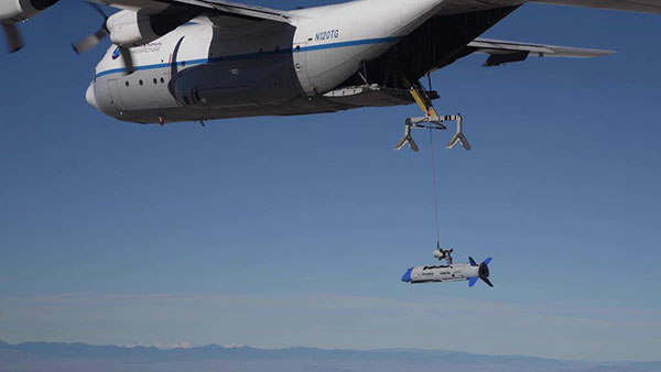
The gremlin X-61A test vehicle is recovered into C-130 transport on its fourth test flight. (Photo: DARPA)
The DARPA program requires a number of Gremlin UAVs to be captured, recovered and stowed in the mother aircraft within 30 minutes. The current recovery system is somewhat complex, so it remains to be seen if subsequent tests can achieve this substantial goal. Recovery might become easier and more reliable with an increase in the degree of autonomous operation for both the UAV and the recovery system.
A Guided Box for Disaster Relief
We turn now from a complex system to a direct and simple one that fulfills a key logistical requirement for disaster relief. It’s a fully autonomous UAV that lacks any integrated power source. Essentially, it’s a guided box.
The AVIUS Air Delivery Mercy-2000 by Yates Electrospace Corp. is basically an air-dropped cargo container that can glide from an altitude of 25,000 feet to a fixed location. From up to 35 miles away, this precision-guided drone can land safely within 110 yards of the desired site and deliver more than 1,600 pounds of material for critical medical and humanitarian needs.
Initially developed for military air-drop purposes (the U.S. Air Force just ordered 15), the cargo container is an 8-foot-long box with two sets of folded wings, fitted with a small nose-cone and a larger tail-cone before launch that help stabilize flight. The wings are carried inside the box and are installed by simply turning over the top cover.
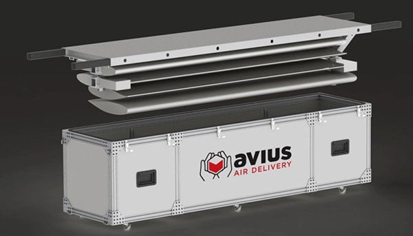
Photo: Yates Electrospace Corp.
The assembly includes the essential guidance system. A COTS (commercial-off-the shelf) GPS receiver, lidar, magnetic heading sensor, barometric altimeter, inertial measurement unit and pitot speed sensor are integrated into proprietary software running on a COTS computer.
Anyone who has ever tried to land a glider from 25,000 feet knows that actually landing safely in the right place is tough to do. It’s quite an achievement to create a reliable, precision, autonomous solution that works when pushed out the back of an aircraft.
New Model of Old Renault Takes Flight
Now to a more fanciful story about an old friend – the Renault 4L. Many of us remember driving or riding in one, with its gear-change on the dash, uncomfortable seats, suspension and “sewing machine” engine.

The Renault 4L was manufactured from 1974 to 1978. (Photo: ribeiroantonio/iStock Editorial/Getty Images Plus/Getty Images)
In celebration of its 60th anniversary, Renault (now part of the Renault–Nissan–Mitsubishi Alliance) and TheArsenale have teamed up in France to make a flying 4L known as the AIR4.
The body shell has been re-engineered in carbon fiber with the same shape of the original 4L. The frame has been built for vertical and horizontal flight, with propellers at each corner of the vehicle. The body shell lifts at the front for pilot access. The Air4 carries lithium polymer batteries, providing up to 90,000 mAh. It can achieve 58 mph when tilted forward at 45°.
The Air4 will go on public display until the end of the year in the center of Paris at the Renault Center on the Champs Elysées, along with other antique models of the Renault 4. Miami will be the next stop for the AIR4, followed by New York and then Macau, China.
To sum up, we have gremlins making progress and being recaptured, a 1-ton flying box for important deliveries, and a celebration of 60 years of the Renault 4L — quite a wide range of ingenious unmanned vehicle applications.
Tony Murfin
GNSS Aerospace